A Barstow Narrative

Barstow, California, from the 1870s through the present, with all key details preserved and arranged chronologically:
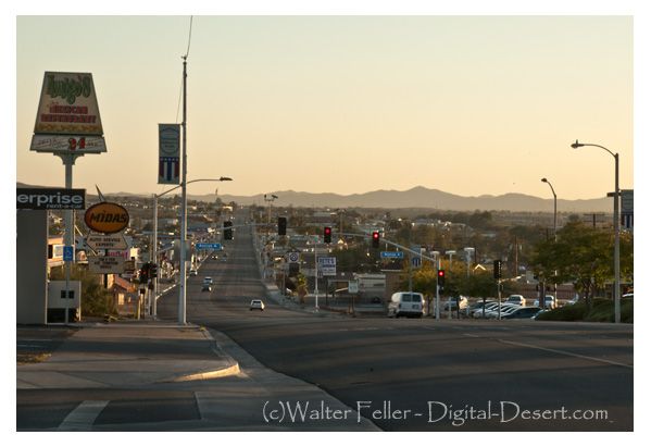

Barstow stands today at the center of the Mojave Desert’s long story of ranching, mining, railroads, and highways. Its history reflects the layered development of the Mojave River corridor, where water, transportation, and enterprise have drawn people across the desert for more than a century and a half.

Mojave River

In the years following the Civil War, the upper Mojave River region supported a few scattered cattle ranches and wagon stations. Before Barstow existed, the country between Oro Grande and Daggett was known for its open range and desert pastures. Herds were grazed along the Mojave River, using its shallow pools, seeps, and hand-dug wells. During the 1870s and 1880s, ranchers moved stock between the high country of the San Bernardino Mountains and the desert valleys, following trails that paralleled the river. Stations at places such as Lane’s Crossing and Fish Ponds served as watering points for stock and travelers. As the Santa Fe Railroad advanced across the desert, freight access to distant markets encouraged limited agriculture along the riverbanks. By the early 1900s, alfalfa, grain, and small orchards appeared in Victor Valley, and a few experimental plots extended downstream toward Barstow. The Arrowhead Reservoir and Power Company began purchasing riparian tracts between Victorville and Barstow to secure water rights, recognizing that the Mojave River would control the future of settlement. Though the arid climate limited cultivation, these early ranches and farms laid the foundation for the region’s first lasting economy before industry and highway travel arrived.

Fish Ponds

Barstow’s founding dates to the early 1880s, when the Atlantic & Pacific Railroad, later part of the Atchison, Topeka & Santa Fe system, pushed its line westward from Needles toward Mojave. In 1883, the mainline was completed across the desert, and a division point was established to centralize maintenance, crew changes, and fueling. This camp, called initially Waterman Junction, became the nucleus of Barstow. The town was renamed in 1884 for William Barstow Strong, president of the Santa Fe, and quickly became the railroad’s desert headquarters. Roundhouses, repair shops, and supply depots were built to serve the trains moving freight and passengers across the Mojave.

Santa Fe

While Barstow developed as a railroad town, the nearby community of Daggett became the milling and shipping center for the Calico silver mines. The Calico district boomed in the early 1880s, with more than a hundred mines producing ore that was hauled to Daggett for reduction and shipment east. In 1898, a short branch line was built from Daggett to Calico to carry ore directly to the Santa Fe main line. This small spur improved mining transport but did not found Barstow; the town was already well established as a division headquarters long before. Barstow’s location on the main transcontinental line—roughly midway between San Bernardino and Needles—gave it strategic importance that would outlast the mining booms around it.

Daggett, CA

As the 1890s ended and silver prices dropped, mining declined, but the railroad presence ensured Barstow’s survival. The town expanded with railroad housing, stores, and services for workers and travelers. The Mojave River valley became a modest agricultural district, producing hay, fruit, and dairy products for local use. By 1910, Barstow had schools, churches, and small businesses serving both rail employees and the surrounding ranch country.

Casa del Desierto, Harvey House

In 1911, the Fred Harvey Company constructed the Casa del Desierto, a grand Mission Revival depot and Harvey House that brought elegance and permanence to the desert town. The building served as a hotel, restaurant, and railroad office, offering travelers comfort along the route between Los Angeles and the Colorado River. It quickly became Barstow’s social center and symbol of progress. The Santa Fe expanded its shops, roundhouse, and yards, reinforcing the town’s position as a key maintenance and operating base.

El Garces, Harvey House

At the same time, the automobile age arrived. The National Old Trails Highway followed the corridor of the railroad, and by the 1920s, U.S. Route 66 brought a steady stream of motorists through town. Gas stations, garages, and cafes appeared along the main street, which paralleled the railroad tracks. Barstow became a vital service stop for travelers crossing the Mojave Desert, bridging two eras of transportation—steam and motor—and transforming from a company town into a crossroads community.

Route 66

The Great Depression slowed new growth, but Barstow endured. The flow of automobiles along Route 66 kept the economy alive, while the railroad continued to carry freight and passengers across the desert. By the late 1930s, the town’s main street was lined with motor courts, diners, and filling stations.

Yermo, CA

World War II brought another surge of activity. Barstow’s location on both the Santa Fe main line and Route 66 made it ideal for military supply and logistics. The Marine Corps established the Nebo Depot just west of town, handling ordnance and supplies for the Pacific war effort. Additional facilities at Daggett and Yermo supported troop movements and desert training exercises. Troop trains, fuel convoys, and war freight filled the region, and the population grew rapidly as railroad workers, servicemen, and civilian contractors arrived.

Calico Ghost Town

By the late 1940s, Barstow had become the true hub of the Mojave. Mining had faded, but rail, highway, and military operations kept the town busy. Route 66 was in its prime, bringing travelers east and west through a landscape alive with neon lights and the constant hum of engines. Barstow’s economy rested on three pillars: the Santa Fe Railroad, the Marine base, and the steady flow of cross-country traffic.

After the war, the new interstate system reshaped the desert. The Marine Corps Logistics Base at Nebo expanded during the 1950s, and the Yermo Annex was developed for vehicle storage and repair. Together, they became major employers for the region. Barstow’s population grew as families settled near the base, supported by trucking companies, service stations, and small industries. Route 66 reached its height during this period, and Barstow’s main street glittered with motels, diners, and bright neon signs welcoming motorists.

Interstate 15 Freeway

By the late 1960s, however, the new Interstate 15 and Interstate 40 began to bypass the older downtown route. Travel patterns shifted, and many classic roadside businesses declined. Still, the same geography that had favored Barstow from the start—its place at the meeting of routes—kept it alive. The Santa Fe Railroad remained one of the town’s largest employers, operating extensive classification yards. The Marine bases continued their vital supply missions, and long-haul trucking replaced some of the lost highway trade.

Harvey Girls

Through the 1970s, Barstow adapted to the new interstate era. Truck stops and logistics centers replaced many of the old motor courts. Route 66, though decommissioned later, remained a nostalgic symbol of the town’s mid-century heyday. The Casa del Desierto depot closed in 1973 when passenger rail service declined, but the building survived. Preservation efforts during the 1980s and 1990s restored it as a civic landmark housing the Western America Railroad Museum and the Route 66 Museum offices. The restored depot reopened to the public, honoring the legacy of the Harvey Girls and the long railroad heritage that gave the town its start.

Forks in the Road

Today, Barstow continues to serve as the crossroads of the Mojave Desert. It stands at the junction of Interstates 15 and 40, serving travelers, truckers, and freight moving between Southern California and the interior West. The BNSF Railway, successor to the Santa Fe, operates one of its largest freight classification yards in town, handling thousands of cars daily. The Marine Corps Logistics Base remains a major employer, linking Barstow to the modern defense and transportation economy.

Though much has changed, the pattern remains the same. The Mojave River still winds below the town, the rails still hum with freight, and the highways still carry travelers across the vast desert plain. Barstow’s story—from cattle ranching and mining to railroads and freeways—reflects the larger history of the Mojave itself: a land shaped by endurance, movement, and the constant meeting of past and present at the desert’s enduring crossroads.

Barstow, CA.


References and Supporting Sources

  1. Brown, John. History of San Bernardino and Riverside Counties. Los Angeles: Western Historical Association, 1922.
    • Primary descriptions of Mojave River water rights, Daggett and Calico mining activity, and railroad development through Barstow.
  2. Myrick, David F. Railroads of Arizona, Volume I: The Southern Roads. Howell-North Books, 1975.
    • Detailed coverage of the Atlantic & Pacific (Santa Fe) construction, Waterman Junction establishment, and early Barstow operations.
  3. Worman, C. Frank. Santa Fe’s Desert Division. Santa Fe Railway Historical Society Bulletin, 1949.
    • Background on Barstow’s role as a division point, maintenance hub, and Harvey House center.
  4. Thompson, David. Route 66: Across the Mojave Desert. Mojave River Valley Museum Press, 1987.
    • Documentation of the highway’s alignment through Barstow, roadside commerce, and mid-century travel culture.
  5. Mojave River Valley Museum Archives. Barstow Historical Collection.
    • Local materials on ranching, early settlement, and photographs of the Casa del Desierto and Route 66 period.
  6. Marine Corps Logistics Base, Barstow. Historical Overview and Command Chronology. U.S. Marine Corps Archives.
    • Details on Nebo Depot and Yermo Annex development during and after World War II.
  7. U.S. Department of Transportation, Federal Highway Administration. Interstate System in California: Desert Corridors Report, 1974.
    • Analysis of Interstate 15 and 40 construction and their impact on Barstow’s highway economy.
  8. Mojave Desert Archives, Digital Desert Project. Barstow: Rail, River, and Road Chronology.
    • Synthesized regional materials integrating historical, geographical, and transportation data for Barstow and the surrounding Mojave River corridor.
Kern County Timeline

History of Kern County, California (Wallace M. Morgan, 1914):


Pre-1850s

  • Native Yokuts and Serrano tribes inhabit the region, living along rivers and valleys, practicing hunting and gathering.
  • Lieutenant Edward F. Beale later establishes the Tejon Reservation to “civilize” and protect these groups.

1849

  • Naturalist John Audubon travels through the area, recording early observations of wildlife and the potential for settlement.

1851

  • First discovery of gold along the Kern River sparks a regional rush.
  • Miners arrive from southern and northern routes, establishing primitive camps.

1852–1854

  • Quartz mining begins at Keysville; the Keys and Mammoth Mines become notable operations.
  • The first quartz mill is hauled from San Francisco.
  • Mining towns like Whiskey Flat and Kernville emerge.
  • Discovery of the Keys Mine in 1854.

1857

  • California legislature passes a reclamation act for swamp and overflow lands.
  • Early settlers, including Colonel Thomas Baker, began reclaiming the Kern Delta.
  • A major flood reshapes portions of the lower Kern River lands.

1859

  • The site of modern Bakersfield is first identified.
  • Early cattlemen and settlers began to locate along the delta.

1860s

  • Havilah was founded as a mining center and later became the first county seat.
  • Immigrant roads and stage lines cross the valley.
  • Floods of 1867–68 create temporary lakes and swamps; drainage projects follow.
  • Early schools and cotton crops were established.
  • Outlaw Tiburcio Vasquez operates in the region; wild-horse catching is common.

1866–1870

  • Transition from placer mining to agriculture and stock raising.
  • Swamp land patents granted to Baker and others.
  • Ranching and sheep industries expand.

1868–1872

  • Kern County formally created from parts of Tulare and Los Angeles counties.
  • County seat at Havilah; first county officials elected.
  • Colonel Baker becomes prominent in reclamation and civic improvement.
  • 1872: Death of Colonel Thomas Baker, widely regarded as the founder of Bakersfield.

1873–1876

  • Bakersfield wins the county seat election (1874).
  • Town incorporated (1873) and disincorporated (1876).
  • Havilah declines; Bakersfield begins steady growth.
  • Early capitalists such as Livermore and Redington invest in local enterprises.

1877

  • Severe drought devastates the county’s cattle and farming interests.
  • Settlement expands in Tehachapi; first apple orchards planted.

1878–1885

  • Water rights disputes intensify between Haggin, Carr, Miller & Lux.
  • Major court cases begin over Kern River usage.
  • Construction of irrigation ditches and canal systems begins.
  • Early colonization efforts launched.

1880s

  • Tehachapi develops as a railroad and agricultural community.
  • Lynchings and outlaw conflicts occur during this rough period.
  • Bakersfield experiences a fire and rebuilding effort.
  • Introduction of electricity and other public utilities.

1890–1895

  • Mining resurgence: discovery of the Yellow Aster Mine at Randsburg.
  • Other desert mining districts (Amalie, Tungsten) discovered.
  • Bakersfield gains street railways and gas/electric utilities.
  • Great railway strike affects local commerce (1894).

1899

  • Discovery of oil near McKittrick and Sunset; first wells drilled.
  • Beginning of Kern County’s modern oil era.

1900–1905

  • Kern River oil field developed; Elwood brothers credited with major discovery.
  • Early pipelines and refineries built.
  • Bakersfield begins paving, civic expansion, and population growth.

1906–1910

  • Lakeview gusher (1910) becomes one of California’s largest oil strikes.
  • Consolidated Midway and North Midway fields expand.
  • Gushers flood markets; oil regulation and conservation efforts start.
  • Bakersfield experiences building boom; new roads and public buildings constructed.

1911–1913

  • Pump irrigation develops in valley towns like Wasco and McFarland.
  • Citrus and apple industries expand.
  • Bakersfield and Kern consolidate as one municipality.
  • Bonds issued for paved roads and infrastructure.
  • County churches, schools, and civic institutions flourish.

1914

  • Publication of Morgan’s History of Kern County marks the county’s transition from frontier to industrial modernity.
  • Bakersfield stands as the regional center of oil, agriculture, and commerce.

Kern County

Angel Unknown

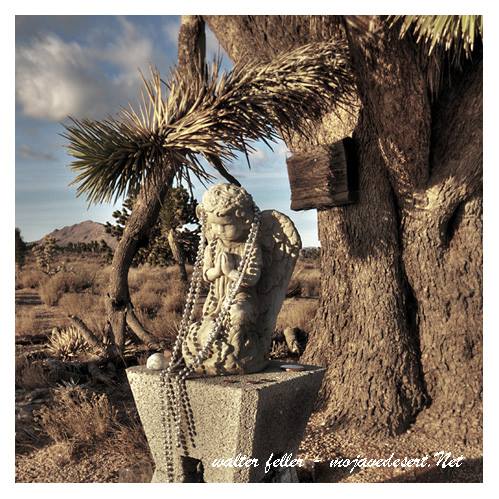
The roadside praying angel is one of those quiet desert mysteries that blend faith, memory, and human expression. It is a small stone carving, rough and straightforward, standing alone near the edge of a road in the Mojave National Preserve. Travelers who find it often notice the small offerings placed at its base—necklaces, coins, stones, or bits of ribbon—tokens left by strangers moved by something they may not fully understand. There are no signs, no plaques, and no explanation for why it is there, only the silent presence of the angel itself.

Its origins are unknown, but that is part of its power. In the desert, where life feels fragile and time seems endless, people have long left markers of their passing. The angel may be a memorial to someone who died nearby, perhaps in an accident along the road. It might also be an act of devotion, a gesture of gratitude, or protection placed by a traveler who felt the desert’s vastness and wanted to acknowledge it. Some might even see it as a roadside shrine, a spot where faith touches the landscape without ceremony or permission.

Whatever its story, the praying angel fits into a long tradition of folk memorials scattered across the Mojave. These handmade symbols are not official monuments or park features; they are personal expressions, born out of loss, love, or awe. They stand where official history ends and personal meaning begins. Each one reminds us that people still reach for the sacred, even in the loneliest places. The stone angel is less a destination than a moment of reflection—a quiet sign that someone cared enough to mark the desert with prayer.

Rare Earths

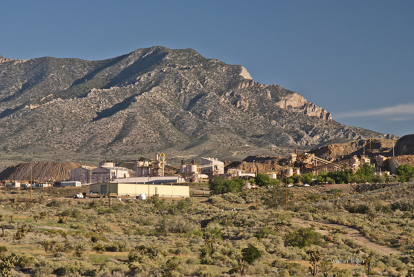
Mountain Pass, California, is an unincorporated community in San Bernardino County near the Nevada border along Interstate 15. It lies on the south flank of the Clark Mountain Range at about 4,730 feet in elevation. Before its transformation into a rare earth mining hub, Mountain Pass was part of a high desert rangeland used for cattle grazing and seasonal travel.

mountain pass rare earths mine

In the late 1800s, ranchers from Ivanpah and the Mojave River region grazed cattle along the area’s sparse grasslands and natural springs. By the early 1900s, a few homesteads, corrals, and line camps appeared, but permanent settlement was limited due to aridity and isolation. The nearest centers of activity were Cima and Ivanpah, tied to the Union Pacific line.

During the 1920s and 1930s, open-range ranching declined as highway construction and mineral exploration expanded. U.S. Highway 91, built through Mountain Pass in the 1930s, connected Barstow and Las Vegas and reshaped movement across the desert. Prospectors began testing local outcrops for copper, fluorspar, and uranium.

In 1949, while searching for uranium, geologists discovered bastnasite—a mineral rich in rare earth elements. By 1952, Mountain Pass Mine was in production, marking the shift from ranching to mineral extraction. The mine’s bastnasite ore, containing about 7% rare-earth oxides, proved exceptionally rich. Throughout the 1960s, 1970s, and 1980s, Mountain Pass supplied most of the world’s rare earth elements, which are critical for electronics and defense.

Environmental concerns and global competition, particularly from China, led to a decline in the 1990s. A series of wastewater pipeline spills and stricter regulations led to the closure in 2002. Molycorp reopened the site in 2010 but went bankrupt in 2015. MP Materials acquired it in 2017 and restarted production, now emphasizing on-site recycling and domestic refining. Mountain Pass currently produces 10–15 percent of global rare earth supply and remains the only major U.S. operation of its kind.

Timeline:

Late 1800s – Early cattle grazing begins between the Clark and Mescal Ranges.
1890s–1910s – Small ranchers and homesteaders establish corrals and wells near Cima and Ivanpah.
1920s – Ranching continues; U.S. Highway 91 construction increases access.
1930s–1940s – Grazing declines; mineral prospecting grows.
1949 – Bastnasite discovered while prospecting for uranium.
1952 – Mountain Pass Mine begins rare earth production.
1960s–1980s – Peak years; mine supplies most of the world’s rare earth elements.
1980s–1990s – Environmental issues and foreign competition led to a decline.
2002 – Mine ceases operations.
2010 – Molycorp reopens the mine.
2015 – Molycorp declares bankruptcy.
2017 – MP Materials resumes production.
2020s – Expansion of domestic processing and magnet manufacturing.

Mountain Pass stands as a symbol of changing desert economies—from open-range cattle country to strategic mineral industry—each era leaving its own traces: windmills, corrals, and open pits scattered across the Mojave’s high desert plain.

Palmenthal

Johann George Ecker led a group of German and Swiss immigrants who settled in the Antelope Valley in 1886, founding a small colony they called Palmenthal—named for the nearby Joshua trees, which they mistook for palms. These settlers sought to establish a self-sufficient farming community on the high desert plain. Drawing from their European roots, they introduced cooperative labor, community organization, and dry-farming methods suited to the arid conditions. Early crops included barley, wheat, and fruit orchards, with irrigation ditches dug by hand to capture scarce water. Despite their determination, drought and isolation made survival difficult, and by the early 1890s, many settlers left. Still, their legacy endured in the renamed settlement of Palmdale, marking the valley’s first organized agricultural community.

Palmenthal was the original German-Swiss settlement that became Palmdale, California. Founded in 1886 by Johann George Ecker and a group of immigrant families from Germany and Switzerland, the colony was located near present-day 20th Street East and Avenue Q. The settlers named it Palmenthal, or “Palm Valley,” after mistaking the native Joshua trees for palms.

They arrived with hopes of building a cooperative farming community, bringing European agricultural practices and traditions with them. Using dry-farming methods, they planted barley, wheat, and fruit orchards, and attempted small-scale irrigation projects to make the desert productive. The settlers built simple homes, a school, and community facilities, establishing the first structured settlement in the Antelope Valley.

Life in Palmenthal was harsh. Repeated droughts, crop failures, and the isolation of the high desert took their toll. Within a few years, many families abandoned the colony, some moving closer to the Southern Pacific Railroad line near Harold, where water and transport were more reliable. By the early 1890s, Palmenthal was largely deserted, but its spirit persisted in the nearby settlement that would evolve into modern Palmdale.

The story of Palmenthal represents the first organized effort to colonize and cultivate the Antelope Valley—an experiment in community and endurance that laid the groundwork for future growth in the region.

Timeline

1886 – Johann George Ecker and a group of German and Swiss immigrants establish the settlement of Palmenthal in the Antelope Valley, naming it for the Joshua trees they mistake for palms.

1887 – The settlers begin dry farming and plant wheat, barley, and fruit orchards. A small schoolhouse and community hall are built.

1888 – Severe drought conditions make farming difficult. Wells yield limited water, forcing the settlers to haul water from distant springs.

1889 – Some families leave the settlement due to crop failures and the isolation of the high desert.

1890 – Remaining settlers attempt to improve irrigation by digging ditches and small reservoirs, but lack of rainfall continues to hinder success.

1891 – The Southern Pacific Railroad establishes a station several miles west, prompting some settlers to relocate closer to the line for better access to supplies and transport.

1892 – Palmenthal is largely abandoned. The remaining residents consolidate around the new rail siding area that becomes known as Palmdale.

1893 – The name Palmdale replaces Palmenthal, marking the transition from the failed colony to the town that would endure.

Colonel Albert G. Boyd

Colonel Albert G. Boyd’s influence on aviation in the Antelope Valley during the 1940s was profound and lasting.

Born in 1906, Boyd joined the Army Air Corps in the 1920s and developed a reputation as both a skilled pilot and a meticulous engineer. When he took command of Muroc Army Air Field in 1945, the base was still a relatively primitive outpost in the Mojave Desert, used primarily for gunnery and bombing practice during World War II. Boyd recognized the potential of the area’s wide, dry lakebeds and clear weather for testing experimental aircraft.

Under his direction, Muroc was reorganized into a formal testing and research facility. Boyd introduced structured engineering methods to flight testing—demanding that pilots follow precise test protocols, record accurate data, and collaborate directly with engineers. This disciplined approach replaced the earlier, more informal trial-and-error methods that had dominated aviation testing.

He personally flew and supervised tests of many of the era’s most advanced aircraft, including the P-80 Shooting Star (the first operational U.S. jet fighter), the XP-84 Thunderjet, and the XP-86 Sabre. Boyd also selected and mentored test pilots who would go on to fame, including Chuck Yeager, who broke the sound barrier in 1947 in the Bell X-1—an event made possible by Boyd’s groundwork in developing a safe, scientific test environment.

By 1949, Muroc had been renamed Edwards Air Force Base, and Boyd became its first commander under the newly formed U.S. Air Force. His influence extended to the creation of the Air Force Test Pilot School, which formalized the training of test pilots and engineers.

Boyd’s leadership established the Antelope Valley as the epicenter of experimental flight, directly shaping America’s Cold War aerospace industry. His legacy earned him induction into the National Aviation Hall of Fame in 1984 and enduring recognition as the “Father of Modern Flight Testing.”

Lockheed

Pearl L. (Allan) Lockheed’s story ties neatly into the larger evolution of aviation in Southern California and the Antelope Valley’s rise as an aerospace center. Here’s a fuller picture of that 1930s connection:

Allan Haines Loughead, who later respelled his name as “Lockheed” to simplify pronunciation, co-founded the original Lockheed Aircraft Company with his brother Malcolm in 1916 in Santa Barbara. Their first successful aircraft, the Model G seaplane, led to several innovative designs before the company went dormant in the 1920s due to financial hardship. In 1926, investor Fred Keeler and engineer Jack Northrop revived the brand as the Lockheed Aircraft Corporation in Hollywood, and by the early 1930s its headquarters had moved to Burbank.

During this period, Lockheed’s engineers were testing high-performance designs that demanded broad, open airfields far from populated areas. The Antelope Valley—with its dry climate, smooth alkali flats, and absence of air traffic—offered perfect conditions. Company pilots, mechanics, and test crews used open tracts near Lancaster and Muroc Dry Lake for proving flights, performance trials, and long-distance endurance runs. Aircraft such as the Lockheed Vega, made famous by pilots like Wiley Post and Amelia Earhart, were occasionally tested in these desert settings to assess handling and engine reliability under extreme heat and dust conditions.

These early desert test flights did more than validate aircraft—they demonstrated the region’s unmatched utility for flight experimentation. Word of the valley’s favorable flying conditions spread quickly through the Southern California aviation community, influencing later government and industry decisions. By the late 1930s, Muroc Dry Lake had been adopted by the Army Air Corps as a training and test site, the foundation of what became Edwards Air Force Base. Lockheed’s early desert work thus helped pave the way—both literally and figuratively—for the Antelope Valley’s transformation into America’s aerospace heartland.

Would you like me to include a short timeline of Lockheed’s Antelope Valley involvement leading up to World War II?

Timeline – Pearl L. (Allan) Lockheed and the Antelope Valley

1916 – Allan and Malcolm Loughead establish the Loughead Aircraft Manufacturing Company in Santa Barbara. They produce innovative seaplanes but struggle financially after World War I.

1926 – The Lockheed Aircraft Corporation is formed in Hollywood by a group of investors who revive the Loughead name and employ engineer Jack Northrop. The company quickly earns a reputation for strong, streamlined aircraft.

1927 – The first Lockheed Vega is built in a small shop in Hollywood. Designed for speed and endurance, it became one of the most successful aircraft of its time.

Late 1920s – Test flights begin taking advantage of Southern California’s wide, dry basins. Open areas north of Los Angeles, including the Antelope Valley, are occasionally used for long-range testing due to their flat terrain and low population density.

1930 – Lockheed relocates to Burbank, expanding production of the Vega, Air Express, and Orion aircraft. Pilots testing these aircraft frequently utilize the high desert for performance runs and navigation trials.

Early 1930s – As aircraft speeds increase and test safety becomes a growing concern, engineers and pilots continue to explore isolated desert fields near Lancaster and Muroc Dry Lake for proving flights. These flights help identify the area’s potential for larger-scale aviation operations.

Mid-1930s – Lockheed’s reputation for precision engineering attracts both private and government attention. The Antelope Valley becomes recognized within aviation circles as an ideal environment for high-speed, high-altitude testing.

1937 – The U.S. Army Air Corps begins using Muroc Dry Lake for training and gunnery practice, laying the foundation for what will become Muroc Army Air Field in 1938. Lockheed’s earlier presence in the area helps establish its suitability for military and industrial testing.

By the end of the 1930s, Lockheed was producing advanced aircraft such as the Model 14 Super Electra, and the Antelope Valley’s airfields were becoming integral to regional aerospace testing. These developments mark the beginning of the desert’s long association with flight research, innovation, and the aerospace industry that would define it in the decades to come.

MojaveDesert.net ↔ Digital-Desert Cross-Linking Table

Core ThemeMojaveDesert.net (Reference Focus)Digital-Desert.com (Visual/Interpretive Focus)Connection Strategy
Geology & LandformsDesert Geology, Mojave Geologic History, Fault SystemsLand Formations, Rainbow Basin, Vasquez Rocks, Blackhawk LandslideLink detailed geology articles to photo galleries and field overviews. Example: “Geology of Rainbow Basin” → “Rainbow Basin Photos & Map.”
Hydrology & Ancient LakesAncient Mojave River, Lake Manix, Harper Lake, Cronese BasinAfton Canyon, Mojave River Corridor, Desert WaterwaysConnect hydrologic analysis to scenic and interpretive summaries. Add timeline overlay linking prehistoric to modern systems.
Ecological SubsectionsNRCS Subsections (M262Bd, M262Bg, etc.), Plant Series GuidesVegetation Zones, Wildlife by Habitat, Ecological Photo SetsCross-tag each subsection to its visual zone (e.g., M262Bd → San Gabriel Mountains photo essay).
Flora & FaunaDesert Plants Database, Animal ProfilesPlant Gallery, Wildlife Slideshow, Trail EcologyEmbed reference species lists with Digital Desert image sets and concise interpretive text.
Indigenous & Prehistoric HistoryNative People of the Mojave, Archaeological Sites, Cultural AdaptationCultural Landscapes, Petroglyph Sites, Oasis LifeLink ethnographic background to interpretive imagery and location-based summaries.
Exploration & TrailsOld Spanish Trail, Mojave Road, Fremont Expeditions, Mormon RoadTrail Maps, Modern Routes, Scenic Drive GuidesMaintain continuity between route chronologies and visual waypoints. Add historic vs. modern overlays.
Pioneer & Settlement HistoryLane’s Mojave River Crossing, Stoddard Wells, Rabbit Springs, Lucerne ValleyHistoric Landmarks, Pioneer Monuments, Photo FeaturesPair archival narrative with photos and topographic context.
Mining & IndustryGreenwater District, Cerro Gordo, Tonopah & Tidewater Railroad, Boron, Tecopa RailroadGhost Towns, Mining Camps, Ruins & Relics, Railroad CorridorsCross-link each district history with its photo tour and modern remains.
Ranching & HomesteadingOld Woman Springs Ranch, Heart Bar Ranch, Kiel Ranch, Apple Valley InnRanch Sites Today, Historic Buildings, Desert Life GalleriesTie historical narratives to current landscapes and adaptive reuses.
National Parks & PreservesJoshua Tree Historic Study (Greene 1983), Mojave National Preserve Admin HistoryPark Highlights, Visitor Centers, Trails & FeaturesUse MojaveDesert.net for resource depth; Digital Desert for park overviews and photography.
Notable FiguresBill Keys, Death Valley Scotty, Sheldon Stoddard, Minerva Hoyt, Albert SwarthoutPioneer Biographies, Interpretive Exhibits, Historic GravesitesInterlink personal histories to regional story hubs and monument pages.
Transportation & CommerceRemi Nadeau Freight Road, Eichbaum Toll Road, Tonopah Junction, Rail NetworksHistoric Routes Map, Highway Overviews, Ghost Rail GradesCreate narrative flow from early transport to modern corridors.
Desert CommunitiesGoodsprings, Tecopa, Lucerne Valley, Barstow, Victorville, Littlerock, PearblossomTown Profiles, Main Street Features, Photographic ToursLink community histories to present-day imagery and context.
Education & InterpretationNatural Science Articles, Chronologies, Historic TimelinesLearning Modules, Short Explanations, Photo EssaysDevelop educational continuity between longform reference and digestible visuals.
Environmental ProcessesClimate, Weather, Wind, ErosionSeasonal Photo Sets, Wildflower Bloom Reports, Weathered Rock FeaturesConnect scientific explanation with real-world observation and photography.

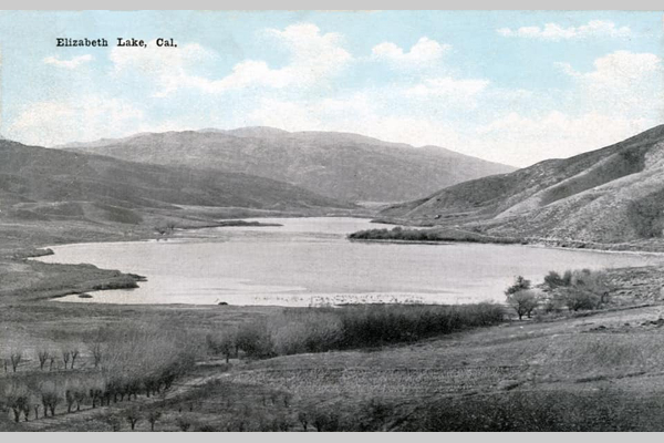
La Laguna de Chico Lopez

Francisco “Chico” Lopez was an early Californio rancher whose name became attached to what is now Elizabeth Lake, once widely known as La Laguna de Chico Lopez.

He was part of the Lopez family that held long-standing land and grazing rights in the western Antelope Valley during the Mexican and early American periods of California. The Lopez holdings were associated with the Rancho San Francisco grant, centered near present-day Newhall. Still, their herds often ranged north and west into the Sierra Pelona and Antelope Valley foothills.

By the 1840s, Chico Lopez was running sheep and cattle in the region surrounding the lake. Travelers and surveyors used his name to identify the landmark—“Chico Lopez’s Lake” or “La Laguna de Chico Lopez.” The lake served as a watering stop along the early trails crossing the San Andreas rift zone between Soledad Canyon and the Antelope Valley.

Later, as American settlers arrived in the 1860s and 1870s, the Lopez name persisted in maps and local speech until the site was renamed Elizabeth Lake. The renaming is attributed to surveyor Benjamin Davis Wilson (Don Benito Wilson), who supposedly named it for a relative or acquaintance during his expeditions through the area.

Though details of Chico Lopez’s later life are scarce, his legacy survives in the early place-name and in the transition from the Californio ranching era to the American homesteading period in the western Mojave frontier.

Elizabeth Lake

Silver Road

Borax Road

Tejon Pass

Fort Tejon Road

Don Benito Wilson

Tiburcio Vasquez

Tejon Ranch (Winter)

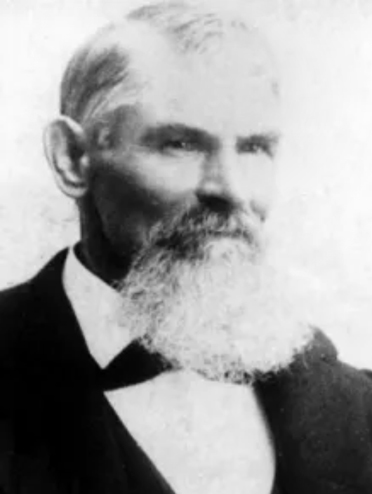
Arvin Stoddard

Arvin Mitchell Stoddard (1825–1914)

Arvin Stoddard

Born in 1825 in Bastard Township, Leeds County, Upper Canada (now Ontario). He was the son of Nathaniel and Jane Stoddard and brother to Sheldon, Albert, and Rufus. The family later converted to Mormonism and joined the westward migration.

Traveled with a Mormon emigrant company under Charles C. Rich around 1852 to 1853. Reached the Salt Lake Valley in Utah, then continued west into California by the mid-1850s, likely entering through Cajon Pass. Settled in the San Bernardino area with other early pioneers.

Moved into the Mojave region during the late 1850s or early 1860s. Established or drilled Stoddard Well, which became a vital water source for travelers. Helped develop the Stoddard Wells Road, an important freight and emigrant route between Victorville and Barstow. Supported freighting operations and ranching efforts in the Victor Valley. Worked closely with his brother Sheldon, who was also active in transportation and settlement.

Stoddard Wells became a lasting geographic landmark and stop along desert routes. The road provided improved access for mining, settlement, and commerce. His work reflected the hands-on pioneer ethic of building essential infrastructure in difficult terrain. Remembered locally as one of the Stoddard brothers, among the earliest trailblazers of the Mojave Desert.

Remained in Southern California into the late 19th century. Died in 1914. His name endures through landmarks like Stoddard Wells, which commemorate his role in opening the Mojave to travel and settlement.

Arvin’s story illustrates the shift from Mormon settlement to broader regional development across Southern California. His contributions supported the growing network of trails, roads, and water sources that made desert travel possible. He stands as an example of the practical, industrious pioneers who built the foundation for future desert communities.

Sheldon Stoddard
Early pioneer and Mormon settler who helped establish routes, wells, and communities along the Mojave River during California’s frontier expansion.

Upper Mojave River Trail
Historic travel corridor following the upper Mojave River, connecting early settlements, ranches, and stage stops between Cajon Pass and Barstow.

Stoddard Wells Road
Historic wagon route branching from the Mojave River Trail, used by settlers and freighters linking San Bernardino with desert mining districts.

Stoddard Well
A vital water source established by the Stoddard brothers and later maintained by Hiram Hartman, serving travelers and stockmen crossing the high desert.

Pioneers
Early settlers who braved the Mojave frontier, building wells, trails, and communities that shaped the foundation of inland Southern California.

San Bernardino
Regional center and supply hub for Mormon settlers and desert pioneers, serving as gateway to the Mojave and points east during westward expansion.

Fish Ponds
Artificial ponds along the Mojave River near Stoddard Wells, providing food and water resources for ranchers and travelers in the arid landscape.

Mormon Crossing
Historic Mojave River ford near present-day Victorville, used by Mormon pioneers and freighters traveling between San Bernardino and Salt Lake City.

Mojave River
An intermittent desert river flowing underground much of its course, sustaining life, travel, and settlement along California’s inland frontier.