Mule Skinner

/death-valley-history/skinner.html

Introduction

The mule skinner was a skilled tradesman who specialized in working with mules. Their job was to maintain and care for the animals, as well as harness them for tasks such as pulling carts or carrying loads. Mule skinners had a unique set of skills that were essential for the successful operation of various agricultural and transportation industries.

Responsibilities

1. Caring for the Animals: Mule skinners were responsible for the daily care and maintenance of mules. This included grooming, feeding, and watering them, as well as providing any necessary medical attention. They also ensured that the mules were properly shod and fit for work.

2. Harnessing and Driving: One of the key duties of a mule skinner was to harness the animals for the task at hand. They needed to know the correct placement of harness and straps to ensure the safety and comfort of the mules. Mule skinners also drove the mules using a variety of methods, such as using a whip or voice commands.

3. Teamster: Mule skinners were often employed as teamsters, leading teams of mules in tasks such as pulling carts or carrying loads. They needed to know how to manage a team of mules, keeping them coordinated and working together efficiently.

4. Maintenance and Repair: Mule skinners were responsible for maintaining the mules’ equipment and keeping everything in good working order. This included repairing harnesses, mending cart wheels, and other tasks to ensure the mules’ safety and productivity.

5. Safety and Security: Mule skinners had to ensure the mules’ safety and security at all times. They needed to be aware of the potential dangers on the road and take precautions to prevent accidents or injury to the animals.

Skills and Qualifications

To become a mule skinner, individuals typically had to possess certain skills and qualifications. These may include:

– Technical Knowledge: Mule skinners needed to know the anatomy and behavior of mules, as well as the best methods for harnessing and driving them. They also needed to possess knowledge of mule breeding and veterinary care.

– Leadership and Communication: Mule skinners had to be good leaders, able to effectively communicate with a team of mules and other drivers. They needed to be able to calm animals when agitated and guide them safely through challenging situations.

– Physical Strength and Endurance: Mule skinners needed to possess physical strength and endurance to work long hours in physically demanding conditions. They needed to be able to handle the mules and harness them, as well as assist in loading and unloading carts or wagons.

– Problem-Solving Skills: Mule skinners often encountered unexpected situations and had to think on their feet. They needed problem-solving skills to quickly assess situations and make sound decisions to ensure the safety and well-being of the mules.

Conclusion

The mule skinner was a skilled tradesman who played a significant role in various industries that rely on mules. Their job was to care for and maintain the animals, harness them for work, and drive them effectively. Mule skinners had a unique set of skills that allowed them to successfully handle mules and contribute to the success of various agricultural and transportation operations.

Borax Wagons

The 20-mule team borax ore wagons used in the late 1800s to transport borax from the mines in Death Valley, California, were quite large and had specific dimensions.

Here are the approximate dimensions for a typical 20-mule team borax ore wagon:

  1. Length: Approximately 30 feet (9 meters)
  2. Width: About 8 feet (2.4 meters)
  3. Height: Around 7 feet (2.1 meters)
  4. Weight: These wagons weighed approximately 7 tons when fully loaded with borax ore.

These massive wagons required a team of 18 mules and two horses to pull them across the harsh desert terrain. They were an iconic part of the borax mining industry in the late 19th century and were crucial in transporting borax to the nearest railroad for distribution.

  1. Two large ore wagons were used to transport the borax ore from the mines in Death Valley to the nearest railroad for shipment. They were massive and could carry a significant amount of borax.
  2. One water tank wagon: There was a specialized tank wagon in addition to the two ore wagons. This wagon carried water for the mules and horses that pulled the wagons. The desert environment of Death Valley was harsh, and providing water for the animals was crucial to their survival during the long and arduous journey.

So, the 20-mule team borax wagons actually consisted of 18 mules and 2 horses pulling two ore wagons and one water tank wagon. These wagons became an iconic symbol of the borax mining industry in the late 19th century.

Borax

20-Mule Teams

Harmony

The Lost Breyfogle Mine

The most famous lost mine in the Death Valley area is the Lost Breyfogle. There are many versions of the legend, but all agree that somewhere in the bowels of those rugged mountains is a colossal mass of gold, which Jacob Breyfogle found and lost.

Mesquite Flats Sand Dunes - Death Valley
Mesquite Flats Sand Dunes – Death Valley

Jacob Breyfogle was a prospector who roamed the country around Pioche and Austin, Nevada, with infrequent excursions into the Death Valley area. He traveled alone.

Indian George, Hungry Bill, and Panamint Tom saw Breyfogle several times in the country around Stovepipe Wells, but they could never trace him to his claim. When followed, George said, Breyfogle would step off the trail and completely disappear. Once George told me about trailing him into the Funeral RangeHe pointed to the bare mountain. “Him there, me see. Pretty quick—” He paused, puckered his lips. “Whoop—no see.”

Breyfogle left a crude map of his course. All lost mines must have a map. Conspicuous on this map are the Death Valley Buttes which are landmarks. Because he was seen so much here, it was assumed that his operations were in the low foothills. I have seen a rough copy of this map made from the original in possession of “Wildrose” Frank Kennedy’s squaw, Lizzie.

Breyfogle presumably coming from his mine, was accosted near Stovepipe Wells by Panamint Tom, Hungry Bill, and a young buck related to them, known as Johnny. Hungry Bill, from habit, begged for food. Breyfogle refused, explaining that he had but a morsel and several hard days’ journey before him. On his burrhe had a small sack of ore. When Breyfogle left, Hungry Bill said, “Him no good.”

Incited by Hungry Bill and possible loot, the Indians followed Breyfogle for three or four days across the range. Hungry Bill stopped en route, sent the younger Indians ahead. At Stump Springs east of ShoshoneBreyfogle was eating his dinner when the Indians sneaked out of the brush and scalped him, took what they wished of his possessions and left him for dead.

Ash Meadows Charlie, a chief of the Indians in that area confided to Herman Jones that he had witnessed this assault. This happened on the Yundt Ranch, or as it is better known, the Manse Ranch. Yundt and Aaron Winters accidentally came upon Breyfogle unconscious on the ground. The scalp wound was fly-blown. They had a mule team and light wagon and hurried to San Bernardino with the wounded man. The ore, a chocolate quartz, was thrown into the wagon.

Resting Springs Ranch - Old Spanish Trail, Mormon Road
Resting Springs

“I saw some of it at Phi Lee’s home, the Resting Spring Ranch,” Shorty Harris said. “It was the richest ore I ever saw. Fifty pounds yielded nearly $6000.”

Breyfogle recovered, but thereafter was regarded as slightly “off.” He returned to Austin, Nevada, and the story followed.

Wildrose (Frank) Kennedy, an experienced mining man obtained a copy of Breyfogle’s map and combed the country around the buttes in an effort to locate the mine. Kennedy had the aid of the Indians and was able to obtain, through his squaw Lizzie, such information as Indians had about the going and coming of the elusive Breyfogle.

“Some believe the ore came from around Daylight Springs,” Shorty said, “but old Lizzie’s map had no mark to indicate Daylight Springs. But it does show the buttes and the only buttes in Death Valley are those above Stovepipe Wells.

“Kennedy interested Henry E. Findley, an old time Colorado sheriff and Clarence Nyman, for years a prospector for Coleman and Smith (the Pacific Borax Company). They induced Mat Cullen, a rich Salt Lake mining man, to leave his business and come out. They made three trips into the valley, looking for that gold. It’s there somewhere.”

Francis Marion "Borax" Smith
Francis Marion “Borax” Smith

At Austin, Breyfogle was outfitted several times to relocate the property, but when he reached the lower elevation of the valley, he seemed to suffer some aberration which would end the trip. His last grubstaker was not so considerate. He told Breyfogle that if he didn’t find the mine promptly he’d make a sieve of him and was about to do it when a companion named Atchison intervened and saved his life. Shortly afterward, Breyfogle died from the old wound.

Indian George, repeating a story told him by Panamint Tom, once told me that Tom had traced Breyfogle to the mine and after Breyfogle’s death went back and secured some of the ore. Tom guarded his secret. He covered the opening with stone and leaving, walked backwards, obliterating his tracks with a greasewood brush. Later when Tom returned prepared to get the gold he found that a cloudburst had filled the canyon with boulders, gravel and silt, removing every landmark and Breyfogle’s mine was lost again.

“Some day maybe,” George said, “big rain come and wash um out.”

Among the freighters of the early days was John Delameter who believed the Breyfogle was in the lower Panamint. Delameter operated a 20 mule team freighting service between Daggett and points in both Death Valley and Panamint Valley. He told me that he found Breyfogle down in the road about twenty-eight miles south of Ballarat with a wound in his leg. Breyfogle had come into the Panamint from Pioche, Nevada, and said he had been attacked by Indians, his horses stolen, while working on his claim, which he located merely with a gesture toward the mountains.

Subsequently, Delameter made several vain efforts to locate the property, but like most lost mines, it continues to be lost. But it was good bait for a grubstake for years and served both the convincing liar and the honest prospector.

Nearly all old timers had a version of the Lost Breyfogle differing in details, but all agreed on the chocolate quartz and its richness.

That Breyfogle really lost a valuable mine, there can be little doubt, but since he is authentically traced from the northern end of Death Valley to the southern, and since the chocolate quartz is found in many places of that area, one who cares to look for it must cover a large territory.

From: Chapter XXII
Lost Mines. The Breyfogle and Others
Loafing Along Death Valley Trails by William Caruthers

Charles Brown at Greenwater

From “Loafing Along Death Valley Trails” by William Caruthers

Charles Brown General Store - Shoshone, Ca.
Charles Brown General Store – Shoshone, Ca.

The story of Charles Brown and the Shoshone store begins in Greenwater. In the transient hordes of people that poured into that town, there was one who had not come for quick, easy money. On his own, since he was 11 when he had gone to work in a Georgia mine, he only wanted a job. And he got it. In the excited, loose-talking mob, he was conspicuous because he was silent, calm, and unhurried.

There were no law enforcement officers in Greenwater.  The jail was 150 miles away. Every day was a field day for the toughs in the town. Better citizens decided to do something about it. They petitioned George Naylor, Inyo County Sheriff at Independence, to appoint or send a deputy to keep some semblance of order.

Naylor sent over a badge and a note that said, “Pin it on some husky youngster, who is unmarried and unafraid, and tell him to shoot first.”

The Citizens’ Committee met. ” I know a fellow who answers that description,”  one of them said. ” Steady sort. Built like a panther. Comes from Georgia. Kind slow motion in till he is ready to spring. Name is Brown.”

The badge was pinned on Charles Brown.

Charles & Stella Brown

Greenwater was a port of call for Death Valley Slim, a character of the Western deserts, who normally was a happy-go-lucky likable fellow. Periodically Slim would fill himself with desert “likker”,  his belt with six guns and terrorized the town.

Shortly after Brown assumed the duties of his office, Slim sent word to the deputy that he was on his way to that place for a little frolic. ” Tell him, ”  he coached

Shortly after Brown assumed the duties of his office, Slim sent word to the deputy that he was on his way to that place for a little frolic. ” Tell him, ”  he coached the messenger, “Sheriffs rile me and he better take a vacation.”

After notifying the merchants and residents, who promptly barricaded themselves indoors, the officer found shelter for himself in Beatty, Nevada.

So Slim only saw empty streets and barge shutters upon arrival.  Since there was nothing to shoot at, he headed through Dead Mead Canyon for Greenwater.  their he found the main street crowded to his liking and the saloons jammed. He made for the nearest, ordered a drink and, whipping out his gun, began to pop the bottles on the shelves. At first blast, patrons made a break for the exits. At the second, the doors and windows were smashed and when Slim holstered his gun, the place was a wreck.

Messengers were sent for Brown, who was at his cabin a mile away. Brown’s stuck a pistol in his pocket and went down. He found Slim in Waddell’s saloon, the town’s smartest.  their Slim had refused to let the patrons leave with the bartenders cowed, the patrons cornered, Slim was amusing himself by shooting alternately at chandeliers, the feet of customers, and the plump breasts of the nude lady featured in the painting behind the bar.  following Brown at a safe distance, was half of the population, keyed for the massacre.

Brown walked in and said “Hello Slim”. ” Fellows tell me you  are hogging all the fun. Better let me have that  gun, hadn’t you?” “Like hell,” Slim sneered, ” I’ll let you have it right through the guts.”

As he raised his gun for the kill, the panther sprung  and the battle was on.  they fought one over the bar room –  standing up, laying down, rolling over –  first one, then the other on top. Tables toppled, chairs crashed. For half an hour they battled savagely, finally rolling against the bar –  both mauled and bloody. There, with his strong vice-like legs wrapped around Slim’s and in arm of steel gripping net and shoulder, Brown slipped irons over the bad man’s wrist. ” Get up,”  Brown ordered as he stood aside, breathing hard.


Greenwater, Ca. ghost town site, Death Valley National Park

Slim rose, leaned against the bar. There was fight still in him and seeing a bottle in front of him, he had seized it with manacled hands, started to lift it.

” Slim,”  Brown said calmly , ” if you lift that bottle, you’ll never lift another.”

The bad boy instinctively knew the look that foretells death and Slim’s fingers fell from the  bottle.

Greenwater had no jail. Brown took him to his own cabin. Leaving the manacles on the prisoner, he took off his shoes and locked  him in a closet.  no man, drunk or sober, he reflected, would tackle barefoot the gravel street littered with thousands of broken liquor bottles.  He went to bed.

He left a bloodstained trail, but at 2 AM he found Slim in a blacksmith shop, having the handcuffs removed. Brown retrieved his shoes and on the return trip, Slim went barefoot. After hog tying the prisoner, Brown chained  him to the bed and went to sleep.

Thereafter, the bad boys scratched Greenwater off their calling list.

Slim attained fame with  Pancho Villa down in Mexico,  became a good citizen and later went east.

-~

Panamint Valley

/panamint-valley/

Panamint Valley is a desert valley located in eastern California within the northern Mojave Desert. It is situated between the Inyo Mountains to the west and the Panamint Range to the east. The valley is part of Inyo County and is known for its arid landscape and unique geological features.

Here’s a brief overview of the history of Panamint Valley:

  1. Native American Presence: The area around Panamint Valley has a history of Native American occupation dating back thousands of years. Various Native American groups, including the Timbisha Shoshone, lived in the region, relying on the desert environment for sustenance.
  2. Exploration and Settlement: In the mid-19th century, European-American explorers and settlers began to venture into the area. The valley was part of the route used by pioneers during the California Gold Rush. However, the harsh desert conditions made permanent settlement challenging.
  3. Mining Boom: The late 19th and early 20th centuries saw a mining boom in the surrounding mountains. The Panamint Range, especially, was rich in minerals like silver and lead. Towns such as Ballarat and Panamint City sprang up to support mining activities. Panamint City, in particular, was once a thriving mining town with a peak population of around 2,000 people.
  4. Decline of Mining: As mining operations became less profitable, many of the towns in the region, including those in Panamint Valley, experienced a decline and were eventually abandoned. By the mid-20th century, the mining industry in the area had significantly diminished.
  5. Military Presence: During World War II, the U.S. military established a presence in the Mojave Desert, including around Panamint Valley. The China Lake Naval Weapons Center, now known as the Naval Air Weapons Station China Lake, was established southeast of the valley. The military presence in the region has continued to the present day.
  6. Recreational Activities: In recent times, Panamint Valley has become a destination for outdoor enthusiasts, including hikers, off-road vehicle enthusiasts, and nature lovers. The valley’s unique geological features, such as the Panamint Dunes, attract visitors interested in exploring the desert landscape.

Panamint Valley remains a sparsely populated and remote area known for its historical significance, geological features, and recreational opportunities.

Is Death Valley in the Mojave Desert?

Death Valley is part of the Mojave Desert. Death Valley is a desert valley located in Eastern California and a small part of Nevada in the United States. It is one of the hottest places on Earth and holds the record for the highest air temperature ever recorded, which reached 134 degrees Fahrenheit (56.7 degrees Celsius) in Furnace Creek Ranch on July 10, 1913.

The Mojave Desert is a vast desert in the southwestern United States, primarily in southeastern California, southern Nevada, and parts of Arizona and Utah. It is the driest desert in North America and is known for its arid landscapes, unique plant and animal life, and iconic features like Joshua Tree National Park.

Death Valley is situated within the Mojave Desert, and the two are often mentioned together due to their geographic proximity and shared arid climate characteristics.

Scotty

“Death Valley” Scotty, whose full name was Walter E. Scott, was a colorful and legendary figure associated with Death Valley, a desert valley located in Eastern California. Scotty gained fame in the early 20th century for his claims of owning a gold mine in Death Valley and for his flamboyant personality.

Scotty’s story is closely tied to his relationship with wealthy Chicago businessman Albert Johnson. In the early 1900s, Scotty convinced Johnson to invest in his supposed gold mine, even though there was little evidence to support the existence of significant gold deposits. Despite the skepticism of others, Johnson continued to finance Scotty’s ventures, and the two became unlikely friends.

With his charismatic and theatrical personality, Scotty became a well-known character, and his antics and stories helped attract attention to Death Valley. He was known for his cowboy attire, tall tales, and his ability to charm people.

Scotty’s gold mine claims were largely exaggerated, and there is little evidence that he ever discovered a significant amount of gold. The financial arrangement between Scotty and Johnson remained a subject of speculation and mystery.

After Johnson died in 1948, it was revealed that much of the financing had come from Johnson himself, and Scotty had not been as successful in the mining business as he claimed. Despite the deceptive aspects of his story, Scotty remained a beloved figure in Death Valley folklore, and his former home, Scotty’s Castle, is a popular tourist attraction in Death Valley National Park.

The legacy of “Death Valley” Scotty is a mix of fact and fiction, blending the mystique of the Old West with a touch of showmanship and exaggeration.

Leadfield – Summary

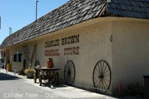
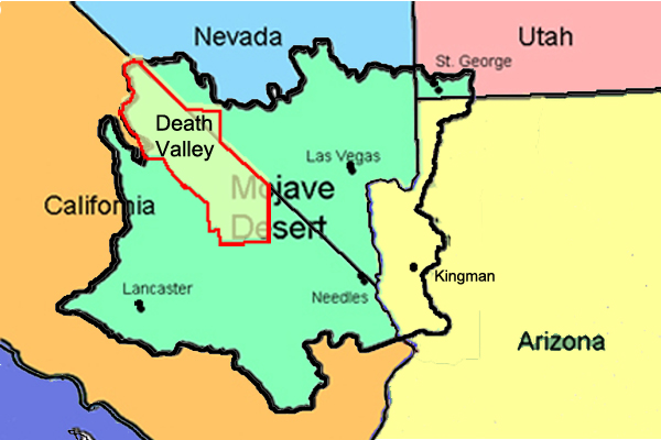
https://mojavedesert.net/mining-history/leadfield/index.html

Leadfield, located in Titus Canyon, was promoted by a man who could have sold ice to an Eskimo. He blasted some tunnels and liberally salted them with lead ore and drew up some enticing maps of the area, which lured Eastern promoters into investing money.

The true story of Leadfield is somewhat different from the usual tale of a stock swindle and a dying town.

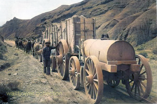
During the early days of the Bullfrog boom, W. H. Seaman and Curtis Durnford staked nine lead and copper claims in Titus Canyon and came into Rhyolite with ore samples that assayed as high as $40 to the ton. The Death Valley Consolidated Mining Company was incorporated and immediately began a development and promotional campaign.

The Death Valley Consolidated Mining Company ceased operations in 1906 after realizing that the long and arduous trip between its mine and Rhyolite made the shipment of its ore absolutely unprofitable.

In 1924, three prospectors staked out numerous claims on some lead deposits in Titus Canyon. A local promoter named John Salsberry purchased twelve claims from the three prospectors and formed the Western Lead Mines Company.

The young camp was entering the boom stage, and by January 30th, half a dozen mining companies were in operation. The stock of Western Lead Mines Company soared to $1.57 per share.

Eastern California, and especially Inyo County, was long overdue for a mining boom. With the backing of a successful and skilled promoter, Leadfield seemed assured of obtaining the necessary financial support to take it from a prospecting boom camp into a producing mine town.

The Inyo Independent greeted Julian with a glowing description of his character and abilities, but a different endorsement would be printed in later years.

The boom was now on in earnest, with the Western Lead Company employing 140 men and the Titus Canyon Road being completed. The Western Lead Mine produced 8% to 30% lead and seven ounces of silver per ton.

The California State Corporation Commission was not so impressed with the company and raised the righteous indignation of local folk. The local attitude was well summed up by the Owens Valley Herald: “The Commission is using its every endeavor to try and prejudice the people against this latest promotion of Julian’s.”

The paper pointed out that Julian was not trying to swindle anyone and that he had publicly invited any reputable mining engineer worldwide to visit the Leadfield District. The paper concluded that the future of Leadfield seemed very bright.

Julian was not the only promoter singing the praises of the Leadfield District, for numerous other companies were also trying to cash in on the boom. The Western Lead Mines Company, Julian’s pet, led the pack, with one of its tunnels six hundred feet inside the mountain.

The town of Leadfield was trying to keep pace with the boom and announced that a large hotel would soon be built. On March 15th, the first of Julian’s promotional excursions pulled into Beatty, and 340 passengers were served a sumptuous outdoor feast by the proprietor of the local Ole’s Inn.

Lieutenant-Governor Gover of Nevada gave the keynote speech, and Julian gave a speech praising Julian for overcoming the numerous obstacles that modern governmental bureaucracies put in a man’s path. The trip was a big success, and Western Lead stock advanced 25 on the San Francisco market the next day.

Western Lead stock had soared to $3.30 a share by the end of March, and several ore-buying and smelting concerns sent representatives to the district to discuss reduction and smelting rates.

Leadfield continued to develop in the months following the great train excursion. New mining companies opened for business, and the Tonopah & Tidewater Railroad replied that definite plans for a railroad spur into Leadfield had not been made as the present business does not warrant its construction.

The townsite of Leadfield was officially surveyed on April 30th, and the town’s plat was submitted to Inyo County officials for approval. The town was platted on land donated by the Western Lead Company.

The State of California was breathing hard upon Julian’s neck, and the Corporation Commission hauled a brokerage company into court for selling Western Lead stock without a state permit. Expert witnesses testified that the Western Lead Mine was a quite legitimate proposition.

The continued investigations by the state of California hurt the sales of Western Lead stock, and another factor began to take a toll. Julian’s credibility began to shrink, and the company never recovered from the panic that set in.

Julian bought into the New Roads Mining Company, which gave him control of the two largest mines of Leadfield and announced plans to construct a large milling plant at Leadfield.

As summer approached, the Leadfield boom showed no signs of peaking. The California Corporation Commission ordered that sales of Julian’s personal stock in the Western Lead Mines must immediately cease on the Los Angeles stock exchange due to evidence introduced at a hearing.

Despite the heavy blow to Julian’s financial fortunes, developments at Leadfield proceeded, and the Mining Journal printed a long, detailed report on the Leadfield District in July, which helped to restore public confidence.

The mines agreed with the independent experts and continued to work, and the Boundary Cone Mining Company ordered a new 25-horsepower hoist and headframe and increased its workforce to twelve miners.

In late July, the Western Lead Mining Company brought a $350,000 damage suit against the Los Angeles Times and the California Corporation Commission. Still, the suit was quickly thrown out of court for insufficient cause. In August, a new mining company, the Pacific Lead Mines No. 2, was incorporated.

During September and October, drilling and tunneling continued in Leadfield’s mines, but in late October, two events took place that spelled the end of Leadfield. The main tunnel of the Western Lead Mine finally penetrated the ledge but found almost nothing.

At almost the same time, the California Corporation Commission dealt Julian another blow when it halted stock sales in the Julian Merger Mines, Inc. Julian’s empire fell apart. The other mines slowly closed, one after the other, and Leadfield became a ghost town in a matter of months.

The failure of a mining district led to a flurry of lawsuits. In February of 1927, the Western Lead Company removed its heavy machinery and the pipeline to a mine that the company owned in Arizona.

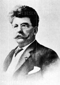
Julian went on to organize the Julian Oil and Royalties Company and was indicted for fraud, but jumped bail and committed suicide.

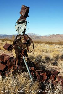
Leadfield was a ghost town created by C. C. Julian. Still, the existence of lead ore in the district had been known as far back as the Bullfrog boom days of 1905, and the California Corporation Commission allowed companies other than Julian’s to sell their stock.

Julian did not start the Leadfield boom and had plenty of help in supporting the boom once it had started. The citizens of Inyo County, California, and Nye County, Nevada, also supported the mines.

The collapse of Julian’s financial structure came at the worst possible time for Leadfield. Although it seems doubtful that Leadfield had enough ore to support more than a small mining company or two, indications are that without the sudden panic of the fall of 1926, that mine or two could have survived.

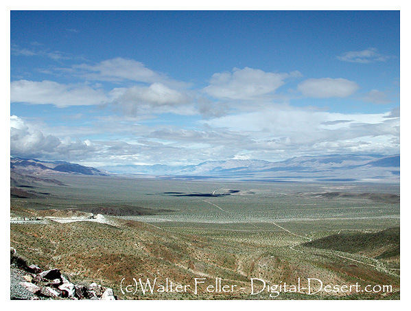
The Titus Canyon Road, an engineering marvel, was built by Julian and cost an estimated $60,000 to build. Without Julian, the road would not have been finished, and today presents one of the most spectacular routes in Death Valley National Park.

Ecosystems of Death Valley

https://digital-desert.com/death-valley-ecosystems/

Death Valley, located in California, is home to a unique and diverse range of ecosystems. Despite its harsh and extreme conditions, this national park supports a surprising variety of plant and animal life. The following are some of the key ecosystems found within Death Valley.

1. Desert Scrub: The dominant ecosystem in Death Valley is the desert scrub, characterized by sparse vegetation and rocky landscapes. Plants such as creosote bushes, desert holly, and Joshua trees have adapted to survive in arid conditions. These plants have deep root systems and waxy leaves to conserve water.

2. Salt Flats: Death Valley is famous for its vast salt flats, known as playas. These white, barren expanses are created by water evaporation, leaving behind mineral deposits. Certain organisms, such as salt-tolerant algae and brine flies, can survive in this environment despite harsh conditions.

3. Badlands: Death Valley’s rugged badlands are formed by erosion, resulting in unique formations of clay-rich soil and sedimentary rocks. The lack of vegetation allows intricate geological formations. These areas are home to reptiles, rodents, and insects that have adapted to extreme temperatures and water scarcity.

4. Oasis: Death Valley surprises visitors with small oases. These are areas where underground water reaches the surface, creating a lush and vibrant habitat. Palm, cottonwood, and various bird species can be found in these isolated pockets of life.

5. Mountains: Death Valley is surrounded by mountain ranges, which provide a contrasting ecosystem to the desert below. These higher elevations offer cooler temperatures and more precipitation, allowing for the growth of coniferous forests. Pinyon pines, junipers, and bristlecone pines thrive in the mountains, providing shelter for various wildlife.

6. Springs and Waterways: Death Valley is home to several natural springs and waterways despite the desert environment. These water sources attract diverse animals, including bighorn sheep, coyotes, and reptiles. The presence of water also supports vegetation growth, such as willows and cattails.

Each of these ecosystems within Death Valley contributes to the region’s overall biodiversity and ecological balance. The park’s extreme conditions have fostered the development of unique adaptations among its plant and animal inhabitants. Exploring these diverse ecosystems is a captivating experience that highlights the resilience of life in the face of adversity.

China Ranch

https://digital-desert.com/china-ranch/

China Ranch is a small oasis nestled near the vast expanse of Death Valley in California. Located just a few miles from the eastern entrance of the national park, it offers a unique and picturesque destination for visitors to explore.

The ranch is renowned for its date farm, which spans over 1,200 acres and produces delicious dates. Dating back to the late 1800s, the farm has operated for several generations and continues to thrive today. Visitors can take guided tours to learn about dates’ history, cultivation, processing, and even sample delectable products.

In addition to the date farm, China Ranch boasts scenic hiking trails that wind through stunning landscapes, such as narrow canyons and towering cliffs. The trails offer breathtaking views of the surrounding desert and provide opportunities to spot unique plant and animal species adapted to the harsh environment.

For those seeking a peaceful retreat, China Ranch offers cozy accommodations in the form of rustic cottages and a charming bed and breakfast. Visitors can relax in the tranquil atmosphere, surrounded by lush gardens and the soothing sounds of nature.

One of the highlights of a visit to China Ranch is exploring the Amargosa River, a rare water source in the arid region. The river meanders through the ranch, providing a refreshing respite from the desert heat. Visitors can enjoy leisurely walks along the riverbanks or birdwatching.

China Ranch is not only a place of natural beauty but also a cultural treasure. The ranch is steeped in history, with remnants of its past visible in the form of old buildings and artifacts. It offers a glimpse into the lives of the early settlers who sought refuge in this secluded oasis.

In conclusion, China Ranch in Death Valley is a hidden gem that offers a unique experience for nature lovers, history enthusiasts, and those seeking a serene escape from the hustle and bustle of daily life. Its stunning landscapes, delicious dates, and rich history make it a destination worth exploring.