In the summer of 1845, Benjamin D. Wilson, who owned part of the interest in the Jurupa Rancho, the site of the present city of Riverside, led a troop of Calvary in search of cattle rustlers.
Setting out from San Bernardino Valley, he divided his command. Most of the men he sent through Cajon Pass, keeping only 22 Mexican troopers with him to follow a trail across the mountains. Two days later, Wilson and his men reached the lake, where they sighted scores of grizzly bears.
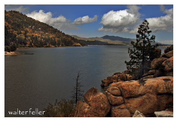
Big Bear Lake
Most of the soldiers had been vaqueros. They formed in pairs and drew reatas, each pair attacking a bear. One looped a rope around the bear’s neck; his companion roped the same bear by a hind foot. Then, the men drew apart to stretch the rope taut and hold the bear a prisoner. They bagged and skinned eleven bears, stretched their hides, and continued across the mountains to join the rest of the command on the desert at Rancho Las Flores, on the Mojave River.
Here, the reunited party engaged Indians in a fight, after which Wilson and his 22 vaquero-troopers returned home by the lake. They again found the place overrun with bears, and the same 22 soldiers brought in eleven more bears—enough to give them a bear rug apiece as a trophy. It was then that Wilson gave the little body of water the name Bear Lake.
Years later, the name was changed to Baldwin Lake. The name survives, however, in Big Bear Lake, which was created at the site of the Talmadge Ranch in 1884, when a dam was built to provide a constant water supply for the Redlands District.
– Adapted from ~ Pioneer Tales of San Bernardino County – WPA – 1940.
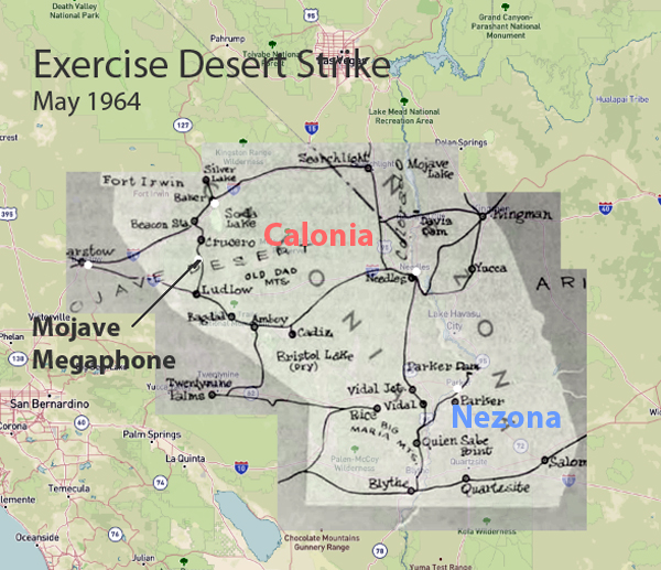
In May 1964, the United States conducted Exercise Desert Strike, one of the most extensive military exercises during the Cold War. It involved over 100,000 military personnel. The primary objectives were to evaluate operational readiness, test conventional and nuclear forces integration, and improve command and control capabilities. The exercise was carried out in multiple phases, beginning with conventional warfare tactics and escalating to simulated nuclear warfare. This tested the troops’ adaptability and response to high-stress scenarios.
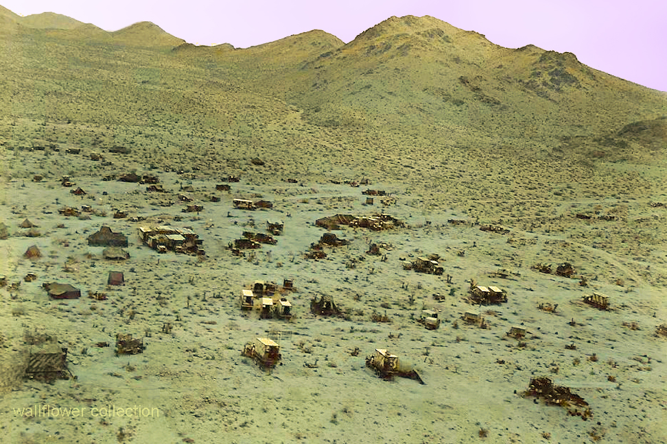
Remote Calzona Camp – Colorized
Despite meticulous planning and rigorous training, the exercise was marred by the tragic loss of 24 men. This underscores the inherent dangers and high stakes of large-scale military operations.
Map showing war zone
Key outcomes of Exercise Desert Strike included a comprehensive assessment of the U.S. military’s strengths and weaknesses. In addition, it validated cutting-edge technologies and significantly improved communication and nuclear warfare strategies. The exercise profoundly impacted subsequent military strategies, contributing to Cold War-era defense policies and nuclear deterrence.
Exercise Desert Strike remains a crucial event in armed forces history, highlighting the importance of preparedness and realistic training in maintaining national security. This exercise’s legacy continues to influence military planning and operations, proving the critical role military exercises have in safeguarding the nation. The fatalities during the exercise are a poignant reminder of the sacrifices made to pursue military excellence and national security.
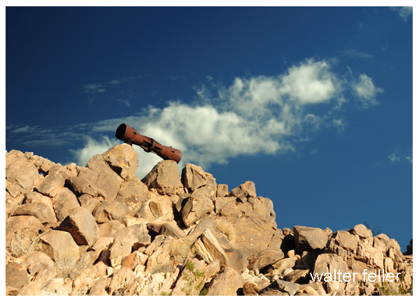
A lasting relic of this period is a megaphone mounted on a rocky hill, symbolizing Exercise Desert Strike’s monumental legacy. This relic is a powerful reminder of the sacrifices necessary to defend our beautiful country. It represents the enduring commitment to national defense and the high price of freedom. It embodies the spirit of vigilance and dedication that inspires and guides military preparedness and strategic planning today.
The Pacific Crest Trail (PCT), stretching over 2,650 miles from Mexico to Canada, offers hikers an unparalleled experience of diverse landscapes and challenging terrains. One of the captivating sections of this trail is the journey from Cajon Pass to Wrightwood in Southern California. This 27-mile segment within the San Gabriel Mountains presents an invigorating mix of natural beauty, physical challenge, and serene solitude.
Setting Out from Cajon Pass
Cajon Pass, located at an elevation of approximately 3,000 feet, marks the starting point for many hikers embarking on this segment of the PCT. The pass, intersected by major highways and railroads, is a bustling gateway to the wilderness beyond. As hikers leave behind the urban cacophony, they are greeted by the rugged charm of the San Bernardino National Forest.
The initial ascent from Cajon Pass is gradual, allowing hikers to acclimate to the elevation change while enjoying sweeping views of the surrounding valleys. This portion of the trail is characterized by its diverse flora, ranging from chaparral shrubs to the majestic Jeffrey pines. Wildlife sightings, including mule deer and various bird species, are common, offering a glimpse into the region’s rich biodiversity.
Climbing into the San Gabriels
As the trail progresses, the terrain becomes increasingly challenging, with steeper inclines and rocky paths. Hikers often find themselves navigating narrow switchbacks that test their endurance and resolve. However, the reward for this effort is the breathtaking vistas that unfold at higher elevations. The panoramic views of the Mojave Desert to the north and the Los Angeles Basin to the south are nothing short of spectacular.
One of the notable landmarks along this stretch is Silverwood Lake, a man-made reservoir that provides a refreshing respite for weary travelers. The lake’s shimmering waters, set against the backdrop of rolling hills, create a picturesque scene that beckons hikers to pause and rejuvenate. This area is also a popular spot for camping, offering a chance to experience the tranquility of the wilderness under a starlit sky.
Approaching Wrightwood
The final leg of the journey to Wrightwood is marked by a gradual descent into the quaint mountain town. Wrightwood, situated at about 6,000 feet, is a welcoming destination for PCT hikers. The town’s rustic charm, friendly residents, and well-stocked amenities provide a much-needed break from the rigors of the trail.
Wrightwood’s proximity to the Angeles National Forest means that hikers can continue to explore the area’s natural beauty even after completing this segment of the PCT. Popular activities include visiting the nearby Grassy Hollow Visitor Center, learning more about the local flora and fauna, and tackling the challenging ascent to Mount Baden-Powell, one of the highest peaks in the San Gabriel range.
Reflection on the Journey
The trek from Cajon Pass to Wrightwood is more than just a physical journey; it is a transformative experience that tests and strengthens the hiker’s spirit. The changing landscapes, from arid desert vistas to lush forested slopes, mirror the inner journey of growth and discovery. Each step taken on this trail is a step towards understanding nature’s profound beauty and resilience.
In conclusion, the Pacific Crest Trail segment from Cajon Pass to Wrightwood offers a unique blend of natural splendor, physical challenge, and serene solitude. It is a journey that leaves an indelible mark on those who undertake it, reminding them of the wilderness’s enduring allure and strength of the human spirit.
The Pacific Crest Trail (PCT) is a remarkable journey that stretches over 2,650 miles from Mexico to Canada. One of the trail’s most captivating segments runs from Big Bear Lake to Cajon Pass, offering hikers a unique blend of natural beauty, challenging terrains, and a rich tapestry of ecosystems. This section, approximately 56 miles long, embodies the essence of the PCT, making it a memorable adventure for those who traverse its paths.
The Journey Begins: Big Bear Lake
Starting at Big Bear Lake, hikers are greeted by the serene, high-altitude environment of the San Bernardino Mountains. Big Bear Lake is a popular recreational area known for its picturesque scenery and vibrant community. As the trailhead, it serves as a gateway to the wilderness that lies ahead. The trail initially winds through lush pine and fir forests, providing a cool and refreshing ambiance, especially welcome during the warmer months.
This part of the trail is relatively gentle, allowing hikers to acclimate to the altitude and prepare for the more strenuous sections. The sounds of rustling leaves and the occasional sighting of local wildlife, such as deer or various bird species, enhance the tranquil experience.
Into the Wild: Rugged Terrains and Scenic Vistas
As the trail progresses, the terrain begins to change, reflecting the region’s diverse topography. Hikers encounter steeper climbs and rocky paths, demanding more physical exertion. The effort, however, is rewarded with breathtaking views. One notable spot is the Deep Creek Hot Springs, a natural oasis that offers a perfect respite for weary hikers. The hot springs, with their soothing waters, are a testament to the geothermal activity beneath the Earth’s surface and starkly contrast the surrounding arid landscape.
Continuing further, the trail ascends to the high ridges, offering panoramic views of the Mojave Desert to the north and the lush forests to the south. These vistas are particularly stunning at sunrise and sunset when the sky is painted with orange, pink, and purple hues. The stark beauty of the landscape reminds hikers of the PCT’s ability to transport them to places of profound natural splendor.
The Descent: Approaching Cajon Pass
The descent towards Cajon Pass marks the final leg of this segment. This part of the trail is characterized by its rugged and often exposed paths with little shade. The flora also changes to hardy shrubs and desert plants that withstand harsher conditions. The trail meanders through narrow canyons and along ridges, presenting challenges and opportunities for reflection.
One of the most fascinating aspects of this segment is the historic significance of Cajon Pass. This natural corridor has been a critical passageway for centuries, used by Native American tribes, Spanish explorers, and pioneers. Today, it is a major transportation route, with the PCT offering a unique perspective of this historically rich area.
Conclusion: A Journey Worth Taking
Hiking the Pacific Crest Trail from Big Bear to Cajon Pass is more than just a physical endeavor; it explores nature’s diverse landscapes and a journey through history. The changing environments, from the cool forests of Big Bear to the arid expanses near Cajon Pass, showcase the incredible variety the PCT offers. For those seeking adventure, solitude, and a deeper connection with the natural world, this trail segment is an unforgettable experience.
Whether you are a seasoned hiker or a novice explorer, the PCT from Big Bear to Cajon Pass promises a journey that challenges the body, inspires the spirit, and captivates the soul.
Unique Flora and Fauna: The park is renowned for its namesake Joshua Trees (Yucca brevifolia), which give the landscape an otherworldly feel. It also has various desert plants and animals, including cacti, wildflowers, bighorn sheep, and desert tortoises.
Stunning Landscapes: The park’s diverse landscapes include rugged mountains, stark desert plains, and unique rock formations. These features provide breathtaking views and excellent opportunities for photography.
Recreational Activities: Joshua Tree NP is a haven for outdoor enthusiasts. Popular activities include hiking, rock climbing, camping, and stargazing. The park’s clear skies and lack of light pollution make it an excellent spot for astronomy.
Rock Climbing: The park is a world-class destination for rock climbers, offering thousands of climbing routes of varying difficulty. The unique granite rock formations attract climbers from all over the globe.
Cultural and Historical Significance: The park has a rich cultural history, with evidence of human habitation dating back over 5,000 years. Visitors can explore historical sites, including remnants of old mines, homesteads, and Native American petroglyphs.
Accessibility: Its proximity to major urban centers like Los Angeles, San Diego, and Las Vegas makes it an accessible destination for both day-trippers and longer visits.
Varied Ecosystems: Joshua Tree NP spans the convergence of two distinct desert ecosystems—the Mojave and the Colorado Deserts. This unique positioning offers a variety of environments within the park, each with its own distinct flora and fauna.
These factors, combined with the park’s natural beauty and recreational opportunities, make Joshua Tree National Park a popular destination for nature lovers, adventurers, and tourists alike.
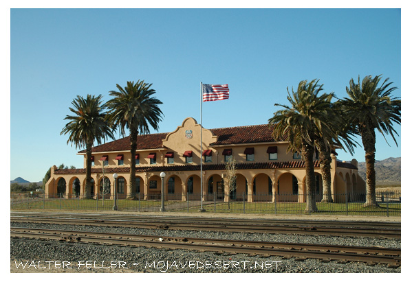
Kelso Depot, also known as the Kelso Depot Visitor Center, is a historic railroad station in the Mojave Desert within the Mojave National Preserve in California. It serves as a significant historical landmark, offering insights into the region’s railroad history and the broader story of the American West.
History and Significance
Construction and Early Years
The Los Angeles and Salt Lake Railroad, later absorbed by the Union Pacific Railroad, constructed Kelso Depot in 1923. The depot was strategically located at Kelso, a small community that sprang up primarily to serve the railroad and the nearby mining operations. The location was chosen because it provided a crucial water stop for steam locomotives and a place to house “helper” engines needed to assist trains over the steep grades of Cima Hill.
Architectural Style
The depot was built in the Spanish Mission Revival style, popular in the southwestern United States during the early 20th century. The building features stucco walls, a red tile roof, and a distinctive colonnade, reflecting the architectural trends of the time. The depot included passenger waiting rooms, a telegraph office, and a restaurant known as the “Beanery,” which served meals to passengers and railroad employees.
Role During the Boom Years
Kelso Depot played a vital role during the peak years of rail traffic. It was a bustling hub for both freight and passenger services. The surrounding area saw significant economic activity due to nearby borax and iron ore mining operations. The depot was an essential stop on the Los Angeles to Salt Lake City route, facilitating the transport of goods and passengers across the desert.
Decline and Abandonment
The need for water stops and helper engines diminished with the advent of diesel locomotives in the mid-20th century. As a result, the importance of Kelso Depot declined. Passenger service was discontinued in 1964, and the depot eventually closed in 1985. The building fell into disrepair and was at risk of demolition.
Preservation and Restoration
Inclusion in Mojave National Preserve
In 1994, the Mojave National Preserve was established, and efforts began to preserve the historical and cultural resources within the area. Recognizing the historical significance of Kelso Depot, the National Park Service (NPS) took on the task of restoring the building.
Restoration Efforts
The restoration of Kelso Depot was a major undertaking by the NPS. The project aimed to return the building to its former glory and adapt it as a visitor center and museum. The restoration preserved many of the depot’s original architectural features while making necessary updates to meet modern safety and accessibility standards.
Kelso Depot Visitor Center
Exhibits and Interpretation
Today, Kelso Depot serves as the primary visitor center for the Mojave National Preserve. It houses a variety of exhibits that explore the natural and cultural history of the Mojave Desert. Displays cover topics such as the geology, flora, and fauna of the region, as well as the history of mining, railroads, and early settlers.
Visitor Amenities
The visitor center offers a range of amenities for park visitors. These include an information desk, interpretive displays, a small bookstore, and public restrooms. The restored “Beanery” provides a glimpse into the dining experiences of early 20th-century railroad travelers.
Educational Programs and Events
Kelso Depot also hosts educational programs and special events throughout the year. Ranger-led tours, interpretive talks, and community events help to engage visitors and deepen their understanding of the Mojave National Preserve’s rich history and natural beauty.
Conclusion
Kelso Depot is a testament to the railroad’s transformative impact on the American West. Its preservation and restoration provide a valuable link to the past, allowing visitors to step back and appreciate the challenges and triumphs of those who lived and worked in the Mojave Desert. Through its exhibits, programs, and architectural beauty, Kelso Depot continues to educate and inspire new generations about the unique history of this remarkable region.
The Mojave National Preserve, encompassing over 1.6 million acres, offers diverse landscapes, wildlife, and recreational activities. Located in southeastern California, the preserve is a haven for outdoor enthusiasts and nature lovers. Here’s an expanded look at what makes the Mojave National Preserve a popular destination:
Key Features and Attractions
Kelso Dunes:
Dune Field: Covering over 45 square miles, the Kelso Dunes are some of the tallest dunes in North America, with the highest peak rising about 650 feet.
Hiking and Exploration: Visitors can hike to the top of the dunes for panoramic views and experience the phenomenon of “singing sands,” a booming sound produced by the movement of the sand.
Sunset Views: The dunes are stunning at sunset when the shifting light creates dramatic shadows and colors.
Hole-in-the-Wall:
Geological Features: This area is named for its unique rock formations created by volcanic activity and erosion. The walls are filled with holes and cavities, giving the area its distinctive appearance.
Rings Loop Trail: A popular 1.5-mile loop trail that features metal rings bolted into the rock to help hikers navigate steep sections of the trail. The trail offers a close-up view of the fascinating rock formations.
Visitor Center: The Hole-in-the-Wall Information Center provides exhibits on the area’s geology, wildlife, and cultural history.
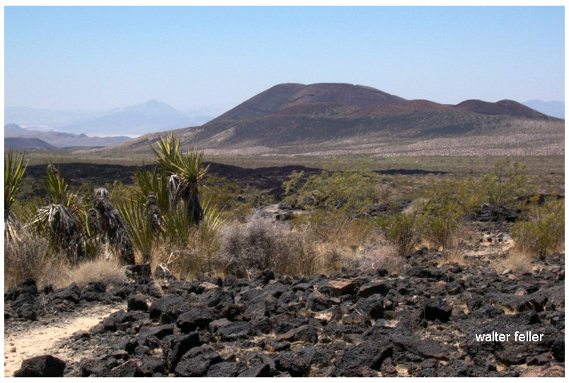
Cinder Cone Lava Beds:
Volcanic Landscape: This area features ancient volcanic cones, lava flows, and craters, offering a rugged and dramatic landscape.
Hiking Trails: Trails wind through the lava beds, providing opportunities to explore the unique terrain and view the surrounding desert.
Mitchell Caverns:
Limestone Caves: Located in the Providence Mountains State Recreation Area, these caverns are filled with stalactites, stalagmites, and other fascinating formations.
Guided Tours: The only way to explore the caverns is through guided tours offered by California State Parks, which provide insights into the caves’ geological history and natural features.
Mojave Road:
Historic Route: The Mojave Road is a historic 140-mile off-road trail that follows a route used by Native Americans, early explorers, and settlers. It provides a challenging and adventurous way to experience the preserve.
Landmarks: Along the route, travelers can see historic sites, old military forts, and natural landmarks. The route requires a high-clearance 4WD vehicle and careful planning.
Wildlife and Plant Life
Desert Flora: The preserve has various desert plants, including Joshua trees, creosote bushes, cacti, and wildflowers. Springtime can bring vibrant blooms, adding color to the landscape.
Wildlife: The preserve’s diverse habitats support a wide range of wildlife, including bighorn sheep, coyotes, desert tortoises, and numerous bird species. The varying elevations and environments within the preserve create unique ecosystems.
Recreational Activities
Hiking:
Diverse Trails: The preserve offers a range of hiking trails, from short nature walks to strenuous backcountry routes. Trails provide opportunities to explore the varied landscapes and observe the native flora and fauna.
Backpacking: For those seeking a more immersive experience, the preserve offers backcountry camping and backpacking opportunities. Permits are required for overnight stays.
Camping:
Developed Campgrounds: The preserve has several developed campgrounds, including Hole-in-the-Wall and Mid Hills, which offer amenities such as picnic tables, fire rings, and restrooms.
Dispersed Camping: For a more primitive experience, visitors can camp in designated areas throughout the preserve. Dispersed camping allows for solitude and a closer connection with nature.
Stargazing:
Dark Skies: The remote location of the preserve provides excellent conditions for stargazing. The lack of light pollution allows for clear views of the night sky, making it a perfect spot for observing stars, planets, and meteor showers.
Bird Watching:
Diverse Bird Species: The varied habitats within the preserve attract a wide range of bird species, making it a popular destination for bird watchers. Seasonal migrations and diverse environments provide opportunities to see both resident and migratory birds.
Off-Roading:
Designated Routes: The preserve has numerous designated off-road vehicle routes, offering adventurous ways to explore the rugged terrain. It’s important to stay on designated routes to protect the environment and adhere to regulations.
Historical and Cultural Sites
Kelso Depot: A restored 1924 Union Pacific train depot now serving as the preserve’s visitor center. The depot features exhibits on the history of the railroad, mining, and desert communities.
Rock Springs Land and Cattle Company: Historical ranch buildings and corrals that provide a glimpse into the ranching history of the area.
Conservation and Preservation
Protected Area: The Mojave National Preserve is managed by the National Park Service, protecting its unique landscapes, wildlife, and cultural resources.
Leave No Trace: Visitors are encouraged to practice Leave No Trace principles, minimizing their impact on the environment and helping to preserve the preserve’s natural beauty and integrity.
Visitor Information
Accessibility: The preserve is accessible via Interstate 15 and Interstate 40, with several entry points and visitor centers providing information and resources.
Seasonal Considerations: The best times to visit are spring and fall when temperatures are moderate. Summer temperatures can be extreme, and winter can bring cold nights and occasional snow at higher elevations.
The Mojave National Preserve offers a diverse and captivating landscape with countless opportunities for exploration and adventure. Whether hiking through rugged canyons, climbing towering dunes, or simply soaking in the vast desert vistas, the preserve provides a memorable and enriching experience for all who visit.
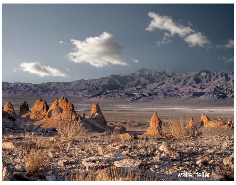
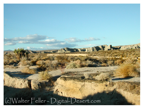
The Trona Pinnacles, located in the California Desert National Conservation Area near the town of Trona, offer a striking landscape of unusual tufa formations rising dramatically from the desert floor. Here’s an expanded look at what makes the Trona Pinnacles a popular destination:
Geological Significance
Formation: The Trona Pinnacles are composed of tufa, a type of limestone that forms in alkaline lake waters. These formations were created 10,000 and 100,000 years ago when the area was submerged under the prehistoric Searles Lake.
Structure: The site features over 500 pinnacles, ranging from small spires to large towers that reach up to 140 feet. These formations vary in shape and size, creating a surreal and otherworldly landscape.
Attractions and Activities
Exploring the Pinnacles:
Self-Guided Tours: Visitors can explore the pinnacles at their own pace, walking among the formations and marveling at their unique shapes and textures. The area is open for hiking and offers numerous trails and pathways.
Interpretive Signs: Informational signs throughout the site provide insights into the geological history of the pinnacles, explaining how they were formed and their significance.
Photography:
Landscape Photography: The Trona Pinnacles are a favorite subject for photographers due to their striking appearance and the dramatic contrasts between the tufa towers and the surrounding desert. The light at sunrise and sunset casts a magical glow on the formations, enhancing their visual appeal.
Astrophotography: The remote location and dark skies make the Trona Pinnacles an excellent spot for stargazing and astrophotography. The formations provide unique foregrounds for night sky photography, including stunning views of the Milky Way.
Off-Roading and Vehicle Access:
Off-Road Trails: The area around the Trona Pinnacles is accessible by dirt roads suitable for high-clearance and four-wheel-drive vehicles. Off-road enthusiasts can enjoy exploring the rugged terrain and discovering hidden viewpoints.
Scenic Drives: For those who prefer a more leisurely visit, scenic drives through the area offer beautiful views of the pinnacles and the surrounding desert landscape.
Camping:
Primitive Camping: The Bureau of Land Management (BLM) allows primitive camping near the Trona Pinnacles. Campers can set up their tents or park their RVs in designated areas, providing a unique opportunity to experience the pinnacles up close, especially during sunrise and sunset.
Stargazing: Camping overnight offers a chance to enjoy the clear desert skies, which are perfect for stargazing and experiencing the tranquility of the desert.
Filming and Events:
Film Location: The Trona Pinnacles have been used as a backdrop for numerous movies, TV shows, and commercials due to their otherworldly appearance. Productions like “Star Trek V: The Final Frontier” and “Planet of the Apes” have featured scenes shot at the pinnacles.
Special Events: Occasionally, the area hosts special events such as photography workshops, stargazing parties, and off-road vehicle rallies, providing unique opportunities for visitors to engage with the site.
Visitor Information
Location and Access: The Trona Pinnacles are about 20 miles east of Ridgecrest, California. The access road to the pinnacles is a graded dirt road off Highway 178, which can be rough in places but is generally passable for most vehicles.
Facilities: The Trona Pinnacles do not have developed facilities. Visitors should come prepared with their water, food, and supplies. Portable toilets are sometimes available, but it’s best to be self-sufficient.
Best Times to Visit
Spring and Fall: These seasons offer mild temperatures, making it the best time for outdoor activities such as hiking and camping. Springtime may also bring wildflower blooms, adding color to the landscape.
Winter: Winter can be a good time to visit if you prefer cooler weather, but be prepared for cold nights. The clear winter skies are excellent for stargazing.
Conservation and Preservation
Protected Area: The Trona Pinnacles are managed by the Bureau of Land Management as part of the California Desert National Conservation Area. Efforts are made to preserve the site’s unique geological features and natural beauty.
Responsible Tourism: Visitors are encouraged to practice Leave No Trace principles, respecting the delicate desert environment and minimizing their impact on the land and formations.
Nearby Attractions
Searles Valley Minerals: The nearby town of Trona is known for its mineral processing facilities. The Searles Valley Minerals plant conducts an annual Gem-O-Rama event, where visitors can collect various minerals and crystals from the Searles Lake deposits.
Death Valley National Park: Located to the east, Death Valley National Park offers additional opportunities for exploring diverse desert landscapes, unique geological features, and historic sites.
Educational and Interpretive Programs
Guided Tours and Talks: Occasionally, the BLM or local organizations may offer guided tours and interpretive talks about the geology and natural history of the Trona Pinnacles, providing deeper insights into the site’s formation and significance.
The Trona Pinnacles offer a unique and memorable experience for visitors interested in geology, photography, outdoor adventure, and the natural beauty of the Mojave Desert. Whether exploring the pinnacles on foot, capturing their striking forms with a camera, or simply soaking in the serene desert atmosphere, the Trona Pinnacles provide an extraordinary destination for all who visit.
Red Rock Canyon State Park, located in the southern Mojave Desert, is renowned for its stunning rock formations, vibrant colors, and rich history. Here’s an in-depth look at what makes Red Rock Canyon State Park a popular destination:
Geological and Natural Features
Spectacular Rock Formations: The park is famous for its dramatic cliffs, buttes, and vividly colored rock layers that span millions of years of geological history. These formations primarily comprise sandstone, volcanic rock, and sedimentary deposits.
Unique Colors: The park’s namesake red cliffs and outcroppings are complemented by layers of white, pink, and brown, creating a visually striking landscape that changes with the angle of the sunlight.
Attractions and Activities
Hiking Trails:
Hagen Canyon Nature Trail: A popular 1-mile loop trail that offers close-up views of the park’s iconic rock formations and opportunities to spot wildlife. It is an easy hike suitable for all ages.
Red Cliffs Trail: A moderate trail that leads hikers through some of the park’s most scenic areas, including red cliffs and narrow canyons. This trail provides excellent photo opportunities.
Nightmare Gulch Loop: A longer, more challenging trail offering a rugged adventure through narrow canyons and dramatic rock formations. It is typically open from July through January due to nesting raptors in the area.
Wildlife Viewing:
Bird Watching: The park’s diverse habitats attract numerous bird species, making it a great spot for enthusiasts.
Camping:
Ricardo Campground: The park’s main campground is located amidst scenic cliffs and rock formations. It offers 50 campsites with picnic tables, fire rings, and restrooms.
Primitive Camping: For a more rustic experience, visitors can opt for primitive camping in designated areas, allowing them to connect more closely with nature.
Photography:
Landscape Photography: The park’s vibrant rock formations and desert vistas provide endless opportunities for landscape photography. Sunrise and sunset are particularly magical times for capturing the beauty of the park.
Night Sky Photography: The park’s remote location and minimal light pollution make it an excellent spot for stargazing and astrophotography. The clear desert skies offer stunning views of the Milky Way and other celestial phenomena.
Off-Roading and Driving:
Scenic Drives: Visitors can enjoy scenic drives through the park, with several dirt roads and trails accessible to high-clearance vehicles. These drives offer a chance to explore more remote areas and enjoy panoramic views.
Off-Road Vehicle Areas: Designated areas within the park allow for off-road vehicle use, providing an adventurous way to explore the rugged terrain.
Cultural and Historical Sites:
Petroglyphs and Historical Artifacts: The park is rich in cultural history, with petroglyphs and artifacts from Native American tribes who once inhabited the area. Interpretive signs provide insights into the historical significance of these sites.
Film and Television Location: Red Rock Canyon has served as a filming location for numerous movies, television shows, and commercials, adding to its cultural appeal.
Visitor Information
Visitor Center: The park’s visitor center offers educational exhibits on the geology, wildlife, and cultural history of the area. It also provides information on hiking trails, camping, and other recreational activities.
Accessibility: The park is easily accessible from major highways, with well-maintained roads leading to the main attractions and facilities.
Best Times to Visit
Spring and Fall: These seasons offer the most comfortable weather for outdoor activities, with mild temperatures and blooming wildflowers in spring.
Winter: The park can be visited year-round, but winter provides cooler temperatures, making it an ideal time for hiking and exploring without the intense heat of summer.
Conservation and Preservation
Protected Area: As a state park, Red Rock Canyon is protected to preserve its natural beauty, wildlife habitats, and cultural resources for future generations.
Leave No Trace Principles: Visitors are encouraged to practice Leave No Trace principles to minimize their impact on the environment and help maintain the park’s pristine condition.
Nearby Attractions
Jawbone Canyon: Located to the north of the park, Jawbone Canyon offers additional opportunities for off-roading, hiking, and exploring unique desert landscapes.
California City: A nearby city that provides additional amenities such as lodging, dining, and shopping for park visitors.
Red Rock Canyon State Park offers a blend of natural beauty, outdoor adventure, and rich history, making it a must-visit destination for anyone exploring the Mojave Desert. Whether you’re hiking, camping, photographing, or simply enjoying the stunning scenery, the park provides an unforgettable experience.
