Regional and Local Knowledge

Regional and local knowledge are not competitors—they are nested and interdependent.

To better understand this relationship, think of it as a hierarchy.

Local knowledge answers questions such as:

  • Who lived here?
  • Where was the spring?
  • Which road did they use?
  • What did people call this place?

In essence, local knowledge is intimate, detailed, and place-specific.

For example, someone in Lucerne Valley might know:

  • which ranch occupied a particular parcel,
  • where an old school stood,
  • How Rabbit Springs changed over time,
  • who built a specific road,
  • or where grinding slicks are found.

That knowledge may never have been published.

Regional knowledge asks a different question:

“How does Lucerne Valley fit into the Mojave Desert?”

It connects the local story to larger patterns.

For example:

Lucerne Valley was not simply a farming community.

Regional knowledge recognizes that it was:

  • part of the traditional homeland of the Serrano and Vanyume,
  • connected to the San Bernardino Mountains through seasonal travel,
  • influenced by nearby mining districts,
  • shaped by the Mojave River watershed,
  • linked to Cajon Pass and later highways,
  • affected by regional groundwater use,
  • and economically tied to Victor Valley and beyond.

Ultimately, the regional perspective explains why Lucerne Valley developed as it did.

Importantly, the relationship between local and regional knowledge works in both directions.

Local knowledge builds regional knowledge.

Imagine a thousand communities, springs, mines, ranches, and canyons.

Each contributes a piece of the puzzle.

Individual site       ↓Local history       ↓Community history       ↓Regional history       ↓Understanding the Mojave Desert

At the same time, regional knowledge also strengthens local knowledge.

Suppose someone finds an old wagon road near Newberry Springs.

A local historian can describe the road.

A regional historian may recognize it as:

  • part of the Mojave Road,
  • a branch of the Old Spanish Trail,
  • a military supply route,
  • a mining freight road,
  • or an early automobile route.

Without the regional context, the road is just an old road.

With the regional context, it becomes part of a much larger story.

This is why regional historians often act as connectors. They recognize that events separated by hundreds of miles are actually related.

For example:

  • A discovery in Holcomb Valley affects freight traffic through Cajon Pass.
  • That increases travel through Victor Valley.
  • This leads to the creation of new stations along the Mojave River.
  • This eventually influences settlement at Barstow.
  • Which changes transportation across the entire desert.

A local historian may document one link.

A regional historian explains the chain.

I think this is where your work naturally fits.

For instance, you’ve written local histories of places like Hesperia, Lucerne Valley, Newberry Springs, Ridgecrest, and Summit Valley. Yet your websites consistently connect those places to broader themes: Indigenous travel networks, the Mojave River, geology, mining booms, transportation corridors, military history, ecology, and settlement.

You’re not replacing local history; rather, you’re integrating it into the larger history of the Mojave Desert.

A useful way to express the relationship is:

Local knowledge tells us what makes a place unique. Regional knowledge explains why that place matters.

Neither is complete alone. Local knowledge gives detail; regional knowledge gives context. Together, they create a fuller understanding of the place and its larger landscape.

necessary gaps between the two

That’s an insightful question. There are necessary gaps between local and regional knowledge. If there weren’t, the two would simply be the same thing at different scales.

Those gaps are actually where much of the work of a regional historian takes place.

Some examples:

1. Scale

A local historian can know nearly everything about one town or valley.

A regional historian cannot know every detail of every community. Instead, they identify the details that matter beyond the local setting.

For example, a Lucerne Valley historian may know every schoolteacher, store owner, and election. A regional historian asks, “How did Lucerne Valley contribute to the development of the Mojave Desert?”

Some local details remain local—and that’s appropriate.

2. Perspective

Local knowledge often looks inward.

Regional knowledge looks outward.

Local:

“This spring supplied our community.”

Regional:

“This spring was one stop in a chain of water sources connecting the Colorado River to the San Gabriel Mountains.”

Both are true, but they answer different questions.

3. Completeness

No regional work can contain every local story.

If it tried, it would become an encyclopedia measured in hundreds of volumes.

Instead, regional knowledge abstracts.

It asks:

  • What is representative?
  • What changed the region?
  • What illustrates larger processes?

Many local details remain intentionally omitted because they do not change the regional picture.

4. Expertise

Local historians often possess knowledge unavailable anywhere else.

Regional historians rely upon them.

Conversely, local historians sometimes don’t see how their own community fits into larger patterns.

The relationship is complementary.

5. Interpretation

This is perhaps the largest gap.

Facts alone don’t create regional knowledge.

Someone must recognize relationships.

For example:

A local historian writes:

  • wagon road
  • spring
  • ranch
  • mining camp

A regional historian recognizes:

  • transportation corridor
  • watershed
  • settlement pattern
  • economic network

The same facts become a different understanding.


For your own work, I think there is another gap.

You often bridge disciplines.

A page about a canyon isn’t only about the canyon.

It’s also about:

  • its geology,
  • Native use,
  • exploration,
  • mining,
  • wildlife,
  • transportation,
  • photography,
  • and modern recreation.

That interdisciplinary connection is difficult to produce because few people work across all of those fields.


I sometimes think of it this way:

Facts   ↓Local knowledge   ↓Regional knowledge   ↓Regional understanding

Most people stop at facts.

Many historians stop at local knowledge.

Fewer people synthesize regional knowledge.

The rarest step is regional understanding—recognizing the forces that have shaped an entire landscape over centuries.

That’s where the enduring value of a regional reference lies. It doesn’t just preserve information; it helps readers see patterns that are invisible when viewed in isolation.
#6 – Trona Pinnacles: A Unique Geological Wonderland

/trona-pinnacles/

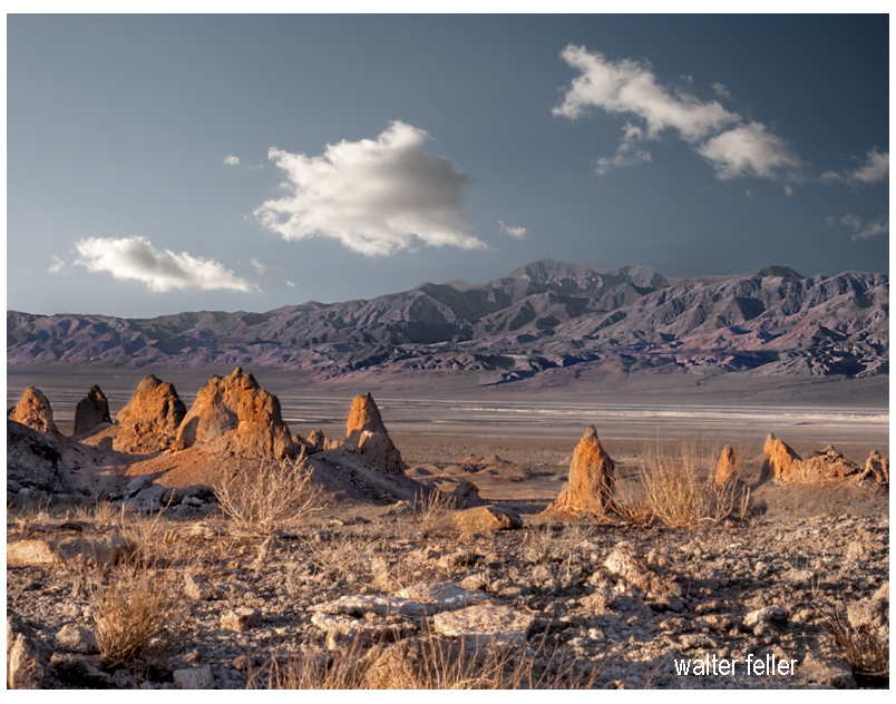
The Trona Pinnacles, located in the California Desert National Conservation Area near the town of Trona, offer a striking landscape of unusual tufa formations rising dramatically from the desert floor. Here’s an expanded look at what makes the Trona Pinnacles a popular destination:

Geological Significance

  • Formation: The Trona Pinnacles are composed of tufa, a type of limestone that forms in alkaline lake waters. These formations were created 10,000 and 100,000 years ago when the area was submerged under the prehistoric Searles Lake.
  • Structure: The site features over 500 pinnacles, ranging from small spires to large towers that reach up to 140 feet. These formations vary in shape and size, creating a surreal and otherworldly landscape.

Attractions and Activities

  1. Exploring the Pinnacles:
    • Self-Guided Tours: Visitors can explore the pinnacles at their own pace, walking among the formations and marveling at their unique shapes and textures. The area is open for hiking and offers numerous trails and pathways.
    • Interpretive Signs: Informational signs throughout the site provide insights into the geological history of the pinnacles, explaining how they were formed and their significance.
  2. Photography:
    • Landscape Photography: The Trona Pinnacles are a favorite subject for photographers due to their striking appearance and the dramatic contrasts between the tufa towers and the surrounding desert. The light at sunrise and sunset casts a magical glow on the formations, enhancing their visual appeal.
    • Astrophotography: The remote location and dark skies make the Trona Pinnacles an excellent spot for stargazing and astrophotography. The formations provide unique foregrounds for night sky photography, including stunning views of the Milky Way.
  3. Off-Roading and Vehicle Access:
    • Off-Road Trails: The area around the Trona Pinnacles is accessible by dirt roads suitable for high-clearance and four-wheel-drive vehicles. Off-road enthusiasts can enjoy exploring the rugged terrain and discovering hidden viewpoints.
    • Scenic Drives: For those who prefer a more leisurely visit, scenic drives through the area offer beautiful views of the pinnacles and the surrounding desert landscape.
  4. Camping:
    • Primitive Camping: The Bureau of Land Management (BLM) allows primitive camping near the Trona Pinnacles. Campers can set up their tents or park their RVs in designated areas, providing a unique opportunity to experience the pinnacles up close, especially during sunrise and sunset.
    • Stargazing: Camping overnight offers a chance to enjoy the clear desert skies, which are perfect for stargazing and experiencing the tranquility of the desert.
  5. Filming and Events:
    • Film Location: The Trona Pinnacles have been used as a backdrop for numerous movies, TV shows, and commercials due to their otherworldly appearance. Productions like “Star Trek V: The Final Frontier” and “Planet of the Apes” have featured scenes shot at the pinnacles.
    • Special Events: Occasionally, the area hosts special events such as photography workshops, stargazing parties, and off-road vehicle rallies, providing unique opportunities for visitors to engage with the site.

Visitor Information

  • Location and Access: The Trona Pinnacles are about 20 miles east of Ridgecrest, California. The access road to the pinnacles is a graded dirt road off Highway 178, which can be rough in places but is generally passable for most vehicles.
  • Facilities: The Trona Pinnacles do not have developed facilities. Visitors should come prepared with their water, food, and supplies. Portable toilets are sometimes available, but it’s best to be self-sufficient.

Best Times to Visit

  • Spring and Fall: These seasons offer mild temperatures, making it the best time for outdoor activities such as hiking and camping. Springtime may also bring wildflower blooms, adding color to the landscape.
  • Winter: Winter can be a good time to visit if you prefer cooler weather, but be prepared for cold nights. The clear winter skies are excellent for stargazing.

Conservation and Preservation

  • Protected Area: The Trona Pinnacles are managed by the Bureau of Land Management as part of the California Desert National Conservation Area. Efforts are made to preserve the site’s unique geological features and natural beauty.
  • Responsible Tourism: Visitors are encouraged to practice Leave No Trace principles, respecting the delicate desert environment and minimizing their impact on the land and formations.

Nearby Attractions

  • Searles Valley Minerals: The nearby town of Trona is known for its mineral processing facilities. The Searles Valley Minerals plant conducts an annual Gem-O-Rama event, where visitors can collect various minerals and crystals from the Searles Lake deposits.
  • Death Valley National Park: Located to the east, Death Valley National Park offers additional opportunities for exploring diverse desert landscapes, unique geological features, and historic sites.

Educational and Interpretive Programs

  • Guided Tours and Talks: Occasionally, the BLM or local organizations may offer guided tours and interpretive talks about the geology and natural history of the Trona Pinnacles, providing deeper insights into the site’s formation and significance.

The Trona Pinnacles offer a unique and memorable experience for visitors interested in geology, photography, outdoor adventure, and the natural beauty of the Mojave Desert. Whether exploring the pinnacles on foot, capturing their striking forms with a camera, or simply soaking in the serene desert atmosphere, the Trona Pinnacles provide an extraordinary destination for all who visit.

/trona-ca/

Covered Wagon (prairie schooner)

/wagons/

Covered wagons significantly impacted the United States’ westward expansion during the 18th and 19th centuries. These wagons, often called “prairie schooners,” were designed to transport goods and settlers across the North American continent.

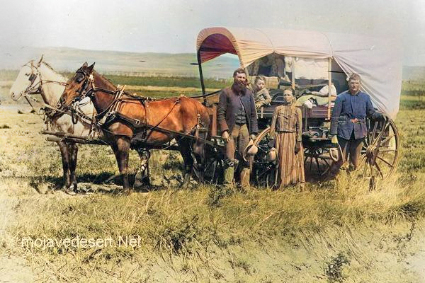
Family & covered wagon (prairie schooner)

Key features and uses of covered wagons included:

  1. Design: Covered wagons typically had a wooden frame with a canvas cover. This cover protected the contents from weather elements like rain and sun. The wagon bed was usually made of wood and was about four feet wide by ten feet long.
  2. Cover: The cover was made of canvas or similar durable cloth, stretched over hooped frames, providing shelter and goods for the occupants.
  3. Wheels: The wheels were often large and designed to handle rough terrain. The front wheels were usually smaller than the rear wheels, allowing easier turning.
  4. Draft Animals: Oxen, mules, or horses were commonly used to pull these wagons. Oxen were preferred for their strength and endurance, especially over long distances.
  5. Role in Expansion: Covered wagons were essential for westward migration in the U.S. They carried settlers’ belongings, including tools, food, and sometimes even passengers. These wagons were a vital part of the movement to settle the American West and were commonly seen on trails like the Oregon Trail, the Santa Fe Trail, and the California Trail.
  6. Living Quarters: The covered wagon was a temporary home for many settlers traveling west. Families would cook, eat, sleep, and spend much of their time in or around the wagon during their journey.
  7. Historical Significance: The image of a covered wagon crossing the plains has become an iconic symbol of American frontier life, representing the pioneer spirit, exploration, and the challenges of frontier life.

The use of covered wagons declined with the advent of railroads, which offered a faster and more efficient means of transporting goods and people across the country. However, their legacy remains an integral part of American history and folklore.

Ghost Towns & Gold Mines

Ghost Towns, Sites, and Gold and Silver Mines in the Mojave Desert

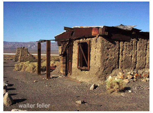
Ballarat, CA.

The Mojave Desert is known for its rich history of mining and the presence of ghost towns and abandoned mines. Here are some notable ghost towns, sites, and gold and silver mines in the Mojave Desert:

  1. Calico Ghost Town: Located near Barstow, California, Calico is one of the most famous ghost towns in the Mojave Desert. It was a thriving silver mining town in the late 1800s but became abandoned when the silver market declined. Today, it’s a well-preserved tourist attraction.
  2. Rhyolite, Nevada: Rhyolite was once a booming gold mining town in the early 1900s. It had over 5,000 people but was quickly abandoned when the mines played out. You can visit the remains of the town and see the famous “Bottle House” made of glass bottles.
  3. Goldfield, Nevada: Goldfield was another prosperous gold mining town in Nevada. It had a peak population of around 20,000 people in the early 1900s. The Goldfield Hotel and several historic buildings still stand today.
  4. Panamint City, California: This remote ghost town in Death Valley National Park was a silver mining town in the late 1800s. It’s accessible via a challenging hike and offers stunning views of the surrounding desert.
  5. Cerro Gordo, California: Cerro Gordo is an old silver mining town still privately owned. It’s located in the Inyo Mountains and has a well-preserved ghost town, including a general store, bunkhouse, and other structures.
  6. Mines in the Mojave Desert: The Mojave Desert is home to numerous gold and silver mines, many of which are abandoned. These mines contributed to the region’s mining history. Some notable mines include the Tonopah-Belmont Mine, the Desert Queen Mine, and the Goldstone Mine.

Remember that exploring abandoned mines can be dangerous due to unstable structures and the presence of toxic gases. It’s essential to exercise caution and, if needed, seek permission or guidance from local authorities or landowners when visiting these sites. Additionally, some ghost towns and mines may be on private property, so be respectful of any access restrictions.