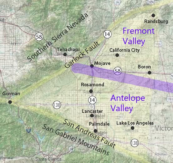
Antelope Valley occupies the western end of the Mojave Desert, mainly in northern Los Angeles County and southeastern Kern County. Its roughly triangular shape follows the surrounding mountains and the low divides separating it from neighboring desert basins.
Direction Geographic boundary
West The narrowing end of the valley toward Gorman and the junction of the surrounding mountain ranges
Northwest Tehachapi Mountains
North Rosamond Hills and Bissell Hills, beyond which lies Fremont Valley
South San Gabriel Mountains and their western extensions
East Low hills and drainage divides separating Antelope Valley from the Fremont, Harper, and upper Mojave River basins
USGS describes these physical boundaries as a westward-pointing wedge between the San Andreas and Garlock fault zones. pubs.usgs.gov
The valley floor generally stands about 2,300 to 3,500 feet above sea level. It is an internally drained basin: runoff flows toward low areas and dry lakebeds instead of reaching the ocean. pubs.usgs.gov
For defining a map area, distinguish Antelope Valley proper from the broader region commonly called Antelope Valley. The physical basin, groundwater basin, and community service areas use different boundaries. In particular, Antelope and Fremont valleys are separate basins, although their adjoining desert plains can appear continuous.
–
Fremont Valley lies in eastern Kern County in the western Mojave Desert, north and northeast of Antelope Valley. Its broad desert plain slopes toward Koehn Dry Lake.
Direction Geographic boundary
West and northwest Southern Sierra Nevada foothills and the El Paso Mountains
Southwest Tehachapi Mountains
North El Paso Mountains, along the Garlock fault zone
East and southeast Rand Mountains and adjoining low hills
South Low hills and drainage divides separating Fremont Valley from Antelope Valley
These boundaries describe the general landform. The southern boundary is less conspicuous than the surrounding mountain fronts because the two valleys meet across relatively open desert terrain. pubs.usgs.gov
Fremont Valley has internal drainage. Runoff flows toward Koehn Dry Lake, its low point at approximately 1,900 feet above sea level, rather than reaching the ocean. Alluvial fans descend from the surrounding mountains toward the valley floor. water.ca.gov
For mapping, distinguish the surface drainage basin from the groundwater basin. Their boundaries do not match everywhere. The groundwater boundary with Antelope Valley follows a southeastward-trending divide beginning near the mouth of Oak Creek. pubs.usgs.gov