Mojave History

The Mojave Desert can look empty from the highway. It isn’t, and it never was.

People lived here long before there were highways or railroads. They knew where to find water, when plants were ready to gather, and how to travel from one spring to the next. Trails connected the Colorado River, the Mojave River, the mountains, and the valleys beyond them.

Later travelers followed many of those same routes. Traders, trappers, emigrants, soldiers, and road builders each left something behind. Connected, these stories make more sense when we begin with the trails and the water.

The Mojave River Trail

The Mojave River offered a way through the western desert. Much of its water ran beneath the sand, but in certain places it reached the surface. Native travelers knew those places and used the river corridor as part of a wider trail network.

Spanish Forays into the Heart of the Mojave

Native people had traveled across the Mojave for generations before Spanish visitors left written accounts of the route.

In 1776, Father Francisco Garces traveled west from the Mojave villages on the Colorado River. Three Mojave guides accompanied him toward Mission San Gabriel. They passed through the eastern Mojave and continued along the Mojave River. Garces encountered Native travelers along the way, including people trading with communities farther west.

He established no mission or settlement in the desert. His account gives us an early written glimpse of a route that was already in use.

Trappers Follow the River

In 1826, Jedediah Smith crossed the Colorado River, crossed through the Mojave, and followed the Mojave River toward Cajon Pass. Native guides helped his party find the way. Smith returned the following year, when a confrontation at the Colorado River left most of his party dead. He and the survivors continued west across the desert.

Other trappers used parts of the route. Their journeys brought the Mojave River corridor into written accounts of American travel, though Native people had known and used it long before the trappers arrived.

The Old Spanish Trail Takes Shape

In 1829, Antonio Armijo led a trading caravan from New Mexico to California. His route crossed the desert via the Amargosa and Mojave rivers and entered the settled valleys through Cajon Pass. In later years, traders used several related routes that became known collectively as the Old Spanish Trail.

Most of this traffic moved by pack mule. New Mexican traders brought blankets and other goods west and returned with California horses and mules. The trail had branches and alternatives; it was never one fixed track across the desert.

The Old Spanish Trail and the older Mojave Indian Trail were distinct routes, though both used the Mojave River corridor. Keeping them separate helps explain how different travelers reached the river.

Horse Thieves, Walkara, and Miguel Blanco

Trade was only part of the traffic. During the 1830s and 1840s, raiders took horses and mules from California missions and ranchos and drove them east across the desert.

Walkara, a Ute leader, was one of the best-known raiders. His parties crossed into Southern California and used desert trails to move animals away from the ranches. The raids alarmed people living near Cajon Pass.

In 1843, Governor Manuel Micheltorena granted Rancho Muscupiabe at the mouth of the pass to Michael White, also known as Miguel Blanco. One purpose of the grant was to place someone where he could watch for stock thieves coming through from the Mojave. Blanco stood near a busy crossing: traders came in, raiders went out, and the settled valley began just beyond him.

Fremont and Carson on the Old Spanish Trail

In 1844, John C. Fremont traveled east from California with Kit Carson as one of his guides. The party came across the desert from the west, reached the Mojave River, and followed it downstream before turning northeast on the Old Spanish Trail.

Along the way, men who had escaped an attack near Resting Springs came into Fremont’s camp. Carson and fellow guide Alexis Godey pursued the people accused of taking their horses. They returned with some of the animals after a violent encounter. Fremont recorded the episode from his party’s perspective; the people they pursued left no comparable account.

Fremont brought the route to a wider American audience. He and Carson did not open it. By 1844, Native travelers, traders, and horse drovers had long been using its connected paths.

Ben Wilson Pursues the Horse Raiders

In 1845, Governor Pio Pico sent Benjamin D. Wilson, known as Don Benito, after men accused of raiding Southern California ranches.

Wilson divided his force. He took 22 men through the San Bernardino Mountains to Bear Valley, while the rest traveled through Cajon Pass. The parties joined on the Mojave River and rode downstream for several days. There, Wilson encountered four Native men, including a man he identified as Joaquin. The meeting turned violent. An arrow wounded Wilson, and all four men were killed.

Another part of Wilson’s force attacked a group holding a rocky position farther downriver but withdrew after several men were wounded. Wilson told the story years later in his memoir. It gives us an account of the route and the fighting, but the accusations and motives come chiefly from Wilson’s side.

Mormon Battalion Veterans Cross the Desert

The Mormon Battalion was discharged from U.S. Army service in Los Angeles in July 1847. Most of the men who headed for Salt Lake went north through California before turning east. Others later took the southern route across the Mojave.

About 80 men reenlisted for a short period of service in California. After their discharge in March 1848, a party led by Henry G. Boyle traveled east over the Old Spanish Trail with a wagon and a herd of mules, then turned north toward Salt Lake. Pack trains had used the route before, but a wagon required a more passable track.

Their crossing represented a step in the shift from pack trail to wagon road. It also connected Southern California with the new settlement in the Salt Lake Valley.

Hunt’s 49ers Wagon Train

In 1849, Jefferson Hunt led a wagon train toward California via the Old Spanish Trail. Taking wagons over a route long used by pack animals was difficult, but Hunt knew where it led.

Some emigrants heard of a shortcut and left his party to try it. Hunt doubted the route. Many of those who departed soon turned back and rejoined him. Others continued into the country that would later be called Death Valley.

Hunt’s party stayed with the known route toward Cajon Pass and Los Angeles. The episode showed the value of knowing a trail’s water and crossings, even when the trip was hard.

Beale’s Wagon Road and the Mojave Road

By the late 1850s, the United States wanted a wagon route across the Southwest. Edward F. Beale was assigned to survey and improve a road along the 35th parallel to the Mojave villages on the Colorado River. He reached the river in 1857 and continued across the California desert on an existing route.

Work under Beale’s direction later improved the old Mojave trail for wagons. The road crossed the eastern Mojave via its springs and became widely known as the Mojave Road or Government Road. Accounts also used Beale’s name for the wider wagon route.

The names changed, and road crews improved parts of the route, but travelers still depended on a chain of water sources that Native people had known long before the government sent out its crews.

Lane’s Crossing

Aaron G. Lane settled at an established crossing of the Mojave River below the Lower Narrows, near present-day Victorville. He was there by December 1858 and developed a stopping place for travelers. The crossing took his name, but travelers had used it before he arrived.

Bitter Spring and Camp Cady

In March, Thomas S. Williams and Jehu Jackman were killed near Bitter Spring on the Salt Lake Road. People blamed Paiutes, though who killed the men remains uncertain. The Army sent Major James H. Carleton into the desert. His troops established Camp Cady on the Mojave River, then searched the surrounding country and killed Native people they held responsible. There is no clear evidence that those killed had taken part in the Bitter Spring attack.

Draft sectionSources to cite
Mojave River Trail; Spanish foraysThe National Park Service’s The Mojave Road & the Old Spanish Trail documents the older Native trail network, its water sources, Garcés’s three Mojave guides, and the trade he observed in 1776. nps.gov
Trappers follow the riverThe same NPS history covers Smith’s guided crossing in 1826, the deadly encounter on his return in 1827, and later trappers on the route. nps.gov
Old Spanish TrailNPS sources document Armijo’s 1829 caravan, the Amargosa–Mojave River route, later alternatives, and the pack mule trade: Armijo biography and trail history. nps.gov
Walkara and Miguel BlancoNPS has separate accounts of Ute horse raiding and Michael White’s 1843 Muscupiabe grant. nps.gov
Frémont and CarsonCite Frémont’s own 1845 expedition report for his account of the journey and the encounter involving Carson and Godey. Attribute the account of the violence to Frémont, as your draft does. Biodiversity Heritage Library
Ben WilsonWilson’s Observations on Early Days in California, especially PDF pages 7–9, is the direct source for the 22 men, the meeting with Joaquin, Wilson’s wound, and the four deaths. benjamindaviswilson.com
Mormon Battalion veteransThe Church History Library’s Mormon Battalion timeline, Boyle company record, and linked Boyle reminiscences support the discharge, reenlistment, and 1848 wagon journey. history.churchofjesuschrist.org
Hunt’s 49ersDeath Valley National Park’s The Lost ’49ers covers Hunt, the proposed shortcut, the wagons that returned, and those that continued toward Death Valley. home.nps.gov
Beale’s roadThe NPS Mojave Road history distinguishes Beale’s assignment to the Colorado River from the later improvements to the California trail. nps.gov
Lane’s CrossingThe Lane’s Crossing historical marker gives the December 1858 evidence and the location below the Lower Narrows. This is a thinner source than those above, so I would retain “by December 1858” rather than imply a known settlement date. hmdb.org
Bitter Spring and Camp CadyThe NPS Mojave Road history documents Carleton’s orders, the 1860 campaign, and Camp Cady; its notes identify Dennis Casebier’s Carleton’s Pah-Ute Campaign and a contemporary Deseret News report as further references.

Indian Trails in the Mojave Desert

An ancient network of Indigenous trails crosses the Mojave Desert. Long before explorers, traders, soldiers, and settlers entered the region, Native peoples used these routes to travel between settlements, springs, hunting grounds, gathering areas, ceremonial places, and neighboring communities.

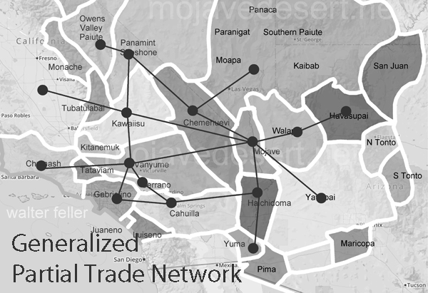
These were not random paths across an empty landscape. They reflected generations of accumulated knowledge about water, terrain, weather, plants, animals, and seasonal conditions. Although historical records often call them “Indian trails,” these routes crossed the homelands of several distinct peoples, including the Mojave, Chemehuevi, and other Southern Paiute groups, Vanyume or Desert Serrano, Kawaiisu, Cahuilla, and others.

A named trail was not necessarily one narrow, unchanging path. Travelers might follow parallel branches or seasonal alternatives depending on available water, weather, vegetation, political relationships, and the purpose of a journey.

Trade and Communication

The trails formed an extensive network connecting the Colorado River, Mojave River, Great Basin, mountain regions, and southern California coast. Some routes covered great distances, while others connected nearby springs, camps, and resource areas.

Travelers carried pottery, shells, minerals, food, plant products, animal materials, and manufactured objects between communities. Trade moved more than material goods: stories, news, technologies, and cultural practices traveled with the people who followed the trails.

The routes also supported social and diplomatic relationships. They allowed families to visit relatives, participate in ceremonies, arrange marriages, exchange information, and maintain connections with neighboring peoples.

Archaeological evidence confirms that goods traveled considerable distances. Marine-shell beads manufactured along the Pacific Coast reached communities throughout the Mojave Desert and farther east. Shell beads recovered from desert archaeological sites provide physical evidence of connections between coastal California, the Mojave River corridor, and the interior Southwest.

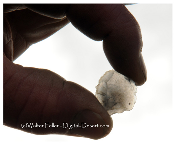
Obsidian chip found in campfire ashes in San Bernardino mountains

Obsidian provides another record of long-distance movement. Each volcanic source has a distinctive chemical composition, allowing researchers to determine where the stone used to make a tool originated. Obsidian from the Coso volcanic field, northwest of the Mojave Desert, has been identified in artifacts found from San Francisco Bay to San Diego, Death Valley, and the eastern Mojave Desert.

The Mojave River Corridor

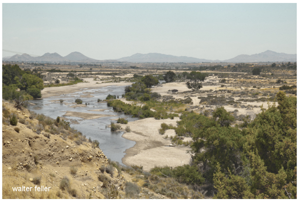
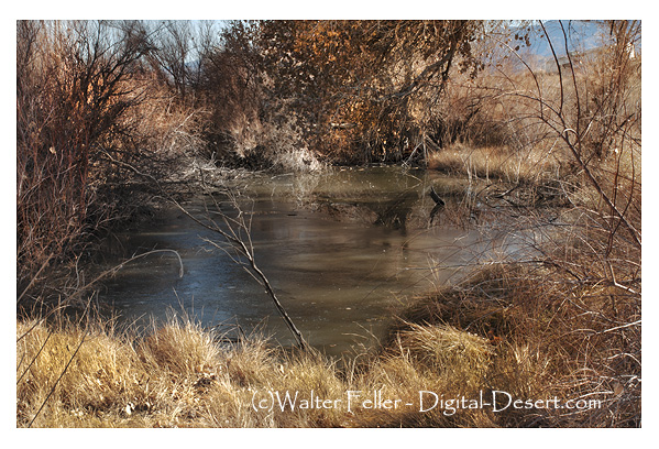
The Mojave River was both a travel corridor and an inhabited landscape. Most of the river flows beneath the surface, but bedrock formations and other geological conditions bring water near or above ground at certain locations. These places were generally more dependable than the surrounding river channel and supported settlements, camps, and vegetation.

Mojave River at Hesperia

Vanyume communities occupied the Mojave River corridor, particularly around its more dependable water sources. The Vanyume are generally identified as the desert division of the Serrano. Their position along the river placed them between the Mojave villages of the Colorado River and the peoples of the San Bernardino Mountains and coastal valleys.

Chemehuevi communities occupied portions of the desert east of the Sinks of the Mojave, while Desert Kawaiisu territory extended north of the river. The boundaries between territories were not empty divisions; they were areas connected by travel, exchange, kinship, and sometimes conflict.

Travelers entering the Mojave River corridor therefore did not encounter an unoccupied natural highway. They passed through a populated country with established territories, settlements, social relationships, and trading connections. Archaeological and historical evidence indicates that the corridor played an important role in moving Pacific Coast shell beads and other goods.

One major route extended west from the Mojave villages along the Colorado River. Travelers crossed the eastern desert by moving between known springs, including Piute Spring, Rock Springs, Marl Spring, and Soda Springs. From the vicinity of Soda Lake, the route followed the Mojave River upstream toward the San Bernardino Mountains.

Traveling Across the Desert

During Isabel Kelly’s 1932–1933 fieldwork, a Southern Paiute consultant identified as Mataviam described how a traveling party prepared for a journey. Catherine S. Fowler later included the account in her reconstruction of Southern Paiute and Chemehuevi trails. It records one knowledgeable person’s description and should not be treated as a universal account of travel by every community.

According to Mataviam, travelers carried their possessions on their backs and used whatever footwear was available. Children wore shoes, and adults took turns carrying children who were too young to walk.

Members of the party also took turns carrying the water jar in an ais, or burden basket, or in a net. They packed blankets and other necessities. Women carried cooking equipment, including manos, but not the heavier metates. A mano was the small handheld stone used to grind seeds and other foods against the larger metate.

Men carried weapons and walked at the front of the party. Dogs accompanied the travelers. Children who were old enough to walk were given small objects, such as skin bags, to carry, but did not ordinarily carry burden baskets or nets.

Water and the Trail System

Water determined when people could travel, which trails they could use, and how long they could remain in a particular place. Springs, seeps, river channels, natural rock tanks, and sandstone potholes supplied water along the routes, but not every source was dependable year-round.

Journeys across especially dry sections had to be timed according to recent rain and the expected condition of the water sources. A rock tank or pothole that held water one season might be empty the next. Successful travel therefore depended upon inherited geographical knowledge and current information exchanged among families and communities.

Trails usually followed the most practical course rather than the shortest straight line. They connected dependable water sources and used passes, canyons, ridges, and other natural features. Some ran along the bases of mountain ranges, where springs and plant resources were more likely. Others crossed open valleys to reach isolated water sources or distant settlements.

The routes also connected different ecological zones. Desert valleys supplied mesquite beans, seeds, roots, and other plant foods. Foothills and mountains offered agave, pinyon nuts, game, timber, and seasonal vegetation. Trails allowed people to move between these areas as resources became available.

Trails, Songs, and Cultural Landscapes

Some Indigenous trail traditions encompass both physical routes and sequences of places preserved through songs and oral knowledge. The Salt Songs of the Nuwuvi, or Southern Paiute people, recount a journey through a succession of named mountains, springs, valleys, and settlements across portions of Nevada, California, Arizona, and Utah.

The songs connect individual places into a ceremonial geography. The Salt Song Trail is therefore not simply one continuously visible footpath. It includes physical routes, remembered places, spiritual relationships, and knowledge passed between generations.

Portions of this cultural landscape cross the Mojave Desert near Fenner and Ward Valley. Including the Salt Song Trail within Mojave Trails National Monument recognizes that ancient travel routes may remain part of living Indigenous traditions.

Other trails may also be associated with origin traditions, ceremonies, ancestral events, or places where people sought spiritual power. Some of this knowledge is private or shared only under appropriate circumstances. Archaeological evidence alone cannot fully explain a trail’s meaning without the participation of the Indigenous communities connected to it.

Recognizing Ancient Trails

An old trail may survive as a shallow tread, a cleared line through desert pavement, a worn passage between rocks, or a series of disconnected segments leading toward a spring or mountain pass.

Archaeologists also examine features associated with the route. These may include:

  • Stone cairns or alignments
  • Pottery fragments
  • Stone flakes and tools
  • Temporary camps and shelters
  • Milling and grinding features
  • Rock art
  • Ceremonial locations
  • Connections between springs, passes, and habitation sites.

No single feature necessarily proves a trail’s age or identity. Mining, livestock, military exercises, utility construction, and modern recreation have created many additional paths across the desert.

Nor can every physical trail segment be assigned confidently to a route remembered in oral tradition. Archaeological sites are usually recorded as particular locations, while an ethnographic trail may extend across an immense cultural landscape. Connecting the two requires archaeological study, historical evidence, and consultation with Indigenous communities.

Indigenous Trails and Later Routes

European and American travelers depended heavily upon the Indigenous trail system. Native guides and established paths helped missionaries, trappers, traders, military expeditions, and settlers cross unfamiliar country.

The historic Mojave Road followed and enlarged an older Indigenous trail corridor connecting the Mojave villages along the Colorado River with springs across the eastern desert and the Mojave River to the west. The Indigenous predecessor is generally called the Mojave Trail or Mojave Indian Trail.

In 1776, Franciscan missionary Francisco Garces traveled west from the Mojave villages with Mojave guides who knew the established trading route to the coastal missions. Along the way, he encountered Mojave travelers returning from the coast after trading for shells. Garces left the earliest surviving written account of travel over much of this route, although Indigenous people had used it for generations.

In 1826, American trapper Jedediah Smith followed the Mojave Trail corridor across the desert and continued along the Mojave River into California. His party became the first group of American citizens known to have reached California overland.

Smith entered the region again in 1827. After an attack at the Colorado River crossing killed ten members of his party, Smith and eight survivors found their way back to the Mojave Trail and continued west.

The route known collectively as the Old Spanish Trail grew out of several expeditions and route variants. Antonio Armijo’s 1829–1830 caravan established the first documented commercial connection between New Mexico and California, using existing Indigenous travel corridors where practicable. Later traders developed other branches, so the Old Spanish Trail became a network rather than one unchanging path.

Pack animals, wagon traffic, military construction, roads, and railroads later widened, displaced, or erased portions of the earlier foot trails. In other places, newer transportation routes paralleled Indigenous paths because the older trails already followed the most practical courses between water sources and mountain passes.

Cultural Legacy and Preservation

Many Indigenous trails remain visible as narrow paths, worn passages, rock alignments, or routes connecting known water sources. Others have been altered or erased by mining, roads, construction, off-road vehicles, military activity, livestock, and natural erosion.

Even where a trail is no longer visible, its associated springs, camps, gathering places, and cultural sites may survive. Archaeologists study these features to reconstruct movement and land-use patterns, but Indigenous knowledge remains essential to understanding their cultural meaning.

Systematic protection of the desert’s archaeological resources developed slowly. Russell L. Kaldenberg, a longtime Bureau of Land Management archaeologist, explained that the growth of off-road recreation during the 1960s and 1970s exposed previously undocumented sites to increasing damage. At the same time, new roads, power lines, utility corridors, and other developments disturbed archaeological remains before many had been inventoried.

The BLM responded by expanding archaeological surveys, assigning archaeologists to its desert offices, preparing cultural-resource management plans, and monitoring important sites. Depending upon their circumstances, sites were fenced, stabilized, interpreted for visitors, or deliberately kept out of public view. Kaldenberg emphasized that effective protection requires long-term inventory, monitoring, public education, and cooperation among agencies, tribal communities, researchers, nonprofit organizations, and volunteers.

Trail locations can also be sensitive. Publicizing the precise location of an unprotected trail or cultural site may expose it to vandalism, unauthorized collecting, or vehicle damage. Preservation therefore requires cooperation among tribal communities, land managers, archaeologists, historians, and responsible visitors.

A Living Cultural Landscape

The Indian trails of the Mojave Desert are not merely remnants of a vanished past. They remain part of the histories and cultural landscapes of contemporary Indigenous nations whose ancestors created and maintained them.

Together, these routes record trade, family travel, resource gathering, ceremony, communication, and adaptation to the desert environment. They demonstrate how detailed knowledge of water, seasons, and terrain made travel possible across country that outsiders often misunderstood as empty or impassable.

Understanding these trails changes how people see the Mojave Desert. Rather than an unoccupied wilderness crossed only by later explorers and settlers, it emerges as an interconnected cultural landscape shaped by human movement over many generations.

Related pages

Sources

Catherine S. Fowler, “Southern Paiute-Chemehuevi Trails Across the Mojave Desert: Isabel Kelly’s Data, 1932–33.” Paper presented at the American Anthropological Association Annual Meeting, 2004.

Catherine S. Fowler, “Reconstructing Southern Paiute-Chemehuevi Trails in the Mojave Desert of Southern Nevada and California: Ethnographic Perspectives from the 1930s.” In James E. Snead, Clark L. Erickson, and J. Andrew Darling, editors, Landscapes of Movement: Trails, Paths, and Roads in Anthropological Perspective. University of Pennsylvania Museum of Archaeology and Anthropology, 2009, pages 84–105.

David D. Earle, “The Mojave River and the Central Mojave Desert: Native Settlement, Travel, and Exchange in the Eighteenth and Nineteenth Centuries.” Journal of California and Great Basin Anthropology 25(1), 2005, pages 1–38.

James T. Davis, Trade Routes and Economic Exchange Among the Indians of California. University of California Archaeological Survey, Report No. 54, 1961.

Ruth Arlene Musser-Lopez and Steve Miller, “Archaeological Trails and Ethnographic Trails: Can They Meet?” Proceedings of the Society for California Archaeology, Volume 24, 2010.

Elizabeth von Till Warren, Ralph J. Roske, and Elizabeth Nelson Patrick, Cultural Resources of the California Desert, 1776–1880: Historic Trails and Wagon Roads. Russell L. Kaldenberg, series editor. Bureau of Land Management, California Desert District, 1981.

Russell L. Kaldenberg, “The History of the Bureau of Land Management Cultural Resource Program in California: A Perspective from Near the Beginning.” Proceedings of the Society for California Archaeology 10, 1997, pages 177–183.

National Park Service, “The Mojave Road and the Old Spanish Trail.”

Presidential Proclamation 9395, “Establishment of the Mojave Trails National Monument,” 2016.

Arizona & California Railroad Bridge

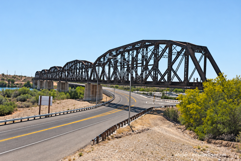
The Arizona and California Railway built its main line between 1903 and 1910, creating a shorter connection between Phoenix and the Santa Fe Railway’s transcontinental route across the Mojave Desert. The railroad also provided transportation for mining districts, agricultural settlements, and communities along the lower Colorado River.[1][2]

Construction proceeded westward from A&C Junction—later renamed Matthie—near Wickenburg, Arizona. The tracks passed through Aguila, Salome, and Bouse before reaching Parker in June 1907. The Colorado River remained a major obstacle between the advancing railroad and its intended connection with the Santa Fe in California.[1][2]

In March 1908, Congress granted the Arizona and California Railway a right-of-way through the Colorado River Indian Reservation. The legislation also provided land for station grounds, terminals, and related railroad facilities.[3] The company completed its bridge across the Colorado River near Parker in June 1908.[1][2]

Steel through-truss spans carried the track across the river’s main channel, while wooden trestles supported the approaches across the adjoining floodplain. The structure created the first fixed railroad crossing of the Colorado River in the Parker area and allowed construction to continue westward through Vidal, Rice, and other remote Mojave Desert stations.[1][4]

The tracks reached Cadiz on June 10, 1910, connecting with the Santa Fe main line between Barstow and Needles. Regular service began July 1. The completed route shortened rail travel between Phoenix and Southern California while providing a practical means of transporting passengers, livestock, agricultural products, mining supplies, and ore.[1][2]

The railroad also played an important role in Parker’s establishment. Congress authorized the Parker townsite on April 30, 1908, and the secretary of the interior formally established it on June 10. Capt. William Strover surveyed the original townsite between January 7 and March 31, 1909. Parker subsequently developed around its railway station, terminal facilities, and strategic river crossing.[3]

In 1911, the Arizona and California Railway was consolidated into the California, Arizona and Santa Fe Railway, another Santa Fe subsidiary. Passenger service ended in October 1955, but freight operations continued. The modern Arizona and California Railroad assumed operation of the route in 1991 and established its headquarters in Parker.[1][2][5]

A fire damaged the bridge’s wooden approach, ties, and track structure on September 14, 2019, temporarily closing the line.[6] Repair crews returned the crossing to service approximately eight days later. More than a century after its completion, the Parker railroad bridge remains an active transportation link between Arizona and California.

References

  1. David F. Myrick, Santa Fe to Phoenix, Railroads of Arizona, vol. 5 (Berkeley and Wilton, California: Signature Press, 2001). Bibliographic record.
  2. Gregg Wilkerson and Larry M. Vredenburgh, “Railroads and Mining in the Mojave Desert and Southwestern Great Basin, California and Nevada,” 2024 Desert Symposium Field Guide and Proceedings (2024), 47–70.
  3. “Town Snapshot: Parker—The Western Gateway of Arizona,” League of Arizona Cities and Towns.
  4. “Arizona and California Railroad Bridge,” Arizona Memory Project.
  5. Arizona and California Railroad, Genesee & Wyoming.
  6. “Bridge Fire Temporarily Severs Arizona & California Railroad,” Railfan & Railroad, September 16, 2019.

Eastbridge and the First Railroad Bridge at Needles

Eastbridge was an Atlantic and Pacific Railroad station on the Arizona bank of the Colorado River, approximately three miles southeast of Needles, California. It marked the eastern end of the first railroad bridge across the Colorado River in the Needles area.

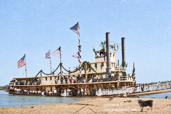
Historic photograph and description -Huntington Library -mssMarston papers V103/0125 (colorized- wfeller)

The Atlantic and Pacific reached the river from northern Arizona in 1883, while the Southern Pacific completed its line eastward from Mojave to Needles. Connecting the two systems required a bridge across the broad floodplain of the Colorado. The chosen crossing was more than 1,600 feet wide and offered no firm rock foundation on either bank.

Construction began during the river’s spring rise. Crews repeatedly attempted to drive wooden piles into the shifting riverbed, only to have the current dislodge their work. In the deeper channel, a pile driver mounted on Barge No. 3 was maneuvered and held in place by the steamboat Mohave II. The crossing was completed in August 1883, establishing a continuous railroad route across the Colorado.

Its location soon proved unsuitable. Floodwater repeatedly damaged or undermined the wooden pile structure, requiring major reconstruction after the floods of 1884, 1886, and 1888. Rather than continue repairing the vulnerable crossing, the railroad constructed a new alignment southward along the California bank through Beal to Mellen.

At Mellen, opposite present-day Topock, engineers could anchor a bridge to rock. The resulting steel cantilever structure, commonly called the Red Rock Bridge, was completed in 1890. Once trains began using the new crossing, the former alignment through Powell and Eastbridge was abandoned, and the old wooden bridge was removed. Eastbridge subsequently disappeared from railroad timetables and maps.

https://mojavedesert.net/railroads/atlantic-and-pacific/

https://digital-desert.com/colorado-river/

https://mojavedesert.net/steamboats/colorado-steamboats.html

https://mojavedesert.net/railroads/southern-pacific-railroad/

https://digital-desert.com/mojave-ca/

https://digital-desert.com/needles-ca/

References

Life Cycle of Rocks

How Sand Forms: A Step-by-Step FAQ

What is sand?

Sand is loose grains of rock or mineral. Most light-colored sand is quartz, a hard mineral that lasts a long time. Desert sand can also contain fragments of granite, volcanic rock, and other local materials.

How does rock become sand?

  1. Rock is exposed at the ground surface.
  2. Heat, cold, rain, frost, plant roots, and chemical changes crack the rock apart.
  3. Gravity, runoff, streams, and floods carry the broken pieces downhill.
  4. Moving water and wind grind the fragments against one another, making them smaller and often smoother.
  5. As the material is sorted, the grains that are roughly sand-sized remain as sand. Finer material becomes silt or clay; larger pieces remain gravel, cobbles, or boulders.

How does sand reach the desert?

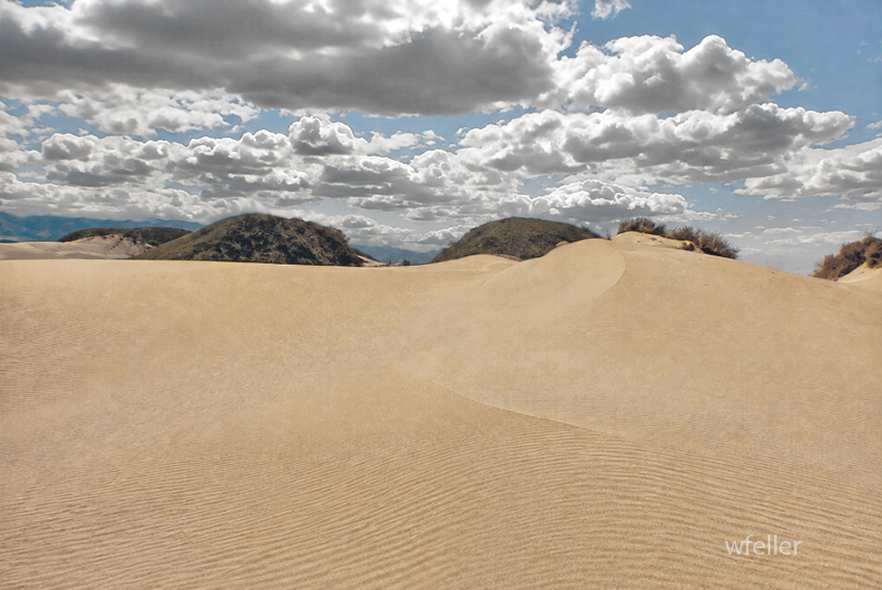
In the Mojave, mountains are the main source. Rainstorms wash broken rock into canyons and desert washes. Floodwater spreads the material across fans and valleys. When the water dries, wind can pick up the finer grains and move them into dunes or broad sheets of sand.

How long does it take?

The work never really stops. A storm can break rock loose and move sand in a single day, but building a large sand deposit usually takes thousands to tens of thousands of years. The source rocks themselves may be millions of years old.

What does “recent geologic time” mean?

For desert deposits, it often means the Quaternary Period, the last 2.58 million years. Many dunes, wash deposits, and dry-lake sediments are much younger, often only thousands or tens of thousands of years old.

Can sand become rock again?

Yes. If sand is buried, pressure compacts it. Groundwater may carry dissolved minerals into the spaces between the grains. Silica, calcite, or iron minerals can cement the grains together, forming sandstone.

What are petrified dunes?

“Petrified dunes” is a common name for ancient sand dunes that have turned into sandstone. Their sloping internal layers, called cross-bedding, preserve the shape of the old wind-blown dunes.

Does this process make more sand?

Yes. It is a long recycling process:

Rock breaks down into sand.
Sand can harden into sandstone.
Weathering can break the sandstone into sand again.

Wind, water, weather, and time keep the material moving through that cycle.

Then . . .

Rock breaks down into sand.
Sand can harden into sandstone.
Weathering can break the sandstone into sand again. . . .