Serrano Indians

https://mojavedesert.net/serrano-indians/

Communal grinding stone in San Bernardino Mountains

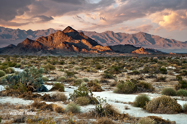
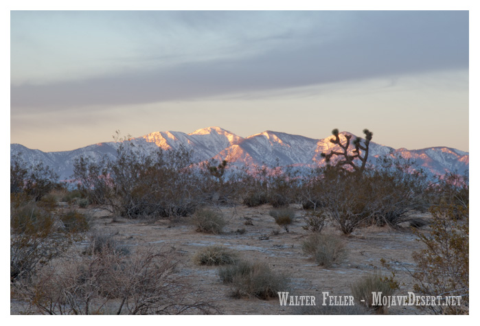
The Serrano are a Native American people who historically resided in the San Bernardino Mountains and the surrounding areas of Southern California, including the Mojave Desert. They are part of the larger Serrano branch of the Uto-Aztecan language family. (also see Vanyume)

Here are some key points about the Serrano Indians:

  1. Language: The Serrano people traditionally spoke the Serrano language, a member of the Takic subgroup of the Uto-Aztecan language family. Like many Native American languages, the Serrano language is endangered, and there are limited fluent speakers today.
  2. Lifestyle and Subsistence: The Serrano were traditionally hunter-gatherers, relying on the region’s rich natural resources. They hunted game, gathered plants, and engaged in fishing. Acorns were a significant food source, and the Serrano developed various methods for processing and preparing acorns for consumption.
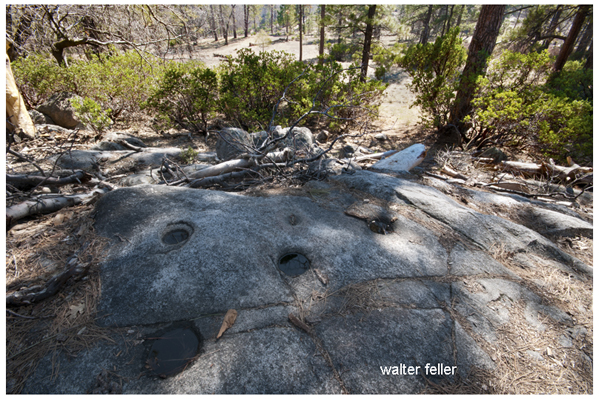
  3. Houses and Shelters: The Serrano traditionally lived in dome-shaped structures known as kish, which were constructed from a framework of willow branches covered with brush and reeds. These structures were well-suited to the climate of the region.
  4. Cultural Practices: The Serrano had a rich cultural and spiritual life, with ceremonies, rituals, and traditions that were closely tied to their environment. They believed in a variety of supernatural beings and spirits.
  5. Contact with Europeans: European contact with the Serrano people began with the arrival of Spanish explorers and missionaries in the late 18th century. Like many Native American groups, the Serrano experienced significant disruptions to their way of life due to the introduction of new diseases, cultural changes, and the influence of European settlers.
  6. Reservation: In the mid-19th century, as Euro-American settlers expanded into Southern California, the Serrano people faced displacement from their traditional lands. In the 20th century, some members of the Serrano Nation settled on the San Manuel Indian Reservation near Highland, California.
  7. Contemporary Issues: Today, the Serrano people, like many Native American communities, face challenges related to economic development, healthcare, education, and cultural preservation. Efforts have been made to revitalize cultural practices and traditions.

It’s important to note that the history and experiences of Native American tribes are diverse, and individual tribes have unique cultures, histories, and contemporary challenges.

Mojave Indians

https://mojavedesert.net/mojave-indians/

/blog/?p=4048

The Mojave people, also known as the Mohave or Mojave Indians, are a Native American group indigenous to the Colorado River basin, which spans parts of present-day California, Arizona, Nevada, and Utah.

Here are some key aspects of the Mojave Indians:

  1. Geography: The traditional homeland of the Mojave people includes the Mojave Desert and the Colorado River basin. They are closely associated with the Mojave Desert, a harsh and arid region with extreme temperatures.
  2. Language: The Mojave people traditionally spoke the Mojave language, part of the Yuman language family. Like many Native American languages, Mojave is endangered, with relatively few fluent speakers remaining today.
  3. Lifestyle and Subsistence: The Mojave were traditionally semi-nomadic people, adapting their lifestyle to the challenges of the desert environment. They engaged in hunting, gathering, and fishing along the Colorado River. The mesquite tree in the region was a crucial food source, providing beans ground into flour.
  4. Houses and Shelters: The Mojave traditionally lived in dome-shaped homes made from brush and other natural materials. These structures were called “káa nyava” or “a nyava.” In addition to these homes, temporary shelters were constructed during travels.
  5. Contact with Europeans: Like many Native American tribes, the Mojave encountered European explorers, missionaries, and settlers. Spanish missionaries established missions in the region in the 18th century. Europeans’ arrival significantly impacted Mojave society, introducing new technologies, trade goods, and diseases.
  6. Steamboats and Trade: In the 19th century, the Colorado River became an important transportation route for steamboats, facilitating trade. The Mojave people traded with non-Native groups, exchanging goods such as mesquite products, pottery, and woven items.
  7. Fort Mojave Reservation: The Fort Mojave Reservation was established in 1880 along the Colorado River, encompassing parts of Arizona, California, and Nevada. It is the home of the Fort Mojave Indian Tribe, which includes Mojave, Chemehuevi, and Navajo people.
  8. Contemporary Challenges: Like many Native American communities, the Mojave faces contemporary challenges, including issues related to economic development, healthcare, education, and cultural preservation. Efforts have been made to revitalize cultural practices and promote the community’s well-being.

As with any Native American group, it is important to recognize the diversity and uniqueness of Mojave culture and history. Individual experiences and traditions within the tribe can vary.

Chemehuevi Indians

The Chemehuevi are a Native American tribe that primarily resides in the southwestern United States, particularly in the states of California, Arizona, and Nevada. The name “Chemehuevi” is derived from their Mojave name, which means “those who play with fish.” They are closely related to the Southern Paiute people and have historical and cultural ties to other indigenous groups in the region.

Key points about the Chemehuevi Indians include:

  1. Location: Traditionally, the Chemehuevi inhabited the areas around the eastern shores of the Salton Sea in California, the Colorado River, and parts of Arizona and Nevada.
  2. Language: The Chemehuevi people speak the Chemehuevi language, which is part of the Numic branch of the Uto-Aztecan language family. However, today, only a few individuals still speak their native language fluently.
  3. Subsistence: Historically, the Chemehuevi were skilled hunters and gatherers. They relied on hunting game, fishing, and gathering wild plants for their sustenance. The availability of the resources in the arid region influenced their nomadic lifestyle.
  4. Contact with Europeans: Like many Native American tribes, the Chemehuevi encountered European explorers and settlers, including Spanish missionaries and later American pioneers. These interactions significantly impacted their way of life, introducing new technologies and diseases and disrupting traditional practices.
  5. Reservation: The Chemehuevi Reservation was established in the 1860s along the Colorado River. The Chemehuevi Reservation is located near Havasu Lake, California. This area is the primary home for the tribe today.
  6. Contemporary Issues: Like many Native American communities, the Chemehuevi face various challenges, including issues related to cultural preservation, economic development, healthcare, and education. The tribe has made efforts to preserve and revitalize their cultural heritage.

It’s important to note that the history and experiences of Native American tribes are diverse, and individual tribes have unique cultures, histories, and contemporary challenges.

Desert Food Chain

The desert food chain is a complex system involving various organisms interacting for energy and survival. Despite the harsh conditions of deserts, life has adapted to these environments, and a delicate balance exists within the food chain. Here is a simplified overview of the desert food chain:

  1. Producers:
    • Plants and Cacti: Deserts have specialized plants adapted to conserve water and thrive in arid conditions. Examples include cacti, succulents, and drought-resistant shrubs. These plants are primary producers, converting sunlight into energy through photosynthesis.
  2. Primary Consumers:
    • Herbivores: Insects, rodents, and small mammals feed on desert plants. Examples include grasshoppers, mice, and rabbits. These organisms are primary consumers that obtain their energy by consuming plants.
  3. Secondary Consumers:
    • Carnivores: Predators in the desert feed on herbivores. Examples include snakes, lizards, and birds of prey. Some mammals like foxes and coyotes also fall into this category, preying on smaller animals for sustenance.
  4. Tertiary Consumers:
    • Top Predators: Larger predators at the top of the desert food chain prey on herbivores and smaller carnivores. Examples include large birds of prey like eagles and apex predators like some species of big cats (e.g., cougars or cheetahs, depending on the desert region).
  5. Scavengers:
    • Scavengers: These organisms feed on the remains of dead animals. Scavengers play a crucial role in nutrient recycling in the desert ecosystem. Examples include vultures, hyenas, and certain types of beetles.
  6. Decomposers:
    • Microorganisms: Decomposers decompose organic matter, such as dead plants and animals, into simpler nutrients the soil can absorb. Bacteria and fungi are essential decomposers in the desert ecosystem.

Throughout this food chain, energy is transferred from one trophic level to the next, with each level being dependent on the level below for its energy source. Water is a limiting factor in deserts, and many organisms have adapted various mechanisms to conserve water or extract it efficiently from their food sources. The delicate balance of the desert food chain is essential for the survival of its inhabitants in these harsh environments.

Stagecoaches and Stage Routes in the Mojave Desert

In the 19th century, stagecoaches and stage lines were crucial in transportation across the American West, including the Mojave Desert. The Mojave Desert, located in the southwestern United States, spans parts of California, Nevada, Utah, and Arizona. Stagecoaches were an essential means of transportation for people and goods during this time, connecting remote areas and facilitating the westward expansion.

Key points about stagecoaches and stage lines in the Mojave Desert include:

  1. Butterfield Overland Mail Route:
    • The Butterfield Overland Mail Company operated one of the most famous stagecoach routes in the 1850s. The Butterfield Overland Mail Route ran from St. Louis, Missouri, to San Francisco, California, passing through the Mojave Desert. This route covered vast distances and was critical for mail delivery and passenger transport.
  2. Mojave Road:
    • The Mojave Road was a historic trade route later used by stagecoaches, connecting the Colorado River with the Mojave River. It was a challenging trail across the desert, and stagecoaches faced numerous obstacles, including extreme heat, lack of water, and rough terrain.
  3. Water Stops:
    • One of the significant challenges for stagecoach travel in the Mojave Desert was water scarcity. Stagelines had to plan their routes carefully, stopping at reliable water sources to replenish supplies for passengers and horses.
  4. Freighting and Passenger Service:
    • Stagecoaches served as freighting vehicles for goods and as a mode of passenger transport. Passengers endured long, uncomfortable journeys in the stagecoaches’ often cramped and sweltering conditions.
  5. Overland Trail Companies:
    • Various stagecoach companies operated in the Mojave Desert, providing services to different regions. These companies included the Pioneer Stage Line and the California Stage Company.
  6. Decline of Stagecoaches:
    • The rise of the transcontinental railroad in the late 19th century contributed to the decline of stagecoach travel. Railroads provided a faster and more efficient means of transportation, reducing the reliance on overland stagecoach routes.
  7. Historical Landmarks:
    • Some remnants of the old stagecoach routes and stations can still be found in the Mojave Desert, serving as historical landmarks. These sites provide a glimpse into the challenges early travelers face in the region.

Today, the legacy of stagecoaches and stage lines in the Mojave Desert is preserved in museums, historical sites, and the stories of the Old West. The Mojave Desert symbolizes the challenges and adventures faced by pioneers and travelers in the 19th century.

Ecosections

Ecosections, also known as ecological sections, are geographic subdivisions of a region based on its climate, landforms, and vegetation. In California, the state is divided into several ecosections, each characterized by unique ecological features. These divisions help in understanding and managing the diverse ecosystems within the state. Remember that the specific ecosection classification system may vary depending on the source. One commonly used system is the “California Ecological Units” classification. Here are some examples of ecosections in California:

  1. Sierra Nevada
    • Characterized by high mountain ranges, including the iconic Sierra Nevada.
    • Alpine and subalpine ecosystems, mixed conifer forests, and meadows.
  2. Southern California Mountains and Valleys
    • Encompasses the Transverse and Peninsular Ranges.
    • Chaparral, coastal sage scrub, and oak woodlands are common vegetation types.
  3. Central California Valley
    • Includes the expansive Central Valley, a major agricultural region.
    • Diverse agricultural landscapes, grasslands, and riparian ecosystems.
  4. Great Basin
    • Spans the northeastern part of California.
    • Sagebrush steppe, pinyon-juniper woodlands, and mountain ranges.
  5. Mojave Desert
    • It is located in the southeastern part of the state.
    • Characterized by desert landscapes with Joshua trees, creosote bush, and other desert plants.

These ecosections provide a framework for understanding the ecological diversity of California, which is crucial for conservation, land management, and environmental planning. It’s important to note that these descriptions are generalizations, and there may be ecosystem variations and overlaps within each ecosection.

Googie Architecture

Roy’s Motel & Cafe – Amboy, Ca.

Googie architecture is a distinctive architectural style that emerged in the mid-20th century in the United States. It is often associated with the design of roadside architecture, particularly diners, motels, gas stations, and other commercial buildings. The style is characterized by bold, futuristic, and space-age elements, reflecting the optimism and fascination with technology that prevailed during the post-World War II era.

Neon sign – Road Runner’s Retreat, 2001 – Route 66, Mojave Desert

Key features of Googie architecture include:

  1. Upswept Roofs and Dramatic Angles: Buildings often feature bold, upswept roofs, acute angles, and dynamic geometric shapes.
  2. Large Plate Glass Windows: Transparency and visibility were emphasized, with large windows often integrated into the design.
  3. Steel and Concrete Construction: The use of modern materials, such as steel and concrete, was common in Googie architecture.
  4. Atomic and Space Age Motifs: Elements inspired by the Space Age, atomic symbols, and futuristic motifs were frequently incorporated into the design, reflecting the cultural fascination with space exploration and technology.
  5. Neon Signs and Lighting: Bright and colorful neon signs were a hallmark of Googie architecture, contributing to a vibrant and attention-grabbing aesthetic.
  6. Futuristic Materials: The use of materials like Formica, plastic, and fiberglass, which were considered modern and cutting-edge at the time.
Hesperia Airport

Googie architecture reached its peak popularity in the 1950s and 1960s but declined in the subsequent decades. Nevertheless, it has left a lasting impact on popular culture and is celebrated for its whimsical and nostalgic qualities. Many examples of Googie architecture can still be found across the United States, particularly in areas that experienced significant suburban development during the mid-20th century.

Las Vegas, Nevada – 2005

Tulare Lake – Vanished

Many folks interested in Mojave Desert history are aware that in 1776, Francisco Tomás Hermenegildo Garcés was the first non-native American to cross the Mojave from the Mojave Indian villages near Needles at the Colorado River to the Mission San Gabriel near Los Angeles, California.  Trapper and explorer Jedediah Smith also crossed the Mojave in 1826 and in 1827.

Tulare Lake – 1874

Not so well known is that when they left the mission at San Gabriel, both men made their way north to the San Joaquin Valley and the shore of Tulare Lake.   In tracking the paths of both men concerning our modern geography, it is soon discovered that this lake does not seem to exist.

What happened to Tulare Lake?

The answer to this mystery of a disappearing lake is simple yet inelegant and predictable:

At the onset of American settlement in the area in the late 1840s, the lake was the largest body of fresh water west of the Great Lakes. Its destruction by the late 1800s because of diking and water diversion for irrigation was one of the most dramatic signs of a major theme in the state’s history: the rapid transformation of the wild California landscape into one dominated almost completely by human action.

From Report of the Board of Commissioners on the Irrigation of the San Joaquin, Tulare, and Sacramento Valleys of the State of California.

Tulare Lake Satellite Overlay 2018

So, now you know.

California High & Low Deserts

https://mojavedesert.net/ecology/

California is home to high and low deserts, characterized by distinct features, climates, and elevations. The primary differences between California’s high and low deserts include elevation, temperature, and vegetation.

Low Desert
High Desert
  1. Elevation:
    • High Desert: The high desert refers to areas at higher elevations, typically between 2,000 and 4,000 feet above sea level. Examples of high desert regions in California include the Mojave Desert. Cities like Lancaster and Palmdale are located in the high desert region.
    • Low Desert: The low desert, on the other hand, is found at lower elevations, often below 2,000 feet. The Colorado Desert, part of the larger Sonoran Desert, is an example of a low desert in California. Cities like Palm Springs and Indio are located in the low desert region.
  2. Temperature:
    • High Desert: High deserts generally experience greater temperature fluctuations between day and night. Summers can be hot, with daytime temperatures exceeding 100°F (37.8°C), while winters can be cool, with nighttime temperatures dropping significantly.
    • Low Desert: Low deserts tend to have higher average temperatures, especially during the summer. Daytime temperatures in the low desert areas can often surpass 100°F (37.8°C), and the winters are milder compared to the high deserts.
  3. Vegetation:
    • High Desert: Vegetation in the high desert is adapted to the arid conditions and includes hardy shrubs, grasses, and some cold-resistant plants. Joshua trees are a characteristic plant of the Mojave Desert.
    • Low Desert: The low desert is known for its unique plant life, including various species of cacti and succulents. The iconic saguaro cactus is commonly found in the lower elevations of the Sonoran Desert.
  4. Geography:
    • High Desert: The high desert often features rocky terrain and vast expanses of open land and is characterized by a mix of mountains, plateaus, and valleys.
    • Low Desert: The low desert may have more sandy and flat terrain, including areas with salt flats. Rugged mountains may also punctuate the landscape.

It’s important to note that these are generalizations, and there can be variations within each desert region. The specific characteristics can also vary depending on the exact location within California.