Standard Hill sits just south of Mojave, California. Today, it appears to be just another rocky desert butte, but for more than a century, people were convinced it was a golden hill.
It started in 1894 when George Bowers, a lone prospector, stumbled across gold in the rocks. His first load of ore was worth $1,600, a substantial sum back then. Word spread fast. Soon, miners were sinking shafts into veins with colorful names, such as Yellow Rover, Exposed Treasure, and Desert Queen.
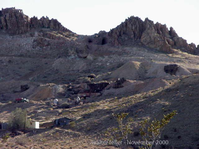
By 1901, the place wasn’t just a scatter of claims anymore. A big 20-stamp mill and a cyanide plant were built to crush and process the rock. What had been a lonely hill was suddenly alive with pounding stamps, the smell of chemicals, and the clatter of wagons hauling ore. A little company camp, called “Gold Town,” even grew at the base of the hill to house workers and families.
Mining boomed off and on for decades. Companies came and went—the Mojave Consolidated, Standard Mining and Milling, and later Standard Hill Mines Company. Each tried to pull wealth from the hill. In the 1930s, during the Great Depression, the district came roaring back to life. Miners chased the gold veins hundreds of feet down, working day and night until World War II shut them down by government order.
All told, Standard Hill yielded approximately $3.5 million worth of gold and silver in the past, primarily from the first three prominent veins. That’s roughly 170,000 ounces of gold, much of it in the form of bright yellow metal mixed with silver. People who worked in the mines said that some ore was so rich it sparkled in the sunlight.
The rock itself tells part of the story. Standard Hill is made of ancient granite capped with younger volcanic rock. When hot fluids moved through cracks in these rocks long ago, they left behind quartz veins stuffed with gold and silver. Miners followed these veins like treasure maps, finding pockets of ore several feet thick.
The hill wasn’t done yet. In the late 1980s, modern companies returned with bulldozers and leach pads, excavating four small open pits. They mined for just a few years before prices fell and the operation shut down again in the early 1990s.
Today, Standard Hill is quiet. You can still see old mine shafts, scattered ruins of the mill, and the scars of the modern pits. It’s a reminder of how one small desert hill fueled dreams of riches, supported little communities, and became part of California’s long gold-mining story.
Desert Fever: An Overview of Mining in the California Desert (Mojave Desert Mining History, Standard Hill section)
California Division of Mines and Geology, Mineral Resources of Kern County (1957; later summaries of Mojave-Rosamond District production and geology)
Mindat.org – Standard Hill Group (Mojave Mining District, Kern County, CA) – mindat.org/loc-219385.html
Elephant Butte – Standard Hill Group, Mojave Mining District, Kern County, California (technical geology report, academia.edu)
The Diggings – Standard Hill Mine (historical mining claim and production records) – thediggings.com/mines/28338
California Journal of Mines and Geology, 1930s–1940s issues (district reports with production figures and ore descriptions)
USGS Bulletins on Mojave District mineral deposits (notably reports describing epithermal systems of Soledad Mountain, Standard Hill, and Tropico Hill)
Lake Manix is an ancient lake in what is now the Mojave Desert of California, USA. It was part of the ancient Mojave River system, which flowed through the area during periods of the Pleistocene epoch when the climate was wetter than it is today. The presence of this lake is a testament to the dramatically different environmental conditions that prevailed in the region thousands of years ago.
Lake Manix
In its ancient course, the Mojave River fed into Lake Manix, creating a significant water body supporting diverse flora and fauna. This ancient river system was vital for migrating and sustaining animals and possibly early human populations. Over time, Lake Manix eventually dried as the climate became warmer, and the Mojave River’s flow diminished significantly. The remnants of this ancient river system can still be traced in the modern landscape of the Mojave Desert, with the Mojave River now flowing intermittently and largely underground.
Archaeological and geological evidence from the Lake Manix area provides valuable insights into the climatic changes that have occurred over millennia in the Mojave Desert. Studies of sediment deposits, fossil records, and other geological features around the former lake site help scientists reconstruct the paleoenvironmental conditions, offering clues about water availability, vegetation types, and the animals that once inhabited the region.
The transition from a wetter, lake-dominant landscape to the arid desert environment of today highlights the dynamic nature of Earth’s climate and ecosystems. Understanding the history of Lake Manix and the ancient Mojave River system contributes to our knowledge of past climatic shifts. It helps inform current and future conservation efforts in desert ecosystems.
Coyote Arm of Lake Manix
The Coyote arm of Lake Manix refers to a specific portion or segment of ancient Lake Manix, which existed during the Pleistocene epoch in what is now the Mojave Desert of California. This area is particularly interesting to geologists and archaeologists because it provides evidence of the extent of the lake and the environmental conditions that prevailed in the region.
Lake Manix covered a large area and had multiple “arms” or extensions, with the Coyote arm being one of them. These arms were parts of the lake that extended into different valleys or low-lying areas, filled by the ancient Mojave River and its tributaries. The existence of these arms indicates that the lake’s water levels and boundaries changed over time, influenced by climatic fluctuations, precipitation patterns, and river flow dynamics.
Studying the Coyote arm and other parts of Lake Manix helps scientists reconstruct the paleohydrology of the region. By examining sediment layers, fossil remains, and other geological features, researchers can infer past water levels, the timing of lake expansion and contraction, and the habitats around the lake. This information is crucial for understanding how ancient ecosystems responded to climate change and how they supported early human populations and other species.
Evidence from the Coyote arm and similar areas around the former Lake Manix also contributes to our understanding of the broader paleoclimatic patterns in North America. Such studies are part of a larger effort to piece together the history of Earth’s climate and how it has shaped the development of landscapes and ecosystems over geological time scales.
Troy Lake arm of Lake Manix
The Troy Lake arm of Lake Manix represents another significant segment of the ancient Lake Manix, which was a part of the extensive Pleistocene-age lake system in the Mojave Desert, California. Like the Coyote arm, the Troy Lake arm was one of the various extensions or branches of Lake Manix, fed by the ancient Mojave River and its tributaries during a time when the climate was considerably wetter than it is today.
The presence of the Troy Lake arm and other arms like the Coyote arm indicate the region’s complex hydrology and varied topography during the Pleistocene. These arms were essentially the lake’s extensions into surrounding valleys, creating diverse habitats for various plant and animal life. These lake arms’ fluctuating boundaries and water levels, driven by climatic variations, offer valuable insights into past environmental conditions.
Researchers study the Troy Lake arm and focus on sediment deposits, fossilized remains, and other geological indicators to understand the lake’s hydrology, such as water depth, extent, and changes over time. These studies contribute to a broader understanding of how ancient lake systems like Lake Manix responded to glacial and interglacial cycles, influencing precipitation patterns, temperature, and, ultimately, the region’s hydrography.
The research on the Troy Lake arm, alongside other parts of Lake Manix, is crucial for reconstructing past climates and ecosystems. It helps in understanding the challenges faced by early human settlers and the strategies they employed for survival. Moreover, it provides context for current environmental changes and aids in predicting future climatic shifts, especially in desert regions like the Mojave, which are sensitive indicators of broader environmental transformations.
Afton Canyon
/afton-canyon/
Afton Canyon, often called the “Grand Canyon of the Mojave,” is a striking geological feature in California’s Mojave Desert. It is renowned for its dramatic landscape, including steep canyon walls, rare desert waterways, and various wildlife. The formation of Afton Canyon is closely tied to the history of Lake Manix and the ancient Mojave River system.
During the Pleistocene epoch, when Lake Manix existed, it was a significant water body fed by the Mojave River, which carried meltwater from glaciers in the mountains to the north. Over time, the climate became drier, and the lake levels fluctuated. Eventually, Lake Manix breached its natural dam, leading to a catastrophic water outflow. This event was a pivotal moment in the formation of Afton Canyon.
The breach of Lake Manix’s dam caused a massive release of water that carved through the landscape, creating Afton Canyon. Rapid erosion cut deeply into the sediment and rock, forming the canyon’s distinctive steep walls. The force of the water was so powerful that it removed vast amounts of material, shaping the canyon into its present form.
Today, Afton Canyon remains one of the few places in the Mojave Desert where the Mojave River flows above ground, offering a rare glimpse into the water’s erosive power that shaped the landscape. The canyon’s formation is a testament to the dynamic geological processes that have occurred over millennia, driven by climatic shifts and water movement.
The role of Lake Manix in forming Afton Canyon highlights the interconnectedness of geological features within the Mojave Desert. It illustrates how ancient lakes, rivers, and climatic conditions have sculpted the region’s unique landscapes. Afton Canyon’s creation is a prime example of how water, even in arid environments, can be a powerful change agent, carving through the earth to create spectacular natural features.
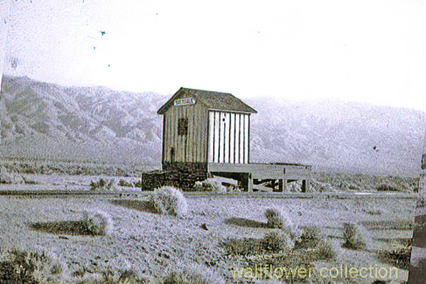
Koehn Lake and the nearby ghost town of Saltdale have a rich history intertwined with the salt industry in California. Koehn Lake, situated in the Fremont Valley of the Mojave Desert in eastern Kern County, California, is a dry and seasonally endorheic lake, occasionally becoming a closed basin without outflow. The lake is approximately 5 miles long and 3 miles wide at its widest point.
Saltdale, founded in 1915, owes its origins to the salt harvesting operations from Koehn Dry Lake. The town had a post office operating from 1916 to 1950. The history of salt production in the area began in earnest in 1914 with the operations of the Consolidated Salt Company. This was further expanded with the involvement of the Fremont Salt Company from 1919 to 1927, which also utilized solar evaporation of surface brine for salt production.
The salt industry in this region has undergone several changes in ownership and production methods over the years. In the early 20th century, salt production fluctuated considerably, largely dependent on rainfall and storm runoff to supply water for brine formation. Modern techniques involve pumping brine from wells and channeling it to ponds for evaporation, a process that takes about four months to form approximately 6 inches of salt.
Saltdale, during its peak, had a diverse community, including managers, skilled workers, and their families, as well as common laborers, often Latino Catholics. The town had facilities like a company store, a post office, a school, and a service station. Saltdale’s school, under the guidance of notable teachers, played a significant role in community life, including efforts towards “Americanization” by encouraging English language use and cultural integration.
However, Saltdale faced challenges due to its remote location and the fluctuations in the salt industry. The town experienced isolation, difficulties in accessing law enforcement and medical care, and was impacted by the economic conditions of the time, including the Great Depression.
The decline of Saltdale was marked by the eventual abandonment of the town by the 1970s. The salt operations also evolved, with less need for manpower due to modernization. Today, Saltdale stands as a ghost town, with the remnants of its past slowly eroding away in the salty landscape.
Koehn Lake, apart from its salt mining history, has also been used for various other purposes. At its northern end, there are evaporation ponds from the salt mining operation, and the rail siding at the former townsite of Saltdale has been used for offloading explosives. The area around the lake has also been used for testing by the Reaction Research Society and for a desert test track by Honda Motors. In 2014, it was notably the area where Virgin Galactic’s experimental spaceship disintegrated.
The history of Koehn Lake and Saltdale provides a unique glimpse into the industrial and community life of early 20th-century California, highlighting the challenges and adaptations of a community built around a natural resource.
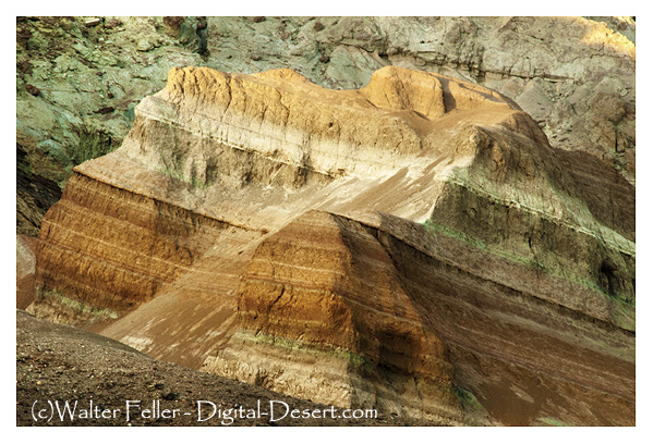
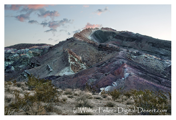
Rainbow Basin is a geological formation in the Mojave Desert of California. It is known for its unique and colorful rock formations, which provide valuable insights into the region’s geological history. Here are some key aspects of the geology of Rainbow Basin:
Sedimentary Rocks: Rainbow Basin primarily comprises sedimentary rocks accumulated over millions of years. These rocks include sandstones, shales, and mudstones. The different layers of sedimentary rocks represent different periods of geological history.
Fossilized Marine Life: Within the sedimentary rocks of Rainbow Basin, fossils of marine life from the Miocene epoch (approximately 15-20 million years ago) have been found. These fossils include shells, bones, and other remnants of ancient sea creatures. This suggests that a shallow sea once covered the area.
Faulting and Uplift: The geology of Rainbow Basin has been influenced by tectonic forces. The region is situated near the intersection of several fault lines, including the Garlock Fault. These fault movements have caused the uplift of the rocks, exposing them to erosion and creating the unique landscape seen today.
Erosion and Weathering: Over time, erosion and weathering have shaped the colorful rock formations in Rainbow Basin. These processes have created intricate patterns and exposed layers of colored sediments, giving the area its name.
Geological Time Scale: The rocks at Rainbow Basin span a significant portion of the geological time scale, providing geologists with valuable information about the changing environments and life forms that existed in the area millions of years ago.
Geological Tours: Rainbow Basin is a popular destination for geological enthusiasts and tourists interested in its unique geology. There are guided tours and interpretive exhibits that provide insights into the geological history of the area.
Rainbow Basin, Barstow, Ca.
In summary, Rainbow Basin is a geological wonder in the Mojave Desert, characterized by its sedimentary rocks, fossils, faulting, erosion, and vibrant colors. It offers a glimpse into the geological history of California and the forces that have shaped its landscape over millions of years.
This quake is remembered, and named after, its death toll: forty Native Americans attending mass at San Juan Capistrano were killed when the church collapsed due to the mortar in the walls failing. Records from this time are poor, but it is likely that there was also damage at Mission San Gabriel and in San Diego.
The Fort Tejon earthquake occurred on January 9, 1857, and is one of the largest historical earthquakes in California. It had an estimated magnitude of 7.9 and was associated with the southern segment of the San Andreas Fault
The 1952 Kern County earthquake occurred in southern California on July 21, 1952. This earthquake had an estimated magnitude of 7.3, making it one of the most powerful earthquakes in California’s history. The epicenter was near the White Wolf Fault in the southern Sierra Nevada mountain range.
The 1872 Owens Valley earthquake was a significant seismic event on March 26, 1872, in Owens Valley, California, USA. The earthquake is estimated to have had a magnitude of 7.4 to 7.9, making it one of the largest historical earthquakes in California.
The earthquake caused landslides that blocked the Lytle Creek Canyon road and the road through Cajon Pass. It also caused some damage to buildings in San Bernardino, Highland and Patton. Minor damage was also reported in Redlands, Pomona, Riverside, Pasadena and Los Angeles.
This quake was notable because it was the largest earthquake at that time—and the first to cause surface rupture (about three miles of rupture)—in the Mojave Block tectonic region.
Big Bear Earthquake
TYPE OF FAULTING: left-lateral strike-slip TIME: June 28, 1992 / 8:05:30 am PDT LOCATION: 34° 12′ N, 116° 49.6′ W 8 km (5 miles) SE of Big Bear Lake 40 km (25 miles) east of San Bernardino MAGNITUDE: MSS.4
DEPTH: 5 km
While technically an “aftershock” of the Landers earthquake (indeed, the largest aftershock), the Big Bear earthquake occurred over 40 km west of the Landers rupture, on a fault with a different orientation and sense of slip than those involved in the main shock — an orientation and slip which could be considered “conjugate” to the faults which slipped in the Landers rupture.
The Big Bear earthquake rupture did not break the surface; in fact, no surface trace of a fault with the proper orientation has been found in the area. However, the earthquake produced its own set of aftershocks, and from these, we know the fault geometry — left-lateral slip on a northeast-trending fault.
Following the Landers mainshock by three hours (it occurred while TV news coverage of the Landers earthquake was being broadcast live from Caltech), the Big Bear earthquake caused a substantial amount of damage in the Big Bear area, but fortunately claimed no lives. Landslides triggered by the jolt blocked roads in the San Bernardino Mountains, however, aggravating the clean-up and rebuilding process.
