Victor Valley Timeline

Combined timelines of Victorville, Hesperia & Apple Valley, CA.


Pre-1800s: Indigenous Presence and Trade

  • The Serrano and Vanyume tribes lived along the Mojave River, relying on the river’s intermittent flow for food and trade.
  • Trails used by these tribes would later become parts of the Mojave Road, Old Spanish Trail, and Salt Lake Road.

1850s–1870s: Pioneer Waystations and Early Ranching

  • 1858Aaron G. Lane establishes Lane’s Crossing on the Mojave River (present-day Oro Grande/Victorville area), offering rest and resupply to travelers heading west.
  • Lane is considered the first permanent American settler along the Mojave River.
  • Summit Valley, near present-day Hesperia, sees increased grazing by early ranchers.
  • The Summit Valley Massacre (1866): A conflict between settlers and Native groups over livestock thefts and land disputes—an often overlooked but significant local tragedy.

1880s: Railroads and Town Foundations

  • 1885: The California Southern Railroad, part of the Atchison, Topeka and Santa Fe system, reaches the High Desert.
  • A telegraph and railroad station named Victor is established, later renamed Victorville in 1901 to avoid confusion with Victor, Colorado.
  • Jacob Nash Victor, the railroad manager, is the town’s namesake.
  • The Hesperia Land and Water Company, led by James G. Howland, promotes Hesperia. It lays out plans for an agricultural colony and resort town, though irrigation plans fall short.

1900s–1930s: Modest Growth and Agriculture

  • Hesperia experiments with vineyards, orchards, and dairy farms, but water shortages and harsh conditions hinder success.
  • Victorville grows as a railroad shipping center and stopover for travelers crossing the desert.
  • The Victor Elementary School District is formed in 1906.
  • Early buildings still visible include the Hesperia Schoolhouse (Main St. and C Ave.).

1940s: War Changes Everything

  • 1941Victorville Army Airfield (later George Air Force Base) is established on the western edge of Victorville.
  • The base brings thousands of military personnel, rapid infrastructure growth, and federal investment.
  • Apple Valley remains mostly desert ranchland, but interest grows due to its mild climate and open space.

1948–1950s: Apple Valley Booms

  • 1948Apple Valley Inn opens, built by Newt Bass and Bud Westlund to attract investors and wealthy land buyers.
  • Stars like Bob HopeMarilyn MonroeJohn Wayne, and President Eisenhower stayed at the inn.
  • Murray’s Dude Ranch (founded earlier, 1920s–30s): One of the few Black-owned resorts in the country. It hosted African American guests during segregation and was used in Black-cast Western films.
  • Roy Rogers and Dale Evans purchase a ranch in Apple Valley and become its most notable residents, eventually opening Roy Rogers’ Apple Valley Inn.

1950s–1960s: Expansion and Identity

  • Hesperia Inn and the Hesperia Golf & Country Club try to rekindle resort dreams. Jack Dempsey, the former boxing champion, lends his name to a museum at the inn.
  • Victorville grows with new housing and infrastructure to support the military population.
  • Route 66 runs right through Old Town Victorville, lined with diners, motels, and neon signs.

1970s–1980s: Steady Growth and Cultural Legacy

  • Apple Valley becomes a desirable retirement destination, marketing itself as a “Better Way of Life.”
  • Civic leaders like Bud Westlund and Newton Bass help shape the town’s modern layout and community services.
  • The California Route 66 Museum opens in Victorville in a former café, preserving the highway’s local legacy.

1992–2000s: Transformation and Reinvention

  • 1992George Air Force Base closes under federal military restructuring, dealing a blow to Victorville’s economy.
  • The base is repurposed into Southern California Logistics Airport (SCLA), an international freight and aerospace hub.
  • Apple Valley, Hesperia, and Victorville begin to urbanize, growing into commuter towns for the Inland Empire and the Los Angeles area.

2000s–Present: Modern Challenges and Historic Preservation

  • Victor Valley College, founded in 1961, continues to serve the region.
  • Old Town Victorville Revitalization Project aims to preserve the historic downtown.
  • Apple Valley promotes its Western heritage through the Happy Trails Highway and events honoring Roy Rogers and Dale Evans.
  • Hesperia Lake ParkSilverwood Lake, and local trails draw new visitors and recreation seekers.

Bodie’s Notoriety

Timeline of major violent events and notorious moments in Bodie, California’s wild history — a town so lawless it earned a reputation as one of the roughest mining camps in the West:

1876 – Bodie’s Boom Begins
The Standard Mine strikes gold. Prospectors flood in, and Bodie transforms from a quiet camp into a booming town — and with it comes gambling, saloons, opium dens, and gunslingers.

1879 – Peak Population, Peak Violence
Bodie hits its peak with around 7,000–10,000 residents. That year alone, it’s said there were 30+ murders, many tied to gambling disputes and drunken shootouts. The phrase “Bad Man from Bodie” enters widespread use.

1879 – Tom Treanor Kills a Man in a Saloon
After a heated argument during a card game, Treanor guns down another miner in a crowded bar. He was arrested but later released after a murky trial. The town shrugs it off — just another night in Bodie.

1880 – Gunfight on Main Street
A broad daylight gunfight erupts between rival gamblers. Two men are killed, and several bystanders are wounded. This kind of event is common enough that locals don’t even bother locking their doors — they’re used to chaos.

1881 – James Stuart Lynched by a Mob
Caught robbing a stagecoach, Stuart is jailed in Bodie. That night, a group of vigilantes breaks in and hangs him from a telegraph pole. His body dangled for hours — a message to other would-be criminals.

1882 – Red Irwin Walks Free After Killing a Man
“Red” Irwin shoots another gambler in the back during a dispute. Witnesses testify, but the case is dismissed on a technicality. Irwin boasts about it in saloons afterward, reinforcing Bodie’s anything-goes culture.

1883 – Deputy Sheriff Shot in Line of Duty
Deputy John Kelly is killed while trying to break up a bar fight. His murder is never solved. By this point, even lawmen hesitate to enforce order in Bodie.

1884 – Town Begins to Decline
Mines starts to dry up. Many “bad men” drift elsewhere. But Bodie’s violent legend is cemented, passed down through newspapers, dime novels, and the stories of old-timers.

Polygonal Desiccation

This stuff cracks me up

Polygonal desiccation is a defining surface feature of many playas in the Mojave Desert, where cycles of flooding and drying repeatedly reshape fine-grained sediments. A playa is a dry lakebed that temporarily fills with water after rainfall, then dries under intense desert heat. In this setting, polygonal crack networks form as a direct response to the physical behavior of wet sediment losing moisture.

El Mirage

When a Mojave playa floods, water saturates surface layers composed mainly of clay and silt. These materials have a high capacity to retain water and expand slightly as they become hydrated. As conditions shift toward drying, driven by strong solar radiation and low humidity, evaporation removes water from the sediment. This loss of moisture causes the sediment to contract. However, because the surface layer is laterally constrained and cannot shrink uniformly, internal tensile stresses develop.

Once the stress exceeds the mechanical strength of the sediment, fractures begin to form. These cracks propagate downward and outward, intersecting with others to produce polygonal shapes. Over time, the network organizes into patterns that often resemble hexagons, with crack junctions approaching 120-degree angles. This geometry reflects a natural tendency toward stress minimization during shrinkage.

The scale of polygonal desiccation features on Mojave playas typically ranges from a few centimeters to several meters across, depending on factors such as sediment thickness, clay content, and drying rate. Finer-grained, clay-rich sediments tend to produce more well-defined and persistent crack networks, while coarser materials may result in less regular patterns.

These features are highly dynamic. Each flooding event can erase or modify existing crack networks, while subsequent drying generates new ones. Despite this constant reworking, similar polygonal patterns often reappear in the same areas because the underlying sediment properties and environmental conditions remain consistent.

In well-known Mojave sites such as Rogers Dry Lake and Soda Lake, polygonal desiccation is a routine and visually striking phenomenon. These surfaces provide valuable insight into sediment mechanics, evaporation processes, and environmental change. The presence, size, and morphology of crack networks can indicate recent hydrologic conditions, including the frequency and intensity of flooding events.

Broadwell Lake

It is important to distinguish polygonal desiccation from other polygonal patterns found in desert environments. In some playas, especially those rich in evaporite minerals, polygonal ridges form through salt accumulation driven by subsurface fluid movement rather than shrinkage. Additionally, very large polygonal features may reflect long-term groundwater decline rather than short-term drying.

In summary, polygonal desiccation on Mojave Desert playas represents a straightforward but powerful physical process: the contraction and fracture of drying sediment. These patterns are not random; they are systematic responses to environmental forces, and they serve as a visible record of the interplay between water, heat, and earth in arid landscapes.

A few distinct scenarios:

First, no infringement as a matter of law. This happens when the defendant’s conduct does not violate any exclusive right (for example, no copying, no distribution, etc.). In that situation, the plaintiff recovers nothing. The case is dismissed or judgment is entered for the defendant.

Second, lawful use defenses. Even if copying occurred, it may still not be infringement if it falls under doctrines like fair use or other statutory exceptions. In those cases, the use is legally permitted, so again, no damages. In fact, if the defendant prevails, the court may even award them attorney’s fees under Section 505.

Third, failure of proof. The plaintiff has the burden to prove infringement. If they cannot establish ownership of a valid copyright or copying of protected expression, the claim collapses. No liability, no damages.

Fourth, false or bad-faith claims. If someone wrongly accuses another of infringement, there can be consequences. For example, under the online liability provisions, knowingly misrepresenting that material is infringing can create liability for damages, costs, and attorney’s fees suffered by the accused party.

Finally, technical or de minimis use. Some uses are so trivial that courts treat them as non-actionable. If the copying is legally insignificant, it may not rise to infringement at all.

So the key point is this: damages—whether actual or statutory—are contingent on a valid infringement finding. Without that, the legal system treats the situation as if no wrong occurred, and the plaintiff gets nothing.

technical or de minimis use

“Technical” or de minimis use is a judicially developed limitation on copyright liability. It addresses situations where copying may have occurred in a literal sense, but the amount or significance is so trivial that the law does not treat it as actionable infringement.

The doctrine operates at the threshold question of copying. Copyright law does not prohibit all copying—only copying that is substantial enough to matter. If what was taken is negligible in quantity or qualitatively insignificant, courts may conclude there is no infringement at all.

There are two main dimensions courts consider.

First is quantitative triviality. If only a very small fragment of a work is copied, this may weigh toward a de minimis finding. However, small size alone is not decisive.

Second is qualitative significance. Even a short excerpt can be infringing if it captures the “heart” of the work. Conversely, copying a longer portion that is generic, unoriginal, or barely noticeable may still be treated as de minimis.

Courts often frame the test in perceptual terms: would an ordinary observer recognize the appropriation as meaningful? If the answer is effectively “no,” the use may be dismissed as de minimis.

This doctrine is distinct from fair use. Fair use assumes infringement but excuses it based on policy factors. De minimis use, by contrast, says the copying is too insignificant to count as infringement in the first place.

A few practical illustrations help clarify the boundary:

  • A fleeting, out-of-focus appearance of a copyrighted image in the background of a film scene is often treated as de minimis.
  • An unrecognizable or heavily altered fragment of audio may be considered trivial in some contexts (though sound recordings are treated more strictly in certain jurisdictions).
  • Copying a short phrase that is not itself protectable expression may also fall outside infringement entirely.

The strategic implication is important. If a defendant successfully argues de minimis use, the case ends before damages are even considered, because there is no legally cognizable infringement to remedy.

This pisses off some people.

Our First Amendment is a moral compass.

Santa Fe system

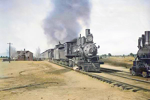
The Santa Fe system was the larger railroad network built around the Atchison, Topeka, and Santa Fe Railway and its affiliated or absorbed lines. It developed from a Kansas railroad chartered in 1859 into one of the principal transportation systems of the United States, especially across the Southwest and the Far West. In practical terms, the “system” extended beyond the parent company alone. It included the main line, subsidiaries, controlled properties, and feeder routes that together created a broad, coordinated structure for moving freight and passengers over great distances. By the late twentieth century, the Santa Fe system stretched across a wide territory and remained one of the country’s major Class I railroad networks.

Its historical importance lay in its effective organization of Western transportation. The system linked Midwestern origins with New Mexico, Arizona, California, and connections beyond, helping redirect trade and settlement patterns across the southern tier of the American West. It handled agricultural products, manufactured goods, livestock, minerals, and long-distance passenger traffic, and it became especially well known for both transcontinental freight service and high-grade passenger operations. The system’s reach also reflected the older railroad habit of expansion through subsidiary charters and later consolidation, so that lines first built under different corporate names were gradually brought into a unified operating structure.

In historical interpretation, the Santa Fe system is best understood as a networked institution rather than a single route. Its significance derived from continuity of movement across regions, from the Great Plains to the Pacific Coast. Even after the railroad’s independent corporate life ended in the 1990s, the Santa Fe system remained a defining framework for understanding western rail development and the long movement of commerce across the American interior and Southwest.

Atlantic and Pacific Railroad

The Atlantic and Pacific Railroad was an important nineteenth-century railroad enterprise conceived as part of a southern transcontinental vision, though it never fully realized that original plan. Congress incorporated it in 1866 to build a railroad stretching westward toward California, but the line was never finished as one continuous system under that name. Instead, the company came to own or operate separate sections, including an eastern segment connected with the St. Louis region and a western segment extending from Albuquerque to Needles. Because the middle portion was never completed, the Atlantic and Pacific became less a fully realized transcontinental railroad than a corporate and developmental bridge between earlier ambition and later railroad consolidation.

Its chief historical importance lies in its relationship to the Santa Fe. The Atlantic and Pacific provided a legal and corporate vehicle through which western construction could proceed, especially across New Mexico and toward California. In this sense, it served as a major precursor to the later Santa Fe system. What had been projected as an independent transcontinental line was gradually overtaken by the realities of railroad finance, incomplete construction, and strategic control by stronger carriers. The western portions ultimately became part of the Atchison, Topeka, and Santa Fe network, while other sections passed into different successor systems.

Historically, the Atlantic and Pacific Railroad illustrates a common pattern in nineteenth-century American railroading: ambitious federal charters, uneven construction, and eventual absorption into larger systems better able to finance, operate, and integrate long-distance rail service. Though the company itself did not endure as a dominant name, its western lines were indispensable in carrying railroad construction toward the Pacific slope and in laying groundwork for the Santa Fe’s rise as a major western carrier.

California Southern Railroad

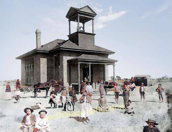
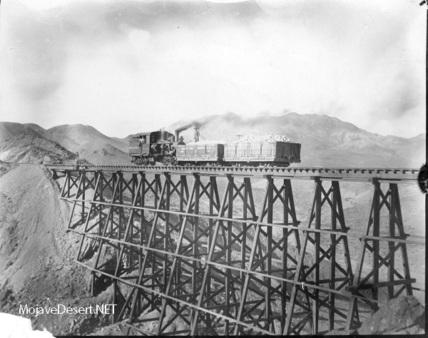
The California Southern Railroad was a subsidiary created to extend Santa Fe influence into Southern California during the decisive railroad contests of the 1880s. Organized in 1880, it was built to connect the San Diego area with inland Southern California and eventually with Santa Fe-controlled lines reaching eastward. Construction began from National City near San Diego and pushed north and northeast through communities including Oceanside, Temecula, Riverside, San Bernardino, and ultimately Barstow. In doing so, the line provided Santa Fe with an entry into a region long influenced by competing rail interests and opened the way for direct participation in Southern California transportation and commerce.

Its route was historically important because it was both strategic and difficult. The line crossed varied country, including the troublesome Temecula Canyon and the demanding grades of Cajon Pass. These were not merely scenic obstacles but operational challenges that required determined railroad engineering in an era when construction through unstable washes, steep mountain approaches, and remote inland stretches could determine whether a line prospered or failed. The completion of the route over Cajon Pass in 1885 allowed through trains tied to Santa Fe lines to reach Southern California, a turning point in the competitive reshaping of the region’s rail geography.

The California Southern did not remain independent for long, but its historical role was outsized. It helped break established transportation patterns, strengthened Santa Fe’s foothold in Southern California, and formed an essential part of the rail framework from which later Santa Fe operations in the region developed. In that sense, it was both a subsidiary and a foundational artery, carrying the larger system into one of the West’s most economically important regions.

Southern California Railway

The Southern California Railway was a later consolidating company created to rationalize and unify several Santa Fe-controlled properties in Southern California. Formed in 1889 through the consolidation of the California Southern Railroad, the California Central Railway, and the Redondo Beach Railway, it was further reorganized in 1892 through the addition of other affiliated lines, including the Santa Fe and Santa Monica Railway and the San Bernardino and Eastern Railway. In substance, it represented the next corporate stage in Santa Fe’s effort to turn a collection of separately chartered local and regional railroads into a more coherent Southern California network.

Its historical significance lies less in an individual main line than in the logic of consolidation. Nineteenth-century railroads often expanded through subsidiaries, local charters, and special-purpose corporations, but such arrangements could become cumbersome. The Southern California Railway gave Santa Fe a more orderly structure for managing routes serving Los Angeles, San Bernardino County, coastal connections, and outlying branches. It therefore stands as a representative example of how railroad systems matured: first by aggressive extension, then by administrative consolidation and operational integration.

By 1906, all of the Southern California Railway’s lines were deeded to the Atchison, Topeka, and Santa Fe Railway, confirming that the company had served primarily as an intermediate corporate instrument in the making of the larger Santa Fe system. Its importance is thus historical and structural. It marks the point at which Santa Fe’s scattered Southern California properties were drawn together into a more unified regional network, preparing the way for long-term operation under the parent railroad’s name.

Atchison, Topeka, and Santa Fe Railway

The Atchison, Topeka, and Santa Fe Railway was one of the great railroad companies of the United States and the core of what became known as the Santa Fe system. Chartered in Kansas in 1859, it was first conceived as a line serving Atchison, Topeka, and Santa Fe, reflecting the commercial logic of the Santa Fe Trail. It expanded rapidly westward and southward, becoming a major force in the settlement and economic integration of the Southwest. Britannica notes that it exercised great influence on the development of that region, and over time, it grew from a plains railroad into one of the country’s largest carriers.

The railroad’s historical strength lay in both geography and administration. It built and controlled lines reaching across Kansas and Colorado into New Mexico, Arizona, California, and other western territories, while also absorbing or directing subsidiary properties that extended its reach. It became a principal mover of freight across the southern transcontinental corridor and an important passenger carrier. By the twentieth century, the Santa Fe name carried national weight, associated with both long-distance commerce and distinctive passenger service. At the time of its merger into BNSF, the railroad had more than 13,000 miles of track, a measure of its scale.

The Atchison, Topeka, and Santa Fe Railway is historically significant not only because it was large, but because it gave organizational form to western rail development. It linked plains, desert, and Pacific markets in a manner that was commercially durable and strategically far-reaching. Even after its separate corporate identity ended through merger in 1995–1996, it remained one of the defining names in American railroad history.

Southern Pacific system

The Southern Pacific system was one of the largest and most influential railroad networks in the American West. More than a single line or company in the narrow sense, it served as an interconnected transportation system linking California with the Southwest, the Gulf Coast, and important inland markets. Its significance rested in scale, reach, and integration. Through a web of trunk lines, feeder routes, and affiliated railroads, the system carried agricultural products, minerals, manufactured goods, and passengers across vast distances that had once been slow and difficult to traverse.

In California, especially, the Southern Pacific system became deeply intertwined with the state’s economic development. It connected farming districts to urban centers, ports to inland communities, and remote resource regions to national markets. The railroad’s influence extended beyond transportation. It shaped town growth, industrial siting, and trade patterns, and for decades, it was regarded as one of the dominant corporate forces in Western life. Its lines were engineered across deserts, valleys, mountain passes, and coastal corridors, demonstrating the practical, expansion-minded railroad building of the late nineteenth and early twentieth centuries.

The term “Southern Pacific system” also implies an operational philosophy: a coordinated network designed for continuity of movement rather than isolated local service. Routes feed into one another, allowing freight and passengers to move efficiently between regions. As a result, the system helped define the geography of western rail transportation. Even after later mergers and corporate changes, the historic Southern Pacific system remained a benchmark for understanding how a railroad could organize and sustain the development of an entire region.

Southern Pacific

Southern Pacific was one of the most important railroad companies in American history, especially in the Far West. Over time, it grew from a California-centered carrier into a major transportation enterprise whose lines stretched across multiple states and connected with national rail corridors. Its name became synonymous with western railroading, not merely because of its mileage, but because of the influence it exerted on commerce, settlement, agriculture, and industry. In practical terms, Southern Pacific provided the infrastructure that enabled people and goods to move reliably across regions marked by long distances, harsh terrain, and uneven development.

In California, Southern Pacific held a particularly strong position. It served major cities, inland valleys, ports, farming districts, and desert crossings, making it indispensable to both local and long-haul traffic. The company moved fruit, vegetables, oil, lumber, livestock, and general freight, while also handling passenger travel on important intercity routes. Its locomotives, depots, yards, bridges, and main lines became familiar features of western life. Just as important, Southern Pacific was known for building and maintaining routes through difficult country, including mountain grades and arid stretches where rail service required careful planning and steady capital investment.

Historically, Southern Pacific was also a symbol of the era when railroads stood at the center of economic life. It could be praised as a builder of regional prosperity and criticized as an overbearing corporate power; both views reflected its enormous reach. By the twentieth century, it had become a defining institution of Western transportation. Though its corporate identity eventually disappeared through merger, the historical Southern Pacific remains central to any serious account of rail development in the American West.

Southern Pacific Mojave-Needles line

The Southern Pacific Mojave-Needles line was an important desert railroad route in southeastern California, forming part of the company’s broader eastern connections. Running across the Mojave Desert toward the Colorado River region, the line served as a strategic link between inland California and territories farther east. In railroad terms, such a line was valuable not only for local service but for through traffic, because desert routes could provide direct, comparatively efficient passage where terrain permitted. The Mojave-Needles line, therefore, belonged to the class of hard-working western main lines that combined geographic severity with operating importance.

Its setting gave the line a distinct character. Unlike routes passing through major urban districts or fertile valleys, this line crossed austere country marked by long distances, sparse settlement, extreme temperatures, and heavy dependence on rail infrastructure itself. Water supply, maintenance, and reliable operations were crucial in such an environment, particularly during the steam era. For freight service, the route played a role in moving goods between California and points east, while also serving mining districts and desert communities whose economic life depended on dependable rail access.

Historically, the Mojave-Needles line illustrates the practical reach of Southern Pacific’s western network. It was not merely a branch of local curiosity, but part of the larger fabric that bound California to interstate rail commerce. Lines like this helped make long-haul freight movement possible across the Southwest and reinforced the railroad’s dominance in desert transportation before the rise of modern highway trucking and interstate highways. The route stands as a representative example of western railroad engineering and operation: a line driven across difficult country for the sake of continuity, utility, and connection between distant markets.

Southern Pacific San Joaquin Valley-Los Angeles line

The Southern Pacific San Joaquin Valley-Los Angeles line was a crucial internal California route, linking the productive agricultural heartland of the San Joaquin Valley with the vast urban and commercial center of Los Angeles. In functional terms, this connection was indispensable. It allowed farm output, livestock, processed goods, and general freight from the interior valley to move southward into one of the state’s largest markets and distribution centers. At the same time, it supported passenger movement and helped tie together two very different but deeply interdependent regions of California.

The importance of this line lay in its economic geography. The San Joaquin Valley was among the most productive farming regions in the country, while Los Angeles developed into a major center of industry, trade, and population. A direct, reliable railroad connection between them was therefore essential to the orderly movement of goods. Southern Pacific used such lines to knit the state together, channeling agricultural traffic to urban consumers, processors, and warehouses, and connecting them to other lines. In earlier eras, especially before highways assumed their modern role, rail service on routes of this kind was foundational to statewide commerce.

The line also reflected Southern Pacific’s long-standing strength in California route structure. Rather than operating disconnected segments, the company maintained a coherent network in which valley, coastal, desert, and metropolitan lines complemented one another. The San Joaquin Valley-Los Angeles line exemplified that network logic. It was both a regional artery and a component of broader system operations. Historically, it represents the kind of practical railroad corridor that mattered every day: not dramatic in the manner of a transcontinental crossing, but vital in sustaining the ordinary commercial life that built modern California.

Desert Literature of the Mojave and American Southwest

The deserts of California and the greater Southwest have produced a distinct body of writing shaped by aridity, distance, scarcity, and endurance. This literature does more than describe the landscape. It records how people have understood, moved through, depended on, and argued about dry country. In the Mojave system and its adjoining regions, literature serves as evidence, showing how the desert has been interpreted over time.

Mary Austin
Mary Austin stands at the foundation of desert literature in the American West. In The Land of Little Rain (1903) and The Country of Lost Borders (1909), she described the Mojave, Owens Valley, and eastern Sierra as living systems shaped by water, ecology, and long human presence. Her work established the desert as a place of complexity rather than emptiness.

W. A. Chalfant
W. A. Chalfant represents the historical record of the desert borderlands. Through his work on Owens Valley and Inyo County, especially The Story of Inyo (1922), he documented settlement, mining, agriculture, and the major water conflicts tied to the Los Angeles Aqueduct. His writing anchors the desert in documented civic and regional history.

Edna Brush Perkins
Edna Brush Perkins brings the experience of movement through the desert into focus. In The White Heart of Mojave (1922), she recorded her travels across open desert country, emphasizing distance, silence, exposure, and the psychological effects of arid landscapes. Her work preserves what it felt like to cross the Mojave when the land still imposed strict limits.

Joseph Wood Krutch
Joseph Wood Krutch marks a shift toward ecological understanding. In The Desert Year (1951), he described the seasonal rhythms of desert plants and animals, portraying the desert as a balanced, functioning natural system. His work helped move public perception away from the idea of the desert as barren and toward recognition of its internal order.

Edward Abbey
Edward Abbey represents the modern phase of desert literature, where preservation becomes central. In Desert Solitaire (1968), he argued against overdevelopment, excessive access, and the industrialization of wilderness. His writing reframes the desert as something to be defended, not simply explored or used.

Together, these writers form a complete cultural layer for understanding the Mojave and the broader desert Southwest. Their work complements geology, ecology, transportation, and settlement history by providing a record of how the desert has been observed, experienced, documented, and contested.

1. “How to Overthrow the System: brew your own beer; kick in your Tee Vee; kill your own beef; build your own cabin and piss off the front porch whenever you bloody well feel like it.”

2. “The idea of wilderness needs no defense, it only needs defenders.”

3. “Life is too short for grief. Or regret. Or bullshit.”

4. “Freedom begins between the ears.”

5. “I’ve never yet read a review of one of my own books that I couldn’t have written much better myself.”

6. “Belief? What do I believe in? I believe in sun. In rock. In the dogma of the sun and the doctrine of the rock. I believe in blood, fire, woman, rivers, eagles, storm, drums, flutes, banjos, and broom-tailed horses…”

7. “In the first place you can’t see anything from a car; you’ve got to get out of the goddamned contraption and walk, better yet crawl, on hands and knees, over the sandstone and through the thornbush and cactus. When traces of blood begin to mark your trail you’ll begin to see something, maybe. Probably not.”

8. “This is the most beautiful place on Earth. There are many such places. Every man, every woman, carries in heart and mind the image of the ideal place, the right place, the one true home, known or unknown, actual or visionary.”

9. “I have been called a curmudgeon, which my obsolescent dictionary defines as a ‘surly, ill-mannered, bad-tempered fellow’. Nowadays, curmudgeon is likely to refer to anyone who hates hypocrisy, cant, sham, dogmatic ideologies, and has the nerve to point out unpleasant facts and takes the trouble to impale these sins on the skewer of humor and roast them over the fires of fact, common sense, and native intelligence. In this nation of bleating sheep and braying jackasses, it then becomes an honor to be labeled curmudgeon.”

10. “A world without open country would be universal jail.”

The Borax Machine

Borate, Marion, and Daggett are best understood not as separate curiosities, but as three parts of one late nineteenth-century borax machine. Borate was mined in the Calico district. Marion was the crushing and calcining plant that handled treatment and transfer. Daggett was the rail junction and shipping outlet where desert production met the wider market. That is why the formal railroad name remained the Borate and Daggett Railroad even though Marion stood near the operational center of the system. The California historic record identifies Marion as a Pacific Coast Borax crushing and calcinating plant established in 1898, while another historic registration summary describes the Borate and Daggett line as spanning about 11 miles, narrow gauge from Borate to Marion and standard gauge beyond.

The system grew out of a transport problem. Once Francis Marion Smith shifted attention from the older Death Valley borax works to the richer colemanite deposits near Borate, ore had to be moved efficiently across difficult ground to a railroad outlet. Cindy Baker’s history of Daggett says Smith moved his operations from Harmony Borax Works to Daggett, opened mining at Borate, used twenty-mule teams to haul borax to the processing works at Daggett, and then replaced the mule haul with the Borate and Daggett Railroad. The same source describes Daggett during the borax years as a hub of shipping and transfer activity.

There is a small dating tension in the surviving sources, and it is worth keeping rather than smoothing over. Baker places the railroad in 1896, while the California Historical Record lists the Marion plant as built in 1898. The safest reading is that the Borate-Marion-Daggett rail and processing system took shape in the late 1890s, with the railroad and plant representing one integrated industrial build-out rather than three disconnected events. In historical writing, that is the cleaner way to respect both citations without forcing a false precision.

What makes the system important in Mojave terms is that it marks a transition from wagon-borax to rail-borax. The older heroic image of desert haulage did not disappear by legend alone; it was displaced by a tighter industrial corridor in which mine, mill, and junction were coordinated. Borate became the country’s chief producer of borax and boracic acid from 1890 to 1907, according to the Death Valley historic resource study, but the district was never the end of the story. As Smith’s attention turned toward the Lila C and the Tonopah and Tidewater reached Death Valley Junction in 1907, Borate was abandoned, and its equipment moved on.

Seen this way, Borate, Marion, and Daggett form a hinge point in Mojave industrial history. Borate supplied the ore, Marion gave the system its processing heart, and Daggett connected the entire enterprise to the transcontinental freight world. The line was short, but its historical value is larger than its mileage because it shows exactly how the Mojave’s extractive economy moved from freighting tradition into a coordinated rail industry.

Daggett

Mojave Desert.net Project Skills

Essential Smoke & Mirrors

For your project, the most useful knowledge is not just “desert history” in a broad sense. The real strength comes from fields that explain how land, water, movement, and human use fit together.

The highest-value fields:

  1. Historical geography.
    This is probably the single best umbrella field for your work. It lets you connect routes, settlements, springs, railroads, mining districts, passes, and change land use across time. Your project is already built around corridors, nodes, and regional structure, so historical geography gives the whole thing coherence.
  2. Geology and geomorphology.
    These explain why the Mojave looks and functions the way it does. Basin formation, faulting, alluvial fans, playas, dunes, volcanic fields, canyon cutting, and erosion patterns all shape where travel, settlement, water, and industry happen. This field gives your project a physical backbone.
  3. Hydrology.
    For a Mojave project, water is destiny. Springs, intermittent rivers, sink systems, groundwater, pluvial lakes, flood channels, and dry lake basins all matter. Hydrology helps explain why camps, roads, ranches, mines, and towns appeared where they did and why some vanished.
  4. Archaeology.
    This gives depth before the wagon-road and railroad eras. It helps place Indigenous occupation, trade corridors, seasonal use, rock art, settlement patterns, and long-term human adaptation into the landscape rather than treating history as if it began with Euro-American travel.
  5. Ethnography and ethnohistory.
    These are essential because they keep the project from becoming only a transportation-and-settlement story. They help you understand Native place use, regional exchange, plant knowledge, movement patterns, and cultural landscapes in a more grounded way.
  6. Environmental history and historical ecology.
    These help track how people and landscapes have changed over time. Grazing, mining, railroads, reservoirs, exotic species, tourism, military use, conservation, and park-making all fit here. This field is especially useful for tying natural and human history together.
  7. Transportation history.
    This is already one of your strongest existing lanes. Wagon roads, trails, rail corridors, depots, highway realignments, and interstates are central to your project. This field helps explain movement, logistics, and corridor succession.
  8. Cartography and GIS.
    Even if used simply, these are extremely valuable. Your project is structural by nature, so maps are not decoration – they are evidence. Good spatial thinking will strengthen every page, especially the corridor, basin, and node pages.
  9. Archival research and source criticism.
    This is what keeps the project honest. Knowing how to weigh maps, reports, local histories, memoirs, newspapers, surveys, and agency documents will protect you from drift, folklore creep, and repeated errors.
  10. Public history and interpretation.
    This matters because your work is not just research – it is a presentation. You are building something people can read and navigate. Public history helps turn hard material into a clear, usable interpretation without flattening it.

The best supporting fields for your project are paleontology, biogeography, literary studies, photography, and design/illustration. These may not be the main frame, but they add texture, visual force, and cultural reach.

If I had to rank the most beneficial fields overall for your project, I would put them in this order: historical geography, geology/geomorphology, hydrology, archaeology/ethnohistory, transportation history, and cartography.

In plain terms: geology tells you what the land is, hydrology tells you how it works, archaeology tells you who used it earliest, transportation history tells you how movement changed it, and historical geography ties the whole system together.

how about for system design and html coding?Thought for a few seconds

Yes. For your project, system design and HTML coding are not side skills. They are part of the structure that makes the whole thing usable.

For system design, the most helpful knowledge areas are these:

  1. Information architecture.
    This is one of the most important. It helps you decide how pages relate to one another: system -> spine -> corridor -> node -> site-core -> support page. For your project, this is what prevents drift, duplication, and orphan pages.
  2. Taxonomy and classification design.
    You have a large body of material across geology, railroads, hydrology, Indigenous corridors, parks, towns, and sites. Good taxonomy helps you decide what belongs where, what counts as a parent page, what should be a child page, and what should just be a support note.
  3. Navigation design.
    Your project depends on people being able to move through it logically. This includes breadcrumb structure, related-page logic, index pages, thematic indexes, and cross-links that are controlled rather than random.
  4. Content modeling.
    This is the discipline of deciding what a page type contains. For example, every corridor page gets geography, early travel, rail development, highway era, connections, and significance. Every site-core page gets settings, history, physical context, and related nodes. This makes the site scalable.
  5. Editorial systems thinking.
    This matters a great deal to you. It means building rules for page identity, length, split triggers, naming conventions, citation handling, and maintenance. In old-fashioned terms, it is the difference between a library and a junk drawer.
  6. Database thinking, even without a formal database.
    Even if the site is mostly hand-built HTML, it helps to think in structured fields: title, alternate names, district, corridor, period, themes, related nodes, sources, coordinates, tags. That mindset makes later expansion far easier.
  7. User experience design.
    Not modern fluff – plain practical usability. Can a reader tell where they are? Can they move outward or inward from a page? Can they find rail pages separate from ecology pages? Can they tell the difference between a corridor and a town? That is UX.

For HTML coding, the most useful fields are these:

  1. Semantic HTML.
    Very important. Use proper headings, lists, paragraphs, nav, article, section, figure, footer, and so on. This gives pages a clear structure, improves accessibility, and makes the site easier to maintain.
  2. CSS layout and visual hierarchy.
    Even if the site stays simple, you need control over spacing, headings, sidebars, image captions, quote blocks, and metadata. Good CSS makes an old-style content site feel solid rather than cluttered.
  3. Accessibility.
    This is underrated and highly useful. Clear heading order, alt text, readable contrast, keyboard-friendly navigation, and sensible link text all improve the site for everyone, not just assistive users.
  4. Responsive design.
    Your pages should still work well on phones and tablets without becoming messy. This does not require flashy modern design. It requires dependable layout rules.
  5. Basic SEO and metadata structure.
    Title tags, meta descriptions, canonical thinking, heading hierarchy, internal links, and clean page focus all help search engines understand what each page is about. For a large historical site, that is important.
  6. Front-end performance.
    Lean pages, properly sized images, limited scripts, and clean markup matter. A project like yours benefits from fast-loading, durable pages more than from heavy interactive features.
  7. Template design.
    This may be the single most useful coding habit for you. Build repeatable page templates for corridor pages, site-core pages, timeline pages, district indexes, and bibliography/support pages. That gives the whole site consistency.

If I were ranking the most valuable knowledge for your project specifically, I would put them like this:

For system design:
information architecture, content modeling, taxonomy, navigation design, editorial governance.

For HTML coding:
semantic HTML, CSS layout, accessibility, responsive design, metadata/SEO, performance.

In plain terms, system design decides what the project is, while HTML decides how clearly that structure is expressed on the page.

For your particular project, the strongest path is probably this:

Build the system like an archive.
Build the navigation like an atlas.
Build the HTML like a durable reference site.

That approach fits your material better than chasing trendy web design.

How about for photography and map graphiicsThought for a couple of seconds

Very much so. For your project, photography and map graphics are not decoration. They are evidence, orientation, and interpretation.

Photography helps most when it draws from these knowledge areas:

  1. Documentary photography.
    This is probably the best fit. It teaches you to record a place clearly and honestly: what is there, its condition, how it sits in the landscape, and what details matter. For site-core pages, this is gold.
  2. Landscape photography.
    Useful not just for beauty, but for scale, landform, weathering, basin structure, passes, washes, dunes, rail grades, and settlement setting. A good landscape photograph can explain geography faster than three paragraphs.
  3. Architectural and vernacular-structure photography.
    Very important for depots, cabins, mining ruins, roadside remains, ranch structures, bridges, culverts, retaining walls, and old commercial buildings. This helps you show how people actually occupied and modified the desert.
  4. Field documentation methods.
    This means knowing how to photograph a site systematically: wide shots, mid-range context shots, close-up details, orientation views, approach views, inscriptions, construction materials, damage, and surroundings. Old survey habits still work because they are sensible.
  5. Visual storytelling.
    A single image is useful, but a sequence is stronger. For example: approach to a site, site in setting, key feature, detail, then outward view showing its corridor relationship. That turns photos into interpretation.
  6. Lighting and seasonal awareness.
    In the desert, light can make or ruin a photograph. Early and late light bring out relief, texture, trail traces, rock art surfaces, ruins, and fault scarps. Midday light often flattens everything into mush.
  7. Basic photo editing and archival practice.
    Not flashy effects. Just careful cropping, exposure correction, color restraint, file naming, captions, dates, and location notes. This keeps the image library useful over time.

For map graphics, the most helpful fields are these:

  1. Cartography.
    This is the big one. Cartography teaches selection, hierarchy, scale, labeling, symbol use, and clarity. A map should answer a question, not merely exist.
  2. GIS thinking.
    Even if you are not running a full GIS workflow every day, thinking in layers is extremely useful: hydrology, railroads, roads, ecosections, protected lands, settlements, faults, mining districts, Indigenous corridors. That matches your whole project structure.
  3. Relief and terrain interpretation.
    You work in a landscape where topography matters constantly. Passes, basin edges, fans, playas, escarpments, springs, and canyon mouths all become clearer when you know how to show terrain well.
  4. Historical cartography.
    Very valuable for your project. It helps you compare older routes, naming conventions, settlement shifts, rail alignments, and vanished places against the modern landscape. This is one of the strongest ways to show continuity and change.
  5. Diagram design.
    Not every map has to be geographically exact in the same way. Some of your best project graphics may be system diagrams: spines, corridor relationships, node hierarchies, basin connections, transport succession. Those are part map, part explanatory diagram.
  6. Labeling and annotation.
    This is more important than many people think. A good label can quietly teach geography. A bad one can clutter the whole page and turn a strong map into a headache.
  7. Color and contrast control.
    Maps need discipline. Too many colors, line types, textures, and labels can bury the point. For your work, restrained palettes and clear hierarchy would probably serve better than modern overdesigned map styling.

For your project specifically, photography is strongest when it does four jobs:
show setting,
show evidence,
show condition,
show relationship to the wider corridor or basin.

Map graphics are strongest when they do four jobs:
locate,
compare,
connect,
simplify.

So if I rank the most beneficial knowledge areas for each:

For photography:
documentary photography, field documentation, landscape composition, architectural recording, and archival captioning.

For map graphics:
cartography, GIS/layer thinking, historical cartography, terrain representation, diagram design.

In practical terms, your project would benefit a lot from building two consistent visual systems.

First, a photography system:
site overview,
approach view,
key feature,
detail shot,
outward context view.

Second, a map system:
regional locator map,
corridor map,
node map,
site detail map,
system diagram.

That would give the whole project a steady backbone. The old rule still holds: a good photograph shows what was there, and a good map shows why it matters.

This is a list of things I have learned throughout my varied technical career and interests that have led me to do what I do the way I do. God Bless America and the First Amendment.