Argali

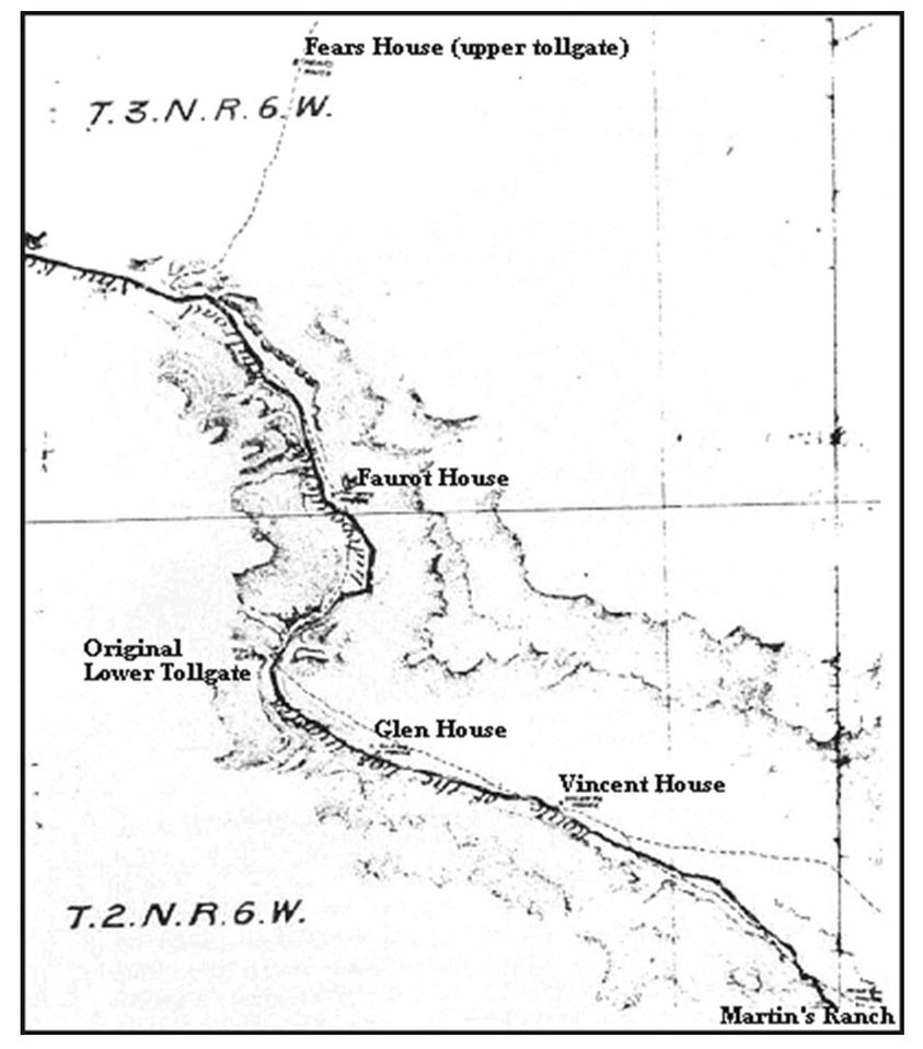
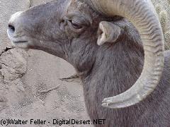
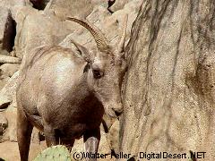
The way our language changes, develops, and reaches back fascinates me. Those animals had to be called something before proper names were defined and decided upon. So probably before Ovis canadensis was made legitimate, at least three common people commonly agreed to call what was then called an Argali, a bighorn sheep, an Argali is what it may have commonly been called.

From; A Pictorial History of California – Frost 1851

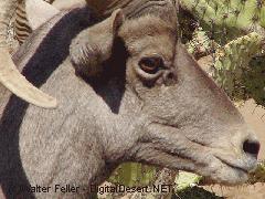
The Argali Ovis Moritanoe is found in California, sometimes called the Rocky Mountain Sheep.

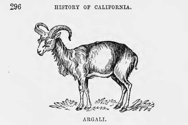
By some, the goat of the Rocky Mountains has been confounded with this animal; and it has also been called an antelope, though it is neither the one nor the other, but truly and properly a goat. The characters of this species, or probably variety (for it really seems that, notwithstanding all the diversities of the genus (his, whether in the wild or the cultivated state, there is no well-made out distinction broader than that of variety,) are very apparent and at once prevent any possibility of confounding it either with the antelopes or the goats, though of course, as all sheep do, it approximates more closely to the latter of these than to the former. The body is remarkable for its thickness and roundness in proportion to its length; the legs are very long; the outline of the forehead, seen in profile, is nearly straight; and the muzzle is almost exactly that of the common sheep.

The male’s horns are thick and large; they advance in front of the eyes and form nearly an entire spiral turn. They are flattened laterally like the domestic ram and have similar transverse furrows and ridges. These furrows and ridges are very conspicuous on the basal half of the length of the horn, but much less so on the terminal half, and of the three lateral faces, the front one is the largest.

The horns of the female are much more slender than those of the male; they are compressed, nearly straight, and without furrows; there are, in some instances, plates or folds of skin under the throat, especially in the male; the tail is very short in both sexes; the color in summer is generally grayish fawn, with a reddish or yellowish line down the back, and a large patch of the same color -on the buttocks; and the under part, and the insides of the legs are either russet, yellowish, or of a white sand color; in winter, the color of the upper part is more reddish, and the throat and breast are more inclining to white; but the patch on the buttocks remains much the same at all seasons.

These animals are found in little flocks, of about twenty or thirty in each, on the Rocky Mountains and extending southward as far as California. Several naturalists have expressed their conviction that the mouflon of the south of Europe, the Argali of Asia, and the wild sheep of America, are only climatal varieties of one great species, to which they have given the name of “mountain sheep;” but whether this is or is not positively the fact, we have no means of ascertain ing. Probability is in favor of it, however, and the more so that, among the domesticated sheep, which we have every reason to believe are all originally of the same stock, whatever that stock may have been, there are differences of external appearance fully greater than any which are to be met with among the wild ones; and we believe that, in the whole genus, there are no differences but external ones. Some further confusion and uncertainty are produced among these wild sheep by the conduct of the keepers of museums, who have filled these with horns and other scraps, not having any history, and which have, in consequence, been referred to places where they are not to be found. However, the great puzzle in the history of this genus is the proneness which has to break into varieties, not only in different countries but in the same country and even in the same flock. However, the other two species or varieties are worthy of notice, even though they do not settle, or tend to settle, the question of common origin.

Other Keenbrook Settlers

by Alice Hall

This portion of an 1875 Los Angeles and Independence Railway map shows John Brown’s Toll Road from Martin’s Ranch (Glen Helen) to Fears House, the upper tollgate. The lower toll gate (Blue Cut) was eventually moved to Faurot House, later called Bear Flat Ranch and Cozy Dell. The site of the Vincent house is now the San Bernardino Water Company property and the Glen House is Keenbrook. Rebecca Fears, daughter of the upper tollgate keeper, married Jerry Vincent.

Let’s see if I can itemize some of the other Keenbrook settlers besides the Glenns and the Keens.

William Gould Bailey, a printer by trade, raised bees in Bailey Canyon high above Verdemont around 1866. When fire destroyed his enterprise, he moved to Keenbrook and started a poultry farm. He was one of the co-purchasers with the Keens. Shortly after his marriage to Cinderella, he was called back to San Francisco to claim his son from a previous alliance, Hervey, whose mother had just died. William had been working in San Francisco with Waterman.

May Schultz and her sister Kate were housekeepers for the railroad, and Hervey Bailey married May.

Hervey Bailey homesteaded the Keenbrook place, and when his natural son, Ray, died, he deeded his property to the boy he’d raised, May’s son, Frank Schultz. Future generations of Baileys didn’t appreciate that Hervey Bailey had been overlooked. Frank married Hilda Wharton, who lived on what is now known as Ruddell Hill (Joe Camp’s place) with her mother and two sisters before they moved across Cajon Creek to the Obst place that became known as Freedom Acres when Anna Mills owned it. Hervey’s son was Raymond Gould.

Hilda Wharton Schultz became our trusted caretaker who managed our livestock when we had to be away from home.

Most of the photos I’ve been posting came from Ray Bailey, the grandson of Londa Bailey, whose husband was the Keenbrook station master between 1911 and 1918. Londa’s sister, Stella Ehwegen, was married to the Cajon station master, who previously served at the Summit Valley station. The two couples visited each other frequently, and both women were avid photographers. Ray Bailey inherited their photographs and graciously shared copies with me when he lived in Muscoy. Ray wanted the photos to have more public exposure, so here it is. More are available in the Cajon Pass book from Arcadia Publishing—from ArcadiaPublishing.com or most large bookstores.

Ben and Kathleen Verbryck also owned land in the Keenbrook area, and they donated land to the USFS to construct the first fire lookout platform in the Pass and the SB National Forest. Steam locomotives often started fires.

Gilbert Stuveling was another prominent landowner north of Keenbrook in the Clear Springs District when the land was assessed at $10 an acre. J.M. Herndon owned over 900 acres in the area.

Land boundaries in the pass have been fairly fluid through the years. Devore used to extend to Glen Helen and even beyond. Keenbrook used to include land on the east side of the creek like Mathews place and Freedom Acres.

Hilda’s Story

by Alice Hall

The other day I ran a photo of Hilda Wharton Schultz, and I thought a few memories of the area directly from Hilda would be appreciated. The photo, taken from the Blue Cut rock retaining wall, is of the Carlo home she mentioned.

HILDA’S STORY

By Hilda Wharton Schultz

Stories of Devore? Anyone who’s lived there could come up with pages of stories. My memories contain lots of stories of the Devore area.

My mother, Cora Wharton, was widowed young in West Virginia, and raising three daughters alone was difficult. We moved from a relative’s home in Arkansas to Fontana and from Fontana to Lenhardt’s 80 acres (now shown on Forestry maps as Ruddell Hill). We stayed there and took care of his many goats. After the 1938 flood, which trapped us on the hill for three weeks, we moved to Holcomb’s place in Verdemont. When we left in 1941, we lived for three years at the Obst place to watch their son Artie and care for the many goats. That place later became known as Anna Mill’s Freedom Acres across the canyon from Lenhardt’s, set back from Highway 66. Mr. Obst was the manager of Harris’s Department Store. (And Dr. Lenhardt, a veterinarian, had married Norma, the daughter of a Devore poultry farmer.

During the war (WWII), my sister Joanna and I used to go up to Clyde Ranch on Lone Pine Canyon Road. There was a tower there, and we used to spot airplanes for civil defense. I remember a little schoolhouse below Carlo’s big house that was washed out in the flood of 1938.

I remember election polls at Blue Cut. I remember that Kaylen’s place, the green house at Keenbrook, used to have a post office in it (that house has been replaced by a modular), and I remember the little post office on Cajon Blvd. later on. I remember hiking through the hills near Blue Cut (behind Gem Ranch up near the Heby place) and having my hackles rise when I realized something was following me. I never saw it, but I’m pretty sure it was a cougar.

I remember when Minnie Bradley, who bought my Keenbrook place, got her car stuck on the railroad tracks when it ran off the road a little. I could flag down the engineer, and he stopped in time and helped us move the car.

I remember the wide spot where the helper train engines could turn around to go back to town after making the grade. The turn-around was way past Cozy Dell, but on the other side of the wash. It was a big flat place where lots of tracks intertwined.

I remember when there were holding pens for cattle at the Summit and Ed Barnes’ unusual way of killing rattlesnakes- Fire probably is not the best tool for that job.

Hervey Bailey used to tell me some pretty interesting stories about living at Keenbrook. He used to ride the stagecoach from Keenbrook up to Victorville to eat at the Harvey House. He also enjoyed riding the 20-mule-team Borax wagons. He’s the one who homesteaded the Keenbrook area that included the place where I lived for a time.

I remember, after leaving Keenbrook for Verdemont (I lived at the Houghton place at the top of Palm), coming back to Devore almost every day to clean houses for people or care for their livestock while they were away. I worked for Kendall and Mary Rose Stone and Roger and Alice Hall. That’s where I learned never to trust a ram. I also worked for Superior Court Judge Edward P. and Jane Fogg in north San Bernardino.

Editors note: I met Hilda at my dad’s feed store in 1961. She started working for us during holidays and judging junkets in 1962. She was completely reliable and trustworthy and knew her livestock unbelievably well. We visited her both at her little bungalow tucked between the railroad tracks at Keenbrook and the Houghton place in Verdemont. I’ve always said that everyone needs a Hilda, and I miss having that kind of help since she retired.

Cajon Creek

by Alice Hall

This photo taken by either the Baileys (station masters at Cajon Station) or the Ehwegens, pronounced Ay-vay-gen (station masters at the Keenbrook Station) from Applewhite Road between 1911 and 1918, shows Cajon Creek.
The buildings along the railroad and near the lower right corner are Keenbrook.
I’m guessing that the large clear area against the San Bernardino hills nearing the upper left corner would be Freedom Acres when Anna Mills owned it in the 1970s, which was formerly owned by Obst.
Another guess is that the white line coming down the hill points to the Mathews and Hall Ranches. Those places were homesteaded in the 1920s by Francisco and Esperanza Luna and Mr. and Mrs. Francisco Nunez. Monte Mathews and his stepfather, Dr. Henderson Pittman, bought the Luna place. The Nunez place passed through several owners, including Edward and Edna Soehanel, before Harry and Ione Hall bought it in 1952.
Other early homesteaders by the creek were the Fears family, Jerry and Rebecca (Fears), Vincent, and Henry Clock.

Keenbrook

by Alice Hall

A locomotive stops at Keenbrook Station for water and fuel. Keenbrook was named for G.H. and Sarah Keene, who, along with two other parties, bought the property from James and Ruth Ellen Applewhite in 1883. Ruth Ellen was the daughter of the previous owner of the land, Silas and Mourning Dove Glenn, who established the successful resort in Lytle Creek. A stagecoach drove adventurous vacationers from the railroad station in Keenbrook to Glenn Ranch in Lytle Creek–not a trip I would have wanted to take.

Other Early Settlers of Devore

by Alice Hall

Before John A. Devore, many settlers claimed land in and around the hills where Devore now nestles. Those settlers were why the U.S. Government did not push their dispute against Henry Hancock over the conflict of interests shown when he surveyed the Muscupiabe Rancho. The government didn’t want to disrupt those many lives.

Besides Cole, other settlers in the area at the time were: Moses Sweat, a gold miner who owned his home; Narcisso Baroni, an irrigator, and his family; Refugio Chavia of the Cahuilla Tribe, who owned his own home where he housed his family; Peter Pahl, a German doctor, and his wife Harriet; Frank Coa, a servant and a teamster; Amanda Gavits, a Canadian nurse; Leon Lason or Lacon, a prospector from Virginia. People with their own farms were: McNew, Meyer, Long, Clark, Davidson, Riedel, Bledsoe, Bemis, Martin, and Leach. Other settlers in the area were Taylor, Van Horn, and Huey. Douglas was near Cole.

THE AKERS

The Akers were important settlers in the 1800s. Larkin B. Akers sold for $500 to John Akers in 1883, all his land, easements, and water rights in and around Akers Canyon in Section 21 of Township 2N, Range 5W, San Bernardino Meridian. Akers Canyon was described as being due north of the Old Martin Station (Glen Helen). That would make it Kimbark and put it in the vicinity of the alfalfa field the Coles later sold to Devore and Marble. The Coles may have had ownership as early as 1891.

In 1884, John M. Akers sold for $500 all his land in and around Akers and Alder canyons (the two Kimbarks?) to Henry De Garmo, John Hauser, and M.D. Katz.

In 1886, John M. Akers sold for $1000 to T.B. Lyon 80 acres of the John M. Akers place in Section 28 at the mouth of Cajon Pass. Neighbors mentioned as having previously bought land in Section 28 from John M. Akers were Bart Smithson to the east and M. Phelps to the west.

In 1886, L.B. Akers sold back to John Hancock, the owner of Rancho Muscupiabe and brother of land manager and surveyor Henry Hancock, land and water rights to Akers Creek he had purchased from Hancock three years before. The resale price was $1350 in gold coin.

L.B. Akers was also the father of Julia, who married Henry Hopper at the age of 16 in 1873. They settled in Section 22 of Devore, raised several children, and bought additional land from Devore early in his short tenure.

The Hopper place was on the top side of Foothill just west of Deercrest. Hopper Canyon still bears that name, and one of the Hopper sons has returned to see his birthplace through the years. During two of those visits, he spoke with Nancy Sneed, as the Sneed home is at Hopper Canyon.

THE DEVORES—1901

THE DEVORES

John A. Devore was born in Pennsylvania in 1859 to parents who had also both been born in PA according to the 1880 US Census in Cook County, IL.

At the time he was 22, he lived with Daniel and Martha Evans, his in-laws, his wife Anna, age 21, herbrother Walter age 20, a 23-year-old book keeper named James Seaton from England and a 19-year-old Swedish maid named Ida Olson. Daniel and Walter Evans were both listed as bakers. Martha and Anna were named as homemakers, but no job was mentioned for John A. Devore.

In 1890, John and Anna Devore and Walter Evans, all who lived at 3235 Rhodes Ave., were listed in the Chicago Blue Book of Selected Names.

Somewhere along the line Devore acquired a high-ranking position in Kenwood Corporation, a clothing manufacturer specializing in railroad uniforms. Apparently that business sent him to California at the age of 42, where his dealings with the railroads and his willingness to help the corporation develop the land they had acquired gave him a modicum of fame.

John Devore’s vision for the land that now bears his name was evidently for a place of grace and beauty, and authors of his time lauded him for the lovely homes, rock walls, and gardens he had incorporated into the design of the community.

Perhaps Kenwood, the upscale section of Chicago where Anna’s family lived, influenced his plans.

According to friends mentioned in his obituary, he had many more plans for Devore that never materialized, one of which may have been a golf course. By the time he was 45 he was in poor health and looked forward to days of better vitality so he could accomplish those plans. Unfortunately, he had a paralyzing stroke at the age of 48 and died shortly thereafter. Whatever dreams he had for the village named after him remain unknown.

Anna remarried, mortgaged the property John had quitclaimed to her, and lost all of it within three years.

When John Devore died, his widow had to dispose of 14 horses, a Jersey cow, eight carriages/buggies, 11 plows, four mowers, two rakes and various other tools, a six-ton Fairbanks scale, 12 picking boxes, 18,000 trays, 700 sweat boxes, and all kinds of furniture and other equipment, including a gas manufacturing plant for illumination.

THE DEVORE HOUSE

The Optimist Boys’ Ranch was home to needy boys for decades, and it was a great place for some local young people to find good work, too.

It originally opened in 1951, but was closed for over a decade after the Devore House burned down. It reopened in 1980 when the new house was constructed, but it did not reopen without opposition from the Committee for Devore.

The Optimists said they would be taking boys who were truants, incorrigibles, runaways, petty thieves, and those whose families had given up.

Not welcome in the home would be boys who were arsonists, rapists, assaulters, and serious druggies.

Optimists said they wanted to teach the boys to respect their community, and they appreciated the fact that in Devore 4-H clubs still flourished and children were taught to love the land. The property was sold to a developer in 2006.

Picture 1—The Devore House was built in 1900 by John Devore on his 1800 acre ranch that became the community that bears his name. From a Sun photo, 1950s.

It served as a stage station.

Devore died in 1907, and in 1912 his widow sold the house to R.B. Peters, who lived in it until 1928.

It became Paige Military Academy, Devore Sunday School, and Optimist Boys Ranch.

It stood at the corner of Muriel and Kimbark.

(Sun Photo and caption from the ’50s found in The California Room at the Feldheym Library).

Picture 2—The Devore house in 1908 after John A. Devore’s death, and Anna Devore lived in the house. According to some sources, Mrs. R.K. Walker lived in the house at the time it was sold to Peters.

Photo from the Sun Souvenir Number of 1908, thanks to The California Room at the Feldheym Library.

The porch pillars and rails certainly changed.

Glen Helen

by Alice Hall

When our family moved to Devore in 1948, Glen Helen was home to Doc and Belle Davis, but in 1952 it became a County working farm growing all kinds of crops, from potatoes to asparagus. Hereford and Angus cattle ranged on many acres of pasture, and 50 acres were planted to alfalfa. Horses were used to round up and rope cattle.

Prisoners that did the farm work were trucked in from the Chino Men’s Prison, and the farm overseer was Tony Gianinni. Two of his three children, Carl and Paula, became our playmates.

According to Carl (Gianinni) Durling, Glen Helen Farm consisted of about 1,300 sprinkler-irrigated acres out of 2000, some 800 acres dry farmed, and leased grazing land brought the total to 4,000 acres of useable land.

BEFORE MY DAY

Early records call the place Glen Hellen. One of the “l”s was dropped from Hellen between 1888 and 1900. Many rumors exist about the origin of the name, but there is no official reason for the name Glen Helen.

George and Sarah Martin were listed in the 1870 census as owning 2,700 acres of land at the lower end of Cajon Pass worth about $10,000. They had purchased it in 1864 when it was on the delinquent tax list. Mrs. Foote and Jesse Martin were also associated with Glen Helen.

They shared their abode with military men, private citizens, and newspaper reporters, among others who traveled through. During the Civil War, a Union Post under the command of Col. William Hoffman, called Camp Cajon, was located at Martin’s Ranch.

Reportedly, up to 2,360 acres of the Muscupiabe Rancho went directly to the Martins. Names of Hancock and Wilson and Muscoy Water Company have also been associated with the property. And John and Nettie Cole co-owned part of it with Wilson in the late 1800s for a Jersey breeding farm.

When George Martin died in 1874, his oldest son, Archibald, started selling the Martin property. However, the name Martin’s Ranch clung to the property through several other owners. One of those owners apparently threw some lavish parties that were attended by people from town, as well as county residents.

Another son of George and Sarah, Samuel Martin, built his home at the foot of the Mojave Trail near Cable Canyon in 1873. A third son, George, is also listed in the 1887 County Directory as living in the “Martin’s District,” which covered lower Cajon Pass, the Devore area, and the Verdemont area. In 1882, Samuel Martin sold 300 acres to Julius Meyer, who developed much of Verdemont.

In the early 1900s, the Terribilini brothers ran a dairy on Glen Helen, and then the property passed into the hands of the Muscoy Water Company. John Terribilini married Lily Bubier, whose family also lived in that area, and moved up the dirt road, now paved and called Glen Helen Road.

In 1926 the Muscoy Water Co. sold its Glen Helen holdings to Jonas and Roof, who formed the Muscoy Syndicate. By 1930 the Syndicate owned 5640 acres of irrigable land with only 3000 irrigated. G.S. Towne bought back the Muscoy Water Company in 1936, and in 1948 the Muscoy Water Co. sold 2,079 acres of Glen Helen to San Bernardino County. Its extensive water ditch had not been used in years, the whole plan having been destroyed by the flood of 1938.

During this time, Doc and Belle Davis lived at Glen Helen until the county decided to start its farm. Also, Gene and Liz Grogan and their children Susan and Nick lived there in 1969-70 because Billy and Thelma Beardsley had moved their horse training stables to Glen Helen, and Liz worked for them. Thelma was also the music director for County Schools. After Glen Helen became a park, the Grogans moved onto Cajon Blvd., where Liz, a vocal county government watchdog, could keep her horses.

Look for more on Glen Helen!

Photo 1—A view of Martin’s Ranch circa 1870, later Glen Helen. Photo found in the San Bernardino County Archives.

Photo 2—Tony Gianinni and his children check the Glen Helen reservoir in the early 1950s. Photo sent via e-mail by Carl Gianinni Durling.

Photo 3—The Glen Helen barn housed the cattle and horses in 1952. Photo via e-mail from Carl (Gianinni) Durling.

Blue Cut

by Alice Hall

I had a request for information on Casa Maria, so here is a photo from 2007 along with what little I know. This cute little A-frame building was a popular café, The A-Frame Eatery, at Blue Cut when Highway 66 was in its prime. The A-Frame had other owners and was often used as a rental after it became Gem Pines, owned by Gerry and Glenda Bayless of Gem Ranch across the 66. Now it is an adorable worship center called Casa Maria.

Nearby was the Blue Cut Garage and a restaurant owned by the Hickmans since 1929. They moved their business to the 395 cutoff in 1950 when they heard about the freeway plans. Tom Shepherd purchased it, but Bob and Julie Gauthier converted the restaurant into a residence and have lived there for over 40 years.

The second photo is of the rock retaining walls along Rt. 66 at Blue Cut, which gets its name from the Pelona Schist in the hills that shows color when cut during construction. The walls were designed by B.A. Switzer and built by Olie Dahl to keep motorists from going off Rt. 66.