Introduction
Physiography
Weather Data
Geologic History
Changing Climates
Weathering & Erosion
Carbonate Rocks
Granitic Rocks
Volcanic Rocks
Faults
Pediments
Stream Channels
Stream Terraces
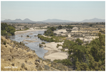
The Mojave River
Playas
Sand Dunes
Human Impacts
References
-.-
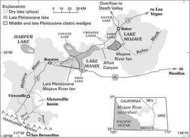
The Mojave River and Associated Lakes
The Mojave River is the largest drainage system in the Mojave Desert. It's modern extent and capacity is only a fraction compared to its extent during the Last Glacial Maximum. At its peak during this last ice age, the Mojave River drainage basin extended from the San Bernardino Mountains in the west; it flowed east and north ultimately merging with the Amargosa River before draining into Lake Manly in Death Valley. At this peak period, waters of the Mojave River drainage system flowed through, or contributed water to, several great Pleistocene Lakes: Lake Manix (which incorporated modern dry lake basins Afton, Troy, Coyote, Harper, and Cronese basins), and Lake Mojave (including dry Soda Lake and dry Silver Lake basins)(see the map on the Changing Climates & Ancient Lakes page). Today Soda Lake is the current terminal point of the Mojave River (although it has flowed into Silver Lake in historic times).
This drainage system evolved along with the changing landscape beginning in late Tertiary time when concurrent tectonic uplift of mountain ranges around the Mojave region and changes in regional climatic conditions were occurring. The modern river system began developing as westward-flowing stream drainages were blocked by the uplift of the Transverse Ranges along the greater San Andreas Fault System. The combination of blocked drainage systems and increased precipitation with the onset of cooler or ice age conditions at the close of the Tertiary resulted in the filling of basins with water (and sediments). Progressively through the latest Tertiary and into the Quaternary periods, lakes filled and stream overflowed through low divides between ranges and flooded adjacent basins. In this manner, the Mojave River evolved from the spilling over of lakes in the western Mojave Desert region. These large lakes do not exist today. Two large lakes that played perhaps a most significant role in the development of the landscape in the Mojave National Preserve area were Lake Manix and Lake Mojave. Sediments associated with these ancient lake deposits (and others in the region) record a story of climate change in the region.
Lake Manix was a large inland lake that was located in the Barstow, CA region (dry Troy Lake and Coyote Lake are remnants of this larger lake basin), and Mojave Lake in the Baker, CA region (dry Silver Lake and Soda Lake are remnants of this ancient lake basin). The development of these lakes and other lakes in the region was progressive with time, with Manix Lake filling first, and Mojave Lake forming later when the Lake Manix filled to capacity and spilled westward, ultimately carving Afton Canyon during the last glacial maximum about 18,000 years ago (Jefferson, 2003).
Debate remains whether earlier in the Quaternary the greater Mojave River drainage system (including Lake Manley and the Owens River drainage) filled to overflowing capacity and spilled into the Bristol Lake basin (south of the Mojave National Preserve), or possibly to the Colorado River (Enzel et al., 2003, Cox et al., 2003; Anderson & Wells, 2003). No water from the Mojave River system flows into the Bristol Lake basin at present or in the recent past. And in general, groundwater drainage systems follow patterns in surficial flow, but whether groundwater originating from the Mojave River basin ever makes it to the Colorado River is not resolved.
The synchronicity of lake formation with cooler and wetter climatic conditions in the Mojave region's past has been the target of abundant research from many angles and for many decades. Developing an understanding of climatic cycles (wet to dry) is fundamental to resolving changing landscape conditions (including plant cover, soil development, erosion, alluvial fan processes, playas and lakes, etc.); and understanding the relationships between these different variable elements. For instance, Soda Lake is now essentially a dry lake basin (a playa), of which only temporary flooding occurs on roughly a decade basis. Currently, the Soda Lake basin is fed by groundwater flow and episodic stream discharge from the surrounding mountain ranges and high-flow discharge from the Mojave River. Enzel et al. (2003) suggests that the average annual flow of the lower reaches of the Mojave River would have to be nearly a magnitude larger than the river's average current annual flow of 9,500,000 cubic meters. This 10-times volume would be necessary, along with reduced evaporative conditions, to maintain a lake consistent with the last glacial maximum. This means that rainfall amounts would probably need to be several times greater than current regional averages, and seasonal cooling and humidity would need to be significantly greater and last longer to overcompensate for evaporation effects. Currently, evaporative potential in the basin regions exceeds stream and groundwater flow input, and hence, today no lakes exist and desert conditions prevail.
The linkage of climatic changes with surface processes is only partly understood. There is undetermined lag between when cool and wet conditions start and when lakes can form and fill to their capacity. Also, the timing between the start of cool and wet conditions and the when ecological communities adapt and spread across the region may not not be synchronous. The reverse is true for changes from wet to dry conditions. Regional lake deposits show drying occurred about 9,000 years ago as sedimentary records transition from lake deposits, to intermediate marshland conditions, and to dry and desiccated playa conditions. The change from wet to dry conditions had a major impact on the ecology of the Mojave region (the vegetative cover and the animal species the landscape supported, including humans). Plant communities that were probably prevalent throughout the lower landscape regions are now restricted to the highest and wettest mountain areas, and probably many other species existed in the region that were adapted to a completely different seasonal pattern, but do not exist today. Likewise, aquatic or semi-aquatic species (fish, amphibians, turtles, arthropods, etc.) adapted to lake environments are restricted to spring-fed ponds or ephemeral spring fed streams, such as in portions of the Mojave River in Afton Canyon. The distribution of these species across the Mojave region (including in the Colorado River) may require a greater regional drainage system in prehistoric times.
Next > Playas
Mojave River