Introduction
Physiography
Weather Data
Geologic History
Changing Climates
Weathering & Erosion
Carbonate Rocks
Granitic Rocks
Volcanic Rocks
Faults
Pediments
Stream Channels
Stream Terraces
The Mojave River
Playas
Sand Dunes
Human Impacts
References
-.-
Volcanic Rocks and Associated Landforms
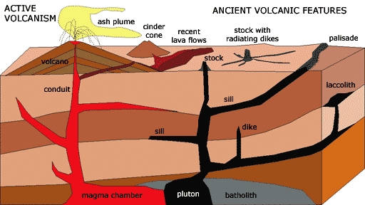
Examples of landform features associated with modern and ancient
volcanism. A volcano forms at an site where erupted material builds
up (including lava flows, cinders, and ash). Over time, weathering
and erosion break down and strip away surficial materials, leaving
behind remnants of volcanic rock that chilled below the surface
(including plutons, dikes, sills, and laccoliths). A pluton is a
deep-seated igneous intrusion. A stock is a remnant of the vent of a
volcano or plutonic body with an areal extent less than 40 square
miles (or 100 square kilometers). Far below the surface, a large
magma chamber will slowly cool to form small plutons and large
batholiths. A dike is a place were molten material cooled in a
vertical crack. Sills form when molten material squeezes between
horizontal layers. An escarpment that forms when erosion exposes a
sill is call a palisade. A laccolith is a blister-shaped intrusion.
Evidence of past volcanism can be seen throughout the Mojave Desert region. Within the Mojave National Preserve, two notable areas that display volcanic rocks and associated landforms include the Cinder Cones and Lava Flows National Natural Landmark Area (which encompasses many Quaternary-age volcanoes) and the Hole-in-the-Wall area (a more ancient volcanic area). Other areas of extensive volcanic rocks are the Piute Range and Pinto Mountain.
Cinder Cones and Lava Flows National Natural Landmark Area
Volcanic eruptions have occurred many times throughout the Mojave National Preserve in the geologic past; the most recent eruption in the region was about 8,000 years ago. Many of the youngest volcanic features in the Cinder Cones and Lava Flows area have changed very little since lava last erupted. Plants communities have not yet become established on younger cinder cones and lava flows. Recent volcanic cones and lava flows are easy to recognize. The cooled black lava rock is called basalt. In many places, the surface of these flows still preserves the fluid texture created by flowing lava. Blocks and pieces of frothy lava rock (called cinders) piled up around places where molten material reached the surface, producing cinder cones.
The Hole-in-the-Wall Volcanic Area
Evidence of older volcanic eruptions is found throughout the Preserve.
Massive eruptions, larger than perhaps any eruption recorded in historic
times, occurred in the vicinity of Hole-in-the-Wall. Geologists have
determined that massive eruptions began in that region around 18.5 million
years ago, and continued for several million years. Massive
explosive-style eruption blanketed the region with molten or near molten
debris. In places where these rocks are still preserved, individual beds
(consisting mostly of rhyolite tuff) approach several hundred feet
in thickness. Rhyolite is a volcanic rock that has a mineral
composition similar to granite, but most crystal grains are too small to
see. Tuff is a textural name for a volcanic rock formed from an
agglomeration of volcanic particles or rock fragments that may be tightly
cemented or "welded" (due to heat from the eruption). Clouds of volcanic
ash from these eruptions probably blanketed the entire Great Basin region
and beyond. With time, however, most of the volcanic material ejected from
these eruptions has long since eroded away.
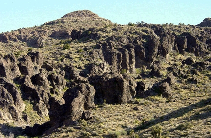
Weathering and erosion of tuff forms hoodoos
(irregularly-shaped rock spires) along Wild Horse Canyon near
Hole-In-The-Wall.
In the past, massive explosive volcanic eruptions (called ignimbrites)
produced thick blankets of volcanic tuff that covered large portions of
the Mojave region. In places these ignimbrite deposits and other more
fluid lava flows mantle topography, preserving past landforms. A pediment
is preserved at Cinder Cones, and ancient hills and pediments are
preserved near Hole-In-The-Wall. Ignimbrite deposits are dense and tend to
resist weathering and erosion. As a result, they tend to focus stream flow
around them, forming narrow channelized canyons. This can be seen in
drainages from the New York Mountains through Lanfair Valley to Fenner
Valley. This channel development pattern can also be seen along lava flows
in the Cinder Cones area. Dry water falls occur where streams drain coming
off the volcanic flows into the more easily eroded alluvial sediments
surrounding the volcanic field.
In contrast, cinder cones degrade relative quickly compared to the lava
flows. In a study of erosion rates of volcanic materials in the Cinder
Cones region, Dohrenwend and others (1984) found that the oldest remains
of cones were only about 1 million years old, whereas the older flows were
about 3 million, and the remains of stock edifices were as old as 7
million years.
Next > Faults & Active Tectonics
Also see:
Cinder Cones National Natural Landmark
Hole-in-the-Wall
Lava Tube
Lava Formations
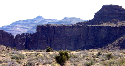
View looking north toward the volcanic rocks (consisting of ash beds and lava flows) of Hole-In-The-Wall (left foreground) and Table Top Mountain (distance).
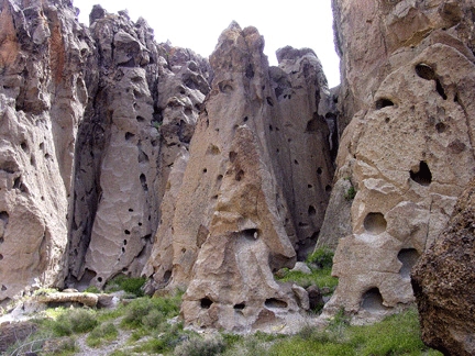
Tafoni is a type of surface weathering caused by wetting and drying of porous rocks that gives these cliffs of rhyolite tuff a "cheese-like" appearance (located in the canyon below the campground at Hole-In-The-Wall).
-
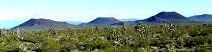
These three cinder cones are in the Cinder Cones and Lava Beds area. Eruptions in this volcanic field occurred over the last several million years. Successive eruptions and flows have blanketed older flows. In some cases, lava flowed on the surface for as much as 10 kilometers from the eruption site.
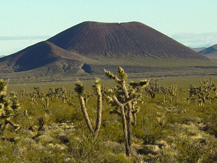
A nearly perfect cinder cone in the Cinder Cones and Lava Beds Natural Landmark Area in the north-central portion of the Mojave National Preserve. Notice rills and gullies that are slowly degrading the cone.
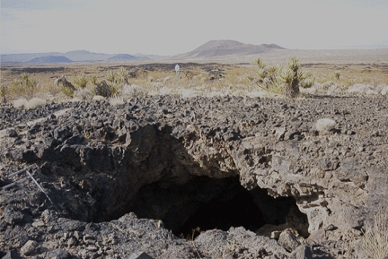
A lava tube forms where the surface of a lava flow cools, but lava continues to flow below the surface. In this example in the Cinder Cones and Lava Beds area, the surface layers of basalt lava have collapsed, creating an entrance to the lava tube. More cinder cones are in the distance. Note the rubbly, rough lava flow surface.
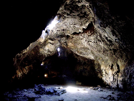
View of the inside of a lava tube in the Mojave National Preserve. Natural skylight shines on the dust-covered floor and provided reflected light throughout the short passage of this lava tube.