Introduction
Physiography
Weather Data
Geologic History
Changing Climates
Weathering & Erosion
Carbonate Rocks
Granitic Rocks
Volcanic Rocks
Faults
Pediments
Stream Channels
Stream Terraces
The Mojave River
Playas
Sand Dunes
Human Impacts
References
-.-
Stream Channel Development
in the Changing Mojave Climate
Progressive landscape development in any particular area is a function
of many factors including climate (precipitation and seasonal weather
patterns), vegetation, slope and drainage topography, bedrock character,
tectonic history, and possibly other factors. Interpreting the history of
a landscape (or modeling its future) is difficult without a measure of
these different variables, and their changes through time. However, as our
collective knowledge of past climatic conditions and geologic history of
the Mojave region progresses, patterns in observation begin to emerge that
can be modeled. Below is a geomorphic model of stream channel development
for roughly the past million years for the Mojave region (but can be
applied elsewhere). The diagram illustrates an idealized cross section of
an alluvial surface where the progression of stream down cutting and
infilling resulted in the development of channels and terraces (incised
flood plains); youngest to oldest from left to right. The model
incorporates observations from the field with knowledge gained from
climate history investigations in the region.
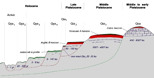
This geomorphic profile shows interpretation of the relative
ages and character of Quaternary alluvial channels and terrace
deposits in the Mojave region (Dave Miller, USGS).
Note that no vertical elevation is applied. Typically the greatest
elevation differences between active channels and older terrace
deposit occur high on an alluvial fan and may range measurably by
tens of meters. Low on alluvial fan the differences between oldest
and youngest deposits may be less than a meter.
Qya1 - "Quaternary young alluvium" (Qya); the "Qya1" represents
an active stream channel and its deposits; the channels tend to be void of
vegetation and display evidence of recent stream flow activity.
Qya2 - represents older flood plain surfaces that have not
been disturbed by flooding long enough for plants to become
established.Qya2 surfaces typically have the greatest biomass of all
surfaces. This is probably a combination factors: roots can take advantage
of the loosely consolidated deposits and access to moisture at depth. As
roots stabilize the Qya2 surface flood overbank fines can allow for
increased moisture retention.
Qya3 & Qya4 - represents mid- to older-Holocene alluvial
fan surficial deposits that are elevated and isolated from active channel
erosion. These surfaces have a thin, intermittent soil, often with
accumulation of floodplain overbank deposits and wind-blown silt deposits
on surfaces that have not experienced significant erosion. These surface
are generally sparsely vegetated relative to Qya2 surfaces.
Qia1, Qai2, & Qia3 - represent progressively-older, late
Pleistocene age deposits and surfaces that range in age from about 20,000
to 400,000 years. These deposits and surfaces possibly correspond to
cycles of aggradation and erosion in conjunction with alternating wet and
dry climatic cycles in the Mojave region during the late Pleistocene.
Older surfaces of Qia type tend to be barren of plants relative to the
younger Qya surfaces, and may have well-developed desert pavement that may
cap a thin silty, loam soil (vesicular A horizon) that overlies a more
weathered, dense clay-rich subsoil (Argillic B horizon). Qai1 to Qai3
surfaces tend to be best preserved in the middle portion of "stable or
well-developed" alluvial fans, or occur as elevated bench-like terraces
along stream channels with broad valleys.
Qoa - represents middle Pleistocene and channel deposits and
terraces that are roughly older than 400,000 years. These deposits are
typically highly eroded, and are locally represented at rounded hills
consisting of tightly cemented (caliche) alluvial gravels or
paleosols (ancient soils horizons), typically along the range front
of mountains. In Qoa deposits, the sediment's cement is dominantly calcium
carbonate precipitated from meteoric (atmospheric water) and groundwater
in the past, but the process is ongoing. In desert conditions, infrequent
rains dissolve calcium carbonate from the upper soil, and carries
dissolved components downward. The accumulation of calcium carbonate
through plant transpiration processes creates an impenetrable
caliche (calcic horizon) in the lower subsoil. In some places, the
calcium carbonate and other mineral precipitates may have been contributed
by migrating groundwater. Older Pleistocene and late Tertiary deposits
have long since been eroded away in the Mojave region, or are locally
incorporated in older basin-fill deposits; there is generally no surface
expression remaining for these older deposits/features.
Stream Channel Processes
Even in the mountainous regions most streams flow only during or
shortly after storms. Perennial water only flows in groundwater discharge
areas associated with springs in a few mountain canyons, in Afton Canyon
where the regional groundwater table intersects the canyon bottom, and a
few other springs. In most areas within the Mojave region, streams will
flow only after long periods of steady rain, typically during a wet
winter. The periodicity and intensity of such rain events depends on
elevation, but in the lower regions historically floods may only happen in
intervals measured in several years to decades.
Floods produce the visually definable channels in streambeds (active
channels). When water is not flowing in the stream between storm
events, an active channel typically consists of sand, gravel, dried mud,
or barren bedrock. Cut and fill sediment bedforms appear relatively fresh
(where not trampled by animals, including humans). Flowing water strips
away vegetation, moves sediment, and reconfigures bedforms in the channel.
Sediment character and supply, slope, and flow volume and duration are
controlling factors that defines the size of stream channels and the
character of sediment found in the barren channel once a flood event is
over. In canyons above the mountain front, stream channels are typically
filled with angular rock fragments ranging from coarse sand to great
boulders, with rapids or falls occurring where bedrock is exposed in the
stream channel. Larger floods can scour the channel clear of sediments,
whereas lesser flood events can contribute to the backfilling of channels.
Backfilling is most evident to desert travelers who frequently travel the
same stream beds year after year. In one year a stream bed in mountainous
area may be easily passable by vehicle, but the next year the wash is
inaccessible because finer materials between larger boulders may have
vanished due to an erosion event. Later, the fine deposits between boulder
may reaccumulate after a different storm event. These changes reflect the
differences in duration, spatial patterns, and intensity of individual
storm events affecting a drainage basin.
Downstream of a mountain front streams deposit sediments on alluvial
fans, and in in the more upland areas, the channels on the upper alluvial
fan may go through periods of down cutting, infilling, and channel
migration. Typically the size and depth of the channel, and the size of
the rock fragments diminish in size down slope and away from the mountain
front. In the mid to lower fan area, stream channels typically diminish to
depths less than a meter, and sediment consists of fine gravel and sand.
In most areas, a trunk stream defines the main drainage between coalescing
alluvial fans, or playas (dry lake beds) may exist were topographic
barriers impede the flow of surface water from a drainage basin.
Examples of Stream Channel Features
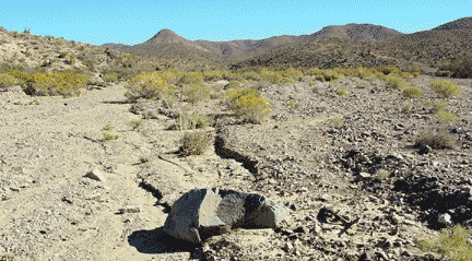
This image shows is a view of an upper fan area in the western
Providence Mountains. The "active channel" on the left (Qya1), and
another less active, higher channel on the right that only receives
water during the most intense flooding events (Qya2). Mature, or
well-established, vegetation populates parts of the flood plain that
generally does not receive flash flood waters (Qya3 and Qya4). The
yellowish plant is cheesebush, a plant adapted to rapid colonization
of disturbed surfaces and common in washes.
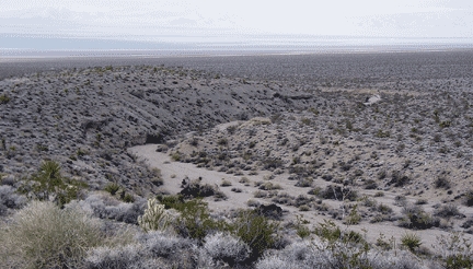
This view looking west from the mountain front of the Providence
Mountains looking down a wash that has incised into older
(Pleistocene) alluvial fan deposits. The wash continues down slope
and eventually merges with the actively aggrading surface of the
lower fan closer to the axial trunk stream (Kelso Wash) that drains
the fan aprons draining from the Providence Range and the Kelso
Mountains. Note the diverse plant community on the high surface in
the foreground.

Cedar Wash is the main channel draining the northern Providence
Mountains region. The break in slope along the Holocene stream
valley is marked by a vegetation change between the Joshua-tree
forest on the slopes, and the desert scrub-covered sandy gravel of
the flood plain. The barren active channels on the modern flood
plain stand out as tan lines. Down cutting by Cedar Wash into older
Quaternary alluvial fan deposits has created a well-developed
terrace along the valley. This down cutting probably occurred during
the wetter regional conditions associated with the last glaciation
period that ended roughly 15,000 years ago. With the dry conditions
that exist today, the valley is gradually filling in with alluvium
because the stream can no longer move sediments faster than they
accumulate.
Next > Stream Terraces and Older Surfaces