Introduction
Physiography
Weather Data
Geologic History
Changing Climates
Weathering & Erosion
Carbonate Rocks
Granitic Rocks
Volcanic Rocks
Faults
Pediments
Stream Channels
Stream Terraces
The Mojave River
Playas
Sand Dunes
Human Impacts
References
-.-
Playas
A playa is a dry, vegetation-free, flat area at the lowest part of an undrained desert basin. It is a location where ephemeral lakes form during wet periods, and is underlain by stratified clay, silt, and sand, and commonly, soluble salts. Playas occur in intermountain basins throughout the arid southwestern United States. Although playas may appear as featureless plains, they are rich in features and characteristics that can reveal information about climates, past and present. Many playas in the Mojave region were the location of lakes and marshes during the last glacial period. These perennial water bodies completely dried up about 8,000 years ago. Today they flood only after seasonal storms provide flashflood waters, or in some cases, springs discharge large quantities of groundwater onto the playa.
Sediments are distributed across the surface of a playa by thin sheets of water that flow down slope (relief on playas may be measurable in only centimeters per mile), or by sediment entrained in standing water and redistributed by wave action. Most years playas are dry, or water may only cover the lowest portion of the playa or near water sources, such as near springs or where ephemeral streams discharge onto the playa surface. Between wet periods the surface of the playa typically completely dries out and may even become desiccated, forming polygonal cracks and fissures as clay-rich sediments dry out. The mud-cracked, desiccated sediments on the playa can be a primary source of dust during windstorms. Many playas in the desert southwest display giant polygonal fissures attributed to the drying out of sediments at depth; these fissures are attributed to both the ongoing climatic drying of the region and to extraction of groundwater (Neal & Motts, 1967). Playa surfaces are quite dynamic environments with surface channels, playa margins, sedimentary materials, and biota changing with each flooding event.
On playas where the groundwater table is at or near the surface, soluble salts will precipitate, forming ephemeral crusts that may or may not survive subsequent wetting episodes. The high salt and clay content of playa surface mud, and the dry and hot conditions that prevail most of the year, prevent plants from becoming established. However, the surface of a playa may not be completely homogeneous. Sand may accumulate in channels, fill in desiccation fissures, or accumulate around spring mounds; these areas may allow plant communities to become established.
Playas typically form in closed basins or where drainages may be blocked by faulting, lava flows, or buildup of alluvial fans. Their location within a basin may provide evidence whether the basin is tectonically active. For instance, the playa in southern Death Valley is located immediately adjacent to rising Black Mountains (to the east) where the valley is rapidly sinking; whereas on the opposite side of the playa huge alluvial fans drain from the Panamint Mountains (to the west). The assymetry of the valley, mountains, and playa are all dictated by active faults. In addition, coalescing alluvial fans may create catchments that result in the formation of small playas.
Although there are numerous playas in the region, the Mojave National
preserve only has two significant playas, much of the dry Soda Lake
and
part of Ivanpah dry lake (see the aerial photograph on the Physiography
page). During the Last Glacial Maximum the low divide between Soda Lake
and Silver Lake to the north was flooded (a human modified channel now
exists between the two lake beds), and an ancient beach ridge locally
occurs 40 feet above the north end of the Silver Lake playa. At this
elevation, the divide between Soda Lake and Cronese basin (with its two
playas, West Cronese Lake and East Cronese Lake) would have been flooded.
This expanded lake system is known as ancient Lake Mojave. The surface of
Silver Lake playa is more than 10 feet lower than the low end of Soda Lake
playa (near Baker). As much as 10 feet of water has been reported on
Silver Lake playa at irregular intervals (Thompson, 1929).
Soda Lake is the largest playa in the park, being about 60 square miles. The two images below taken in the vicinity of one of several springs along the west side (near Zzyzx) illustrate the transition from wet to dry conditions on the playa. The existence of the spring demonstrates the groundwater table is at or near the surface along the west side of the playa (an attempt to walk on the wet playa surface will result in a very muddy experience). During dry periods, alkali salts, primarily sodium carbonate and sodium bicarbonate, form a frothy-white coating on the surface throughout the south and southwest portion of the playa. Salt crusts do not form at the north end of the playa (or on Silver Lake) probably because the groundwater table is more than 20 feet below the surface, and increase in depth northward into the Silver Lake valley (Thompson, 1929). The salts accumulate through capillary rise of salty groundwater and evaporation. These salts return to the groundwater when it rains.
These salts contribute much to the wind-blown dust and haze in the Mojave region late in the summer and fall. Sediment provided by the discharge of the Mojave River into the Soda Lake basin is the source of much of the clay, silt, and sand in the playa sediments. The sand from the Mojave River is the primary source of eolian sand for Kelso Dunes and Devils Playground.
Next > Sand Dunes & Dust
source - NPS
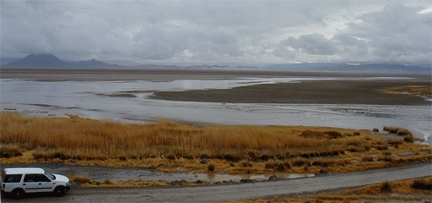 Winter storm precipitation results in increased water
discharge onto Soda Lake from one of several
springs
near
Zzyzx,
CA
Winter storm precipitation results in increased water
discharge onto Soda Lake from one of several
springs
near
Zzyzx,
CA(photo by Dave Bedford, February, 2001).
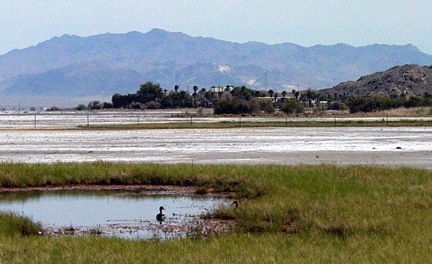
This view of the springs area near Zzyzx shows that by late spring the flaky soda crust deposts have redeveloped on the surface of Soda Dry Lake (photo taken in May, 2003).