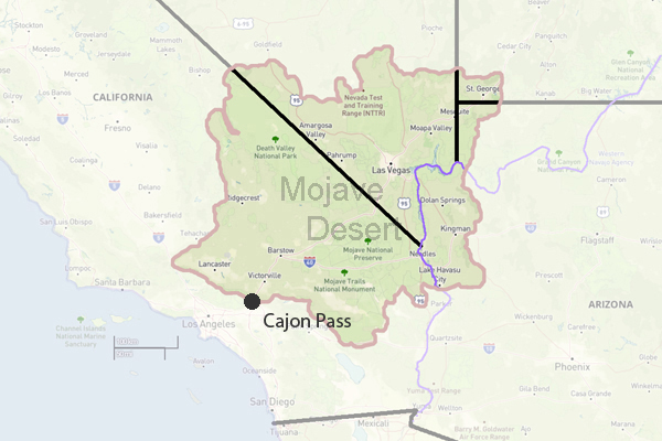
Cajon Pass
Cajon Pass is the classic gateway between the Mojave Desert and the coastal plain of Southern Californiaa place where geology, water, and necessity have funneled people and commerce for centuries.
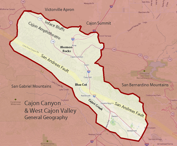
The pass follows a break in the mountains shaped by the San Andreas Fault, with creeks, springs, and sheltered benches that supported Native travel and habitation long before Mexican-era land grants such as Rancho Muscupiabe marked early settlement at the passs western mouth. In the 19th century, Mormon pioneers, freight teams, stage lines, and toll roads worked the grades and canyons, and in the 1880s the California Southern Railroad established the pass as a modern transportation throat.
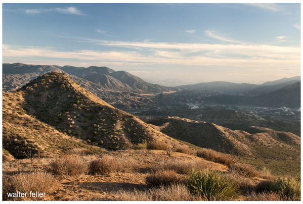
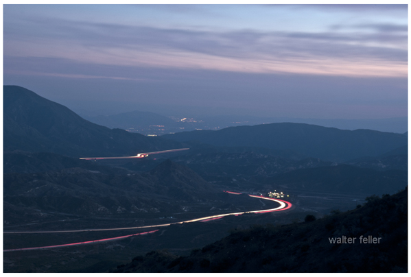
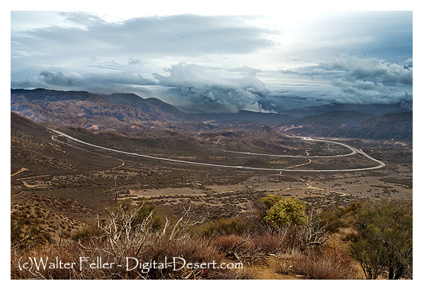
The automobile age followed quicklyfirst with named auto trails such as the National Old Trails Road and the Arrowhead Highway (US 91), then with Route 66, which turned Cajon into a famous passage for dust-era migrants, vacationers, and postwar motorists. Today, Interstate 15, multiple rail lines, and long-distance foot travel on the Pacific Crest Trail continue that corridor logic. Alongside the transportation story, Cajon Pass offers striking fault-driven landforms and landmarksMormon Rocks, Blue Cut, Cajon Creek, and sag ponds such as Lost Lakeplus cultural sites that preserve the older layers of movement, settlement, and connection.
Hiking & Interpretive Areas
- Mormon Rocks Interpretive Trail: Trail showcasing dramatic sandstone formations and local history.- Pacific Crest Trail: National scenic trail that crosses Cajon Pass on its way from Mexico to Canada.
- Crowder Canyon: Historic wagon route and hiking trail through a narrow canyon of the pass.
A Brief History
Cajon Pass timeline
Pre-contact to 1700s A long-used Indigenous corridor organized by water, shelter, and workable grades Cajon Creek drainage and riparian pockets still explain where natural travel wants to go.April 29, 1843 Mexican-era land tenure formalized at the mouth of the pass when Governor Manuel Micheltorena grants Rancho Muscupiabe to Michael C. White (Miguel Blanco) the ranchos documented setting is tied to the western approach and the Devil/Cable canyon area context.
1850s (commemorated 1851 crossing) Mormon-era movement becomes part of the passs settlement memory and later civic commemoration the Crowder Canyon/monument tradition anchors this layer in public memory.
Midlate 1800s Freight, stages, ridge-and-canyon routing, and toll-road logic intensify (maintenance becomes a business) older grades and hogback/ridge place-names are the main on-the-ground traces (best handled as mapped alignments on your subpages).
Nov. 9, 1885 Rail breakthrough: California Southern Railroad completes the route through Cajon Pass (the corridor becomes an engineered rail throat) the passs rail geometry still defines how people read Summit and the big curves.
19131914 Auto-trail era: National Old Trails Road is operating as a signed/promoted motor route through Cajon the motor corridor begins to standardize the pass as a through-route, not just a local grade.
1919 Camp Cajon opens (William Bristols welcome/rest stop model) commemorative/restored elements and the site logic near the highway remain the physical anchor of this episode.
1926 Route 66 designation (numbered federal highway era through Cajon) Route 66 fragments, frontage segments, and junction-place identities carry the layer.
1930 Major Route 66 engineering in the northern pass (large cuts and realignment) cut landscapes and abandoned benches beside newer grades read as pavement archaeology.
March 1938 Great Flood destroys Camp Cajon and reshapes parts of the corridor; Camp Cajon is not rebuilt flood-scarred channel logic and the not rebuilt decision are the interpretive takeaway.
1950 Route 66 widened to four lanes (two each direction) divided-highway remnants and later-paralleled alignments are the trace.
19521955 Further four-lane/divided improvements across the pass (mapped second lanes era) the two-stage widening can be shown as a map overlay (excellent for your Route 66 1953 subpage).
History & Settlements
Cajon Passs history and settlement story follows a gateway that people repeatedly reused and then formalized. Native travel and camps clustered where Cajon Creek offered water and shelter. In the Mexican era, land tenure shaped the western approach, with Rancho Muscupiabe marking early settlement. The American period added freight, stage lines, Mormon-era routes, and toll roads. Service nodes grew at junctions and summitsDevore, Keenbrook, Cajon Junction, and Cajon Summit. Rail in the 1880s and Route 66 later intensified roadside communities and amenities like Camp Cajon.- Rancho Muscupiabe: Historic Mexican land grant and early settlement site at the base of Cajon Pass.
- Devore/Keenbrook Alice Hall: Early communities near Cajon Pass with roots in local development and hospitality.
- Cajon Junction, CA: A roadside stop and service area at the confluence of key roads through the pass.
- Cozy Dell: A lesser-known canyon or area near Cajon Pass with a history tied to early travelers.
- Oakdale Nudist Camp: A mid-20th century nudist resort once located near Cajon Pass.
- Cajon Summit: A small settlement at the top of Cajon Pass, historically a key point for travelers.
- Posts at San Bernardino: Military or settler outposts that supported early development through the region.
- Camp Cajon: A roadside rest stop and picnic area created in the 1920s to welcome travelers to Southern California.
- Glen Helen: A regional park and historical ranch area near the mouth of Cajon Pass, known for its natural amphitheater, rodeo grounds, and roots in early settlement history.
Natural & Physical Resources
Cajon Pass works as a corridor because water, terrain, and fault-shaped landforms concentrate movement into a few usable routes. Seasonal Cajon Creek and shaded riparian pockets provided camps, stock water, and natural grades, while floods periodically reworked crossings and roadbeds. The San Andreas Fault controls the passs low gap and creates features like sag ponds (Lost Lake) and linear valleys. Geology underlies landmarks such as Mormon Rocks and Blue Cut, and the chaparral-to-desert ecotone supports varied plants and wildlife.- Heritage Resources: Cultural and historical features preserved in the Cajon Pass region.
- Physical Resources: Natural features such as water, minerals, and terrain vital to the pass.
- Plants & Wildlife: Native species found throughout Cajon Pass, including chaparral and riparian habitats.
- San Andreas Fault: Major fault line running through Cajon Pass, influencing its topography and seismic activity.
- Cajon Pass Geology: Specific details about the formations and movements in the pass area.
- Cajon Creek: A seasonal stream draining the pass, important to early settlements.
- Lost Lake: A sag pond formed along the San Andreas Fault, often holding water year-round.
- Sycamore Grove: A shaded area with native sycamore trees, possibly used as a campsite or picnic area.
- Lone Pine Canyon: A side canyon on the eastern slope of the pass, often used as a backcountry route.
Trails, Roads & Highways
Cajon Passs roads and trails form a layered stack of alignments, each responding to the same hard facts: grade, water, and narrow points in the terrain. Early routes favored practical passages such as Sanford Pass and ridge-and-canyon lines remembered in names like Mormon Hogback, then toll roads formalized maintenance and control where travel was profitable. In the auto era, the National Old Trails Road and the Arrowhead Highway (US 91) established marked motor routes, soon followed by Route 66 with improved curves and surfaces. State Route 138 became a key cross-connection, while Interstate 15 ultimately replaced and overrode many older roadbeds, leaving fragments, frontage roads, and traceable grades as the visible archaeology of earlier travel.- Sanford Pass: Historic route over the ridge of the Cajon Pass.
- Mormon Hogback: A narrow ridge road used by Mormon settlers in the 19th century.
- Toll Road: Privately constructed road through Cajon Pass, charging travelers in the 1800s.
- Toll Road through the Pass: The specific route used for toll collection in early transportation.
- National Old Trails Road: Early transcontinental auto route through Cajon Pass.
- Interstate 15 Freeway: Modern highway built through the pass, replacing older roads.
- State Highway 138: East-west route intersecting I-15 through Cajon Pass.
- Arrowhead Highway (US 91): Historic auto trail that predated Route 66 in the area.
Route 66 Map: Mapping of the famous highway as it passed through the region.
-
Route 66 - 1953
: A look at the alignment of Route 66 in the early 1950s through Cajon Pass.Railroads & Rail History
Cajon Pass Railroad History
Cajon Pass is one of Southern Californias great railroad choke points: a steep, engineered climb where grades, curves, and added tracks reveal how seriously carriers have treated the corridor. The breakthrough era begins with the California Southern Railroad in the 1880s, proving a rail route could reliably cross the pass and link coastal markets to inland and desert lines. Over time, the pass evolved into a multi-line, high-capacity freight artery, with signature locationsSummit, Sullivans Curve, and Hill 582defined as much by track geometry and elevation as by settlement.California Southern Railroad: The original railroad line built through the pass in the 1880s.
- Railroads: General reference to the many lines and upgrades made through Cajon Pass.
- Cajon Summit: High point for road traffic;
- Summit, CA.: High point for rail and road traffic; a key spot for railfanning and history.
- Hill 582: A popular railfan site with a scenic overlook and historic importance.
- Sullivan's Curve: A wide, photogenic bend in the rail line named after photographer Charles H. Sullivan. Famous for panoramic views of freight trains curving through Cajon Pass.
Geologic Features
- Mormon Rocks: Iconic sandstone formations shaped by wind and water along the San Andreas Fault.- Blue Cut: Narrow passage carved by floodwaters; a historic and scenic spot in Cajon Pass.
- San Andreas Fault