Death Valley National Park
Hottest, Driest, Lowest: Death Valley is a land of extremes. It is one of the hottest places on the surface of the Earth with summer temperatures averaging well over 100 degrees Fahrenheit. Almost universally claimed as the lowest point in the Western Hemisphere, Laguna del Carbon in Argentina is lower, at 344 feet below sea level, Badwater Basin at 282 feet below sea level, is the lowest, driest place in North America with an average rainfall of only 1.96 inches a year.
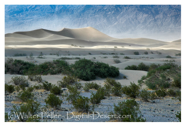
This valley is also a land of subtle beauties: Morning light creeping across the eroded badlands of Zabriskie Point to strike Manly Beacon, the setting sun and lengthening shadows on the Sand Dunes at Stovepipe Wells, and the colors of myriad wildflowers on the golden hills above Harmony Borax on a warm spring day.
Death Valley is a desert valley located in Eastern California within the Mojave Desert. It is the lowest, driest, and hottest region in North America. Spanning approximately 3,000 square miles, Death Valley is known for its extreme temperatures and unique geological features.
The Amargosa Range borders the valley to the east and the Panamint Range to the west. It reaches its lowest point at Badwater Basin, which sits at an elevation of 282 feet below sea level. This makes it the lowest point in both the United States and the Western Hemisphere.
Death Valley's harsh climate and arid conditions make it a challenging environment for most forms of life. However, a surprising variety of plants and animals have adapted to survive in this extreme desert environment. Some of the notable plant species include desert holly, desert gold, and various species of cacti. Wildlife in the area includes desert bighorn sheep, kit foxes, and coyotes.
One of the most famous attractions in Death Valley is the Mesquite Flat Sand Dunes. These towering sand dunes, formed by windblown sand, create a stunning landscape that attracts photographers and visitors from around the world. Another popular destination is Zabriskie Point, which offers panoramic views of the rugged badlands and colorful rock formations.
Death Valley is also home to unique geological features such as the Racetrack Playa. This dry lakebed is known for its mysterious moving rocks, which leave long trails behind them as they seemingly glide across the surface. The exact cause of this phenomenon is still debated among scientists.
Visitors to Death Valley can explore the park's numerous hiking trails, take scenic drives through the valley, and camp under the star-filled desert sky. However, it is important to be prepared when visiting this extreme environment. The temperatures in Death Valley can reach well over 100 degrees Fahrenheit in the summer, and the lack of water sources makes it crucial to bring an ample supply of water.
In conclusion, Death Valley is a unique and awe-inspiring destination showcasing nature's power and beauty. Despite its harsh conditions, it is a place of remarkable geological features and is home to a surprising array of plant and animal life. Whether you are a nature enthusiast, a photographer, or simply seeking an adventure, Death Valley offers an unforgettable experience in one of the most extreme environments on Earth.
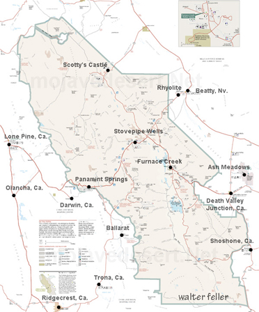 Death Valley Map Page