Death Valley Points of Interest
The northern structural basin of the Mojave system and the lowest place in North America. Death Valley contains the great terminal basin of the regional drainage network and preserves vast salt flats, dune systems, volcanic craters, and mountain ranges.The Death Valley National Park has many interesting places to visit. It offers scenic views, historical locations, and natural wonders. A list of some of these amazing spots is as follows:
Death Valley National Park forms the northern structural basin of the Mojave Desert system and contains the lowest place in North America. The valley serves as the great terminal basin of a large regional drainage network and preserves a wide range of desert landscapes, including vast salt flats, dune systems, volcanic features, canyon systems, and steep mountain ranges rising from the valley floor. The park contains many places of interest, from scenic viewpoints and geological formations to historic sites connected with mining and early desert travel. Because of its great size, the park is often best understood by region. Each major area offers a different view of Death Valley's geography and history. Points of Interest by Area
Furnace Creek
Furnace Creek is the primary visitor center area of Death Valley National Park and the most developed part of the valley. The area includes visitor services, historic sites, and access to some of the park's best-known locations such as Badwater Basin, Zabriskie Point, Dante's View, Artists Drive, and Golden Canyon. Furnace Creek also serves as a convenient base for exploring the central valley.Panamint Valley
Stovepipe Wells lies along the central valley floor and provides access to some of the park's most recognizable desert landscapes. The area is best known for the Mesquite Flat Sand Dunes, where wind-driven sand has formed large dune fields at the base of the Grapevine Mountains. Nearby Mosaic Canyon and the wide views across the valley floor make this area a popular stop.Scotty's Castle
Located in the northern part of the park in Grapevine Canyon, Scotty's Castle is one of the most famous historic sites in Death Valley. The Spanish-style mansion was built in the 1920s and became associated with the colorful desert character Walter Scott, known as "Death Valley Scotty." The surrounding canyon landscape also contains springs and rugged desert scenery.Panamint Springs
Panamint Springs sits along the western edge of Death Valley near the base of the Panamint Range. This small desert settlement provides access to remote canyons, high mountain viewpoints, and routes leading into the western mountains of the park. The area offers dramatic views across Panamint Valley and toward the rugged peaks of the Panamint Range.Panamint Valley
Panamint Valley lies west of Death Valley and forms another large desert basin separated from the main valley by the Panamint Range. The valley is known for its expansive desert floor, large alluvial fans, and towering mountain walls. Historically, this area was crossed by early travelers, miners, and desert freight routes moving through the region.Saline Valley
Saline Valley is a remote desert basin north of Panamint Valley and surrounded by high mountain ranges. It is one of the most isolated parts of the Death Valley region and is known for its desert scenery, dry lake beds, and natural warm springs. Because of its isolation and rugged access roads, Saline Valley remains one of the least visited but most distinctive landscapes associated with the park.Together these areas show the variety of environments that make up Death Valley National Park. From the developed oasis of Furnace Creek to the remote basins and mountain valleys beyond the central floor, the park preserves a remarkable range of desert landscapes and historical sites.
Photos and virtual tours of points of interest throughout Death Valley and in close proximity to the national park.
Aguereberry Camp
Aguereberry Point
Artists Palette
Ashford Mill
Badwater
Ballarat
Chloride City
Dante's View
Darwin
Darwin Falls
Devil's Cornfield
Devil's Golf Course
Eagle Borax Works
Eureka Dunes
Eureka Mine
Father Crowley Point
Furnace Creek
Golden Canyon
Greenwater
Harmony Borax Works
Ibex Dunes
Ibex
Inyo Mine
Jubilee Pass
Keane Spring
Keane Wonder Mill
Keane Wonder Mine
Klare Spring
Leadfield
Lippencott
Lost Burro Gold Mine
Mesquite Dunes
Moorehouse Mine
Mormon Point
Mosaic Canyon
Mushroom Rock
Mustard Canyon
Natural Bridge
Needle's Eye
Owl Hole Spring
Panamint Dunes
Racetrack
Rhyolite
Saline Valley
Salt Creek
Salsberry Pass
Saratoga Springs
Scotty's Castle
Shoreline Butte
Shorty's Grave
Shorty's Well
Skidoo Mill
Split Cinder Cone
Striped Butte
Tea Kettle Junction
Titus Canyon
Twenty Mule Team Canyon
Ubehebe Crater
Warm Springs
Wildflowers
Wildrose Kilns
Zabriskie Point
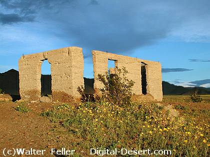
Ashford Mill
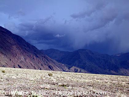
Rainstorm over the Black Mountains
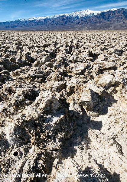
Devil's Golf Course