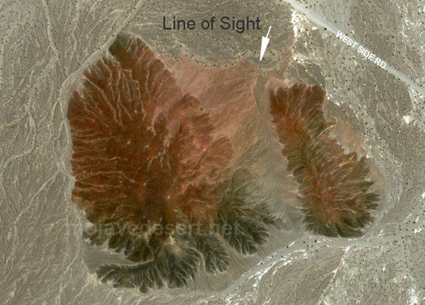
Digital-Desert : Mojave Desert Visit us on Facebook -- Desert Gazette -- Desert Link
Intro:: Nature:: Map:: Points of Interest:: Roads & Trails:: People & History:: Ghosts & Gold:: Communities:: BLOG:: Weather:: :?:: glossary
West Side Road:

Split Cinder Cone

Photo of Split Cinder Cone in south central Death Valley National Park

A small volcanic cinder cone is located near the intersection of Highway 178 and the southern end of the West Side Road. This volcano erupted in the middle Pliestocene along the Southern Death Valley Fault zone (Hildreth, 1976; Spear, 2010). After the eruption, the volcano has gradually split along a strike-slip fault (the western, larger remnant of the cone has moved several hundred feet north relative to the smaller remnant on the east side of the fault). The cone has be right-laterally offset by about 300 feet. (USGS)

satellite image of split cinder cone in Death Valley

Split Cinder Cone Geology

Due to this site’s central location in Death Valley’s south end, this is a good place to view both the Panamint and Black Mountains from a distance and to get a sense of the “pull-apart” tectonic origin of Death Valley itself.

Furnace Creek
Shorty's Well
Shorty's Grave
Eagle Borax Works
Long Camp
Split Cinder Cone
Shoreline Butte
Ashford Mill


Intro:: Nature:: Map:: Points of Interest:: Roads & Trails:: People & History:: Ghosts & Gold:: Communities:: BLOG:: Weather:: :?:: glossary
Country Life Realty
Wrightwood, Ca.
Mountain Hardware
Wrightwood, Ca.
Canyon Cartography
DesertLink
Links to Desert Museums

Grizzly Cafe
Family Dining


Custom Search

AbeBooks
Abraxas Engineering
privacy
These items are historical in scope and are intended for educational purposes only; they are not meant as an aid for travel planning.
Copyright ©Walter Feller. 1995-2023 - All rights reserved.