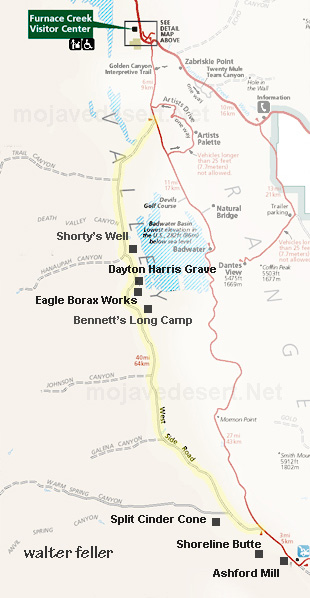
Roads > Westside Road < Death Valley - North Mojave Desert
features - ecology: wildlife - plants - places - region map - map/sat - roads & trails - wilderness - video - aerial - 360 - old west - communities - books - lodging
route 66 - ghost towns - gold mines - parks & ... - joshua tree - death valley - mojave preserve - native culture - history - natural features - geology - glossary - comments


Lake Manly
Water Tank
Bennett's Long Camp
Eagle Borax Works
Shorty's Grave
Shorty's Well
Death Valley Westside Road

A forlorn stretch of dusty dirt road runs at base of the foothills along the westside of Death Valley. The washboard road starts at the southern end of Lake Manly near Ashford Mill, then traces offset north to Furnace Creek. The terrain is flat and featureless, with the exception of several man-made points of interest and a run across the Devil's Golf Course near the end.
--- books about ---
DEATH VALLEY
*** specially selected ***
National Geographic
Death Valley Trail Map
MOJAVE MERCANTILE
DEATH VALLEY VIDEOS
20 Mule Teams - GOLD - Death in the Desert

features - ecology: wildlife - plants - places - region map - map/sat - roads & trails - wilderness - video - aerial - 360 - old west - communities - books - lodging
route 66 - ghost towns - gold mines - parks & ... - joshua tree - death valley - mojave preserve - native culture - history - natural features - geology - glossary - comments
Wrightwood Real Estate
MOUNTAIN HOMES & CABINS
Vacation Rentals & Homes for Sale
Log Cabin Furnishings
Lodgepole Pine Log Furniture
Rustic Decor & Silhouette Metal Art
HighDesertRED.com
High Desert Real Estate Directory
--
Google
Search:
Keywords:
Check out our...
>> RECOMMENDED BOOK LISTS <<
Digital-Desert
Abraxas Engineering
privacy
Copyright ©Walter Feller. All rights reserved.
Respect U.S and international copyright statutes and our right to own and control our work
- DO NOT LINK TO THESE IMAGES FROM WEB PAGES, FORUMS OR BLOGS -
Desert Gazette