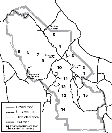
Digital-Desert : Mojave Desert Desert Gazette
True Facts, Legends & Lies
features - ecology: wildlife - plants - places - region map - map/sat - roads & trails - wilderness - video - aerial - 360 - old west - communities - books - lodging
route 66 - ghost towns - gold mines - parks & ... - joshua tree - death valley - mojave preserve - native culture - history - natural features - geology - glossary - comments
Death Valley National Park:

Backcountry Roads


Route #1

Hole-in-the-Wall

    This road traverses east up a gravel wash. After passing through the 400' deep ...

Route #2

Echo Canyon

    The road tends to have deep gravel and is quite rocky 3 miles from the highway. ...

Route #3

Chloride City

    One of the earliest sites of mining in Death Valley ...

Route #4

Titus Canyon

    This popular road is ONE-WAY from east to west. ...

Route #5

Phinney Canyon

    From the pass there are views of the Grapevine Mountains ...

Route #6

The Racetrack

    A dry lakebed famous for its “moving rocks." ...

Route #7

Hunter Mountain and Hidden Valley

    From Teakettle Junction the road becomes rougher. ...

Route #8

Saline Valley

    One of the most remote locations in California, ...

Route #9

Cottonwood and Marble Canyons

    The road drops into the wash and becomes rocky and rough. ...

Route #10

Tucki Mine Road

    After following along the base of the mountains ...

Route #11

Trail Canyon

    This road leads to a spring ...

Route #12

Hanaupah Canyon

    It climbs the huge alluvial fan before ...

Route #13

Johnson Canyon

    Beyond the end of the road a 2 mile hike leads up the canyon to ...

Route #14

Butte Valley via Warm Springs Canyon

    This road follows Warm Springs Canyon past ...

Route #15

Greenwater Valley

    This road follows the length of this ...
Interactive Map


About Backcountry Roads
  • A vehicle with high-clearance will be necessary for all of the roads described, but four wheel-drive may also be required on some of the rougher roads. Inquire at the Furnace Creek Visitor Center or other ranger stations for additional information and current road conditions.

  • Please stay on established roads and respect wilderness closures.

  • Do not remove or disturb any cultural or natural features in the park.

  • Be sure to carry plenty of water; never rely on backcountry water sources.

  • Backcountry camping is restricted to certain areas, please check in at the visitor center before planning an overnight trip and fill out a free Backcountry Camping Permit.

  • Travel and camp using "Leave No Trace" principles.
features - ecology: wildlife - plants - places - region map - map/sat - roads & trails - wilderness - video - aerial - 360 - old west - communities - books - lodging
route 66 - ghost towns - gold mines - parks & ... - joshua tree - death valley - mojave preserve - native culture - history - natural features - geology - glossary - comments
Wrightwood Real Estate
MOUNTAIN HOMES & CABINS
Vacation Rentals & Homes for Sale
Log Cabin Furnishings
Lodgepole Pine Log Furniture
Rustic Decor & Silhouette Metal Art
HighDesertRED.com
High Desert Real Estate Directory
--
Google
Search:
Keywords:
Check out our...
>> RECOMMENDED BOOK LISTS <<
Digital-Desert
Abraxas Engineering
privacy
Copyright ©Walter Feller. All rights reserved.
Respect U.S and international copyright statutes and our right to own and control our work
- DO NOT LINK TO THESE IMAGES FROM WEB PAGES, FORUMS OR BLOGS -
Desert Gazette