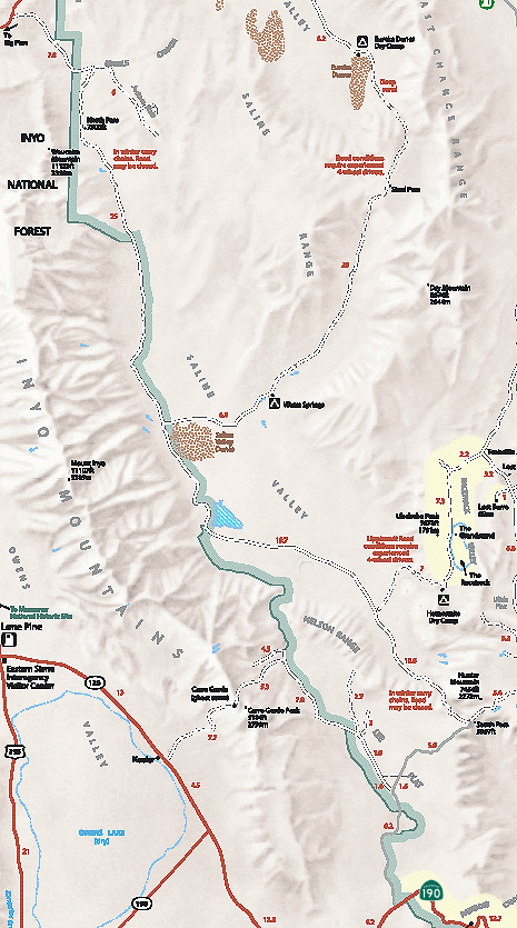
Digital-Desert : Mojave Desert
Intro:: Nature:: Map:: Parks:: Points of Interest:: Ghosts & Gold:: Communities:: Roads & Trails:: People & History:: BLOG:: Weather:: :?:: glossary
Death Valley National Park: Backcountry Roads:

Saline Valley

Route #8
    Vehicle needed:
    high-clearance, but may require 4x4 in winter. Subject to winter closures.

    Distance:
    78 miles from Hwy 190 to Big Pine Road

    Start:
    13.7 miles west of Panamint Springs on Hwy 190

    Camping:
    yes

    Description:
    One of the most remote locations in California, this desert basin is surrounded by rugged mountains on all sides. Finest Joshua tree forest in the park located 8 miles in at Lee Flat. Also salt marsh, sand dunes, warm springs, and stunning views of Inyo Mountains.
Intro:: Nature:: Map:: Parks:: Points of Interest:: Ghosts & Gold:: Communities:: Roads & Trails:: People & History:: BLOG:: Weather:: :?:: glossary
Digital-Desert : Mojave Desert
Country Life Realty
Wrightwood, Ca.
Mountain Hardware
Wrightwood, Ca.
Canyon Cartography
G.A. Mercantile


Grizzly Cafe
Family Dining


Abraxas Engineering
privacy

Disclaimer: Some portions of this project were developed with assistance from AI tools to help reconstruct historical contexts and fill informational gaps. All materials have been reviewed and fact-checked to ensure accuracy and reliability, though complete precision cannot be guaranteed. The aim is to provide dependable starting points and distinctive perspectives for further study, exploration, and research.

These materials are historical in nature and intended for educational use only; they are not designed as travel guides or planning resources.
Copyright - Walter Feller. 1995-2025. All rights reserved.