Mojave Desert History:

Who Is in Charge?

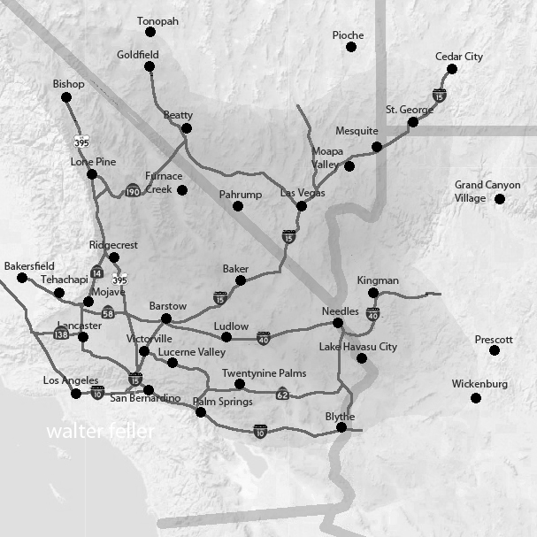
No single government, tribe, agency, or company controls the Mojave Desert. That is the first rule for understanding its history. The Mojave is not one jurisdiction. It is an area with many overlapping authorities. It is older than the borders now drawn. It is still managed piece by piece: by federal land agencies, tribal nations, state governments, county supervisors, city councils, military commands, water districts, railroads, utilities, conservation laws, mining claims, private property, and custom.

Before American maps and agencies, Native peoples held authority over the region. Their homelands, trails, springs, food-gathering areas, trade routes, and river crossings shaped the land. This was not “ownership” in the later courthouse sense; instead, it meant use, memory, obligation, defense, kinship, and sacred geography. The Mojave people controlled key parts of the Colorado River. Paiute, Chemehuevi, Serrano, Cahuilla, Kawaiisu, Timbisha Shoshone, and others were tied to desert and mountain margins. Authority followed water, trails, seasonal movement, and social ties.

Spanish and Mexican authority followed, coming lightly and unevenly. The Mojave was crossed, described, feared, and sometimes claimed. It was not closely governed. Missions, ranchos, military parties, and traders affected the edges and corridors more than the interior. The desert was difficult to occupy in the usual colonial way. Water was scarce. Distances were great. Native people still controlled much of the practical geography.

After the United States took California and the Southwest, authority became more formal but not necessarily more complete. Surveyors, soldiers, miners, freighters, railroad companies, and county officials imposed new systems of control. Military posts guarded roads and river crossings. Mining districts drafted local rules before the full government arrived. Stage and wagon roads made certain corridors important. Counties claimed jurisdiction, but their reach was often thin.

The arrival of the railroad changed the balance of power. The Atlantic and Pacific Railroad, later tied to the Santa Fe system, crossed the Mojave. Authority gathered around depots, water stops, sidings, land grants, and townsites. Places like Daggett, Barstow, Needles, Kelso, and Mojave developed. Transportation created order in a land that had previously resisted centralized control. The railroad did not govern the whole desert. However, it controlled movement, freight, settlement patterns, and economic opportunity.

Mining created another layer. Silver, gold, borax, copper, iron, salt, and other minerals brought camps, claims, mills, roads, and speculation. In many districts, authority came from miners’ meetings, claim notices, local custom, and whoever could pay for extraction and hauling. Over time, state and federal law provided the legal framework. On the ground, the desert was ruled by remoteness, money, water, and endurance.

Homesteading added another layer to authority. The government encouraged settlement through land laws. Much of the Mojave, however, was marginal for farming. Some settlers proved up claims. Some built cabins. Some failed. Some left behind the jackrabbit homestead landscape. Authority here was paper-based: legal descriptions, patents, assessment rolls, roads, school districts, and county maps. But the land itself often had the final word.

In the 20th century, the federal government became the main land authority. National parks, military bases, grazing districts, wildlife refuges, reclamation projects, and later BLM management made much of the Mojave public land. World War II and the Cold War expanded the military presence. Fort Irwin, China Lake, Edwards Air Force Base, Marine Corps bases, and training ranges made the desert a national defense site.

At the same time, water and power authorities became decisive. As a result, projects like the Hoover Dam, the Colorado River system, aqueducts, transmission lines, pipelines, and later solar and wind initiatives connected the Mojave to cities across the Southwest. In this phase, the desert was governed by both land ownership and infrastructure.

Later, the conservation era changed the question of authority again. Laws and designations like the 1964 Wilderness Act, the 1976 Federal Land Policy and Management Act, the California Desert Conservation Area, and the 1994 California Desert Protection Act redefined much of the Mojave as habitat, wilderness, cultural landscape, and public trust. Groups such as the National Park Service, BLM, Fish and Wildlife, state agencies, county governments, tribes, miners, ranchers, off-road users, utilities, conservation groups, and local residents all joined the debate.

Today, much of the California desert is managed by the Bureau of Land Management. Other major areas are under the National Park Service, such as Mojave National Preserve, Joshua Tree National Park, and Death Valley National Park. The military is also a major landholder and decision-maker. Tribal authority is increasingly recognized through consultation, co-stewardship, and co-management, though this is not always done equally or adequately. Counties regulate land use in private and unincorporated areas. Cities govern their own townsites. Water districts, utilities, mining companies, conservation groups, and private owners all hold some authority.

Also, who is in charge?

The best answer is: it depends on where you are, what resource is at issue, and what kind of authority you mean. A ranger can control a campground. A county may control the zoning. A sheriff can enforce local law. The BLM can manage grazing, recreation, mining access, or conservation on public land. The Park Service may regulate activity within a preserve or park. A tribe may exercise cultural, historical, legal, and, sometimes, land-management authority. The military can close an entire landscape. A water district can decide the fate of an aquifer. A railway or utility may control a corridor. A private owner may hold title to a desert square surrounded by public land.

That is the Mojave’s pattern: not centralized command, but layered jurisdiction. The desert has always been negotiated valley by valley, spring by spring, road by road. Its history is people trying to cross it, use it, protect it, extract from it, defend it, name it, and claim it—but never mastering it. Whoever controlled water, movement, maps, law, minerals, military access, or infrastructure controlled part of the desert. But no one controlled it all. The Mojave is best seen not as a single chain of command, but as a contest between landform, use, law, memory, and power.
Transmogrification

Transmogrification, though it carries a slightly literary, almost mythic tone, suggests not just change but a deep and strange transformation into something fundamentally different.

For much of its recorded history, the Mojave Desert was primarily understood as a physical region. Its identity arose from terrain and climate. Dense or permanent human occupation played little role. Early travelers, surveyors, geologists, and writers described it using the language of the landform. They noted broad basins, isolated mountain ranges, dry lakes, volcanic fields, alluvial fans, dunes, washes, and the intermittent course of the Mojave River. The desert was seen as a geographical system. Uplift, erosion, aridity, and distance formed it. Its boundaries were often indistinct. The Mojave was not yet a tightly organized human landscape. It was seen as open country, with character shaped by the land’s form.

In that earlier conception, geography imposed limits upon people. Travel followed springs, canyon mouths, and natural passes through the mountains. Camps and settlements clustered where water permitted survival. Roads bent around lava flows, crossed playas, or traced older Indigenous routes refined over generations of movement through the desert. Human activity existed within conditions dictated by climate and terrain. The desert remained the dominant force, and people adapted themselves to it.

Even with these earliest permanent intrusions, the long-standing dynamic between people and landscape was not immediately overturned. Mining camps rose and disappeared as ore deposits and water supplies fluctuated. Wagon roads faded when springs failed. Small railroad towns appeared abruptly but often remained fragile in the face of the scale and hostility of the surrounding landscape. Much of the Mojave still retained the appearance of a place shaped principally by geology rather than by civilization.

Over time, a shift occurred: the Mojave, once defined by natural systems, increasingly came to be structured around human needs. The first key shift came with railroads, which established artificial centers in previously insignificant locations—places that had mattered only as crossings or water stops. Afterward, elements like highways, aqueducts, transmission corridors, military reservations, utility infrastructure, suburban expansion, recreational development, industrial agriculture along the margins, and large-scale energy production continued this trend. These forces did not simply occupy the desert; they actively reorganized it.

A modern map of the Mojave clearly reveals this shift: vast military boundaries now dominate entire valleys and mountain ranges. Meanwhile, interstate highways create strong directional corridors across what were once diffuse travel landscapes. Utility-scale solar developments, visible for miles, convert open basins into industrial energy fields. Transmission towers march across dry lakes and bajadas. Off-road recreation networks carve repeating tracks into fragile terrain. Finally, conservation areas and national preserves add another layer of organization by establishing access restrictions, managing habitats, providing tourism infrastructure, and developing preservation policies.

Increasingly, the Mojave is understood less through watersheds and landforms than through jurisdiction and use. One valley becomes associated with military training, another with renewable energy, others with recreation, habitat protection, logistics, or suburban expansion. This shift is reflected in the language used to describe the desert. Whereas earlier generations emphasized playas, volcanic mesas, spring systems, or mountain passes, modern discussions focus on renewable energy zones, conservation plans, transportation corridors, protected acreage, groundwater management, housing pressure, and recreational access.

Yet the older desert has not disappeared beneath these overlays. The geology remains the controlling framework beneath every human system. Basin-and-range topography still governs drainage and movement. Mountain ranges still create rain shadows and isolate valleys. Heat still limits settlement density. Water scarcity still defines possibility. Dry lakes still gather runoff after storms, just as they did centuries ago. In many places, the desert resists permanent transformation. Every generation is reminded that the underlying landscape remains older and more powerful than any system laid upon it.

Building on these evolving layers of meaning, what has changed most is not simply the Mojave’s physical appearance but its significance. The desert has shifted in its conceptual role: initially perceived as a natural form, then as a landscape of use, and now increasingly as a landscape of negotiation.

The central question is no longer merely “What is the Mojave?” but “What is the Mojave for?” Different groups now approach the same landscape with competing visions: energy developers see open basins suitable for solar fields and transmission infrastructure; conservationists see fragile ecosystems, migration corridors, and biological continuity; tribes see ancestral homelands, sacred sites, and cultural memory in the terrain itself. The military sees strategic training space, defined by isolation and open airspace, while residents see communities and livelihoods. Recreationists seek freedom, mobility, solitude, and escape, while cities beyond the desert offer land, water, transportation routes, and energy supplies.

As these pressures intensify, nearly every part of the Mojave acquires overlapping claims—emptiness itself becomes contestable. Open land is no longer simply open; instead, it becomes designated, managed, leased, protected, restricted, industrialized, or defended. Consequently, the future Mojave is likely to be shaped not by a single activity, but by tensions among many competing systems, all operating simultaneously across the same terrain.

In this evolving context, the Mojave is entering a third historical phase. Initially, it was defined by its physical landforms. Next, human activities and uses became the defining factors. Now, the Mojave’s identity may increasingly depend on negotiations and conflicts over its meaning, access, and purpose.

The old desert will still remain beneath these arguments. The playas will still whiten under summer heat. Winds will still sweep across creosote flats. Mountain ranges will still rise abruptly from broad basins at dusk. Seasonal floods will still cut across washes after sudden storms. The geological skeleton of the Mojave will endure. However, as human systems become more extensive and entangled, the experience and interpretation of the desert will continue to change.

The future Mojave will be governed as a layered landscape. No single authority will determine its fate: federal agencies will control vast public lands; counties will regulate roads, zoning, and development pressure; tribes will press claims rooted in sovereignty, memory, and sacred geography; energy and mining companies will seek permits, leases, and corridors; conservation groups will defend habitat and species; recreationists will demand access; and residents will argue for the right to live within the desert, not just be managed from outside. In light of these overlapping interests, governance will become less about drawing boundaries and more about arbitrating between claims. The desert will be administered through plans, lawsuits, permits, consultations, closures, leases, and exceptions. Its future will not be decided all at once; instead, it will be determined valley by valley, corridor by corridor, and project by project.

The Mojave functions as both an ancient physical landscape and a modern human one. While it is no longer shaped solely by tectonics, erosion, and climate, it is no longer defined solely by railroads, highways, military reservations, and energy development. Increasingly, the desert is formed by negotiations over how such a landscape should exist. Thus, what once was defined by its form is now shaped by the competing meanings people assign to it.

Telegraph

The First Information Highway

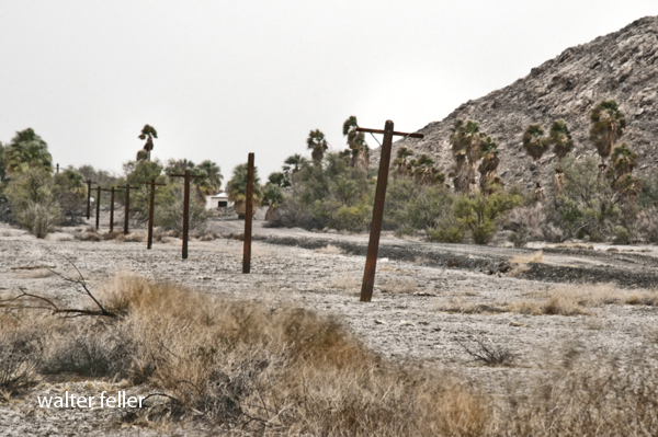
Telegraph poles along the side of the T&T RR roadbed.

Across the Mojave Desert, distance has always been the central challenge, fundamentally shaping the region’s social and economic development. Before the introduction of the telegraph and other forms of rapid communication, travelers, soldiers, and traders moved slowly between scattered springs, river crossings, and mountain passes. Messages traveled only as fast as the horses or wagons carrying them. In this landscape, information lagged behind events, leaving settlements, mining camps, and transportation routes isolated for days. This persistent isolation highlights the importance of the telegraph’s arrival. In this essay, I will examine how the emergence and spread of the telegraph transformed communication in the Mojave, tracing its gradual development, its integration into the transportation and mining infrastructure, and its broader role in connecting the region to the economic and administrative systems of the American West.

The telegraph’s arrival in the nineteenth century transformed communication in the Mojave. As wires were laid alongside railroads and travel routes, the region’s first network emerged—turning settlements and stations into nodes that instantly transported news, business, and personal messages across vast distances. In this way, the once-remote Mojave became part of a coordinated economic and transportation landscape.

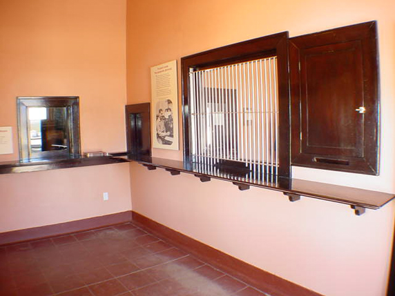
Telegraph room, Kelso Depot

The telegraph lines were more than a technological milestone—they turned the desert’s corridors into channels for movement and information, connecting towns from Needles to Barstow and Mojave as part of a regional network.
To understand this transformation, note that the telegraph’s spread across the Mojave was not a single event but a gradual process spanning several decades. Initially, communication lines traced existing corridors: first, military roads in the mid-nineteenth century; then stage routes; and finally, most decisively, railroads beginning in the 1870s. With each advance, as the wire reached new parts of the Mojave, the effective distance shrank. Consequently, remote stations, mining camps, depots, and river crossings could now report conditions, request supplies, transmit orders, and relay market news in near real time.

Before the telegraph—throughout the early to mid-1800s—communication across the Mojave depended entirely on physical travel. Messages were moved by rider, wagon, stage, or military courier over routes such as the Mojave Road and the Salt Lake Road. Later in the century, they traveled along the wagon corridors tied to San Bernardino, Fort Mojave, and the Colorado River crossings. As a result, delay, uncertainty, and isolation were the norm. For example, a storm, a washout, a hostile encounter, or a shortage of animals could disrupt message delivery for days. In a region where water, distance, and timing mattered, that limitation was severe.

In 1861, the construction of the first transcontinental telegraph line marked a major turning point in American communications, but this initial line bypassed the Mojave. Only after the Civil War, as settlement, military use, mining, and rail transport expanded in the region during the late 1860s and 1870s, did the Mojave begin to develop its own telegraph lines. (Editors, 2009) In the desert Southwest, telegraph lines thrived where regular travel and economic support made maintenance feasible.

Against this backdrop, by the 1870s and 1880s, railroads became the main builders of telegraph infrastructure in the Mojave. As tracks crossed the desert, telegraph poles inevitably followed, since the railroad needed wire as much as rails. To dispatch trains efficiently over long single-track stretches, rapid communication between stations, sidings, yards, and division points became vital. In this way, telegraph offices at depots and section stations became the desert railroad’s nervous system, turning what was once open distance into a managed corridor.

This approach was exemplified by the Southern Pacific’s advance into the greater Mojave in the 1870s. Rail stations were not just stops for passengers and freight; they were communication nodes. A station agent might also serve as a telegraph operator, sending orders, reporting shipments, relaying delays, and linking local businesses to regional markets. Settlements with rail stops often gained telegraphic relevance as well.

The Mojave corridor’s transformation accelerated in 1883, when the Atlantic & Pacific Railroad—later controlled by Santa Fe—completed its line from Needles to Mojave. This milestone marked a decisive moment in regional communication (Atlantic and Pacific Railroad records, 1889-1893, n.d.). With the railroad came a continuous telegraph, linking Colorado River gateways, desert sidings, supply hubs, and western connections. As a result, towns such as Needles, Fenner, Cadiz, Ludlow, Barstow, and Mojave gained new significance—they became points in an interconnected network, not just locations on a map.

As a result of these shifts, Barstow’s later importance rested partly on this logic. As lines converged and railroad functions intensified, so did telegraph traffic. Train movements, freight, maintenance orders, livestock, mining output, and commercial messages all depended on the wire. Telegraphy made Barstow a control point, not just a stopover. The same applied, more modestly, to smaller stations, whose importance stemmed from siding capacity, water supply, or As the route developed into a major rail corridor after 1901, its telegraph infrastructure expanded, and places such as Daggett and the line toward Las Vegas became part of a communications spine linking Southern California with the Great Basin and the interior West (Guide to the San Pedro, Los Angeles & Salt Lake Railroad Company Records, 2024). In turn, the wire made the entire corridor legible to managers, dispatchers, and officials.

As rail and telegraph lines expanded, mining districts also benefited, though typically only indirectly at first. Mines needed access to a telegraph office, whether at their own camp, a nearby rail station, or a supply town—not a full regional grid. In the Mojave, camps often rose and fell too quickly for elaborate infrastructure, but more durable districts spread communication from the railheads. As one mining superintendent observed in an 1882 report, “With the wire to hand, news of strikes or shipments is sent in minutes, not weeks.” Telegraphy enabled ore buyers, investors, freighters, smelters, and operators to coordinate activities far faster than before. The telegraph was an economic multiplier; however, it did not create mineral wealth, but accelerated extraction and speculation.

Beyond its economic impact, the telegraph fundamentally reshaped the exercise of governance in the desert by enabling authorities to coordinate and intervene over long distances far more effectively than before. Sheriffs, military officers, railroad managers, and commercial entities gained the ability to transmit orders, directives, and requests for aid almost instantaneously, enabling more proactive, coordinated responses to emergencies and routine matters alike. The telegraph enabled the rapid management of crises such as accidents, conflicts, floods, labor disputes, supply shortages, and equipment failures. In a region where low population density and vast expanses had previously hindered centralized oversight and delayed administrative actions, the telegraph facilitated more timely decision-making and remote supervision. In effect, telegraphy became not just a technical advance but a core administrative instrument that altered patterns of authority and governance in the Mojave Desert. (Schwoch, n.d.)

Socially, the telegraph drew isolated desert communities into a broader world, fostering new cultural connections and a sense of participation in national affairs. Telegraph offices not only provided access to newspapers, commodity prices, railroad schedules, political news, and personal messages, but also exposed residents to broader currents of information and social change. The resulting increase in awareness allowed Mojave inhabitants to engage more actively with markets, politics, and news beyond their immediate environment. However, it is important to recognize that these benefits were not experienced equally by all residents. Some individuals and communities, particularly those unable to afford telegraph services or lacking easy access to the wire, may have found themselves left further behind as information and economic opportunities flowed to more connected settlements. Although expensive and specialized compared to mail, the telegraph’s symbolic value was enormous, representing technological progress and integration with modern society. (Schwoch, 2019) Nevertheless, while a desert station with a telegraph key was no longer truly remote, those without such infrastructure could remain marginalized—demonstrating that technological advancement could both connect and divide communities within the Mojave. In this sense, the telegraph’s integration sometimes reinforced social and economic disparities, complicating the narrative of universal connectedness and belonging to the broader American experience.

By the early twentieth century, telegraph service across the Mojave had become routine but remained crucial. It laid the groundwork for later advances like telephones and radio, proving that main corridors were channels of information as significant as the rails.

The development of the telegraph across the Mojave can be divided into three clearly defined stages. The first stage, prior to the 1860s, was characterized by a pre-wire desert that relied entirely on courier communication, with messages delivered by riders or wagons. The second stage, spanning the mid to late nineteenth century, marked a transition, as growing military, commercial, and transportation demands increased the need for more rapid communication, prompting the initial spread of telegraph lines along established routes. The third stage began in the 1870s and extended into the early 1900s, when the expansion of railroads led to the widespread installation of telegraph lines along the main transportation corridors of the desert, making telegraphic communication a standard feature of the Mojave (Axotl, 2025). While the telegraph did not conquer the Mojave by itself, its expansion demonstrated a new order: the desert was transformed from a space merely traversed into one constantly monitored, coordinated, and integrated.

By the early twentieth century, telegraph offices at railroad depots relayed train orders and freight movements, connecting desert settlements with distant cities and enabling coordination with markets and administrative centers beyond the desert.

Although later technologies—such as the telephone, radio, and digital communication—replaced the telegraph’s practical role, it is important to remember that the system it created marked a turning point in the region’s history. The telegraph bound the Mojave Desert into the economic and administrative framework of the American West and enabled information to travel as quickly as railroads carried people and goods.

Seen in this light, the telegraph poles that once lined the desert rail corridors represented far more than mere infrastructure. They signaled a profound transformation in the region’s social and economic fabric, marking the Mojave’s entry into the networks that shaped the modern American West.

Alongside the development of railroads and roads, the telegraph fundamentally redefined the meaning of distance and isolation in the desert. By enabling near-instantaneous communication, it not only connected settlements but also facilitated new forms of economic coordination, administrative oversight, and social engagement. Ultimately, the arrival of the telegraph was not simply a technological change: it reimagined the Mojave as part of a broader, interconnected world, demonstrating how technological innovations can reshape both the lived experience and future possibilities of even the most remote regions.

Kern County Timeline

History of Kern County, California (Wallace M. Morgan, 1914):


Pre-1850s

  • Native Yokuts and Serrano tribes inhabit the region, living along rivers and valleys, practicing hunting and gathering.
  • Lieutenant Edward F. Beale later establishes the Tejon Reservation to “civilize” and protect these groups.

1849

  • Naturalist John Audubon travels through the area, recording early observations of wildlife and the potential for settlement.

1851

  • First discovery of gold along the Kern River sparks a regional rush.
  • Miners arrive from southern and northern routes, establishing primitive camps.

1852–1854

  • Quartz mining begins at Keysville; the Keys and Mammoth Mines become notable operations.
  • The first quartz mill is hauled from San Francisco.
  • Mining towns like Whiskey Flat and Kernville emerge.
  • Discovery of the Keys Mine in 1854.

1857

  • California legislature passes a reclamation act for swamp and overflow lands.
  • Early settlers, including Colonel Thomas Baker, began reclaiming the Kern Delta.
  • A major flood reshapes portions of the lower Kern River lands.

1859

  • The site of modern Bakersfield is first identified.
  • Early cattlemen and settlers began to locate along the delta.

1860s

  • Havilah was founded as a mining center and later became the first county seat.
  • Immigrant roads and stage lines cross the valley.
  • Floods of 1867–68 create temporary lakes and swamps; drainage projects follow.
  • Early schools and cotton crops were established.
  • Outlaw Tiburcio Vasquez operates in the region; wild-horse catching is common.

1866–1870

  • Transition from placer mining to agriculture and stock raising.
  • Swamp land patents granted to Baker and others.
  • Ranching and sheep industries expand.

1868–1872

  • Kern County formally created from parts of Tulare and Los Angeles counties.
  • County seat at Havilah; first county officials elected.
  • Colonel Baker becomes prominent in reclamation and civic improvement.
  • 1872: Death of Colonel Thomas Baker, widely regarded as the founder of Bakersfield.

1873–1876

  • Bakersfield wins the county seat election (1874).
  • Town incorporated (1873) and disincorporated (1876).
  • Havilah declines; Bakersfield begins steady growth.
  • Early capitalists such as Livermore and Redington invest in local enterprises.

1877

  • Severe drought devastates the county’s cattle and farming interests.
  • Settlement expands in Tehachapi; first apple orchards planted.

1878–1885

  • Water rights disputes intensify between Haggin, Carr, Miller & Lux.
  • Major court cases begin over Kern River usage.
  • Construction of irrigation ditches and canal systems begins.
  • Early colonization efforts launched.

1880s

  • Tehachapi develops as a railroad and agricultural community.
  • Lynchings and outlaw conflicts occur during this rough period.
  • Bakersfield experiences a fire and rebuilding effort.
  • Introduction of electricity and other public utilities.

1890–1895

  • Mining resurgence: discovery of the Yellow Aster Mine at Randsburg.
  • Other desert mining districts (Amalie, Tungsten) discovered.
  • Bakersfield gains street railways and gas/electric utilities.
  • Great railway strike affects local commerce (1894).

1899

  • Discovery of oil near McKittrick and Sunset; first wells drilled.
  • Beginning of Kern County’s modern oil era.

1900–1905

  • Kern River oil field developed; Elwood brothers credited with major discovery.
  • Early pipelines and refineries built.
  • Bakersfield begins paving, civic expansion, and population growth.

1906–1910

  • Lakeview gusher (1910) becomes one of California’s largest oil strikes.
  • Consolidated Midway and North Midway fields expand.
  • Gushers flood markets; oil regulation and conservation efforts start.
  • Bakersfield experiences building boom; new roads and public buildings constructed.

1911–1913

  • Pump irrigation develops in valley towns like Wasco and McFarland.
  • Citrus and apple industries expand.
  • Bakersfield and Kern consolidate as one municipality.
  • Bonds issued for paved roads and infrastructure.
  • County churches, schools, and civic institutions flourish.

1914

  • Publication of Morgan’s History of Kern County marks the county’s transition from frontier to industrial modernity.
  • Bakersfield stands as the regional center of oil, agriculture, and commerce.

Kern County

The Archive and the Conversation

A Living Record

The Mojave Desert is the central thread, but the archive is more than just a storehouse of facts about the land. It’s a layered record, part historical survey, part natural history guide, and part personal journal. The archive contains thousands of entries, ranging from carefully produced histories of ghost towns to quick, almost casual notes about desert wildflowers. It also includes the memory of conversations, some technical, some reflective, all contributing to a living body of knowledge.

The current archive carries these notes forward. They do not simply add new entries; they revisit and renew older ones. When you ask about Scotty’s Castle, it’s not only a summary of a landmark in Death Valley but also a chance to look again at Walter Scott’s fabricated gold mine, his staged shootout at Wingate Pass, and the way his friendship with Albert Johnson turned into one of the strangest desert partnerships. That reflects the way your archive works: history is never sealed off, but constantly connected to other stories. Scotty’s fake mine ties to mining history, con men, railroad investors, and the enduring myths of the desert.

Other chats anchor themselves in place. Marl Springs, for example, appears not just as a dot along the Mojave Road but as a critical water source, garrisoned by soldiers in 1867 and attacked in the same year. The description in your archive emphasizes its clay-like soil and its dependable, if limited, water supply. The chat adds motion to that entry by pulling the soldiers into view, by describing how isolated Marl Springs was from Soda Springs to the west, and by noting how wildlife still depend on its water. Here, the archive preserves detail, while the conversation reanimates it.

Afton Canyon is another recurring subject. The archive refers to it as the Grand Canyon of the Mojave, formed approximately 15,000 years ago when Lake Manix drained catastrophically. The chats bring it alive with more than geology. They highlight the Mojave River flowing above ground, the slot canyons and caves, the risks of flash floods, and the chance to hike and watch wildlife. The personal tone slips in here: Afton is not just an entry on a map; it is a place walked, seen, and photographed. This blend of technical and personal is one of the hallmarks of your work.

Rainbow Basin provides another good example. In the archive, it is a geologic site featuring badlands and folded rock, as well as paleontological finds and fragile soils. In conversation, it becomes a vivid picture of color bands, rattlesnakes, and the eerie feel of hiking through formations shaped by time and water. The description is simplified for younger readers when needed, but the detail remains. It is both a science lesson and a story about walking through the basin yourself.

The archive also gives weight to local communities and their histories. Cajon Pass, for instance, is not simply a route. It is a crossroads layered with stories: Rancho Muscupiabe, Mormon pioneers, the Santa Fe and Southern Pacific railroads, the old wagon roads, the geology of Lost Lake and Blue Cut. Chats about Cajon Pass often focus on its function as a gateway, a place where history, geology, and transportation come together. They show how the archive not only stores information but also draws connections, creating a network of meaning.

The same goes for Old Woman Springs. The archive notes its name, given by surveyors who saw Indian women there. It records Albert Swarthout’s ranching operation, the cattle drives through Rattlesnake Canyon, and the later disputes with J. Dale Gentry. In chat, the place becomes more than history. It becomes a story of how ranching shaped the Mojave, how land ownership shifted, and how the desert landscape still carries those traces.

Other places appear again and again, sometimes as historical notes, sometimes as subjects for simplified explanations. Shea’s Castle in the Antelope Valley, built by Richard Shea in hopes of curing his wife’s illness, ruined by the stock market crash, later a film set. Hotel Beale in Kingman is tied to Andy Devine, the actor whose name became linked to Route 66. Oasis of Mara in Twentynine Palms is a site of Native planting, early settlement, and eventual park development. Each of these places carries weight in the archive, but they come alive in conversation, as the details are retold, refined, and made accessible.

Ecology is just as present as history. Pinyon pines and junipers, Fremont cottonwoods, brittlebush, desert sunflowers, bees sleeping in flowers, and ‘horny toads’ explained to children — all of these details show how the archive ranges across subjects. A glossary entry on igneous rocks can sit beside a playful description of bees tucked into golden blossoms for the night. A technical note on pinyon-juniper woodland succession can be followed by a casual story about antelope ground squirrels darting through camp. These shifts in tone are part of the richness of the record.

The archive also holds larger arcs. The history of Owens Valley runs through it: the water conflicts with Los Angeles, the aqueduct, the treaties with Native peoples, the battles fought during the Owens Valley Indian War. Panamint City and Greenwater appear as examples of boom and bust, with detailed accounts of stagecoach robbers, Nevada senators, mining camps, and the short-lived hopes of investors. The Tonopah and Tidewater Railroad, Remi Nadeau’s freight road, and the Atlantic and Pacific’s push across the Mojave all weave together into the bigger story of transportation. These arcs show how your archive is not just about single places but about the way places link into broader regional histories.

The present chats extend these arcs. A question about Owenyo might focus on its railroad history, but in doing so, it links back into Owens Valley and forward into the decline of rail in the desert. A question about Llano del Rio touches both the socialist dreams of Job Harriman and the modern ruin that still draws visitors. Each chat is both a piece in itself and a way of extending the larger web.

Throughout, there is an awareness of presentation. The archive is not simply a private notebook. It is shaped to be shared: titles, descriptions, metadata, glossaries, indexes. Chats often focus on how best to present this material to readers, whether as timelines, simplified summaries, or relational indexes. The act of shaping the material for public use is part of the archive itself.

The combination of archive and chat also reflects a deeper concern: preservation. The desert is full of forgotten places, and people who once told their stories are no longer around. By recording these histories, revisiting them, and reshaping them for new audiences, the archive resists that loss. The chats show the urgency of this work, as you reflect on volunteers thinning out, museums struggling, and the need to keep the desert’s stories alive.

The archive is a landscape in itself. Its mesas are the long, detailed histories. Its washes are the short, playful notes. Its valleys are the connections between subjects. The chats are the weather moving across that landscape, stirring it, reshaping it, sometimes eroding, sometimes depositing. Over time, the whole thing grows richer, more interconnected, more alive.

This is why the archive and chats cannot be separated. The archive preserves. The chats enliven. Together they form a record of both the desert and of the act of remembering. The Mojave is the subject, but the deeper theme is persistence: the persistence of asking, recording, and shaping knowledge into something that lasts.

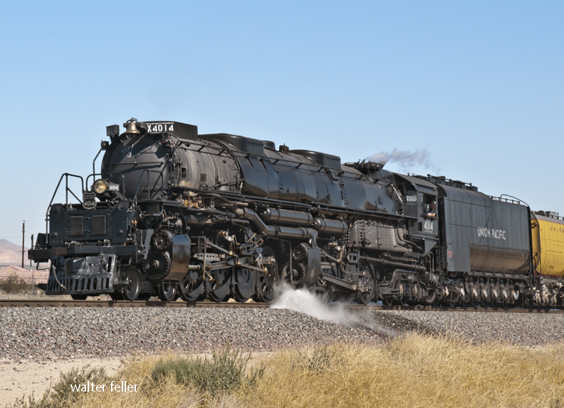
Big Boy 4014

The Union Pacific Big Boy 4014 is one of the largest and most powerful steam locomotives ever built. Part of the Big Boy class, it was constructed in the early 1940s by the American Locomotive Company (ALCO) to haul heavy freight over steep grades in the Western U.S., especially in the Wasatch Mountains. These locomotives are huge, measuring over 132 feet long and weighing around 1.2 million pounds.

Big Boy 4014 was retired from service in 1961, but in 2013, Union Pacific reacquired and restored it. Today, 4014 is fully operational and runs on special excursions, thrilling train enthusiasts with massive size and power. Its restoration was a significant feat, marking the return of one of the most iconic steam locomotives in history.

The Big Boy series, including 4014, represents the peak of steam locomotive technology and the golden age of railroading in the U.S.

4o

Barstow Index

Barstow California Area

digital-desert.com › barstow

Barstow Area. Barstow lies in the intersection of the three largest ecosubsections in the Mojave Desert; High Desert Plains & Hills (322Ag), Mojave Valley – …

Barstow, California

digital-desert.com › barstow-ca

Barstow 1890. Barstow is situated at the junction of the California Southern and the A. &. P. Railway, eighty-two miles from San Bernardino and twelve miles …

Kramer Junction (Four Corners) Mojave High Desert

digital-desert.com › kramer-junction-ca

3) Go west on the State Route 58 through Boron, Mojave or California City and up to Tehachapi and over the Southern Sierra. 4) Go east to Barstow. There is food …

Vanyume Indians

mojavedesert.net › vanyume-indians

Mojave Desert Indians – Map. Vanyume Indians. The Vanyume or Beñemé, as Father Garces called them, lived beyond and along much of the length of the Mojave …

Casa del Desierto

digital-desert.com › casa-del-desierto

Casa del Desierto – Harvey House. Barstow Harvey House and train station photo – Casa del Desierto Casa del Desierto: The Spanish for “House of the Desert” In …

Barstow, California – Notes

digital-desert.com › blog

Nov 4, 2023  Today, it remains an essential point of access and commerce for those traveling through the Mojave Desert in Southern California. Post Views: 12.

Goldstone, Barstow California, Mojave Desert

digital-desert.com › goldstone-ghost-town

Goldstone Ghost Town. More of a site than a ghost town, there are only a few scattered foundations and some rubble to be found. The area is now home to NASA’s …

History of Barstow the National Old Trails Road and Route 66

digital-desert.com › barstow-ca › moving-barstow

The Barstow yards are used jointly by the Santa Fe and Union Pacific and handily very considerable volume of the transcontinental traffic. Hence the railroad …

Barstow, Ca Historic Photos

digital-desert.com › barstow-ca › historic-photos

Burton Frasher photos of Barstow, California.