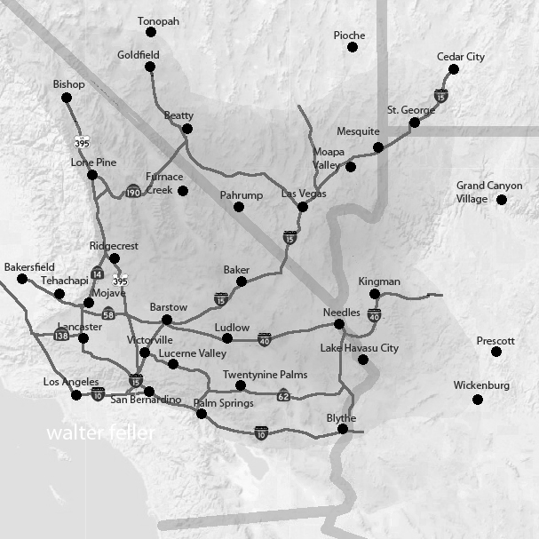
When Bees Sleep

Things to say to a seven-year-old

In the Mojave Desert, the bright yellow desert gold flowers open wide in the sunshine. They look like little suns shining across the sand. Bees love to visit, buzzing from one bloom to the next, sipping sweet nectar and rolling in golden pollen.

As the sun sinks low, the flowers start to close their petals. It’s bedtime for desert gold. But sometimes, a bee is still inside. When the petals fold shut, the bee is tucked in—safe and snug in a soft bed of pollen. The flower becomes a tiny motel room just for bees.

On windy nights, the motel isn’t always calm. The flower sways and shakes, tossing the bee about like a boat on stormy water. That’s what makes it “wild” life. But even if it gets bumpy, the bee is better off inside than out in the cold desert night.

Bees are hard workers with a wonderful work ethic. They don’t even leave the job when it’s time to rest. They sleep right at work, in golden beds of pollen. And when the morning sun warms the desert and the flowers open again, the bees are already up and ready—buzzing off to do their important work all over again.

Sunflower

Damn Yellow Flowers

Rancho Lucerne

In the early 1990s, Rancho Lucerne was introduced as an ambitious master-planned development for Lucerne Valley. The proposal covered nearly 1,400 acres and envisioned 4,257 homes, a 27-hole golf course, and commercial amenities. A Draft Environmental Impact Report was released in 1993, and early grading even took place near the high school. To its backers, Rancho Lucerne promised to transform the valley from a quiet agricultural community into a suburban center.

But the project unraveled almost as quickly as it appeared. The financier behind Rancho Lucerne was charged with embezzlement, money dried up, and by 2001 the plan was abandoned. What remained was a scar of disrupted desert soil, a reminder of what might have been.

At first glance, this collapse may have seemed like a failed opportunity for growth. In reality, it became a turning point that preserved Lucerne Valley’s traditional identity. Without Rancho Lucerne, the valley avoided the massive shift toward suburban sprawl. Instead, it stayed closer to its roots—scattered ranch homes, small farms, alfalfa fields, and open desert stretching to the horizon. Growth continued on a modest, individual scale, with new homes built one lot at a time rather than through sweeping developments.

The deeper reason for resistance lay in water. Lucerne Valley relies on its underground aquifer, a fragile supply that has always been stretched between farms, families, and the desert ecosystem. A project of Rancho Lucerne’s scale—thousands of houses and a golf course—would have drawn heavily from this source. For many locals, that alone made the project unsustainable. By failing, Rancho Lucerne spared the valley from a major new demand on its water, leaving space for the slower pace of development that better fits the desert.

Even today, when the project resurfaces in planning discussions, conservation groups such as the Morongo Basin Conservation Association push back, citing water, wastewater, air quality, traffic, cultural resources, and environmental justice. The mood of the community leans strongly against large-scale development. Rancho Lucerne has become a kind of cautionary tale: a reminder that the valley’s future is best secured by honoring its agricultural heritage and protecting its limited resources.

Looking back, the unbuilt project didn’t just fade into history—it helped define the community’s values. By collapsing, Rancho Lucerne reinforced the belief that Lucerne Valley’s strength lies not in suburban expansion but in its rural heart, where water, land, and tradition are treated as treasures too rare to gamble away.

Lucerne Valley

Mojave: Nature or Nurture

If you’re wondering whether the Mojave Desert is shaped more by nature or human influence, the answer is a combination of both. However, nature has had the predominant role for much longer.

Over millions of years, nature has carved out the Mojave, sculpting its landscapes through the forces of wind and water. It has created mountain ranges, valleys, and ancient lakebeds, setting the stage with extreme temperatures, limited rainfall, and hardy plants and animals that have adapted to survive in this challenging environment. Species like Joshua trees, creosote bushes, bighorn sheep, and sidewinder rattlesnakes have all found a way to thrive in a land where survival is not guaranteed.

In contrast, humans have made their mark in a much shorter timeframe. Indigenous peoples, such as the Chemehuevi and Mojave, lived sustainably in the region, moving with the seasons and utilizing the land’s resources without depleting them. Later, settlers, miners, ranchers, railroad builders, and modern developers added further layers of change. Some areas, like Las Vegas, military installations, and sprawling solar farms, have undergone significant transformation. In contrast, other regions remain relatively untouched, preserving their raw, ancient beauty.

So, is the Mojave a product of nature or nurture? Nature formed it, while humans have made adjustments—sometimes respecting its limits and other times pushing them. Regardless of how much we build or alter the landscape, the desert continues to adhere to its own rules. Flash floods serve as reminders of the power of water, sand dunes shift and reclaim the land, and scorching summer temperatures demonstrate who is truly in charge.

Digital-Desert & Mojave Desert .Net

The digital-desert.com and mojavedesert.net sites share the same subject matter and similar structure, dealing with the Mojave Desert and surrounding regions. Both of them provide learning materials, exploration tools, and information on history.

Here are the main parts that make up both sites:

1. Natural History Geology: Rock formations, fissures in the earth (such as the San Andreas Fault), volcanic activity, and desert patterns. Lake systems (e.g., former Lake Manix and dry lakes such as Soda Lake).

Ecology: Plants and animals that live in desert environments include Joshua trees, creosote bushes, desert tortoises, and bighorn sheep. Habitats include sand dunes, salt flats, canyons, and oases.
Climate: Desert weather patterns include very hot temperatures, seasonal rain, and wind events.

2. Human History Native American Culture: Tribes such as the Mojave, Chemehuevi, Serrano and Paiute. Rock art, traditions, and trade routes such as the Old Mojave Trail. Explorers and Pioneers: Tales of explorers like Jedediah Smith, Kit Carson, and Father Garces. Principal routes: Mojave Road, Spanish Trail, and Butterfield Overland Mail. Mining History: Gold, silver, and borax mining expand rapidly. Specific mining towns and operations are Calico, Rhyolite, and Boron. Historic Places and Ghost Towns: Places like Kelso Depot, Ballarat, and Pioneer Town. Old abandoned buildings, stage stops, and rail history.

3. Geography and Exploration Areas and Landmarks: Joshua Tree National Park Death Valley Mojave National Preserve and Rainbow Basin. Special shapes such as the Devil’s Punchbowl, Afton Canyon, and sand hills. Streets and Roads: Route 66, Old Mojave Road, and gorgeous roads. Hiking and driving routes with maps and information. Interactive Maps: Topographic and historical maps depicting routes of exploration and other localities.

4. Cultural Characteristics Towns and Communities: Tales of desert towns such as Barstow, Victorville, Littlerock, and Needles. Key Players: The area called Death Valley housed early settlers and miners, even famous dudes like Roy Rogers. Art and Folklore: Desert-themed art installations, legends (e.g., ghost stories, lost mines) and folklore.

5. Learning and Information Photos and Pictures: Large photo galleries of desert landscapes, animals and abandoned places. Field Guides: Resources for identifying plants and animals. History Timelines: A summary of geological, prehistoric, and modern historical events. Resource Links: References to books, museums and archives for further research.

6. Fun Guides Camping and Hiking: Lists of campgrounds, remote places, and summaries of hiking trails.
Driving Tours: Ideas for a nice road trip with important places to see.
Safety and Preparation: Tips for desert exploration, including hydration, navigation, and safety around wildlife.

While digital-desert.com focuses on exploration and natural beauty through detailed guides and maps, mojavedesert.net often has a more structured historical narrative and cultural focus. Both sites are resources for desert enthusiasts, historians, and educators.

California to Salt Lake City

THE OVERLAND MAIL
1849-1869
Promoter of Settlement
Precursor of Railroads by
LE ROY R. HAFEN, PH.D .
Historian, The Stale Historical and Natural History Society of Colorado

The first United States mail between California and Salt Lake City was established in 1851. This route was advertised January 27, 1851, and the thirty-seven bids received ranged from $20,000 for “horseback or two horse coach service,” to $200,000 per year for service with ” 135 pack animals with 45 men, divided into three parties.” One bid was for a four-horse coach with a guard of six men, at $135,000 per year. The lowest bid was accepted and a contract was made in April with Absalom Woodward and George Chorpenning for a monthly service at $14,000 per year; the trip each way was to be made in thirty days. No points were designated at which the route should touch, but it was to go “by the then traveled trail, considered about 910 miles long.”

Chorpenning and his men left Sacramento May 1, 1851, with the first mail. They had great difficulty in reaching Carson valley, having had to beat down the snow with wooden mauls to open a trail for their animals over the Sierras. For sixteen days and nights they struggled through and camped upon deep snow. Upon reaching Carson valley, Chorpenning staked off in the usual western manner, a quarter section of land and arranged to establish a mail station. The town of Genoa, Nevada, grew-up on this site. Chorpenning and several men continued eastward and reached Salt Lake City June 5th, having been delayed somewhat by snow in the Goose Creek mountains.

Throughout the summer, difficulties were experienced with the Indians; and Woodward, who left Sacramento with the November mail, was killed by them just west of Malad River in northern Utah. The December and January mails from Sacramento were forced to return on account of deep snow, but the February (1852) mail was pushed through by way of the Feather River Pass and reached Salt Lake City in sixty days. The carriers endured frightful sufferings; owing to the fact that their horses were frozen to death in the Goose Creek mountains, they had to go the last two hundred miles to Salt Lake City on foot. Permission was obtained from the special agent in San Francisco to send the March mail down the coast to San Pedro and thence by the Cajon Pass and the Mormon trail to Salt Lake City. During the summer of 1852 the service continued to be performed across northern Nevada by way of the Humboldt River; but as winter approached, arrangements were made with the mail agent at San Francisco to carry the Utah mail via Los Angeles during the winter months. The Carson valley post office was supplied monthly by a carrier on snow-shoes. Fred Bishop and Dritt were the first carriers and they were succeeded by George Pierce and John A. Thompson. The latter, “Snowshoe Thompson,” a Norwegian by birth, made himself famous in this section by his feats on snow-shoes during succeeding winters. The shoes used were ten feet long and of the Canadian pattern. He often took one hundred pounds upon the journey between Placerville and Carson, and made the trip in three days to Placerville and the return journey in two days.

With the interruption by bad weather of the mail service east of Salt Lake City, the mail was sent westward to San Pedro, where it was transmitted by steamer to the Atlantic seaboard. This increased the weight of Chorpenning mail from about one hundred pounds to about five hundred pounds. For this additional service Chorpenning made claim and in 1857 received payment on a pro rata basis.

The causes of the irregularity and interruption of the mail service to Utah had not been explained to the Postmaster-general by the Special Agent at San Francisco and so, upon the grounds of the derangement of the service, the Postmaster-general annulled the contract with Chorpenning, and made one with W. L. Blanchard of California. The new contractor was to receive $50,000 per year, and was to maintain a fortified post at Carson valley. Upon learning of this new arrangement in January, 1853, Chorpenning set out for Washington and, after setting forth his case before the new Postmaster-general, was reinstated. A verbal agreement was made that the compensation should be increased to $30,000 per year and permission was given to carry the mails via San Pedro during the winter months.

During the first three years (1851-4) the Utah-California mail was carried except in winter, by the old emigrant route. This route lay from Sacramento
through Folsom, Placerville, along the old road through Strawberry and Hope valleys to Carson valley. From this point it led to the Humboldt, which stream
was followed nearly to its source. Leaving the Humboldt the route led northeastward into southern Idaho in the vicinity of the Goose Creek mountains, and thence southeasterly around the north side of Great Salt Lake to Salt Lake City.

In the lettings of 1854, the Utah-California mail route was changed to run from Salt Lake City over the Mormon trail to San Diego. Chorpenning was again the successful bidder. The mail was to be carried monthly each way, through in twenty-eight days, for a compensation of $12,500 per year. Chorpenning thought it worthwhile to enter a low bid to ensure getting the contract since he expected that the service would probably be increased to a weekly schedule, the time per trip reduced, and the compensation increased.

The service began July 1, 1854, and was to continue for four years. The mail was carried on horseback or on pack mules. During that first summer, Indian difficulties arose and continued at intervals for months. The emigration fell off and expenses on the route increased. Similar difficulties had been encountered by the contractors east of the Rocky Mountains, who appealed to Congress and received increased remuneration by the act of March 3, 1855. Encouraged by their success with Congress, and inasmuch as his difficulties continued, Chorpenning went to Washington and presented his claims in June, 1856. Congress responded with an act for his relief March 3, 1857. It provided that the compensation be increased to $30,000 per year from July 1, 1853, to the termination of the contract in 1858; that the full contract pay be allowed during the suspension of the contract in the spring of 1853; and that the Postmaster-general make an additional allowance on a pro rata basis for the extra service performed prior to 1853. A total of $109,072.95 was allowed and paid under the provisions of this act.

During the four years of the duration of the contract (until July i, 1858), the mail was carried with fair regularity, and often in less than schedule time. The service was usually performed on horseback, but a wagon was used occasionally. The mail of December, 1857, was taken from Salt Lake City to Los Angeles by wagon in twenty-six days, while on horseback the trip often did not consume more than twenty days.

Wells Fargo and Company, Adams and Company, and other express companies maintained express service on the line during this period (1854-8). There was also much freighting and some emigrant travel over the road. The Mormon “State of Deseret” had included the whole of this route with its terminus upon the Pacific Coast. A colony was planted by these pioneers at San Bernardino in 1851 and considerable trade and intercourse was carried-on over this road.

The route was in general that of the present “Arrowhead Trail” automobile road. From Los Angeles the route led to San Bernardino, through Cajon Pass to the Mohave River, which was followed for fifty miles. From the Mohave River the route lay to the north to Bitter Springs, then turned eastward by Kingston Springs to Las Vegas, Nevada. From this famous resting station a dry stretch of sixty miles was crossed leading to the Muddy Creek. After crossing another “bench” the Virgin River was reached, and this stream was followed to Beaver Dams, Arizona. Leaving the Virgin River the road crossed the “slope” and over a little mountain range to the Santa Clara Creek, which stream was followed to the vicinity of the famous Mountain Meadows. From Mountain Meadows the route led to Cedar City and thence almost due north through the Mormon settlements of Parowan, Beaver, Fillmore, Nephi, Payson, Provo, and Lehi to Salt Lake City.”

Before the termination of the contract on this route the policy of extensive increases in the western mail lines was inaugurated, and partisans of the “Central Route” via Salt Lake City and across northern Nevada were demanding service upon that more direct route to San Francisco. Accordingly, in 1858 this Los Angeles to-Salt Lake City route was discontinued and the original route of 1851 was re-established and put upon an improved basis.

The Evolution of Muroc: From Desert Wasteland to Aviation and Racing Hub

Geological and Environmental Background

Pleistocene Era (circa 2.5 million years ago) The origins of Rogers Dry Lake, located in the Antelope Valley within the Mojave Desert, trace back to the Pleistocene Era, around 2.5 million years ago. As a pluvial lake, it boasts an incredibly flat, smooth, and hard surface, which can withstand pressures up to 250 psi. These unique geological characteristics made Rogers Dry Lake a natural choice for aviation and automotive speed trials. Covering approximately 65 square miles, the lakebed forms a rough figure eight and is known for its harsh climate, experiencing extreme temperatures, violent dust storms, and mesmerizing sunsets.

Early Settlement and Development

Pre-1876: Sparse Population and Railroad Expansion Before significant settlement, the area was primarily inhabited by occasional prospectors searching for mineral wealth. The Southern Pacific Railroad established a water stop near the lakebed in 1876. In 1882, the Santa Fe Railroad extended westward from Barstow toward Mojave, establishing another water stop at the edge of what was then called Rodriguez Dry Lake. By the early 1900s, the name “Rodriguez” had been anglicized to “Rogers.”

1910: The Corum Family and the Founding of Muroc In 1910, the Corum family settled at the lakebed, naming the area “Muroc” by reversing their last name after their original choice, “Corum,” was rejected due to its similarity to “Coram, California.” The Corum family established a general store and post office, attracting other homesteaders and helping to develop the area. Their efforts laid the foundation for what would become a significant site in both aviation and automotive history.

Early Racing Events

1920s: The Dawn of Speed Events Muroc Dry Lake became a prominent site for American Automobile Association (AAA) sanctioned speed events during the 1920s. The affordability and modifiability of the Model T made it the preferred vehicle for early hot rodders. Roadsters were favored among racers, but touring cars were also frequently raced. In May 1923, Joe Nikrent set a speed record of 108.24 miles per hour in a stripped-down Buick. The following year, Tommy Milton achieved 151.26 mph in a Miller-powered race car. In 1927, Frank Lockhart reached a speed of 171 miles per hour, further cementing Muroc’s reputation as a premier racing venue.

October 9, 1927: Southern California Champion Sweepstakes One of the most significant early racing events was the Southern California Champion Sweepstakes, held on October 9, 1927. Organized by Earl Mansell from Pasadena, California, the event featured five classes of competition:

  1. Ford Roadsters: Open to any Ford roadster with or without fenders or windshields, requiring a hood and turtle deck.
  2. Ford Coupes: Required fenders, hood, windshield, and doors.
  3. Ford Touring Cars: Fenders and windshields were optional.
  4. Special Flathead Race: Open to any body style with a flathead engine, offering refunded entry fees to winners of the previous events.
  5. Championship Sweepstakes: Open to any roadster, coupe, or touring car, with the option to race without windshield or fenders.

Organized Racing and the SCTA

1931: The First Organized Speed Trials In 1931, one of the first known organized amateur speed trials took place at Muroc, sponsored by Gilmore Oil Company of Los Angeles and organized by George Wight, owner of Bell Auto Parts. Recognizing the need for coordinated rules and regulations, Wight invited hot rodders to an organizational meeting in East Los Angeles. Early rules categorized cars based on engine types, including Model T flatheads, Model T Rajos, Model T Frontenacs and Chevrolets, Model A flatheads, and Model A overhead valve conversions. Supercharged cars were not allowed to compete. The first organized meet was held on March 25, 1931, followed by another on April 19, 1931. Safety measures were implemented, such as a 40 mph speed limit for returning cars and penalties for jumping the start.

Formation of the Muroc Racing Association By the end of 1931, the Muroc Racing Association was formed, complete with officers and a race program. The association collected a one-dollar entry fee to cover expenses, and the Purdy Brothers developed an electrical timer to clock the cars’ speeds, further formalizing the events.

1932-1933: Changes in Classification In 1932, the trials continued under the same rules, but significant changes in car classification were introduced. Cars were now categorized as either stock-bodied or modified. Stock-bodied cars could have certain parts removed, while modified cars were significantly altered. Between the 1932 and 1933 seasons, classifications shifted to speed and body type, with new classes based on potential top speeds. This change aimed to ensure fairness and safety, with measures like painting speedometers with white shoe polish to prevent drivers from knowing their exact speed.

Military Establishment and World War II

September 1933: The Arrival of the Army In 1933, the United States Army arrived at Muroc, recognizing the lakebed’s potential as an airfield. The Muroc Bombing and Gunnery Range was established, and by 1937, the United States Army Air Corps set up Muroc Air Field for training and testing purposes.

World War II and the Establishment of Muroc Army Air Base During World War II, Muroc Army Air Base was activated, serving as a major training site for bomber crews and fighter pilots. The flat, hard surface of Rogers Dry Lake was ideal for aircraft testing, including early jet planes like the Bell XP-59A and the Lockheed XP-80. On October 1, 1942, the Bell XP-59A Airacomet, America’s first jet plane, made its first flight at Muroc. The base played a crucial role in the war effort, training crews and testing new aircraft.

Post-War Developments After the war, Muroc continued to be a central hub for aviation research and development. The Bell X-1, piloted by Capt. Charles E. “Chuck” Yeager, broke the sound barrier on October 14, 1947, marking a significant milestone in aviation history. The base was renamed Edwards Air Force Base in February 1948 in honor of Capt. Glen W. Edwards, who died in a test flight accident. By 1950, Edwards Air Force Base was officially dedicated and recognized as the U.S. Air Force Flight Test Center (AFFTC).

The Hot Rodding Era

Post-War Racing and El Mirage The end of World War II marked a transition from racing activities at Muroc to El Mirage, another dry lakebed south of the air base. While El Mirage was not as ideal as Muroc, it continued to host hot rodding events. The SCTA (Southern California Timing Association) organized several “reunion” races at Muroc in 1995, bringing together a generation of racers who had participated in early SCTA events. However, racing activities at Muroc were halted following the events of September 11, 2001, due to security concerns.

Legacy and Continued Significance

Aviation and Hot Rodding Heritage Muroc’s dual legacy as a pioneering site for both aviation and hot rodding remains significant. Edwards Air Force Base continues to be a premier flight testing center, contributing to numerous advancements in aerospace technology. Meanwhile, the early days of hot rodding at Muroc are fondly remembered by enthusiasts and are considered a foundational period in the history of American motorsports.

Current Status and Future Prospects While racing activities at Muroc have ceased, El Mirage remains an active site for hot rodding events. The SCTA continues to organize races, preserving the spirit and tradition of early speed trials. There is hope that, in the future, Muroc might once again host racing events, allowing the sands to echo with the sounds of high-speed automotive competition.

In conclusion, Muroc’s history is a testament to its unique geographical features and its adaptability, serving as a critical site for both military aviation and automotive racing. The integration of these diverse historical elements highlights Muroc’s significant contribution to American technological and cultural heritage.

The Mourning Dove Song

Three short, sad notes the Mourning doves call to each other from bunches of thick green leaves in the cottonwood trees. The heat pushes up the canyon, and the bright sun chases the shadows into themselves the way a mirage disappears as you approach.

Boots crunched softly in the thick sand along the trail and spotted lizards dart frantically in the low scrub. The pointed ears of a coyote catch your attention as it leaps over a clump of gray grass to pounce on a squirrel eating a seed. A tortoise marches on steadfastly and fearless in his search for a mate. A cottontail nibbles on a juicy young leaf and listens closely to every scratch and pop.

The late morning finally gives way, and high noon approaches as bold as a bully. The air is clear and hot. The sun burns the back of your hands, bringing salt to your dry lips. Your forehead tingles; you push the brim of your hat back and tilt your head forward a bit to keep your face in the shade.

w.feller

Stage Stops & Relay Stations

Stagecoach relay stations and accommodations were vital for the stagecoach travel system, especially during the 18th and 19th centuries. These stations were strategically located along stagecoach routes to ensure efficient travel and the well-being of passengers, horses, and drivers.

Relay Stations

Relay stations, also known as “staging posts” or “stage stops,” were positioned every 10 to 20 miles along the route. Their primary purpose was to provide fresh horses for the stagecoach, as they would be exhausted after traveling long distances. At these stations, tired horses were replaced with rested ones, ensuring the stagecoach could maintain a steady pace without long delays.

Key features of relay stations included:

  • Stables: For housing and caring for horses.
  • Feed and Water: Ample supplies of food and water for the horses.
  • Blacksmith Services: For shoeing horses and making necessary repairs to the stagecoach.
  • Shelter: Basic accommodations for passengers if they need a brief rest.

Accommodations

Beyond just relay stations, more substantial accommodations were often provided at larger intervals or significant points along the route. These accommodations varied widely, ranging from simple inns to more elaborate hotels, depending on the route’s location and prominence.

Key features of stagecoach accommodations included:

  • Sleeping Quarters: Rooms for passengers to rest overnight, often shared with other travelers.
  • Dining Facilities: Meals were provided, typically hearty and designed to sustain travelers for the next leg of their journey.
  • Lounge Areas: Common rooms where passengers could relax, socialize, and recover from the journey.
  • Washrooms: Basic facilities for washing up, although these were often quite rudimentary by modern standards.
  • Repair Services: Facilities to fix any damage to the stagecoach or passenger belongings.

The Experience

Traveling by stagecoach was often uncomfortable and tiring. Roads could be rough, and the constant need to change horses meant frequent stops. However, relay stations and accommodations provided necessary breaks and a chance for passengers to stretch their legs, eat, and rest. These stops were crucial for the safety and efficiency of the stagecoach system, making long-distance travel more manageable during this era.

Despite the hardships, stagecoach travel was an essential part of life, enabling communication, commerce, and transportation across vast distances before the advent of the railroad and the automobile.

Overview of Desert Stagecoach Lines Before Railroads

Before railroads revolutionized transportation, stagecoaches were a critical means of public transport across the desert regions. Here are some key stage lines and their operations:

  1. Goldfield Stage (1905): This stage provided transportation services in the Goldfield area.
  2. Applewhite’s Stage: This stage used a three-bench buggy to transport miners from Calico to town for business and lodging.
  3. Arizona Overland Mail (1866-1868): Initially, it was a weekly mail service from Camp Drum to Prescott, Arizona, which later became twice-weekly. It overcame significant challenges, including Indian troubles.
  4. Barnwell to Death Valley Route: A daily stage route from Barnwell to Manse, Nevada, that remained crucial for travelers and miners even after the completion of the Salt Lake Railroad.
  5. Barnwell to Searchlight Stage Line: Operated until 1906 when the Barnwell & Searchlight Railroad commenced.
  6. Black Canyon Stage Station: A stop for the Panamint Transportation Company along the Black Canyon route.
  7. Brooklyn Well: A stage stop on the Dale to Amboy route, providing necessary water and rest.
  8. Butterfield Overland Stage Company (1858-1860): A major mail route running from Missouri to California, passing through the Mojave Desert.
  9. Calico Stage Line (1): Operated between Daggett and Calico from 1885 to 1887 using a six-horse Concord Coach.
  10. Calico Stage Line (2): Provided twice-daily trips between Calico and Daggett with improved coaches and horses.
  11. California Southern Stage Line: Connected Calico with Barstow and San Bernardino.
  12. Cottonwood Stage Station: A notable station that was raided in 1875 by Cleovaro Chavez’s gang.
  13. Crackerjack Auto Transit Company (1907): Introduced auto-stage services between Silver Lake and Crackerjack.
  14. Daggett & Skidoo Stage Line: Operated through Black Canyon.
  15. Dale to Amboy Stage Line (1903-1916): Known as the Buckboard Stage, this line included lunch in its $5 fare.
  16. Death Valley Chug Line (1907): An auto-stage operated by “Alkali Bill” Brong, transporting passengers around Death Valley.
  17. Domingo Stage & Freight (1887): Ran from Providence to Fenner, primarily hauling ore.
  18. Goldstone-Los Angeles Auto Stage: Provided bi-weekly trips between Los Angeles and Goldstone.
  19. Harrison’s Calico Express Line (1882): Connected San Bernardino with Calico, taking a day and a half each way.
  20. Huntington Stage: The first public transport service between San Bernardino and Calico.
  21. Livingstone & Cahill Stage Line: Operated between Barstow, Daggett, and Calico.
  22. Mecham’s Panamint Stage (1874): Charged $30 for a one-way trip from San Bernardino to Panamint.
  23. Nipton & Searchlight Stage Line (1910): Transported passengers and freight between Searchlight and the railroad at Nipton.
  24. Orange Blossom Mining & Milling Company Stage Line (1908): Served the Orange Blossom mines and camp.
  25. Panamint Transportation Company (1873-1874): Ran from San Bernardino to Panamint City, a challenging and critical route for the time.
  26. Perew Auto Stage (1905): An innovative auto-stage line from Manvel to Searchlight.
  27. Pioneer Stage (1890s): Charged $2 for a 5-mile trip from Manvel into Vanderbilt.

These stagecoach lines were essential in connecting remote areas and facilitating commerce, mail delivery, and passenger transport before the widespread advent of railroads. They navigated rough terrain, faced threats from bandits, and dealt with challenging weather conditions to keep the region connected.

The Pioneers of the Mojave Desert: A Historical Overview

Several pioneering families and individuals significantly influenced the development of the Mojave Desert. Among them were the Stoddard brothers, Lafayette Mecham, Aaron Lane, John Brown Sr., Hieronymous Hartman, the Fears family, the Swarthout family, William Holcomb, Jed Van Duzen, Heber Huntington, and Max Stroebel. These figures played a crucial role in shaping the region’s history through their contributions to infrastructure, mining, ranching, and settlement.

The Stoddard Brothers

Sheldon Stoddard

Arvin and Sheldon Stoddard were instrumental in developing the Mojave Desert. The brothers, originally from Canada, moved to the United States and later settled in San Bernardino. They contributed to the establishment of infrastructure such as wells and roads. Arvin drilled the well-known Stoddard Well, and the brothers created Stoddard Wells Road, reducing travel time and aiding in the region’s development​ (Desert Gazette)​​ (Desert Gazette)​​ (Digital Desert)​​ (Digital Desert)​.

Lafayette Mecham

Lafayette Mecham

Lafayette Mecham was awarded a contract in 1867 to transport hay from Little Meadows to Camp Cady. He established a more direct route, which later became part of Stoddard Wells Road, and operated a station at Fish Ponds. His efforts significantly improved transportation and infrastructure in the Mojave Desert​ (Digital Desert)​​ (Digital Desert)​.

Aaron Lane

Aaron G. Lane

Aaron G. Lane was the first permanent settler on the High Desert, establishing Lane’s Crossing in 1858. Despite facing numerous challenges, including raids and threats, Lane’s settlement became a crucial waypoint for travelers and military missions, contributing to the early development of the area​ (Mojave Guide)​​ (Mojave Guide)​.

John Brown Sr.

John Brown Sr. built a toll road through the Cajon Pass in 1861, facilitating the movement of goods and people. This road, known as Brown’s Toll Road, was essential for travelers and significantly impacted the region’s development. Brown also engaged in trade with local Native American tribes and operated a ferry at Fort Mojave​ (Mojave Guide)​​ (Desert Gazette)​​ (Digital Desert)​.

Hieronymous Hartman

Hieronymous Hartman, also known as Hiram Hartman, was a rancher and prospector involved in significant mining operations, including the Hartman Tungsten Mine. Despite his contributions to the local economy, Hartman had a controversial reputation. He was a storekeeper in Calico, a booming silver mining town in the 1880s. Hartman was imprisoned for bigamy in 1900, and his wife died before his release, ironically leaving him her estate. Hartman was later killed in 1908 by Stanley Houghton, who was acquitted, indicating Hartman’s unpopularity in the community​ (Mojave Guide)​​ (Mojave Guide)​​ (Mojave History)​​ (FindAGrave)​​ (Southwest Parks)​​ (CampReview)​.

The Fears Family

The Fears family, led by James “Uncle Jim” Fears, were significant settlers in the Cajon Pass during the 1860s. They established a way station that served travelers, providing essential services and facilitating commerce. James Fears later moved to Spadra and remained there until his death​ (Digital Desert)​​ (Buckthorn Publishing)​​ (Digital Desert)​.

The Swarthout Family

The Swarthout family arrived in San Bernardino in 1851 and established themselves as prominent ranchers. Nathan, Albert, Truman, and George Swarthout owned large tracts of land and raised cattle, with the Swarthout Valley named in their honor due to their significant presence​ (Wrightwood Historical Society)​​ (Mojave Desert Archives)​.

William Holcomb

William Holcomb

William F. Holcomb discovered gold in Holcomb Valley in 1860, sparking the biggest gold rush in Southern California history. Holcomb’s discovery brought many prospectors to the area, and Holcomb Valley became a thriving mining community. His contributions to the region’s mining history are commemorated through the valley named after him​ (Digital Desert)​​ (Mojave Guide)​​ (Digital Desert)​.

Jed Van Duzen

Jed Van Duzen was a blacksmith who graded a crucial road between the Victor Valley and the San Bernardino Mountains. In 1874, he was contracted to carry the U.S. Mail from San Bernardino to Prescott, Arizona, ensuring weekly postal delivery to the Mojave River Settlement. His road played a significant role in facilitating the transport of goods and mail through the region​ (SBC Sentinel)​.

Heber Huntington

Heber Huntington operated a prominent way station in Victorville during the 1870s. He transformed the station into a trading post, providing provisions, ammunition, fresh horses, blacksmithing services, and meals, supporting the needs of travelers and settlers in the Mojave Desert​.

Max Stroebel

Maximilian Franz Otto Von Strobel

Max Stroebel purchased the entire Hesperia townsite for cash in 1870. His acquisition and subsequent development efforts contributed to the area’s growth and settlement, supporting the regional economy and infrastructure during a critical period of expansion in the Mojave Desert​ (SBC Sentinel)​.

Connections and Overlaps

The pioneers who shaped the Mojave Desert likely knew of each other or interacted due to overlapping activities, periods, and geographical regions.

  1. Stoddard Brothers and John Brown Sr.:
  2. Lafayette Mecham and the Stoddard Brothers:
  3. Aaron Lane and Other Settlers:
  4. Hieronymous Hartman:
    • Hartman’s activities in ranching and mining placed him in proximity to other significant figures in the Mojave Desert, though his controversial reputation set him apart​ (Mojave Guide)​​ (Mojave Guide)​​ (Mojave History)​​ (FindAGrave)​.
  5. Fears Family and Regional Pioneers:
  6. Swarthout Family:
  7. William Holcomb:
    • Holcomb’s gold discovery drew many to the area, likely resulting in interactions with other miners and settlers involved in the desert’s development​ (Digital Desert)​​ (Mojave Guide)​​ (Digital Desert)​.
  8. Jed Van Duzen:
    • Van Duzen’s road construction and mail delivery services connected vital areas, linking him with other pioneers involved in transportation and settlement activities in the Mojave Desert​ (SBC Sentinel)​.
  9. Heber Huntington:
    • The area now Victorville was initially known as Huntington’s Crossing, named after Heber Huntington, a Mormon pioneer who settled there in the mid-19th century. Huntington’s operation of a way station and trading post connected him with travelers and other settlers, making him a significant figure regionally.
  10. Max Stroebel:
    • Stroebel’s purchase and development of the Hesperia townsite positioned him as a key player in the expansion and economic growth of the Mojave Desert, interacting with other pioneers involved in settlement activities​ (SBC Sentinel)​.

Conclusion

These pioneers’ combined efforts significantly impacted the Mojave Desert’s development. Their work in establishing critical infrastructure, supporting community development, and their adventurous pursuits left a lasting mark on the region. Today, their names are commemorated through various landmarks, ensuring their contributions are remembered in the history of the American West.

Cudahy Camp, Old Dutch Cleanser, and the Wonders of Last Chance Canyon

Cudahy Camp: A Glimpse into the Past

Nestled in the El Paso Mountains, Cudahy Camp is a historical landmark in the early 20th-century mining industry. From 1923 to 1947, this site was the primary source of pumice used to manufacture ‘Old Dutch Cleanser,’ a widely known cleaning product in the United States. At its peak, the camp employed 12 men who produced 100 tons of pumicite weekly. Today, visitors can explore the remnants of the camp, including concrete foundations and large hollowed-out rooms from the mining operations.

The Evolution of Old Dutch Cleanser

Old Dutch Cleanser’s journey began in 1905 when the Cudahy Packing Company, a meatpacking firm, developed the product to repurpose animal fat. The cleanser, made by combining soap with pumicite, quickly became a household staple due to its effectiveness. The brand’s logo, featuring a Dutch woman chasing dirt with a stick, symbolized cleanliness and helped the product gain widespread recognition.

In the 1920s and 1930s, Old Dutch Cleanser was heavily promoted through advertisements and civic events like “Clean-Up Week,” encouraging community participation in cleaning efforts. These campaigns solidified the product’s place in American homes and contributed to its lasting legacy.

Corporate Changes and Present-Day

In 1955, Purex acquired Old Dutch Cleanser from the Cudahy Packing Company. The brand changed hands again in 1985 when Greyhound Corporation’s Dial division purchased Purex. Despite these transitions, Old Dutch Cleanser remained a trusted cleaning product. It is manufactured by Lavo in Montreal and continues to uphold its reputation for quality (6/2024).

Last Chance Canyon: A Scenic and Historic Site

Last Chance Canyon, part of the El Paso Mountains, is a significant historical and natural site. It offers a unique glimpse into the area’s rich mining history, including the famous Burro Schmidt Tunnel. The canyon features a rugged landscape with geological formations, box canyons, and historical mining sites. This area was heavily mined from the 1890s through the 1920s, with various operations continuing into the late 20th century.

Visitors to Last Chance Canyon can explore the remains of mining camps, such as Bickel Camp and the Holly Ash Mine, alongside the Old Dutch Cleanser mining site. The canyon is also known for its beautiful scenery, including rock-walled sandy canyons and spectacular layered cliffs.

Cultural Significance and Enduring Legacy

Old Dutch Cleanser has significantly impacted American culture, from being featured in popular media to becoming part of civic traditions. Its memorable branding and consistent advertising have made it a recognizable name in household cleaning. The El Paso Mountains and Last Chance Canyon now serve as historical sites, offering a window into the past for those interested in industrial history and heritage.

For more details, you can visit the Old Dutch Cleanser history page and read about the Cudahy Camp and Last Chance Canyon online.

.