Reconstruction of Historic Road From Trail to Expressway
By J. DEKEMA, Assistant District Engineer, District VIII 1953Spring of 1953 marks another milepost in the development of the historic Cajon Pass from the original trail to an expressway capable of carrying thousands of high speed automobiles daily.
The first white man to have used the pass is believed to have been Pedro Fages, military Governor of California in 1772. governor Fages trailed a group of deserters from San Diego into the Colorado Desert, but instead of turning back he continued north along the San Jacinto Mountains and discovered the San Bernardino Valley. As far as can be ascertained, he left by way of the Cajon Pass and proceeded into the Southern San Joaquin Valley, finally arriving at the San Luis Obispo Mission.
Old Indian Trail
The old Indian trail followed by later Spanish explorers crossed the San Bernardino Mountains east of the Cajon Pass on the ridge between Devil and Cable Canyon through present day Cedar Springs, and followed the Mojave River into the desert. This was the route taken by the first American to push into San Bernardino from the east. In 1826, Jedediah Smith, guided by Mojave Indians from Needles, crossed the mountains and was welcomed at the San Bernardino Asistencia, although later jailed at San Gabriel Misssion. Returning the following year with another expedition, Smith used the Cajon Pass. He was again welcomed at San Bernardino and jailed at San Gabriel. The Government of Mexico in those days took a dim view of any "invasion" by Americans.After Smith's explorations, pack trains began to wind their way from Santa Fe, New Mexico, to Southern California. The route curved far north through Colorado and Utah, then south to Las Vegas, Nevada, Tecopa, Barstow, and the Cajon Pass.
One round trip a year was possible under the conditions encountered, the pack train leaving Santa Fe in the fall and returning in the spring.
Horse Thieves Active
With horses scarce and in demand in Colorado and New Mexico, it is little wonder that the vast unguarded horse herds of the California dons became the prey of organized horsethieving expeditions in those days. The thieves used the Cajon Pass in general, but kept to the ridges and side canyons to avoid ambush. The "Horsethief Trail" has been traced through the mountains.Mexican commerce through the pass was interrupted by the war with the United States in 1846. Soldiers of the Mormon Battalion leaving Southern California at the end of the war to return to their homes in Salt Lake showed that the use of wheeled vehicles was possible through the pass and on into Utah. Thus, the trail gradually developed into a highway. One of the largest caravans in the history of the West left Payson, Utah, on March 24, 1851. The difficult journey came to a successful end late in June, the pioneers establishing camp at Devore and nearby Sycamore Grove. In the fall of 1851, the Mormons founded the present City of San Bernardino.
Toll Road Built
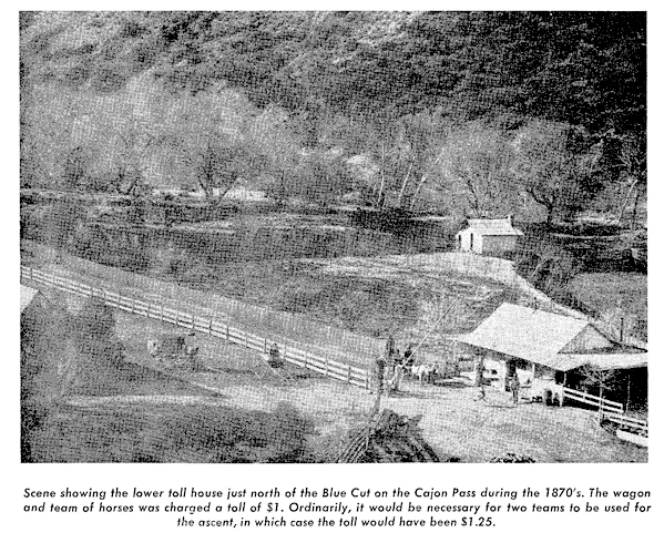 In 1861,
John Brown, Sr.,
built a
toll road from Devore to the Cajon
Pass Summit under a state franchise
good for 20 years. Tolls ranged from
3 cents per head of sheep to $1 for a
wagon and pair of animals. The lower
toll house was located at the
Blue Cut,
which marks the crossing of the pass
by the great
San Andreas Fault. The
frequent washouts that plagued the
road can be appreciated by modern
maintenance men, but we wonder
how our resourceful crews would
respond to a repetition of the Indian
attacks occurring in the early days
of the road.
In 1861,
John Brown, Sr.,
built a
toll road from Devore to the Cajon
Pass Summit under a state franchise
good for 20 years. Tolls ranged from
3 cents per head of sheep to $1 for a
wagon and pair of animals. The lower
toll house was located at the
Blue Cut,
which marks the crossing of the pass
by the great
San Andreas Fault. The
frequent washouts that plagued the
road can be appreciated by modern
maintenance men, but we wonder
how our resourceful crews would
respond to a repetition of the Indian
attacks occurring in the early days
of the road.
Railroads Compete
At about the time that the franchise on Brown's Turnpike expired and it became a county road, the railroads were engaged in a struggle to put tracks through the pass. The Los Angeles and Independence Railroad fought off Southern Pacific forces with gun play on the West Cajon, thought at that time to be the only practical route over the pass. The Southern Pacific later bought the right to build through the Cajon when it took over the bankrupt Los Angeles and Independence Railroad, with the intention to extend its San Joaquin Valley Line to the east by way of Tehachapi, Cajon, and San Gorgonio Passes, by-passing Los Angeles completely. Meanwhile, Santa Fe officials were informed of the lower pass through the East Cajon and under the name "California Southern Extension Railway," tracks were laid from San Bernardino to Barstow, causing the Southern Pacific to run its line to Los Angeles.When descending the pass today in a matter of a few minutes seated in comfort in automobile or train, it is difficult to realize the hardships of but a few years ago when it was necessary to dismantle wagons and lower them by ropes at the Narrows in the East Cajon.
Two Million Dollar Contract
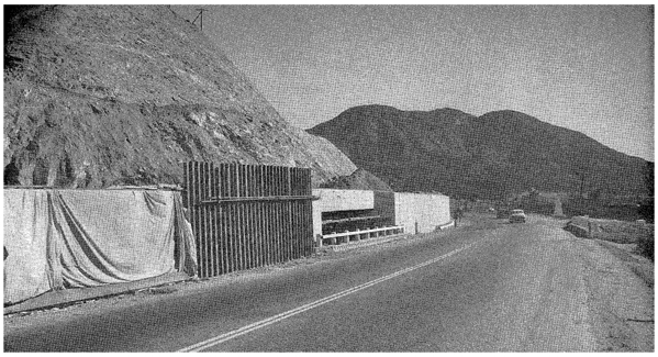
The highway contract now being completed by Fredericksen & Kasler at a cost in excess of $2,100,000 is the southerly 9.3 miles of the pass between Devore and Gish Underpass about four miles south of the summit. About half of the old two lanes built in 1932 have been converted to use for one-way traffic, with two additional lanes constructed for traffic in the opposite direction. Four new lanes of pavement have been constructed for about five miles.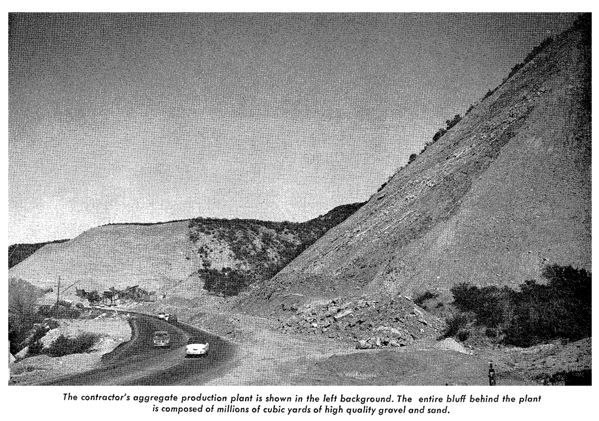
Resident Engineer J. B. MacDonald reports that the immense sand and gravel deposit near Cleghorn Creek designated in the Special Provisions as the source for base material proved to be ideal not only for the base but for mineral aggregate ire plant-mixed surfacing. R-values for the base material ranged from 76-81. No cement was used. Stability of the plant-mixed surfacing with 150-200 penetration paving asphalt was usually about 40.
Slides Cause Trouble
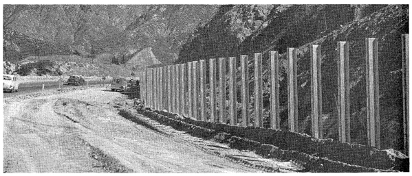
Because of previous experience at the Blue Cut, present construction tivas around the critical area. It was years after the first big cut was made here before the slopes stabilized. Initial construction at this location in 1931-1932 `vas during a severe winter and an enormous slide occurred involving 100,000 cubic yards, completely blocking the new road, as well as the existing one. It became necessary to bridge Cajon Creek temporarily and route traffic over an old trail through a cattlepass under the railroad on the opposite side of the canyon and on for two miles to Cajon Station to a connection with the existing road. About 1937, a rock wall was built to catch rolling boulders and minor slides off the Blue Cut. Intermittently, it was necessary to remove the accumulation behind the wall to provide storage for the continuing fall of debris from the unstable slide material.
Eventually, the slopes stabilized and the rock wall was removed to provide room for the four-lane section. being constructed under this contract. The cut itself was not disturbed, but to provide safety from possible rolling material from the high bank of unpredictable gouge material, a wire mesh fence fastened to 10-inch wide flange 25-pound steel columns was constructed at the toe of the slope.
Three Transcontinental Highways
Three transcontinental highways use the historic gateway serving the ever increasing traffic to and from Southern California. U. S. 395 leads from San Diego through the Cajon Pass to the Canadian border by way of Reno, Nevada, and Spokane, Washington. U. S. 91 utilizes the pass in carrying traffic from Long Beach to Las Vegas, Nevada, Salt Lake City, Utah, and Pocatello, Idaho. U. S. 66 also traverses the Cajon on its way to Chicago through Needles and Oklahoma City.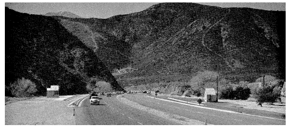
With steep grades and limited sight distance existing on most of the highway through the pass, the improvement is a great boon to the 7,500 vehicles using the road each day. About 10 percent of the traffic consists of trucks, most of which are of the multiple-axle long-haul type.
Plans are complete for the next project to extend from Gish Underpass to 1.4 miles north of Cajon Summit, a length of 5.8 miles. Plans are rapidly being developed to extend the four-lane expressway from the summit to Victorville on the Mojave Desert. Construction dates are as yet indefinite and will depend on available financing.
The assistance of the San Bernardino Sun and its Historical Editor, L. Burr Belden, is gratefully acknowledged in the preparation of this article.
CALIFORNIA HIGHWAYS AND PUBLIC WORKS
Official Journal of the Division of Highways,
Department of Public, Works, State of California
Vol. 32 - May/Jun 1953