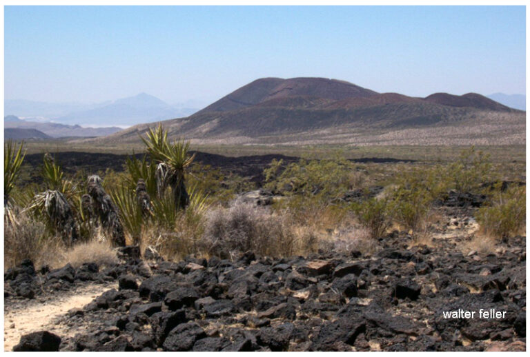
Amboy Crater is a remarkable natural feature in the Mojave Desert, offering visitors a unique opportunity to explore a dormant volcanic cinder cone and its surrounding landscape. Here’s an expanded look at what makes Amboy Crater a popular attraction:
Geological Significance
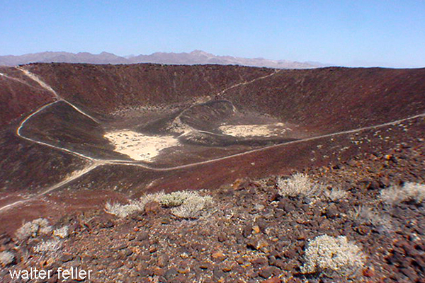
Formation: Amboy Crater is a cinder cone volcano that formed during an eruption approximately 79,000 years ago. The eruption produced the cone and extensive lava fields that stretch across the desert floor.
Volcanic Structure: The crater stands about 250 feet above the surrounding landscape and has a diameter of about 1,500 feet—the crater’s interior features a flat floor and a breached rim, indicative of past volcanic activity.
Attractions and Activities
Hiking to the Crater:
Trail Information: The hike to the summit of Amboy Crater is a moderately challenging trek of about 3 miles round trip. The trailhead is equipped with interpretive signs that provide information about the volcanic history and the local ecology.
Trail Experience: The trail leads through lava fields and desert terrain, offering a chance to see various volcanic features up close. The ascent to the crater rim provides stunning views of the surrounding desert.
Exploring the Crater:
Crater Interior: Once at the top, hikers can descend into the crater’s interior, which features a flat floor covered with volcanic ash and small rocks. It’s a unique landscape that feels almost otherworldly.
Scenic Views: The crater’s rim offers panoramic views of the Mojave Desert, including the vast lava fields and distant mountain ranges. The view is particularly striking at sunrise and sunset.
Wildlife and Flora:
Desert Plants: The area around Amboy Crater is home to various desert plants, including creosote bushes, cacti, and wildflowers. During spring, the landscape can be dotted with colorful blooms.
Wildlife: Visitors might spot desert wildlife like lizards, snakes, and birds. Despite the harsh conditions, the area’s natural habitat supports a diverse ecosystem.
Photography Opportunities:
Landscape Photography: The stark contrast between the black lava fields and the sandy desert creates dramatic photo opportunities. The crater’s unique geological features make it a favorite subject for photographers.
Astrophotography: Amboy Crater’s remote location and lack of light pollution make It an excellent spot for stargazing and astrophotography. The clear desert skies provide breathtaking views of the night sky.
Visitor Information
Location and Access: Amboy Crater is located off historic Route 66, near the town of Amboy. The site is accessible via a well-maintained dirt road and a parking area at the trailhead.
Facilities: The trailhead features shaded picnic tables, informational kiosks, and restroom facilities. There is also a viewing platform for those who prefer not to hike but still want to enjoy the scenery.
Historical and Cultural Context
Route 66: Amboy Crater is situated along the iconic Route 66, adding a layer of historical significance. The nearby town of Amboy and the famous Roy’s Motel and Café provide a nostalgic glimpse into the heyday of America’s Mother Road.
Cultural Significance: The crater and its surroundings have been a significant landmark for indigenous peoples, early travelers, and modern explorers. It has been a navigation point and a source of fascination for centuries.
Safety and Preparation
Hiking Precautions: Due to the harsh desert environment, hikers should come prepared with plenty of water, sun protection, and appropriate footwear. The trail can be challenging, especially in hot weather.
Weather Considerations: The best times to visit are during the cooler months of fall, winter, and early spring. Summer temperatures can be extreme, making hiking hazardous.
Conservation Efforts
Protected Area: Amboy Crater is designated a National Natural Landmark, recognizing its geological significance and ensuring its protection for future generations.
Responsible Tourism: Visitors are encouraged to practice Leave No Trace principles, respecting the delicate desert environment and preserving the area’s natural beauty.
Amboy Crater offers a unique blend of geological wonder, natural beauty, and historical intrigue. Whether you’re an avid hiker, a photography enthusiast, or simply curious about the natural world, Amboy Crater provides a memorable and enriching experience in the heart of the Mojave Desert.
The Mojave Desert offers a variety of unique and exciting activities. Here are ten of the most popular places:
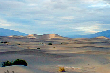
Death Valley National Park: Known for its extreme temperatures and stunning landscapes, it features attractions like Badwater Basin, the lowest point in North America, and the Mesquite Flat Sand Dunes.
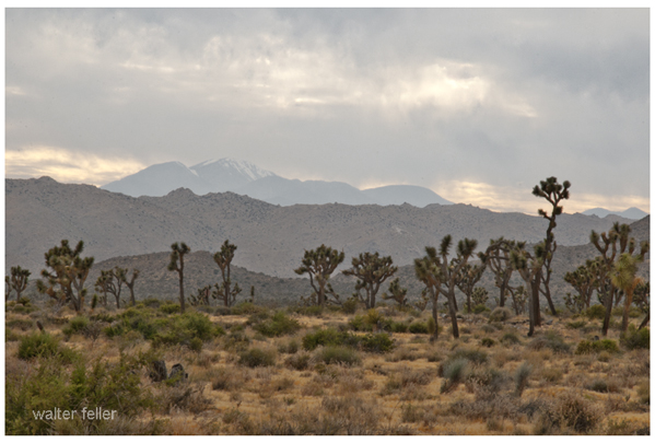
Joshua Tree National Park: Famous for its unique Joshua trees, it offers rock climbing, hiking, and stargazing opportunities amidst a surreal desert landscape. .
Mojave Road: This historic off-road trail takes you through the heart of the Mojave Desert, offering a challenging adventure with historical landmarks and diverse desert scenery.
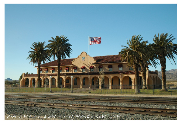
Kelso Depot Visitor Center: Located in the Mojave National Preserve, this historic train depot provides insight into the region’s rail history and is a gateway to exploring the preserve.
Mojave National Preserve: With over 1.6 million acres, the preserve offers numerous trails, including the Kelso Dunes and the Hole-in-the-Wall Rings Trail. .
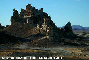
Trona Pinnacles: These unique tufa formations, formed underwater over 10,000 years ago, are popular for photography and off-road exploration. .
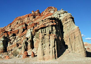
Red Rock Canyon State Park: Known for its vibrant rock formations and scenic desert cliffs, this park offers hiking, camping, and wildlife viewing opportunities. .
Amboy Crater: A dormant volcanic cinder cone, Amboy Crater provides a moderately challenging hike with rewarding views from the top. .
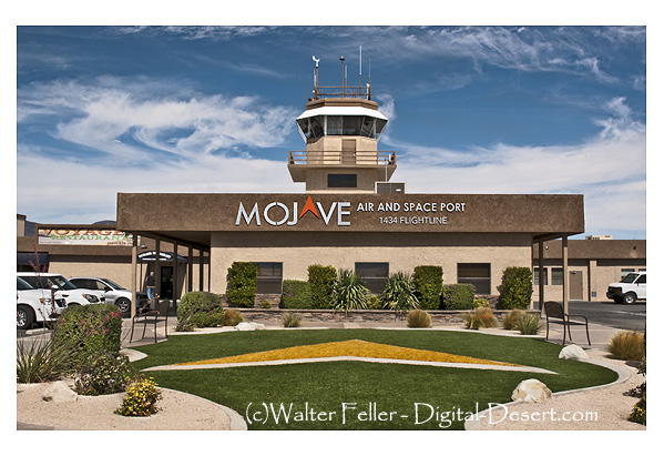
Mojave Air and Space Port: This hub for aerospace innovation offers public tours showcasing historic aircraft and cutting-edge aerospace technology. .
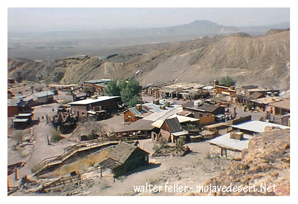
Visit Calico: A restored mining town from the Silver Rush era, Calico offers a glimpse into the past with its preserved buildings, mine tours, and reenactments. .
These activities highlight the diverse attractions and experiences the Mojave Desert offers, from natural wonders to historical sites.
The Mojave Air and Space Port, located in Mojave, California, is a unique and significant facility that plays a crucial role in the aerospace industry. Here’s an expanded look at what makes it a popular attraction and an important center for aerospace activities:
History and Significance
Establishment: Originally established in 1935 as a small rural airfield, the Mojave Air and Space Port has become a major center for aerospace research and development.
Spaceport License: In 2004, it became the first facility in the United States to be licensed as a spaceport, allowing it to conduct spaceflight activities.
Key Features and Attractions
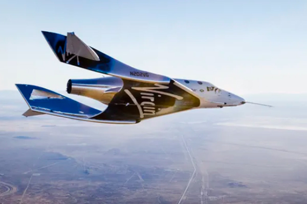
Virgin Galactic’s second SpaceShipTwo vehicle, VSS Unity, soars on its first-ever glide flight on Dec. 3, 2016. (Image credit: Virgin Galactic)
Aerospace Innovation and Companies:
Scaled Composites: the first privately funded spacecraft to reach space, is known for developing innovative aircraft, including SpaceShipOne.
Virgin Galactic: Developing commercial spaceflight services with its SpaceShipTwo spacecraft, aiming to offer suborbital space tourism.
Masten Space Systems: Working on vertical takeoff, landing rockets, and lunar lander technology.
Public Tours and Educational Opportunities:
Guided Tours: The Mojave Air and Space Port offers guided tours that provide insights into the operations of various aerospace companies, the facility’s history, and ongoing projects.
Visitor Center: This center features exhibits on the history of aviation and space exploration, including models and displays of historic and modern aircraft and spacecraft.
Aircraft Storage and Boneyard:
Aircraft Boneyard: The air and spaceport is home to a large aircraft boneyard where retired commercial and military aircraft are stored, maintained, or dismantled for parts. This is a fascinating area for aviation enthusiasts to see a variety of aircraft up close.
Flight Testing and Demonstrations:
Test Flights: The air and spaceport is a premier location for flight testing, with companies conducting regular test flights of new aircraft and spacecraft. Visitors can often witness these test flights, adding to the excitement of the visit.
Air Shows and Events: Periodic air and aerospace events showcase cutting-edge technology and historic aircraft, allowing the public to engage with the aerospace community.
Space Launches and Rocket Testing:
Rocket Engines: Various companies conduct rocket engine testing at the facility, and on occasion, space launches are performed, offering a rare chance to see rocket technology in action.
Experimental Spacecraft: The development and testing of experimental spacecraft, such as those by Virgin Galactic, offer a glimpse into the future of space travel.
Mojave Transportation Museum Foundation:
Historical Exhibits: Dedicated to preserving the rich history of transportation in the Mojave Desert, the museum features exhibits on aviation, railroads, and automotive history in the region.
Educational Programs: The foundation offers educational programs and events to inspire the next generation of engineers, pilots, and aerospace professionals.
Unique Aspects
Climate and Location: The Mojave Desert’s desert climate and wide-open spaces are ideal for aerospace testing and development.
Innovation Hub: The air and space port fosters a culture of innovation, attracting various aerospace companies and startups pushing the boundaries of technology.
Visitor Information
Accessibility: Located just off the main highways, the Mojave Air and Space Port is easily accessible for visitors traveling by car.
Amenities: The facility offers amenities such as a visitor center, dining options, and ample parking.
Future Developments
Expansion Plans: Ongoing expansion and development projects aim to enhance the air and space port’s capabilities, including new hangars, testing facilities, and infrastructure to support increased spaceflight activities.
Commercial Space Travel: As companies like Virgin Galactic move closer to offering commercial space travel, the Mojave Air and Space Port will continue to play a pivotal role in making space tourism a reality.
The Mojave Air and Space Port is not only a hub of aerospace innovation but also a fascinating destination for anyone interested in aviation, space exploration, and cutting-edge technology. Its combination of historical significance, active testing and development, and public accessibility make it a unique and exciting place to visit.
Calico Ghost Town is a fascinating destination that offers a glimpse into the past, specifically the boom-and-bust era of the American West. Here’s a detailed look at what makes Calico Ghost Town a popular attraction:
History of Calico Ghost Town
Founding and Boom Era: Calico was founded in 1881 during the California silver rush. At its peak, the town boasted over 500 mines and produced millions of dollars worth of silver ore.
Decline: By the mid-1890s, silver prices had plummeted, leading to the decline of mining activities. Calico was largely abandoned by the early 20th century, becoming a true ghost town.
Attractions and Activities
Mine Tours:
Maggie Mine: This is one of the few mines in Calico that is safe for tourists to enter. Visitors can take a self-guided tour to learn about the mining techniques and see the remnants of the silver extraction process.
Calico Odessa Railroad: A narrow-gauge train ride that offers a scenic tour of the town and the surrounding mining areas, providing insights into the town’s mining history.
Historical Buildings:
Lane’s General Store: Restored to its 1880s appearance, this general store offers a variety of souvenirs and historical artifacts.
Schoolhouse: A replica of the original schoolhouse where children of miners once studied. It now serves as a museum displaying educational artifacts from the era.
Lil’s Saloon: A typical Old West saloon where visitors can enjoy refreshments and imagine the lively atmosphere of Calico during its heyday.
Living History and Reenactments:
Gunfight Shows: Regularly scheduled reenactments of gunfights and skirmishes typical of the Wild West, performed by actors in period costumes.
Ghost Tours: Evening tours that delve into the spookier side of Calico’s history, sharing ghost stories and legends associated with the town.
Shops and Craft Demonstrations:
Blacksmith Shop: Demonstrations of traditional blacksmithing techniques, with the opportunity to purchase handmade metal items.
Pottery and Leather Shops: Artisans demonstrate their crafts, offering unique, handmade goods for sale.
Special Events:
Calico Days: An annual festival celebrating the town’s history with parades, live music, and old-fashioned games.
Ghost Haunt: A Halloween-themed event featuring haunted attractions and spooky activities for all ages.
Natural Surroundings
Hiking Trails: Various trails around Calico offer hiking opportunities with views of the desert landscape and remnants of old mining operations.
Desert Flora and Fauna: The area is home to unique desert plants and wildlife, complementing the historical attractions.
Visitor Information
Accessibility: Calico Ghost Town is easily accessible from major highways and offers ample parking for visitors.
Facilities: The site includes picnic areas, restrooms, and camping facilities for those wishing to extend their visit.
Significance
Educational Value: Calico Ghost Town serves as an important educational resource, teaching visitors about the history of mining, the lifestyle of early settlers, and the economic forces that shaped the American West.
Preservation: The town has been designated a California Historical Landmark and is maintained by the San Bernardino County Regional Parks system, ensuring its preservation for future generations.
Calico Ghost Town offers a unique blend of history, entertainment, and education, making it a must-visit destination for anyone interested in the rich heritage of the Mojave Desert and the American West.
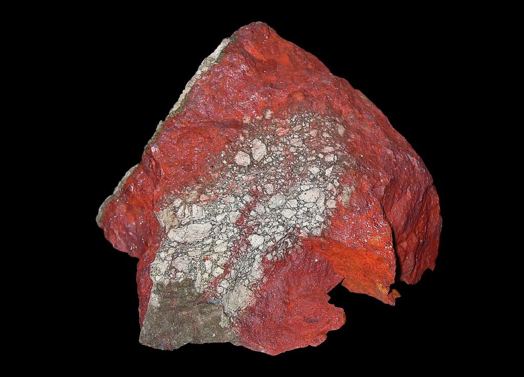
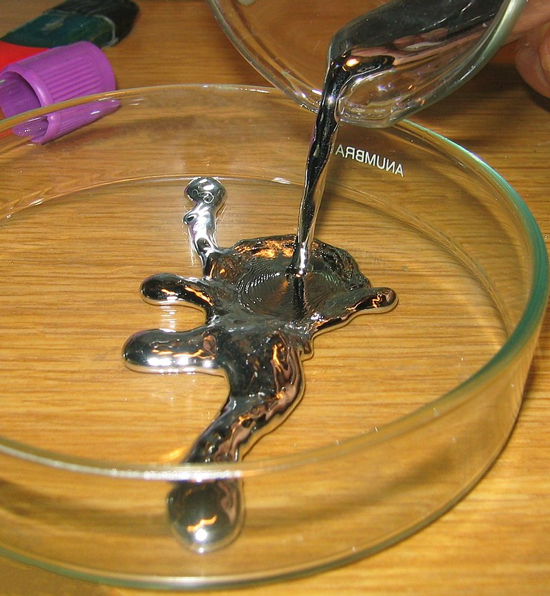
Mercury is a naturally occurring element that is found in the Earth’s crust, and it is extracted from cinnabar ore. The process of obtaining mercury from cinnabar involves several steps:
By H. Zell – Own work, CC BY-SA 3.0, Cinnabar. (2024, April 11). In Wikipedia. https://en.wikipedia.org/wiki/Cinnabar
Mining: Mercury is primarily obtained from cinnabar ore, which contains mercury sulfide (HgS). The cinnabar ore is mined from deposits found in the Earth.
Crushing and Grinding: The mined cinnabar ore is crushed and ground to liberate the mercury sulfide from the surrounding rock.
Roasting: The crushed ore is then heated in a furnace to a temperature of about 500 to 600 degrees Celsius (932 to 1112 degrees Fahrenheit) in the presence of oxygen. This process, called roasting, causes the mercury sulfide to decompose into mercury vapor and sulfur dioxide gas: HgS+O2→Hg+SO2
Condensation: The mercury vapor is then cooled and condensed into liquid mercury. This is typically done by passing the vapor through a series of condensers where it cools and changes back into a liquid state.
Purification: The liquid mercury is collected and further purified to remove impurities. This can be done through distillation, where the mercury is heated to vaporize it again and then condensed to obtain pure mercury.
The resulting liquid mercury is then stored in flasks or containers and used for various industrial and scientific applications.
By Bionerd – Own work, CC BY 3.0, Mercury (element). (2024, May 16). In Wikipedia. https://en.wikipedia.org/wiki/Mercury_(element)
Cinnabar (mercury sulfide, HgS) is toxic. The primary concern with cinnabar is its mercury content. Here are some key points about its toxicity:
Mercury Content: Cinnabar contains mercury, which is a highly toxic element. Mercury can exist in several forms, each with different levels of toxicity and ways of causing harm. The toxicity primarily depends on the form and the route of exposure.
Inhalation Hazards: When cinnabar is heated or processed, it can release mercury vapor. Mercury vapor inhalation is particularly dangerous as it can cause severe neurological and systemic health problems.
Skin Contact and Ingestion: While elemental mercury is less easily absorbed through the skin, compounds like mercury sulfide in cinnabar can be harmful if ingested or if particles are inhaled. Chronic exposure can lead to mercury poisoning, which can affect the kidneys, nervous system, and other organs.
Chronic Exposure: Long-term exposure to mercury, even in small amounts, can lead to mercury poisoning, with symptoms including tremors, memory problems, mood swings, and cognitive impairment.
Environmental Impact: Mercury from cinnabar mining and processing can also contaminate the environment, leading to bioaccumulation in the food chain and affecting wildlife and human health.
Due to these risks, handling cinnabar and processing mercury require strict safety protocols to protect workers and the environment. Proper ventilation, protective equipment, and environmental controls are essential to minimize exposure and prevent mercury poisoning.
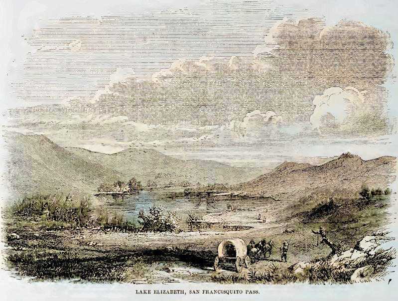
Elizabeth Lake, located in the Sierra Pelona Mountains of Los Angeles County, California, is enveloped in folklore and legend, making it one of the most intriguing spots in the Mojave Desert region. The most prominent legend associated with Elizabeth Lake involves mysterious and terrifying creatures.
The Myth of the Monster
According to local lore, Elizabeth Lake is home to a monster described as a massive, dragon-like creature. This legend dates back to the early Spanish settlers and the indigenous people before them. The beast, often called the “Elizabeth Lake Monster,” has wings, a long tail, and a fearsome appearance. Accounts of sightings have persisted through the centuries, often varying in detail but maintaining the core elements of a menacing beast.
Historical Accounts
In the mid-19th century, stories of the monster were popular among ranchers and settlers. Some tales suggest that the creature could fly, and its wingspan was so large that it cast a shadow over the entire lake. These stories contributed to the lake’s reputation as a place to be feared.
Explanations and Speculation
Several theories attempt to explain the legend of Elizabeth Lake. Some suggest that the stories originated from large birds or other wildlife sightings. Others believe that the lake’s mysterious aura and the eerie atmosphere could have fueled imaginations, leading to the creation of the monster legend.
Modern Interest
Today, Elizabeth Lake remains a site of curiosity for locals and visitors. While no concrete evidence of the monster’s existence has ever been found, the legend remains part of the area’s cultural heritage. The picturesque lake attracts nature enthusiasts and those intrigued by its storied past.
Conclusion
The Legend of Elizabeth Lake is a captivating part of Mojave Desert folklore. Whether rooted in real events or purely a product of imagination, the stories of the Elizabeth Lake Monster add a layer of mystique to this serene and beautiful spot in California.
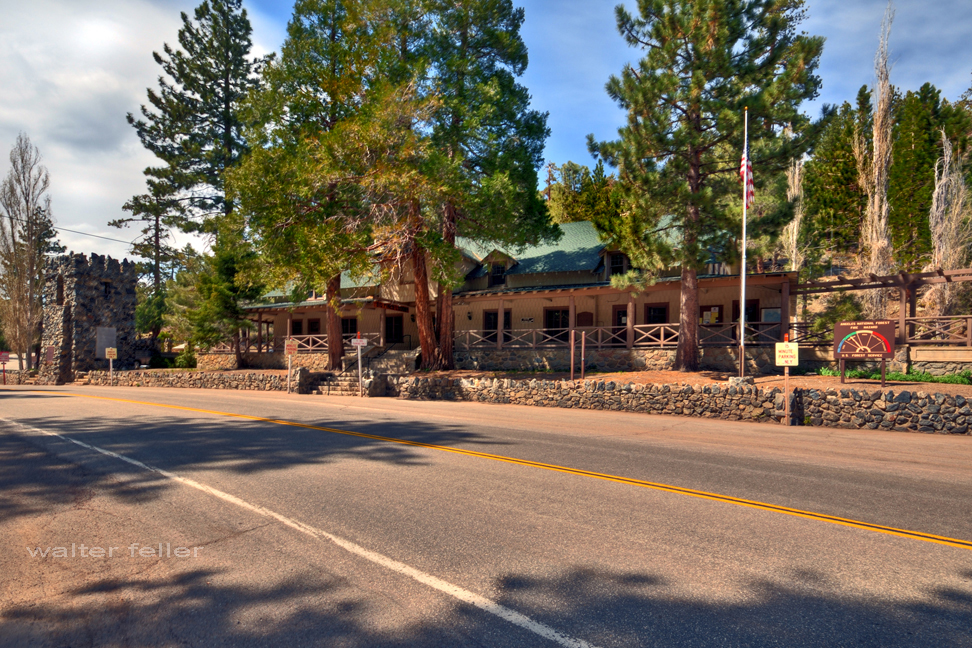
Swarthout Lodge, located in the Big Pines Recreation Area of the Angeles National Forest, has a rich history tied to developing recreational facilities in Southern California. Here’s a detailed overview of its history:
Early Beginnings
1924: The Los Angeles County Board of Supervisors established the Big Pines Recreation Area as a mountain resort to promote public recreation. This was part of a broader effort to make the natural beauty of the San Gabriel Mountains accessible to the public.
Initial Development: The area quickly became popular for winter sports and summer activities. Facilities such as lodges, cabins, and a ski jump were constructed to accommodate visitors.
Swarthout Lodge
Construction: Swarthout Lodge was one of the central buildings in the Big Pines Recreation Area. Named after H. L. Swarthout, the lodge served as a visitor hub.
Architecture: The lodge was designed in a rustic style typical of mountain resorts of the era. Its focus was on blending into the natural surroundings while providing essential amenities for guests.
Role in Recreation
Winter Sports: The lodge played a significant role in promoting winter sports, particularly skiing. Big Pines became a premier destination for Southern Californians seeking snow sports, and Swarthout Lodge was at the heart of this activity.
Summer Activities: During the summer, the lodge served as a base for hiking, fishing, and other outdoor activities. Its location in the Angeles National Forest provided easy access to numerous trails and scenic spots.
Decline and Changes
Mid-20th Century: As recreational trends changed and other mountain resorts developed, the popularity of Big Pines and Swarthout Lodge began to decline. Additionally, natural disasters like fires and floods affected the area, leading to periods of reconstruction and change.
Transition: Over the years, the lodge’s management and use evolved. Parts of the original facilities were repurposed or fell into disrepair, reflecting broader changes in public recreation and forest management policies.
Legacy and Current Status
Preservation Efforts: In recent years, efforts have been made to preserve and restore historic structures within the Big Pines Recreation Area, including Swarthout Lodge. These efforts aim to maintain the historical significance and promote the area’s rich heritage.
Modern Use: Today, the Big Pines Recreation Area offers recreational opportunities, although the focus has shifted to more sustainable and environmentally conscious practices. Swarthout Lodge’s history remains a testament to the early efforts to make natural landscapes accessible for public enjoyment.
With its historical significance and role in the development of outdoor recreation in Southern California, Swarthout Lodge remains an important part of the heritage and history of the Angeles National Forest.
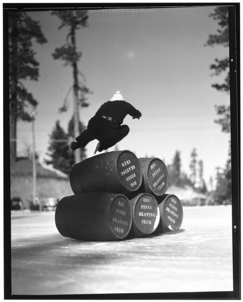
Photograph of ice skate jumping at Big Pines Recreation Camp, 1929. Five barrels labeled “Big Pines Skating Club” are stacked on their sides on the ice at the center. A skater in dark clothing and a lightly-colored hat is mid-jump over the barrels. Tall evergreen trees stand in the background.;
“In 1923, Los Angeles County established a major recreational facility at Big Pines, an all-year resort that included winter and summer sports. Big Pines Recreation Camp (elevation 6,862 feet) had cabins, a dining room, a fountain, and a store. Many buildings still stand (notably one of the two stone towers that once supported a pedestrian overpass across Highway 2, west of Wrightwood). Now administered by the U.S. Forest Service, Big Pines is a popular recreation area encompassing three ski resorts, several campgrounds, and Jackson Lake.”
Title: Ice skate jumping at Big Pines Recreation Camp, 1929 Date: 1929 Collection: California Historical Society Collection, 1860-1960 Owning Institution: California Historical Society Source: Calisphere Date of access: May 19 2024 16:16 Permalink: https://calisphere.org/item/82e13683baac344604588a7655825d43/
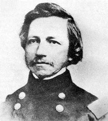
The Whipple 35th Parallel Railroad Survey, led by Lieutenant Amiel Weeks Whipple in 1853, was a pivotal expedition to explore a potential transcontinental railroad route along the 35th parallel from Fort Smith, Arkansas, to Los Angeles, California. Commissioned by Secretary of War Jefferson Davis, the survey aimed to assess the feasibility of the railroad, gather scientific data, and document interactions with Native American tribes, significantly contributing to the understanding and development of the American West.
Excerpt from – Harper’s New Monthly Magazine The Tribes of the Thirty-Fifth Parallel September 1858 VOL. XVII.–No. 100
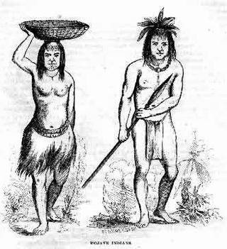
Mohaves
Leaving the beautiful valley of the Chemehuevis, we presently find our friends among the shrewd, sprightly, and hospitable Mojaves. On the 25th of February, they were honored by a visit of ceremony from a pompous old chief of the Mojaves, who presented credentials from Major Heintzelman.–The Major wrote that the bearer, Captain Francisco, had visited Fort Yuma, with a party of warriors, while on an expedition against the Cocopas, and that he had professed friendship; but Americans were advised not to trust him.
The parade and ceremony with which the visit was set off were not, in this instance, altogether vain and idle, for without them that august personage, Captain Francisco, might easily have been mistaken for the veriest[sic] beggar of his tribe. He was old, shriveled, ugly, and naked-but for a strip of dirty cloth suspended by a cord from his loins and an old black hat, band-less and torn, drawn down to his eyes. But his credentials were satisfactory, and he was received with all the honors and installed in a stately manner on a blanket. The object of the expedition was explained to him, and he cordially promised aid and comfort. A few trinkets, some tobacco, and red blankets cut into narrow strips were then presented for distribution among the warriors. The chief would accept nothing for himself, so the council was dissolved. The Mojave chiefs look upon foreign gifts in a national light and accept them only in the name of the people.
Savedra counted six hundred Indians in camp, of whom probably half had brought bags of meal or baskets of corn for sale. The market was opened, and all were crowding, eager to be the first at the stand, amidst shouts, laughter, and a confusion of tongues-English, Spanish, and Indian.
When the trading was concluded, the Mojave people sauntered about the camp in picturesque and merry groups, making the air ring with peals of laughter. Some of the young men selected a level spot, forty paces in length, for a play-ground, and amused themselves with their favorite game of hoop-and-poles. The hoop is six inches in diameter, and made of elastic cord; the poles are straight, and about fifteen feet in length. Rolling the hoop from one end of the course toward the other, two of the players chase it half-way, and at the same time throw their poles. He who succeeds in piercing the hoop wins the game.
Target-firing and archery were then practiced–the exploring party using rifles and Colt’s pistols, and the Indians shooting arrows.
The fire-arms were triumphant; and at last an old Mojave, mortified at the discomfiture of his people, ran in a pet and tore down the target. Notwithstanding the unity of language, the family resemblance, and amity between the Cuchans and Mojaves, a jealousy, similar to that observed among Pimas and Maricopas, continually disturbs their friendship. A squaw detected her little son in the act of concealing a trinket that he fancied. She snatched the bauble from him with a blow and a taunt, saying, “Oh, you Cuchan!” Some one inquired if he belonged to that tribe. “Oh no,” she replied ” he is a Mojave, but behaves like a Cuchan, whose trade is stealing !” Nevertheless, the Cuchans are welcomed by the Mojaves wherever they go.
These Indians are probably in as wild a state of nature as any tribe on American territory.
They have not had sufficient intercourse with any civilized people to acquire a knowledge of their language or their vices. It was said that no white party had ever before passed through their country without encountering hostility.
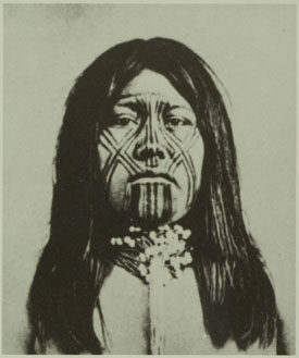
Nevertheless they appear intelligent, and to have naturally amiable dispositions. The men are tall, erect, and well-proportioned; their features inclined to European regularity; their eyes large, shaded by long lashes, and surrounded by circles of blue pigment, that add to their apparent size. The apron, or breech-cloth, for men, and a short petticoat, made of strips of the inner bark of cotton-wood, for women, are the only articles of dress deemed indispensable; but many of the females have long robes, or cloaks, of fur. The young girls wear heads.
When married, their chins are tattooed with vertical blue lines, and they wear a necklace with a single sea-shell in front, curiously wrought.
Those shells are very ancient, and esteemed of great value.
From time to time they rode into the camp, mounted on spirited horses; their bodies and limbs painted and oiled, so as to present the appearance of highly-polished mahogany. The dandies paint their faces perfectly black. Warriors add a streak of red across the forehead nose, and chin. Their ornaments consist of leathern bracelets, adorned with bright buttons, and worn on the left arm; a kind of tunic, made of buckskin fringe, hanging from the shoulders; beautiful eagles’ feathers, called “sormeh”–sometimes white, sometimes of a crimson tint-tied to a lock of hair, and floating from the top of the head; and, finally, strings of wampum, made of circular pieces of shell, with holes in the centre, by which they are strung, often to the length of several yards, and worn in coils about the neck.
These shell beads, which they call “pook,” are their substitute for money, and the wealth of an individual is estimated by the “pook” cash he possesses. Among the Cuchans, in 1852, a foot of “pook” was equal in value to a horse; and divisions to that amount are made by the insertion of blue stones, such as by Coronado and Alargon were called “turkoises,” [turquoise] and are now found among ancient Indian ruins.
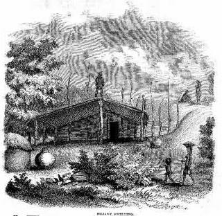
The Mojave rancherias are surrounded by granaries filled with corn, mesquite beans, and tortillas. The houses are constructed with an eye to durability and warmth. They are built upon sandy soil, and are thirty or forty feet square; the sides, about two feet thick, of wicker-work and straw; the roofs matched, covered with earth, and supported by a dozen cottonwood posts. Along the interior walls are ranged large earthen pots, filled with stores of corn, beans, and flour, for daily use. In front is a wide shed, a sort of piazza, nearly as large as the house itself. Here they find shelter from rain and sun. Within, around a small fire in the centre, they sleep. But their favorite resort seems to be the roof, where could usually be counted from twenty to thirty persons, all apparently at home. Near the houses were a great number of cylindrical structures, with conical roofs, quite skillfully made of osiers; these were the granaries, alluded to above, for their surplus stores of corn and mesquite.
As the explorers passed these rancherias, the women and children watched them from the house-tops; and the young men, for the moment, suspended their sport with hoop and poles. At first only a few of the villagers seemed inclined to follow them, but at length their little train swelled to an army a mile in length.
On the 27th of February, being favored with a clear and calm morning, they hastened to take advantage of it to cross the river; but the rapid current and the long ropes upset their ” gondola” in mid-stream. The Mojaves, who are capital swimmers, plunged in and helped them save their property. Many had brought rafts to the spot, anticipating the disaster. These were of simple construction, being merely bundles of rushes placed side by side, and securely bound together with osiers.
But they were light and manageable, and their crews plied them with considerable dexterity.
It was night when finally the great work was accomplished-the Colorado crossed, and the camp pitched on the right bank.
Our friends had now quite exhausted their stock in trade in gifts, although large quantities of grain were yet in camp for sale. When told that their white brothers were too poor to buy, the Indians expressed no disappointment, but strolled from fire to fire, laughing, joking, curious but not meddlesome, trying, with a notable faculty of imitation, to learn the white man’s language, and to teach their own.
As long as our explorers were among them, these Mojaves were gay and happy, talking vicariously, singing, laughing. Confiding in the good intentions and kindness of the strangers, they laid aside for the time their race’s studious reserve. Tawny forms glided from one camp-fire to another, or reclined around the blaze, their bright eyes and pearly teeth glistening with animation and delight. They displayed a new phase of Indian character, bestowing an insight into the domestic amusements which are probably popular at their own firesides: mingling among the soldiers and Mexicans, they engaged them in games and puzzles with strings, and some of their inventions in this line were quite curious.
No doubt these simple people were really pleased with the first dawning light of civilization.
They feel the want of comfortable clothing, and appreciate some of the advantages of trade. There is no doubt that, before many years pass away, a great change will have taken place in their country. The advancing tide of emigration will sweep over it, and, unless the strong arm of Government protects them, the Mojaves will be driven to the mountains or exterminated.
When the exploring party wore about to leave, the chiefs came with an interpreter, to say that a national council had been held, in which they had approved of the plan for opening a great road through the Mojave country. They knew that on the trail usually followed by the Pai’ Utes toward California the springs were scanty, and insufficient for the train; that thus the mules might perish on the road, and the expedition fail. Therefore they had selected a good man, who knew the country well, and would send him to guide their white brothers by another route, where an abundance of water and grass would be found. They wished their white brothers to report favorably of their conduct to the Great Chief at Washington, in order that he might send many more of his people to pass that way, and bring clothing and utensils to exchange for the produce of their fields.
Desiring to learn something of their notions regarding the Deity, death, and a future existence, Lieutenant Whipple led an intelligent Mojave to speak upon these subjects. One stooped and drew in the sand a circle, which he said was to represent the former casa, or dwelling-place of Mat-e-vil, Creator of Earth (which was a woman) and Heaven. After speaking for some time with impressive, and yet almost unintelligible, earnestness regarding the traditions of that bright era of their race which all Indians delight in calling to remembrance, he referred again to the circle, and suiting the action to the word, added:
“This grand habitation was destroyed, the nations were dispersed, and Mat-e-vil took his departure, going eastward over the great waters. 110 promised, however, to return to his people and dwell with them forever; and the time of his coming they believe to be near at hand.”
The narrator then became enthusiastic in the anticipation of that event, which is expected to realize the Indian’s hopes of a paradise on earth. Much that he said was incomprehensible. The principal idea suggested was the identity of their Deliverer, coming from the east, with the Montezuma of the Pueblo Indians, or perhaps the Messiah of Israel; and yet the name of Montezuma seemed utterly unknown to this Indian guide. His ideas of a future existence appeared somewhat vague and undefined. The Mojaves, he said, were accustomed to burn the bodies of the dead; but they believe that an undying soul arises from the ashes of the deceased, and takes its flight, over the mountains and waters, eastward to the happy spirit-land.
Loroux says, that he has been told by a priest of California that the Colorado Indians were Aztecs, driven from Mexico at the time of the conquest of Cortez. He thinks the circle represents their ancient city, and the water spoken of refers to the surrounding lakes. This idea derives some plausibility from the fact, mentioned by Alargon, that, in his memorable expedition up the Colorado River in 1540, he met with tribes that spoke the same language as his Indian interpreters, who accompanied him from the City of Mexico, or Culiacan.
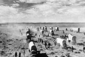
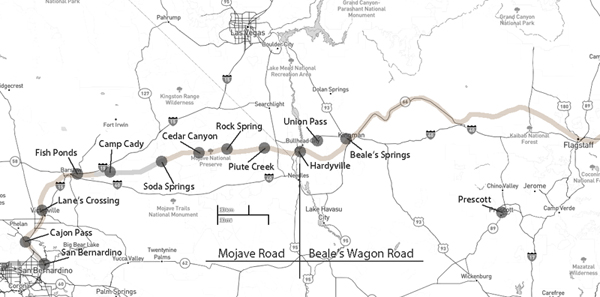
The Rose-Baley Wagon Train was a significant event in the history of American westward migration. Here is an overview of its history:
Background and Planning
The Rose-Baley Wagon Train was one of the earliest attempts to reach California via the newly built Beale Wagon Road. The expedition was organized in 1858 by two groups, one led by Leonard Rose from New Mexico and another by Dr. Joseph R. Bailey (often spelled Baley) from Iowa. Their goal was to find a shorter and safer route to California, bypassing the treacherous terrain and hostile territories commonly faced on the Oregon and Santa Fe Trails.
The Journey Begins
The two groups met in Albuquerque, New Mexico, in July 1858. They combined their resources, forming a large wagon train of about 60 to 70 wagons and over 100 people, including men, women, and children. They followed the Beale Wagon Road, which had been surveyed by Edward Fitzgerald Beale, a former naval officer and explorer.
Challenges and Conflicts
The journey was fraught with difficulties. The terrain was rugged, and the summer heat in the desert was relentless. Water sources were scarce, making sustaining the livestock and the travelers challenging.
In August 1858, the wagon train faced a significant challenge when encountering the Mojave Desert. They were attacked by a group of Native Americans, often identified as Mojave Indians, who were hostile to the encroachment on their lands. The attack resulted in the death of several members of the wagon train and significant loss of livestock.
Turning Back
After the attack, the survivors were forced to abandon their goal of reaching California via the Beale Wagon Road. They retreated to Albuquerque, where they regrouped and considered their options. The expedition’s failure was a significant setback for those hoping to establish a new route to California.
Legacy
The Rose-Baley Wagon Train is remembered as one of the early attempts to pioneer new routes to the West Coast. Despite its failure, the expedition highlighted the challenges of westward expansion and the need for more secure and reliable routes. It also underscored the tensions between settlers and Native American tribes during American history.
The Beale Wagon Road itself eventually became a significant route for future migrations, contributing to the expansion and development of the American West. The experiences of the Rose-Baley Wagon Train provided valuable lessons for subsequent expeditions and were part of the broader narrative of the westward movement in the United States.