Mohave tui Chub: The Last Native Fish of the Mojave River

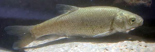
Mohave tui ChubPhoto – Joe Ferreia, California Fish & Wildlife

The Mohave tui chub (Siphateles bicolor mohavensis), formerly Gila bicolor mohavensis, is the only fish native to California’s Mojave River. It once lived throughout the river–inhabiting deep pools, sloughs, marshes, and backwaters from the Forks of the Mojave near the San Bernardino Mountains to Soda Lake near Baker. Now, it survives only in a few isolated refuges, making it one of the rarest native fishes in the American Southwest.
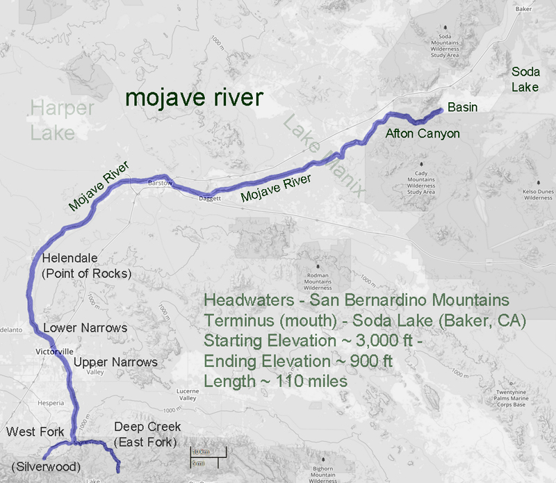
The Mojave River is unlike most North American rivers. It courses about 100 miles from the San Bernardino Mountains into the Mojave Desert, with most of its water underground. Surface flows occur only where bedrock forces groundwater to the surface, or when storms cause runoff. Despite being intermittent, the river once supported a rich aquatic ecosystem, including the Mohave tui chub.

The fish is a chunky, large-scaled minnow with a small terminal mouth, olive-brown to brassy back, and silver-white belly. Adults are usually 4 to 6 inches long; some reach 9 inches. Mohave tui chub feed on insect larvae, algae, and organic debris. Spawning runs from February to October, when females deposit thousands of adhesive eggs on aquatic plants.

For thousands of years, the species did well in the Mojave River basin. Its decline began in the early twentieth century as dams, groundwater pumping, and water diversions altered the river’s flow. Yet, habitat modification alone did not cause its disappearance.
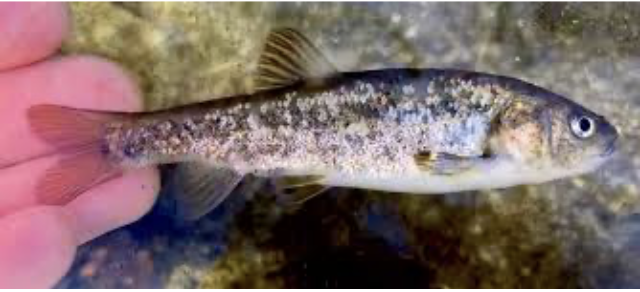
Arroyo chub (Gila orcutti) – Hank Baker

Around 1930, arroyo chub (Gila orcutti), native to coastal Southern California streams, were introduced into reservoirs in the San Bernardino Mountains. Likely released by trout anglers or accidentally during fish stocking, they spread throughout the Mojave River after major floods in March 1938.

Unlike many introduced species that compete with native wildlife, the arroyo chub threatened the Mohave tui chub by interbreeding with it. Studies by Carl Hubbs and Robert Miller documented extensive hybridization and backcrossing. Over time, the native fish was absorbed into the introduced population. By the 1960s, pure Mohave tui chubs had disappeared from the Mojave River, and by 1970, the species was effectively extirpated from its native habitat.
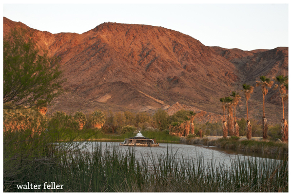
Lake Tuendae

Fortunately, a small population survived in isolated ponds at Soda Springs near the lower end of the watershed. These fish formed the foundation for all subsequent recovery efforts.

Authorities immediately recognized the species’ precarious status. The Mohave tui chub was listed as endangered under federal law in 1970, and the State of California followed in 1971. California also designated it as a Fully Protected species. In 1984, the U.S. Fish and Wildlife Service completed a recovery plan to prevent extinction and to establish secure refuge populations.

Today, genetically pure Mohave tui chubs survive in only a few places: Lake Tuendae at Zzyzx, Camp Cady Wildlife Area, MC Spring, and the Lark Seep system at China Lake. The China Lake population is regarded as the most secure. Since the mid-1990s, annual surveys there have estimated the number of fish in thousands. Water quality monitoring, invasive species control, habitat management, and vegetation removal help maintain suitable conditions.

Modern genetic studies have greatly improved the understanding of the species. Yongjiu Chen, Steve Parmenter, and Bernie May used microsatellite DNA analysis to examine surviving populations and compare them with fish from the Mojave River. Their results confirmed that refuge populations remain genetically pure Mohave tui chubs, while fish occupying the Mojave River today are pure arroyo chubs.
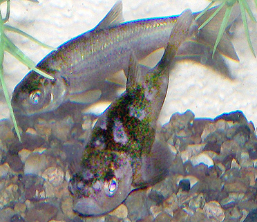
Mohave tui Chub – Arroyo Chub – photo Walter Feller

The study revealed key differences among populations. Lake Tuendae and China Lake have high genetic diversity and are genetically similar. Camp Cady has lower diversity because it was founded by only 10 fish. MC Spring shows the lowest diversity, likely due to long isolation and genetic change. The researchers recommended boosting gene flow among populations and creating new ones from the most diverse sites.

While the Mohave tui chub survived, the Mojave River itself continued to change. By 2002, at least twenty-two non-native fish species had entered the watershed. Introduced species dominated fish communities in the middle and lower Mojave River. Researchers documented six exotic species in their study reaches and found evidence of continued hybridization among non-native fishes. In some locations, other introduced species displaced even the arroyo chub.

Many scientists concluded restoration of Mohave tui chub to its historic range would be very difficult. The river’s ecology has been fundamentally changed by invasive species, water development, habitat modification, and altered hydrology. While some reintroductions might be possible within controlled settings, restoring the species throughout the Mojave River now appears unlikely.

Despite these challenges, important habitat remains. One example is the Transition Zone of the Mojave River, where perennial surface water supports a fifteen-mile corridor of cottonwood and willow forest. Conservation measures have protected portions of this habitat, including the 1,647-acre Palisades Ranch. The property contains approximately 3.5 miles of Mojave River frontage and hundreds of acres of riparian forest, supporting a remarkable diversity of wildlife.

Species benefiting from the protection of the river corridor include the southwestern willow flycatcher, least Bell’s vireo, western yellow-billed cuckoo, Mojave River vole, southwestern pond turtle, arroyo toad, desert tortoise, Mohave ground squirrel, burrowing owl, and Mohave shoulderband snail. The area also contains habitat that could support Mohave tui chub if biological and hydrological obstacles are overcome.

The story of the Mohave tui chub is both a conservation success and a cautionary narrative. The species disappeared from the river where it evolved, not primarily because of direct predation or habitat destruction, but because it was replaced by genetic introgression from an introduced relative. Yet biologists, land managers, and conservation agencies worked together to save the fish from extinction.

Now, the Mohave tui chub is a living remnant of the earliest Mojave River ecosystem. Its survival depends on protected refuges, careful genetic management, and protection of remaining river stretches. As the only fish native to the Mojave River basin, it is a key symbol of the desert’s natural heritage.

Mohave tui Chub

Sensitive Fish Species

Lake Tuendae

Mojave River

Mojave Desert History:

Who Is in Charge?

No single government, tribe, agency, or company controls the Mojave Desert. That is the first rule for understanding its history. The Mojave is not one jurisdiction. It is an area with many overlapping authorities. It is older than the borders now drawn. It is still managed piece by piece: by federal land agencies, tribal nations, state governments, county supervisors, city councils, military commands, water districts, railroads, utilities, conservation laws, mining claims, private property, and custom.

Before American maps and agencies, Native peoples held authority over the region. Their homelands, trails, springs, food-gathering areas, trade routes, and river crossings shaped the land. This was not “ownership” in the later courthouse sense; instead, it meant use, memory, obligation, defense, kinship, and sacred geography. The Mojave people controlled key parts of the Colorado River. Paiute, Chemehuevi, Serrano, Cahuilla, Kawaiisu, Timbisha Shoshone, and others were tied to desert and mountain margins. Authority followed water, trails, seasonal movement, and social ties.

Spanish and Mexican authority followed, coming lightly and unevenly. The Mojave was crossed, described, feared, and sometimes claimed. It was not closely governed. Missions, ranchos, military parties, and traders affected the edges and corridors more than the interior. The desert was difficult to occupy in the usual colonial way. Water was scarce. Distances were great. Native people still controlled much of the practical geography.

After the United States took California and the Southwest, authority became more formal but not necessarily more complete. Surveyors, soldiers, miners, freighters, railroad companies, and county officials imposed new systems of control. Military posts guarded roads and river crossings. Mining districts drafted local rules before the full government arrived. Stage and wagon roads made certain corridors important. Counties claimed jurisdiction, but their reach was often thin.

The arrival of the railroad changed the balance of power. The Atlantic and Pacific Railroad, later tied to the Santa Fe system, crossed the Mojave. Authority gathered around depots, water stops, sidings, land grants, and townsites. Places like Daggett, Barstow, Needles, Kelso, and Mojave developed. Transportation created order in a land that had previously resisted centralized control. The railroad did not govern the whole desert. However, it controlled movement, freight, settlement patterns, and economic opportunity.

Mining created another layer. Silver, gold, borax, copper, iron, salt, and other minerals brought camps, claims, mills, roads, and speculation. In many districts, authority came from miners’ meetings, claim notices, local custom, and whoever could pay for extraction and hauling. Over time, state and federal law provided the legal framework. On the ground, the desert was ruled by remoteness, money, water, and endurance.

Homesteading added another layer to authority. The government encouraged settlement through land laws. Much of the Mojave, however, was marginal for farming. Some settlers proved up claims. Some built cabins. Some failed. Some left behind the jackrabbit homestead landscape. Authority here was paper-based: legal descriptions, patents, assessment rolls, roads, school districts, and county maps. But the land itself often had the final word.

In the 20th century, the federal government became the main land authority. National parks, military bases, grazing districts, wildlife refuges, reclamation projects, and later BLM management made much of the Mojave public land. World War II and the Cold War expanded the military presence. Fort Irwin, China Lake, Edwards Air Force Base, Marine Corps bases, and training ranges made the desert a national defense site.

At the same time, water and power authorities became decisive. As a result, projects like the Hoover Dam, the Colorado River system, aqueducts, transmission lines, pipelines, and later solar and wind initiatives connected the Mojave to cities across the Southwest. In this phase, the desert was governed by both land ownership and infrastructure.

Later, the conservation era changed the question of authority again. Laws and designations like the 1964 Wilderness Act, the 1976 Federal Land Policy and Management Act, the California Desert Conservation Area, and the 1994 California Desert Protection Act redefined much of the Mojave as habitat, wilderness, cultural landscape, and public trust. Groups such as the National Park Service, BLM, Fish and Wildlife, state agencies, county governments, tribes, miners, ranchers, off-road users, utilities, conservation groups, and local residents all joined the debate.

Today, much of the California desert is managed by the Bureau of Land Management. Other major areas are under the National Park Service, such as Mojave National Preserve, Joshua Tree National Park, and Death Valley National Park. The military is also a major landholder and decision-maker. Tribal authority is increasingly recognized through consultation, co-stewardship, and co-management, though this is not always done equally or adequately. Counties regulate land use in private and unincorporated areas. Cities govern their own townsites. Water districts, utilities, mining companies, conservation groups, and private owners all hold some authority.

Also, who is in charge?

The best answer is: it depends on where you are, what resource is at issue, and what kind of authority you mean. A ranger can control a campground. A county may control the zoning. A sheriff can enforce local law. The BLM can manage grazing, recreation, mining access, or conservation on public land. The Park Service may regulate activity within a preserve or park. A tribe may exercise cultural, historical, legal, and, sometimes, land-management authority. The military can close an entire landscape. A water district can decide the fate of an aquifer. A railway or utility may control a corridor. A private owner may hold title to a desert square surrounded by public land.

That is the Mojave’s pattern: not centralized command, but layered jurisdiction. The desert has always been negotiated valley by valley, spring by spring, road by road. Its history is people trying to cross it, use it, protect it, extract from it, defend it, name it, and claim it—but never mastering it. Whoever controlled water, movement, maps, law, minerals, military access, or infrastructure controlled part of the desert. But no one controlled it all. The Mojave is best seen not as a single chain of command, but as a contest between landform, use, law, memory, and power.