A Tiny Carnivore & otherwise Canniblistic Mouse

Sticks & Twigs & Rats & Rabbits

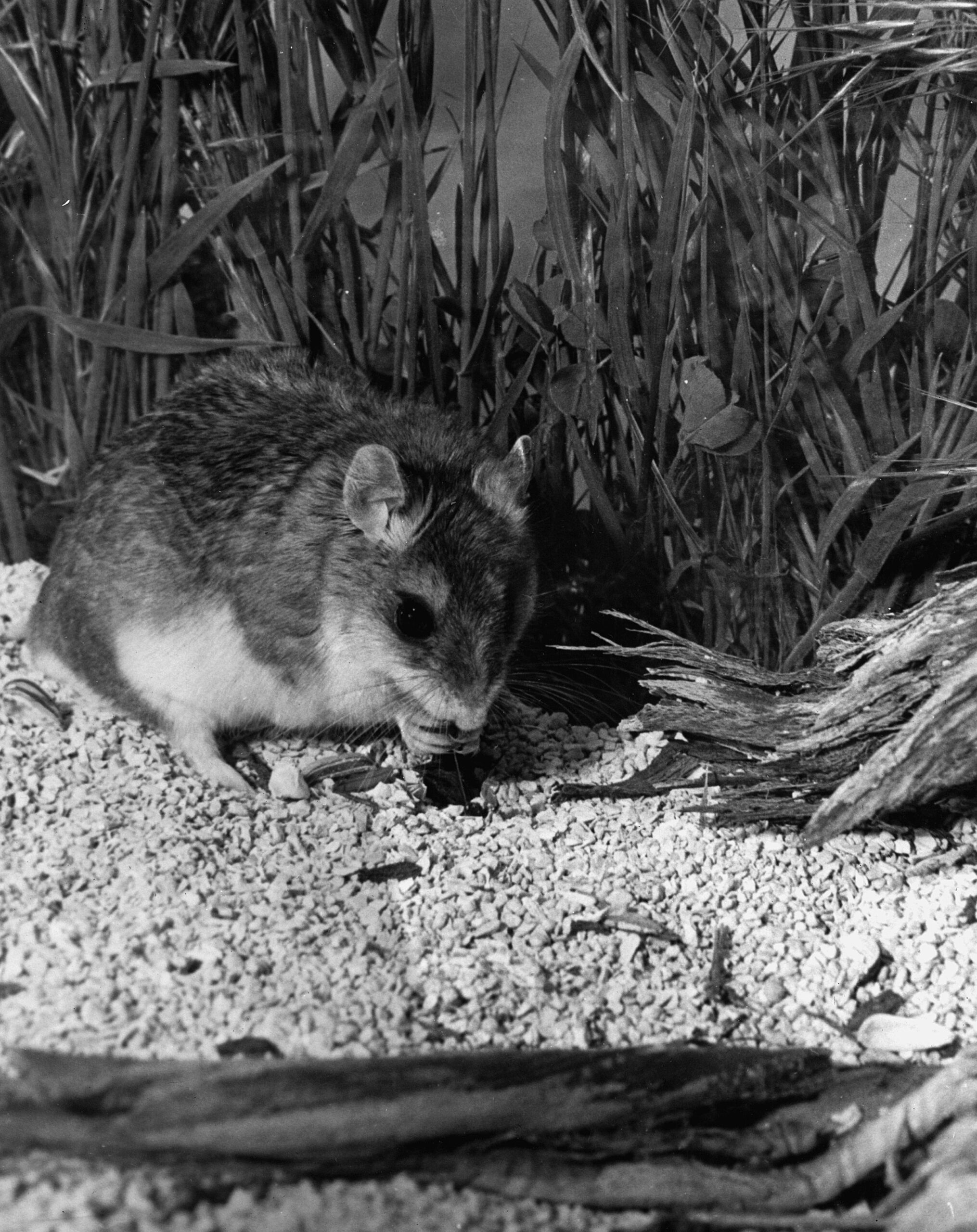
It starts with a sound that doesn’t belong in the night—a sharp, saw-edged scream that makes the desert go still for half a heartbeat. Not a bird, not a rabbit, nor even a grasshopper, not anything you’d expect from something so small. Then it comes skittering out of the shadows: the grasshopper mouse. Cute at a glance, sure—big eyes, soft fur, that tidy little face. But that’s the mask. Under it is a creature that’s too hungry, too carnivorous, and far too pleased with itself.

Grasshopper mouse – wikipedia

It moves like it owns the ground. Quick, confident, nose testing the smell like a bloodhound in miniature. Its hunger isn’t the mild, tidy kind. It’s the kind that looks for heat and motion. The type that makes it pause, head cocked, listening for a cricket’s scrape or a scorpion’s faint drag through sand. And when it hears it—when it knows—its whole body tightens like a spring.

Then it strikes. No dithering, no hesitation. It doesn’t “sample” prey; it takes it. A pounce, a bite, and those little jaws go to work with disturbing purpose. In the dark, it’s all business: pin, tear, chew. The desert is full of things that live on seeds and prudence, but this one lives on meat and nerve.

And that scream—lord, that scream. The grasshopper mouse tips its head back like it’s calling the night to order, and it lets loose again, a thin, triumphant howl scaled down to rodent size but carrying the attitude of something ten times larger. It doesn’t sound afraid. It sounds like a declaration. Like it’s telling every crawling thing in the sand: I’m here, and I’m hunting.

Too hungry. Too carnivorous. Too bold. It’s a pocket-sized outlaw of the desert, wearing a baby face and making a living the old-fashioned way—by taking what it wants and daring the world to argue about it.

It moves like it owns the ground. Quick, confident, nose testing the air like a bloodhound in miniature. Its hunger isn’t the mild, tidy kind. It’s the kind that looks for heat and motion. The kind that makes it pause, head cocked, listening for a cricket’s scrape or a scorpion’s faint drag through sand. And when it hears it—when it knows—its whole body tightens like a spring.

Then it strikes. No dithering, no hesitation. It doesn’t “sample” prey; it takes it. A pounce, a bite, and those little jaws go to work with unsettling purpose. In the dark, it’s all business: pin, tear, chew. The desert is full of things that live on seeds and caution, but this one lives on meat and nerve.

And that scream—lord, that scream. The grasshopper mouse tips its head back like it’s calling the night to order, and it lets loose again, a thin, triumphant howl scaled down to rodent size but carrying the attitude of something ten times larger. It doesn’t sound afraid. It sounds like a declaration. Like it’s telling every crawling thing in the sand: I’m here, and I’m hunting.

Too hungry. Too carnivorous. Too bold. It’s a pocket-sized outlaw of the desert, wearing a baby face and making a living the old-fashioned way—by taking what it wants and daring the world to argue about it.

Corridor Identification

A) The Mojave River spine (Colorado River → eastern Mojave springs → Mojave River corridor → Cajon Pass → San Bernardino/LA)

Mojave Indian Trail; Mojave River Trail; Mojave Road; Old Spanish Trail (where it drops into/uses Mojave River and related desert crossings); Beale’s Wagon Road (in its CA desert segment); Brown’s Toll Road (as the Cajon gateway upgrade); plus the generic “Wagon Roads” label when you’re talking about the 19th-century wagonable evolution of the same line.

The idea is simple: reliable water spacing and a workable pass dictated the alignment. The Mohave Trail conceptually underlies the later Mojave Road, and the NPS explicitly treats the Mojave Road through Mojave National Preserve as a branch of the Old Spanish National Historic Trail. Beale’s route description also ties his Mojave Desert segment to the Mojave Trail/Old Spanish Trail network, then notes the junction with the Mormon Road at the Mojave River. Brown’s Toll Road is best understood as “the Cajon Pass switch” that made the desert–coast connection more serviceable (toll/improvement era), not a whole new long-distance corridor by itself.

B) The LA ↔ Salt Lake “southern route” family (good-roads era branding laid over older travel)

Salt Lake Road; Old Spanish Trail (northern route pieces); Arrowhead Trails Highway; and again “Wagon Roads” as the pre-auto baseline.

This is the family that turns into the famous LA–Las Vegas–Salt Lake motor corridor in the auto-trails era. The BLM’s Arrowhead Trails Highway page is blunt about the lineage: the proposed/marketed auto route followed the late-19th-century “Old Mormon Road” and the earlier Old Spanish Trail. The Arrowhead Trail’s “association/branding layer” starts in 1916 (organized/incorporated that year) and is essentially a named-trail wrapper on that corridor.

C) “Good Roads” transcontinental overlays (names that often ride on top of existing roads, then feed into numbered highways)

National Old Trails; Midland Trail; Route 66 (as the numbered successor in the Southwest); and sometimes Arrowhead Trails Highway where it shares pavement with the NOTR in Southern California.

The key point: these aren’t necessarily new alignments end-to-end; they’re promotional/organizational systems that sign and improve what counties and states already had. FHWA and other summaries describe the National Old Trails Road Association as one of the early major named-trail movements (founded 1912). In the West, big stretches of the NOTR were later folded into US 66, which was established/commissioned in 1926 (signing followed). The Midland Trail is another early signed transcontinental auto trail (signed by 1913) that overlaps conceptually with the named-trails era rather than replacing everything on the ground.

D) The Sierra/Eastern Sierra north–south family (LA ↔ Mojave ↔ Owens Valley and beyond)

Sierra Highway / El Camino Sierra.

This one is its own long corridor family, and it intersects the desert east–west systems at junction towns rather than duplicating them. It’s commonly framed as an early 20th-century promoted route (established/advertised early, with later highway rebuilds) connecting Los Angeles into the Eastern Sierra.

E) The Tejon/Tehachapi gateway family (LA Basin ↔ San Joaquin Valley crossings)

Fort Tejon Road; Ridge Route.

Think “northbound exit from the LA Basin” rather than “Mojave crossing.” The Los Angeles–Fort Tejon Road is described as a successful wagon road solution over/near the Tehachapi barrier, completed in 1855. The Ridge Route is the early engineered state highway-era answer (opened 1915) that finally made that link paved and direct in the automobile age.

F) San Bernardino/San Gabriel mountain connectors (coast ↔ mountain communities, not trans-desert corridors)

Rim of the World Drive; Angeles Crest Scenic Drive (Angeles Crest Highway); Van Dusen Road.

These are “mountain access projects” more than “interregional desert crossings.” Rim of the World Drive is documented as opening in 1915 to connect San Bernardino with Big Bear through the range. Angeles Crest Highway construction begins in 1929 and the completed through-route opens much later (mid-20th century). Van Dusen Road sits here as an earlier wagon-road era Big Bear/Holcomb access line tied to the 1860–61 gold rush logistics (often described as a wagon road built in 1861).

G) Death Valley–Panamint access network (mining roads, toll-road tourism era, park-era backroads)

West Side Road (Death Valley); Road to Panamint; Eichbaum’s Toll Road (same as “Eichbaum Toll Road”).

This family is its own ecosystem: borax-era freight roads, mining camp supply lines, then purpose-built access to resorts/tourism. NPS frames the borax era as transport over “primitive roads” (1883–1889). The Eichbaum Toll Road is well-documented as a 1925–26 build from near Darwin to Stovepipe Wells (i.e., a deliberate west-side entry improvement). “Road to Panamint” is best treated as the umbrella for the Panamint Valley/Skidoo/Rhyolite road-pushing phase in the 1906–1907 window and its successors; NPS history material and HAER/other documentation talk explicitly about wagon-road development and the Rhyolite–Skidoo road beginning in 1906 and being in use by 1907. West Side Road is the park backroad line on the valley floor’s west side (modern status aside), squarely in the “Death Valley internal access” bucket.

Heritage Branding

A look out the window

Heritage branding and administrative designations (late name layers)
In the late 20th and 21st centuries, “historic” names often return as interpretive overlays: scenic byways, trail designations, monuments, and NRHP listings. These don’t always match the exact historic alignment, but they do become the public-facing name people repeat. (That’s not “wrong,” it’s just a different layer—commemoration rather than navigation.)

If you want a practical system for understanding Mojave pages, the old-fashioned way works best: treat names like strata. For any road/trail/place page, keep a short “Naming” paragraph that explicitly separates

(1) earliest known/traditional name,
(2) Spanish/Mexican-era name if applicable,
(3) wagon-era name,
(4) auto-trail/highway-era name,
(5) modern heritage/administrative name.

Then, when a reader asks, “Which is correct?” :
“all of them—just not in the same decade, and not for the same user group.”

Look out the window: Mojave naming changes usually aren’t random—they’re the paper trail of who was moving (and why) at a given moment. When feet become wagons, wagons become cars, and cars become heritage tourism, the corridor stays put, but the name on the map keeps changing with the times.

Mono Lake

https://digital-desert.com/mono-lake

Mono Lake, located near Lee Vining, is a unique and fascinating natural wonder in California. This saline soda lake is known for its mesmerizing tufa towers and limestone formations that rise from its surface. These towers, created over thousands of years by interacting freshwater springs and alkaline lake water, create a surreal and otherworldly landscape.

The lake itself covers an area of about 70 square miles and is an important habitat for a variety of plant and animal species. It is particularly famous for its abundant birdlife, including migratory birds such as Wilson’s phalarope and California gull. The lake’s brine shrimp and alkali flies attract many migratory birds, making it a birdwatcher’s paradise.

Visitors to Mono Lake can explore its beauty and learn about its unique ecosystem through various activities. One of the most popular activities is a scenic drive along the Mono Lake Scenic Area, which offers breathtaking views of the lake and its surroundings. Visitors can stop at several viewpoints and interpretive signs to learn about the lake’s geology, wildlife, and cultural history.

Guided tours are available for those looking to get a closer look at the Tufa Towers. These tours provide an opportunity to walk among the tufa formations and learn about their formation and significance. It is important to note that climbing on the tufa is strictly prohibited to preserve their delicate nature.

In addition to the lake itself, the town of Lee Vining offers a range of amenities for visitors. There are several lodging options, restaurants, and shops where visitors can relax and refuel after a day of exploring Mono Lake. The town also serves as a gateway to nearby attractions, such as Yosemite National Park and the Eastern Sierra Nevada mountains.

Overall, visiting Mono Lake and Lee Vining is necessary for nature lovers and those seeking a unique and awe-inspiring experience. Whether you are interested in the lake’s geological wonders, its diverse birdlife, or simply enjoying the tranquility of the surroundings, Mono Lake offers something for everyone. So, you can plan your visit and immerse yourself in the natural beauty of this extraordinary destination.

Rainbow Basin

/rainbow-basin/

Rainbow Basin is a unique geological formation in the Mojave Desert in California, United States. Spanning over 1,800 acres, this breathtaking landscape is known for its vibrant colors and fascinating rock formations.

The basin gets its name from the colorful layers of sedimentary rock that are exposed on the surface, creating a stunning visual display. These layers were formed over millions of years due to various geological processes, including the deposition of sediments, erosion, and the uplifting of the Earth’s crust.

One of the main attractions of Rainbow Basin is its diverse range of colors. The rocks here display shades of red, orange, yellow, green, and purple, creating a natural rainbow-like effect. This vibrant palette results from the minerals in the rocks, such as iron oxides, manganese, and copper.

The unique rock formations in Rainbow Basin are also breathtaking. Their intricate shapes and patterns provide a fascinating glimpse into geological history.

Aside from its geological wonders, Rainbow Basin is also home to various plant and animal species. Desert vegetation thrives in this arid environment, with cacti, shrubs, and wildflowers dotting the landscape. Wildlife enthusiasts can spot animals like the desert tortoise, jackrabbits, and various bird species.

Exploring Rainbow Basin is a treat for outdoor enthusiasts and nature lovers. The area offers several hiking trails that allow visitors to immerse themselves in the desert’s beauty.

Visitors to Rainbow Basin should come prepared with water, sunscreen, and sturdy footwear, as the desert environment can be harsh. It is also important to respect the fragile ecosystem and follow any posted regulations to preserve this unique natural wonder.

In conclusion, Rainbow Basin is a mesmerizing destination showcasing nature’s wonders. With its vibrant colors, stunning rock formations, and diverse wildlife, it offers a truly unforgettable experience for those who venture into the Mojave Desert. Whether you are a geology enthusiast, a nature lover, or simply seeking a unique outdoor adventure, Rainbow Basin is a must-visit destination.

Willow Beach

/willow-beach/

Willow Beach is a picturesque destination located on the shores of Lake Mojave. Situated in the Mojave Desert, this serene location offers visitors a tranquil escape from the hustle and bustle of everyday life.

One of the main attractions of Willow Beach is its stunning natural beauty. The crystal-clear waters of Lake Mojave provide the perfect backdrop for a variety of outdoor activities. Whether you’re interested in fishing, boating, or simply relaxing on the beach, you’ll find plenty to do in this idyllic setting.

Fishing enthusiasts will be delighted that Willow Beach is known for its excellent trout fishing. The lake’s stocked rainbow trout provide a thrilling challenge for anglers of all skill levels. With the picturesque surroundings and the thrill of the catch, fishing at Willow Beach is an experience like no other.

For those who prefer to explore the lake by boat, Willow Beach offers boat rentals and a marina. Whether you’re interested in cruising along the shoreline or venturing further into the lake, you’ll have the opportunity to take in the breathtaking views and maybe even spot some wildlife.

If you’re looking for a more leisurely experience, you can relax on the sandy shores of Willow Beach. The beach offers picnic tables and shaded areas, making it the perfect spot for a family outing or a romantic picnic by the lake.

In addition to its natural beauty, Willow Beach also offers amenities for visitors. There is a visitor center where you can learn more about the area and its history. Additionally, there are restroom facilities and a store where you can purchase fishing supplies, snacks, and souvenirs.

Willow Beach on Lake Mohave is a captivating destination offering visitors various activities and amenities. Whether you’re an avid angler, a boating enthusiast, or simply seeking a peaceful nature retreat, Willow Beach will surely leave you with lasting memories of its serene beauty.

The California Method

From the revised Journals of Jedediah Smith edited by Walter Feller

About 18 miles from the first mentioned creek, we crossed another 80 yards wide in appearance like the first, and three miles further came to a farm. In this distance, we had passed many herds of cattle belonging to the residents of the Angel village and some thousands of wild horses. The wild horses sometimes become so abundant to eat the grass relatively clean.

My guide informed me that the village’s inhabitants and vicinity collect whenever they consider the country overstocked. They build a large and sturdy pen with a small entrance, and two wings extending from the access to the right and left. Then mounting their swiftest horses, they scour the country and surrounding large bands; they drive them into the enclosure by hundreds.

The brutal California method of training bridle horses

The California Method – Edward Vischer, 1874

They may lasso a few of the most handsome and take them out of the pack. A horse selected in this manner is immediately thrown down and altered, blindfolded, saddled, and haltered (for the Californians always commence with the halter). The horse can then get up, and a man is mounted. When he is firmly in his seat and the halter in his hand, an assistant takes off the blind the several men on horseback with handkerchiefs to frighten and some with whips to whip-raise the yell, and away they go. The poor horse, so severely punished and spooked, does not think of flouncing but dashes off at no slow rate for a trial of his speed. After running until he is exhausted and finds he cannot eliminate his enemies, he gives up.

He is tied for 2 or 3 days, saddled, and ridden occasionally. If he proves docile, he is bound by the neck to a tame horse until he becomes attached to the company, then let loose. But if a horse proves immediately refractory, they do not trouble themselves with him long but release him from his bondage by thrusting a knife to his heart.

Cruel as this fate may seem, it is a mercy compared to the hundreds left in the pack, for they die a most lingering and horrible death within a narrow space without the possibility of escape. Without a morsel to eat, they gradually lose their strength and sink to the ground making vain efforts to regain their feet, when at last, all-powerful hunger has left them, the strength to raise their heads from the dust, their eyes becoming dim with the approach of death, may catch a glimpse of green and widespread pastures and winding streams while they are perishing from want.

They die one by one, and at length, the last and strongest sinks down among his companions to the plain. No man of feeling can imagine such a scene without surprise, indignation, and pity. Indignation and wonder that men are so heartless and unfeeling. Pity for the noblest of animals dying from want amid fertile fields. A disgraceful fact to the Californians not credited to a single narrator but has been since corroborated.

Alfalfa

This article was written circa 1904

The cultivation of alfalfa has become an important industry in this
state and throughout the West. As San Bernardino County can claim the
first successful culture of this plant in the United States, a brief outline of
its history may not be out of place.

Lucerne Valley, Ca.

Alfalfa is the oldest grass known, having been introduced into Greece
from Media, 500 years before Christ. The Romans, finding its qualities good, cultivated it extensively and carried it into France when Caesar reduced Gaul. It has always been extensively cultivated in Europe under the name of lucerne, supposed to be derived from the province of Lucerne in Switzerland. The name alfalfa was given to the plant in Chili, where it grows spontaneously in the Andes as well as on the pampas of that country and of the Argentine Republic.

Oro Grande, Ca.

It was introduced into the United States as early as 1835—and probably
earlier—and attempts at cultivation in New York and other Eastern states
were unsuccessful.

In the United States Agricultural Report for 1872, Mr. N. Wyckoff, of
Yolo, Napa County, Cal, reports: “In the winter of 1854. I sowed four acres
with alfalfa, or lucerne, as it was then called, seed brought from Chili. As
far as I know, it was a part of the first parcel of seed brought into this
country. My sowing proved so foul with weeds that I plowed it up and
did not re-sow until 1864.” The United States Agricultural Report of
1878, a considerable production of alfalfa is reported from some of the
northern counties of the state.

In the winter of 1852-3, a party of Mormons arrived in San Bernardino from Australia. At least one of the party, Mr. John Metcalf, brought with him some alfalfa seed. This was sown on his place, now the Metcalf place on Mount Vernon Avenue, near First street. It was irrigated from Lytle Creek and did well, and the plant was soon cultivated by others. The seed was at first sold for $1.00 per pound and was distributed from San Bernardino to other points in Southern California. The early supply of seeds for Los Angeles was obtained from San Bernardino and the seed was taken from here to Salt Lake thus the alfalfa industry, one of the most important in Utah, was started. The alfalfa crop is now one of the most important of the county and San Bernardino County had, in 1900, more than six thousand acres seeded to this plant.

INGERSOLL’S CENTURY ANNALS OF
San Bernardino County
1769 to 1904 (201)

The Overland Trail

Camp Cajon
Camp Cajon Dedication

by J.C. Davis

An alkali flats

Over the sagebrush desert gray,
Through alkali patches pale,
It stretches away and away and away –
The weary overland trail.

Where they who followed have smoothed the path
For the track of the iron horse
Between the rocks and around the hills
It threads its sinuous course.

And ever the wagon tracks diverge,
Like strands of a parted skein;
And anon the old trail straightens out
And gathers them again.

Eagle Butte

When bison fleeing the red man’s chase
Stampeded the toiling train.
And dust clouds rose as thundering herds
Swept over the rolling plain.

These deep-worn ruts that divide the bank
At this dry arroyo’s brink
Still tell of the awful, maddening thirst
Of the beasts that rushed to drink.

Wagon

Rushed down to drink, too oft, alas,
To find but a bed of dust,
Or, here and there, a sunken pool
White with alkali crust.

And many a rock was an ambuscade
That sheltered a skulking foe;
And wild shrieks echoed the Indian yell,
While men and women and children fell
And arrows flew like snow.

Unnamed graves

And smoking heaps in the dawn-light gray
Unfolded the tragic tale
Of the wagon camp that was sacked and burned
On the winding, windswept trail.

And many a ghastly heap of bones,
Bleached white by the sun and wind,
Is the final record of man or beast
That faltered and fell behind.

Who runs may read, as he speeds along,
Its record of blood and tears;
May see dim specters wan and worn,
The ghosts of the vanished years.

My heartbeats quicken, the trail grows dim,
My eyes are blind with tears
As | think with pity and pain and pride
Of those daring pioneers.

And in fancy I see, as my palace winged
Flies over the iron rail
The long, slow-creeping, wagon train
That traveled the overland trail.