Introduction
The east side of Owens Valley developed as more than a scattering of isolated mines. It became a connected industrial strip linking the mineralized slopes of the Inyo Mountains to wagon roads, lake-edge landings, smelters, and transfer points on the valley floor. In this system, ore did not simply come out of the mountains and disappear. It moved through a chain of infrastructure. Cerro Gordo and related districts supplied the resource base; Keeler, Swansea, and other shore-side points handled staging, transport, and processing; Owens Lake itself briefly functioned as an internal transport surface. What emerged was a compact but highly integrated extraction network, one shaped by topography, freight logic, and the temporary usefulness of the lake basin. Today, ruins, roads, slag, and abandoned townsites still mark that industrial layer across the east side of the valley.
Resource Zone – Inyo Mountains
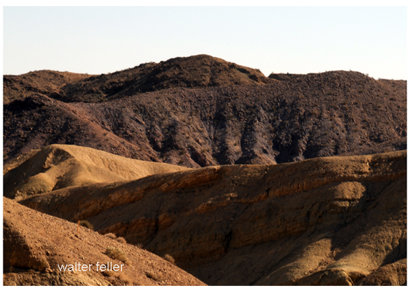
The industrial system began in the Inyo Mountains, where ore bodies in the eastern wall of the valley drove the development of camps, roads, and freight routes. The best-known node in this belt is Cerro Gordo, whose silver and lead production made it one of the dominant extraction centers tied to Owens Valley. Other mountain-side sites and supporting works formed part of the same general pattern: mineral wealth concentrated in the range, but movement and processing depended on infrastructure below.
This creates the first rule of the mining belt:
mountains produce, valley systems move.
Descent to the Valley Floor
Ore had to descend from steep mountain districts to usable transfer points on the valley floor and lake margin. That required wagon roads, freight teams, landing sites, and service settlements positioned where mountain output could enter a broader transport chain. In structural terms, the east face of Owens Valley was not just a scenic boundary. It was an industrial wall, feeding material down into a narrow working strip between mountain front and lake.
This descent zone linked extraction to infrastructure. Without it, the mines remained isolated. With it, they became part of a valley-wide industrial system.
Lake-Edge Processing and Transfer System
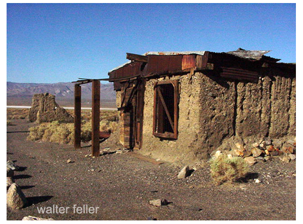
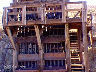
Once ore reached the lower basin, it entered the lake-edge belt. This is where sites such as Keeler, Swansea, and the Keeler smelter become central. These were not random settlements. They were functional nodes positioned to receive mountain output, process material, and pass it along.
Keeler operated as one of the principal lake-edge settlements tied to the Cerro Gordo system. Swansea formed part of the same industrial shoreline logic. Smelting and staging at the lake margin turned raw extraction into a more organized production chain. The shoreline became a working interface between mountain mining districts and wider transport systems.
Owens Lake Transport Layer
One of the most distinctive parts of the east-side industrial system was the temporary use of Owens Lake as transport infrastructure. Steamers and barges turned the lake into a connective surface, allowing freight and materials to move across the basin more efficiently than they could by rough overland detours around the shoreline.
This matters because it shows that Owens Lake was not only a natural terminal basin. For a time, it was also an industrial tool. The lake helped compress distance inside the valley and linked separate industrial nodes into a more coherent operational system.
That is one of the defining insights of the mining belt:
the lake itself became part of the machinery.
Industrial Decline
The system was never permanent. Its stability depended on ore production, freight economics, and the continued usefulness of lake-based transport and shoreline industry. As mining output declined, transport patterns changed, and new rail and road systems altered regional logistics, the lake-edge industrial network weakened.
Later hydrologic change deepened the collapse. The transformation of Owens Lake from a standing terminal lake into a largely dry playa stripped away the basin condition that had once helped support this industrial pattern. What remained were fragments: declining towns, abandoned works, smelter traces, and disrupted industrial relationships.
Residual Landscape
The east side of Owens Valley still preserves the remains of this system in visible form. Keeler survives as a diminished settlement with a strong ghost-town character. Swansea persists as a ruin field and historical footprint. Smelter remains, road traces, cemetery landscapes, lake-edge industrial scars, and mountain freight alignments all continue to mark the old belt.
These remnants should not be treated as isolated curiosities. Together they form a legible industrial landscape – one that still explains how the valley once functioned as an extraction corridor.
Corridor Integration
This industrial layer fits directly into your Owens Valley system:
- Bishop anchors the upper valley service and support layer, though the principal east-side mining belt intensifies farther south.
- Independence helps stabilize the central valley and provides administrative context for the industrial corridor.
- Lone Pine ties into the southern part of the valley system and helps frame the broader movement network connected to mining and freight.
- Olancha-Haiwee marks the point where the Owens Valley corridor transitions away from the main east-side industrial belt and toward Mojave-facing systems.
- The hydrology spine is inseparable from this story, because Owens Lake was once part of the industrial transport system and later, in altered form, became evidence of the valley’s transformed condition.
Significance
The Owens Valley east side was not just mined. It was systematically industrialized using the mountain front, valley floor, and lake basin as linked infrastructure. Ore came out of the Inyo Mountains, descended to transfer points, crossed or skirted the lake system, and moved through smelters and shoreline settlements in a connected chain. That makes the mining belt one of the clearest human-use layers in the valley: a short-lived but highly integrated extraction network built directly on geographic structure.
One-line Summary
The Owens Valley Mining Belt is the east-side industrial system where mountain ore, lake transport, and valley infrastructure combined into a tightly linked extraction network.
What was done: Built the Owens Valley Mining Belt as a unified industrial-layer page connecting Cerro Gordo, the Inyo Mountains, Keeler, Swansea, smelting, lake transport, and decline into one causal system.