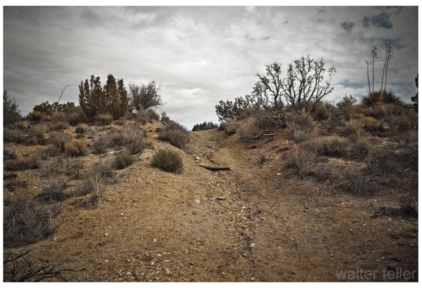
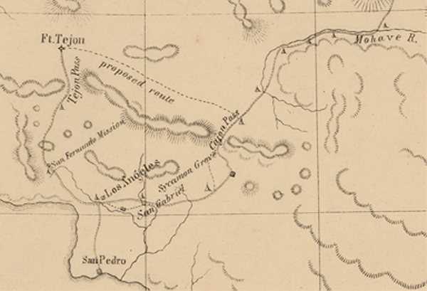
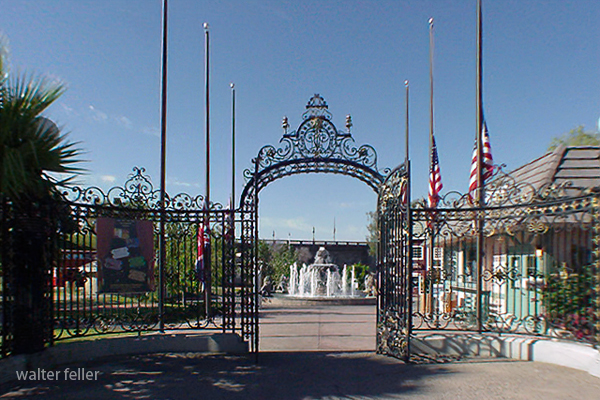
Fort Tejon Road refers to a historic route in California that leads to Fort Tejon State Historic Park. Fort Tejon was established in 1854 and served as a military outpost during the turbulent times of the 19th century, addressing issues related to the Gold Rush and conflicts with Native American tribes.
The fort is located in the Grapevine Canyon, part of the Tehachapi Mountains in Kern County. The Fort Tejon Road provides access to the park and passes through scenic landscapes. The area is known for its historical significance and is a popular destination for those interested in California’s history.
1855
Visitors to Fort Tejon State Historic Park can explore the well-preserved buildings, learn about the fort’s history through exhibits, and participate in various events and demonstrations. The park is managed by the California Department of Parks and Recreation and serves as a reminder of the state’s military and cultural history during the mid-19th century.
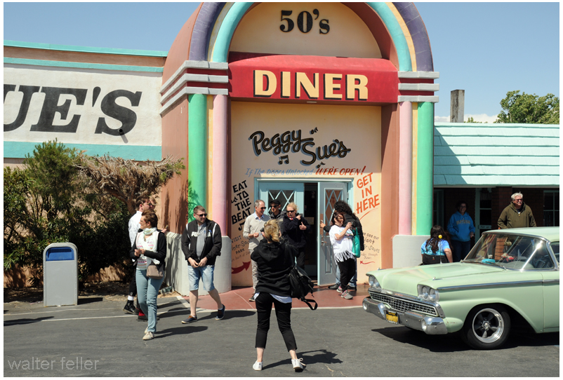
Peggy Sue’s 50s Diner is a well-known retro-themed diner in Yermo, California. It’s designed to resemble a classic 1950s diner, with vintage decor, neon lights, and a nostalgic atmosphere.
The diner typically offers classic American diner fare, such as burgers, shakes, fries, and other comfort food items. Additionally, Peggy Sue’s may have themed events or activities to enhance the 1950s experience for visitors.
The Mojave Desert, located in the southwestern United States, is a vast and captivating landscape known for its unique geological features and diverse ecosystems. Here are some activities you can enjoy in the Mojave Desert:
Kelso Dunes: Hike to the top of these iconic dunes for panoramic views of the desert landscape.
Hole-in-the-Wall: Explore the unique volcanic rock formations and hike through the scenic canyons of Hole-in-the-Wall.
Off-Highway:
Mojave Road: Embark on the historic Mojave Road, a 140-mile trail that takes you through the heart of the Mojave Desert. It’s a popular route for off-road enthusiasts.
Aerospace Museum: Discover the history of aviation and space exploration at the Mojave Air and Space Port, home to innovative aerospace projects.
Bird Watching:
The Mojave Desert is home to a variety of bird species. Bring binoculars and explore areas like the Amargosa River and nearby wetlands for birdwatching opportunities.
Photography:
Capture the unique landscapes, rock formations, and vibrant sunsets the Mojave Desert offers. Joshua Tree’s unique Joshua trees and the play of light and shadow make for excellent photographic opportunities.
Camping:
Enjoy camping under the desert stars at designated campgrounds in Joshua Tree National Park, Mojave National Preserve, and Death Valley National Park.
Remember to check weather conditions, carry plenty of water, and follow Leave No Trace principles when exploring the Mojave Desert. Always be aware of the desert’s extreme temperatures and take necessary precautions for a safe and enjoyable experience.
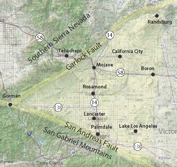
The Antelope Valley is a region located in northern Los Angeles County and southeastern Kern County in the state of California.
Here are some key geographical features and aspects of the Antelope Valley:
Location:
Counties: The Antelope Valley spans Los Angeles County to the south and Kern County to the north.
Topography:
Desert Landscape: The Antelope Valley is part of the Mojave Desert, characterized by a high desert landscape with arid conditions.
Valley and Basin: The region is named after the pronghorn antelope that used to roam the area. It is a valley and basin surrounded by mountain ranges, including the San Gabriel Mountains to the south and the Tehachapi Mountains to the northwest.
Cities and Communities:
Palmdale: One of the major cities in the Antelope Valley, located in Los Angeles County.
Lancaster: Another significant city in the region in Los Angeles County.
Quartz Hill: A community within the Antelope Valley, known for its agricultural history.
Rosamond: A community in Kern County, east of Lancaster, known for its aerospace industry.
Climate:
High Desert Climate: The Antelope Valley experiences a high desert climate with hot summers and cool winters.
Low Precipitation: The region receives relatively low annual precipitation, and water scarcity is a concern.
Agriculture:
Historical Agriculture: The Antelope Valley has a history of agriculture, especially in areas like Quartz Hill. However, water availability has posed challenges for sustained agricultural practices.
Edwards Air Force Base:
Military Presence: The Antelope Valley is home to Edwards Air Force Base, a major aerospace and flight test facility.
Transportation:
Highways: Major highways, including State Route 14 (Antelope Valley Freeway), connect the Antelope Valley to the rest of Southern California.
Natural Attractions:
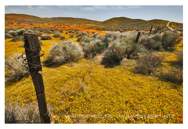
Poppy Reserve: The Antelope Valley California Poppy Reserve is a notable natural attraction, drawing visitors during the spring when wildflowers, including poppies, bloom.
Economic Activities:
Aerospace Industry: The aerospace industry, including Edwards Air Force Base and related activities, plays a significant role in the economy of the Antelope Valley.
Challenges:
Water Scarcity: Like many desert regions, water scarcity is a challenge in the Antelope Valley, and sustainable water management is crucial for the area’s development.
Understanding the geography of the Antelope Valley involves recognizing its desert setting, mountainous surroundings, urban centers, and economic activities.
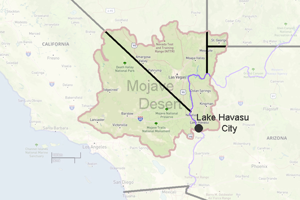
Lake Havasu City is a city located in Mohave County, Arizona. It is situated on the eastern shore of Lake Havasu, a large reservoir formed by the Parker Dam on the Colorado River. The city is known for its picturesque landscapes, outdoor recreational activities, and vibrant community.
Lake Havasu City was established in 1964 by real estate developer Robert P. McCulloch as a planned community. The city was designed to be a tourist destination and has since become a popular vacation spot and retirement location. The warm climate, sunny weather, and beautiful natural surroundings make it an ideal place for outdoor enthusiasts.
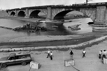
One of the main attractions in Lake Havasu City is the London Bridge. Yes, that’s right, the London Bridge. In 1968, McCulloch purchased the original 1831 London Bridge from the City of London and shipped it to Lake Havasu City. The bridge was reconstructed brick by brick and now serves as a major tourist attraction and the city’s centerpiece.
Lake Havasu is also a haven for water sports and boating enthusiasts. The lake offers various recreational activities, including fishing, jet skiing, paddleboarding, and kayaking. Boaters can cruise along the lake’s 450 miles of shoreline or anchor in one of the many secluded coves for a tranquil experience.
For those who prefer land-based activities, Lake Havasu City has numerous hiking and biking trails that showcase the area’s natural beauty. The surrounding desert landscape provides a unique backdrop for outdoor adventures. Visitors can explore the nearby Cattail Cove State Park, which offers camping facilities, hiking trails, and sandy beaches.
The city is also home to several annual events and festivals that attract visitors from all over. In January, the Lake Havasu Balloon Festival showcases colorful hot air balloons flying over the lake. The Lake Havasu Boat Show, held in April, features various boats and marine products. And during the summer, the city hosts the Fourth of July fireworks extravaganza, one of the largest in Arizona.
In addition to its natural beauty and recreational opportunities, Lake Havasu City has a thriving downtown area with shops, restaurants, and entertainment options. Visitors can stroll along the Bridgewater Channel, a pedestrian-friendly promenade parallel to the London Bridge. The channel has shops, eateries, and outdoor patios, offering a scenic and lively atmosphere.
Lake Havasu City, Arizona, offers natural beauty, outdoor recreation, and small-town charm. Whether you’re looking for a relaxing getaway or an exciting adventure, this city has something to offer everyone. So, pack your bags and prepare to experience Lake Havasu City.
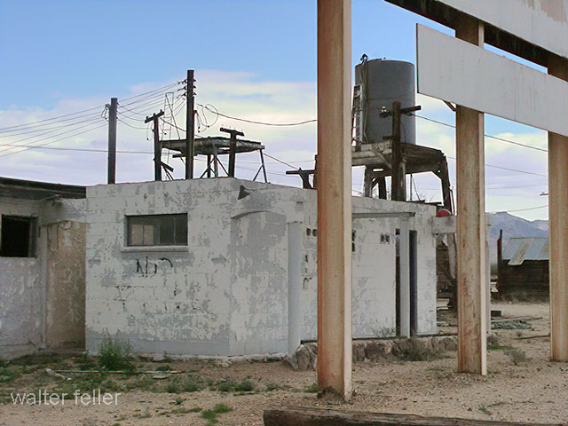
Essex is a small unincorporated community located in the eastern part of San Bernardino County, California, USA. Its history is closely tied to the development and expansion of the railroad and the mining activities in the region.
Here’s an overview of the history of Essex:
Railroad Development: The town’s history can be traced back to the construction of the Atchison, Topeka and Santa Fe Railway in the late 19th century. The railroad played a crucial role in the development of the American West, connecting various communities and facilitating the transportation of goods and people.
Mining Boom: Like many other towns in the region, Essex saw a boom in mining activities during the late 19th and early 20th centuries. The nearby Providence Mountains were known for their mineral deposits, attracting prospectors and miners seeking fortunes in gold and other minerals.
Railroad Town: Essex became a railroad town, serving as a strategic point for the railroad industry. It had a railroad depot, which was essential for loading and unloading goods transported by the trains. The railroad played a significant role in the economic life of Essex during its early years.
Decline: As the mining industry declined and transportation patterns shifted, the importance of towns like Essex diminished. Many of the mines closed, and the once-thriving communities began to decline. The decline in mining activities and changes in transportation methods, such as the decline of rail travel in favor of automobiles and highways, contributed to the economic challenges faced by Essex.
Route 66 Influence: Essex is also situated along the historic Route 66, a famous highway that connected Chicago to Los Angeles. During the mid-20th century, Route 66 became an iconic route for cross-country travel, and Essex served as a stopping point for travelers along this historic road.
Present Day: Today, Essex is a quiet and sparsely populated community. Many of its historic structures may still stand as reminders of its past, and the area may attract historians, photographers, and those interested in exploring the remnants of the old Route 66.
Essex’s history is intertwined with the broader historical developments of the American West, including the expansion of railroads, mining booms, and the evolution of transportation networks. While the town may no longer be a bustling hub, its history contributes to the rich tapestry of the region’s past.
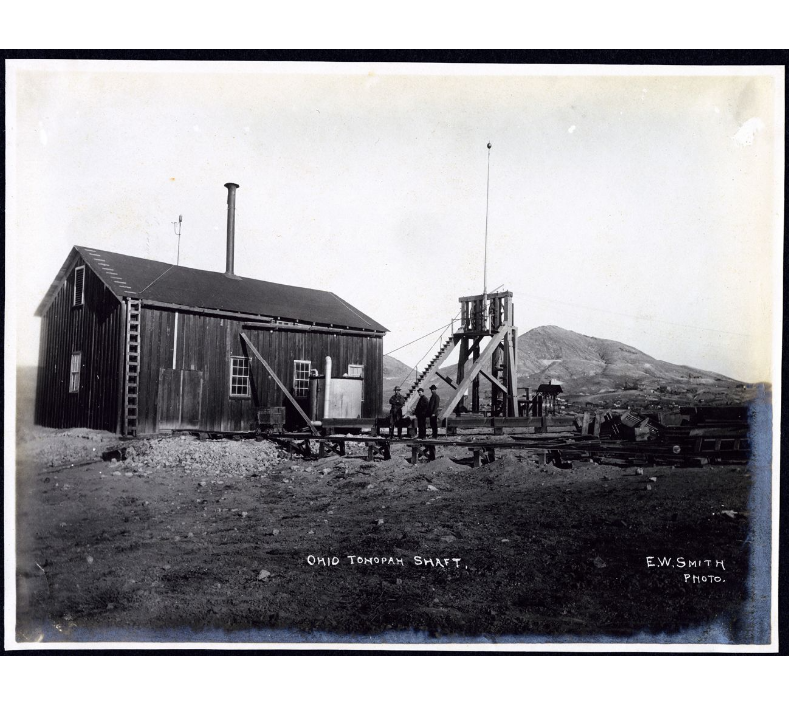
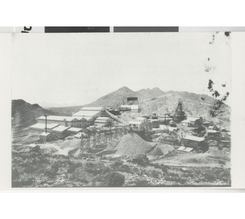
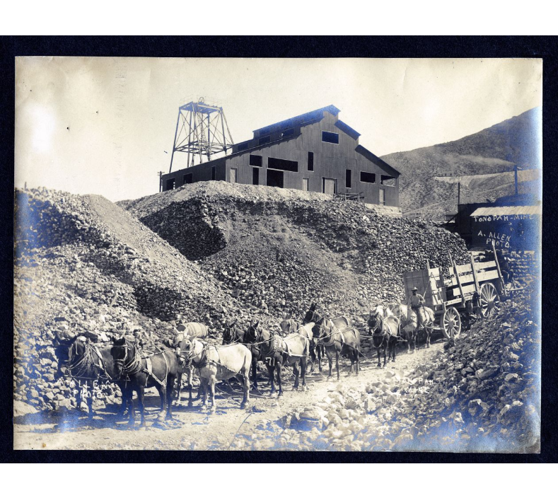
Tonopah was one of Southern Nevada’s most prosperous mining communities, drawing hundreds of prospectors from its founding in 1900. Silver was first discovered on May 19, 1900, by prospector Jim Butler who was traveling through the area. On an overnight stop, Butler discovered silver outcroppings near Tonopah Springs. When Butler’s friend Tasker Oddie (later Nevada Senator and Governor) had Butler’s sample assayed, it was found to be worth $50-$600 per ton. That August, Butler and his wife staked eight claims in Tonopah. Mrs. Butler christened the first three claims Desert Queen, Burro, and Mizpah. The Mizpah became Tonopah’s largest producer over the next forty years. Later that year, Butler leased his claims for one year, collecting 25% of the royalties from the gold and silver ore that was mined.
In 1901 several companies opened, including the West End Consolidated Mining Company and the Tonopah Extension Mining Company. In January, the mining camp had a population of 40, including three women. By springtime, the population rose to 250, and Tonopah’s first stage, the Concord, arrived from Sodaville. In May 1901, Tonopah’s first post office and the largest building in the city, The Mizpah Bar & Grill, opened. That summer, Tonopah’s population reached 650. W.W. Booth advertised the district through his newspaper, the Tonopah Bonanza. As word spread, more prospectors entered the area, and three large mining corporations were formed in early 1902: The Tonopah Belmont Mining Company, the Montana Tonopah Mining Company, and the Tonopah Mining Company.
The camp was still relatively primitive in 1902. Prices, crude sanitary conditions, and Tonopah’s isolation made it difficult to obtain supplies. This changed in early 1903 when construction began on a 60-mile-long narrow gauge railroad connecting Tonopah with the Carson and Colorado Branches of the Southern Pacific Railroad at the Sodaville Junction.
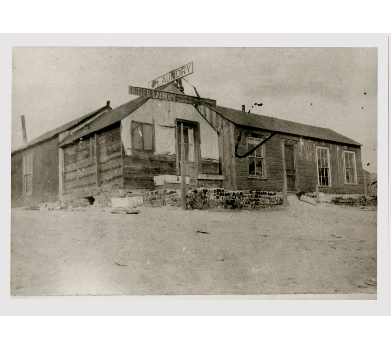
By the end of 1903, Tonopah’s population surged to 3,000. With several profitable silver and gold strikes, production boomed, and mining stocks listed on the San Francisco stock exchange since April soared. A building boom followed the mining boom. There were thirty-two saloons, six faro games, two dancehalls, two weekly newspapers, several mercantile stores, and two churches built before 1904. On July 25, 1904, the town celebrated the completion of the narrow gauge railroad with speeches, sporting events, horse races down Main Street, and several dances.
The population continued to grow as transportation to the district became easier, and by May 1905, the Nye County seat was moved from Belmont to Tonopah, the post office changed its name to Tonopah, and construction began on a new $55,000 Nye County courthouse. On July 7, 1905, Tonopah’s first city government was incorporated. In the fall, the two railroads in Tonopah merged into the Tonopah and Goldfield Railroad Company, its track gauge standardized and extended to Goldfield.
Tonopah survived the financial panic of 1907. The city had five banks, modern hotels, cafes, an opera house, a school, electric and water companies, numerous gambling halls, and several four to five-story buildings downtown. In 1908 and 1909, Tonopah was devastated by a series of fires. In May 1908, a fire destroyed an entire block of the commercial district. A year later, the roundhouse and the machine shops at the Tonopah and Goldfield Railroad burned to the ground. The infamous Belmont fire occurred on February 23, 1911, when the 1,200-foot mine shaft of the Belmont Mine caught fire. Seventeen men perished from the toxic fumes of the blaze.
Mining activity expanded in 1912 when the Belmont mine and mill began operating in July. The daily wage for a machine operator averaged $4.50-$5.50 per shift. The following year was Tonopah’s most profitable: Annual production in gold, silver, copper, and lead was valued at $10 million. Several mills were constructed to process 1,830 tons of ore daily, including the Tonopah Belmont Development Company’s massive 500-ton mill on the east side of Mount Oddie.
Tonopah reached its peak production between 1910 and 1914. Between the end of World War I and the Great Depression, four companies remained active: the Tonopah Mining Company, Tonopah Belmont, Tonopah Extension, and West End Consolidated Mines. In 1921, four of the twenty-five principal silver mines in the nation were still in Tonopah, and Tonopah was the nation’s second-largest producer of gold. But on October 31, 1939, a fire destroyed the Belmont Mine, and another fire in 1942 closed the Tonopah Extension Mill. World War II brought an Army Air Force Base to the area, but it was shut down upon the close of the war. When the Tonopah and Goldfield Railroad ceased operations in 1947, Tonopah’s remaining mines closed, and the population dwindled.
The total production of Tonopah’s mines over its forty years of production is estimated at over $150 million, and during that time, Tonopah produced many millionaires and statesmen, including Tasker Oddie, Jim Butler, Frank Golden, Zeb Kendall, and Key Pittman. In the words of Nevada historian Stanley Paher, “Virginia City had put Nevada on the map; Tonopah kept it there.”