That Looks Good

Desert photography starts out as a simple urge: “That looks good—take a picture.” If it stays there, it can go stale, because the camera becomes a souvenir machine and nothing more. But if you pull the pieces together—purpose, learning, editing, and display—it becomes something older and steadier: a craft that turns attention into knowledge, and knowledge into a record you can live with, share, and pass along.

The first part is purpose, because it keeps the work from turning into an endless string of casual snaps. In the desert, purpose can be as plain as an assignment. “Follow the wash and photograph what changes.” “Track an old route and record the artifacts.” “Show a plant community, not a single plant.” “Make a sequence that explains a place, not just a postcard.” When you have an assignment, you stop hunting for random pretty scenes and start asking the kind of questions that lead to better photographs: What is the subject? What is it doing here? What does the light reveal? What is the story the landscape is telling?

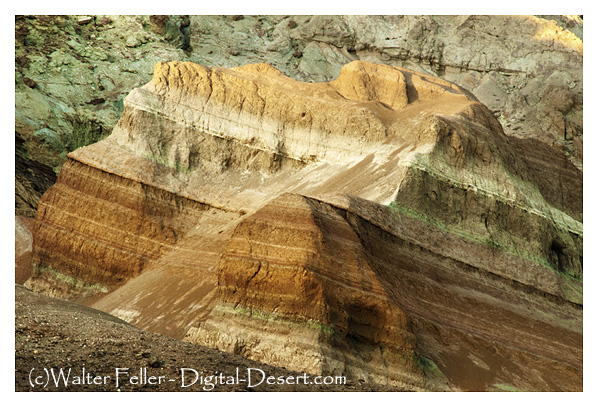
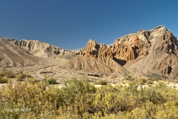
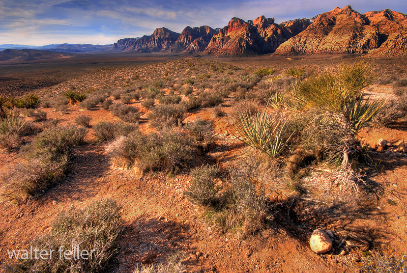
That’s what purpose does: it forces you to look longer. And in the desert, looking longer is the whole game. The desert isn’t loud the way a city is loud; it’s legible. A dry fan tells you where water used to run. A wash shows you how recent storms rearranged the ground. Desert varnish and pavement show the passage of time. A line of cottonwoods or reeds tells you where water persists even when everything else says “no.” Old grades, culverts, pole lines, and broken pavement show how people tried to solve the desert’s problems—water, distance, and heat—using the tools of their era. When your photography has purpose, you start photographing these clues on purpose. That’s the moment the camera stops being a mirror and starts being a notebook.

The second part is learning, because desert photographs can be more than attractive; they can be evidence. If you want your images to teach you something later—and teach other people something too—you need a simple discipline: shoot identifiers, not just beauty. For plants, that means the flower (if present), the leaves, the overall form, and the habitat context. For geology, it means a close-up texture shot, a mid shot showing where the rock sits, and a wide establishing shot showing the landform. For historic sites, this means details of construction, a sign or marker (if one exists), and the relationship to the landscape (because the landscape explains why the site is there). Add one shot that gives scale. It can be as simple as your boot near a track, a coin next to a fossil fragment (where legal and ethical), or a hand near a tool mark—anything that anchors size.

That method sounds almost dull, but it’s the opposite. It’s how you build a personal archive that gets more valuable with time. Later, when you want to confirm an ID, write an article, or compare changes across seasons, you have what you need. You’re not guessing. You’re working from proof.

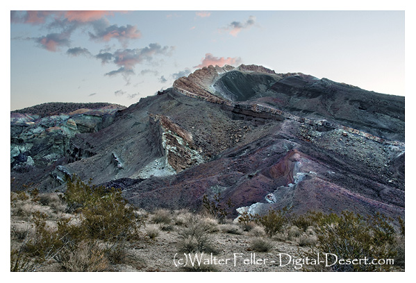
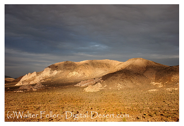
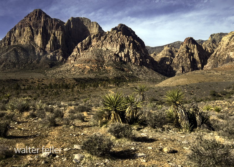
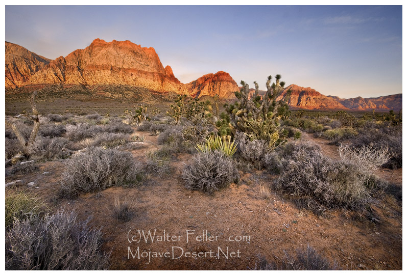
The third part is technique, and in desert work, technique is mostly about light, distance, and protection. Desert light is brutally honest. Midday sun flattens color, blows highlights, and makes the scene look harsher than it felt. Early and late light—side-light especially—reveals texture and makes the land readable. Overcast, though rarer in the desert, is excellent for plants and details because it reduces contrast and preserves color. After rain is its own gift: clearer air, richer tones, and sometimes standing water or damp sand that photographs like velvet. Distance is the next factor: heat shimmer can ruin long telephoto shots across a flat basin in the middle of the day, and wind can turn a gentle tripod setup into a vibrating mess. Protection is the constant: dust, grit, and sun don’t care what brand of camera you brought. The desert is hard on gear and harder on complacency.

But technique isn’t only about settings. It’s about how you choose to see. A phone can make fine desert photographs if you treat it like a camera and not a distraction. A “serious” camera gives you more control and consistency, but it doesn’t give you purpose. Purpose is earned.

The fourth part is editing, because editing is where your photographs become cohesive. Editing isn’t just “making it prettier.” It’s where you declare what you’re loyal to. Are you loyal to realism—making it look like it felt? Are you loyal to form—graphic lines and hard light? Are you loyal to color—subtle separation of tans, blues, and varnish-black? Are you loyal to the story—an image that serves a sequence more than it serves itself? Once you know your loyalty, the sliders stop being a casino and start being tools.

A good way to think about editing is in terms of “mode and style.” Mode is the job. Style is the repeated set of choices. Documentary realism is a solid mode for desert work because it respects the place. You protect highlights, keep color believable, lift shadows without flattening, and use sharpening with restraint so rocks look like rock rather than crunchy digital grit. Classic landscape is another: slightly deeper contrast, careful dodging and burning, and a “printed” look that suits wide scenes. Graphic high-contrast can be powerful too—especially on dunes, volcanic rock, road cuts, and old concrete—where shape and shadow are the story. Film-like or vintage styles can work, but only if you keep them consistent; otherwise, it becomes a costume you put on photos at random.

The most important editing decision is not what you add—it’s what you refuse. Decide your line in the sand. Many desert photographers do better the moment they reject heavy HDR halos, neon saturation, and fake skies. The desert has plenty of drama; you don’t need to manufacture it. Restraint reads as confidence.

The fifth part is display, because display is where the whole thing becomes real. A photograph that lives only on a hard drive is unfinished. Display is also where people get confused, because every output has different needs. A print for the wall is not the same as an image for a phone screen, and neither is the same as an image for publication.

For home display, you’re making something you’ll live with. That calls for calm editing, predictable sizes, and consistency. A single strong piece can anchor a room, but series work—washes, roads, dunes, textures—can turn a wall into a story. A traditional approach helps: standard sizes, consistent frame style, consistent mat color. The goal is for the work to read as a body rather than a pile.

For a gallery, cohesion is everything. A gallery show is not a “best of.” It’s a statement. Limiting sizes, limiting styles, and arranging images as sequences make viewers slow down and follow the logic. Captions matter more than people like to admit in landscape work. One sentence can turn a pretty scene into a scene with meaning: what it is, where it is, and why it matters. Desert photography especially benefits from this because the land is full of clues that most viewers don’t yet know how to read.

For gifts, you’re choosing ease and friendliness. Smaller sizes, a bit more brightness than you’d keep for yourself, and subjects that communicate immediately. A clean Joshua tree silhouette, a classic road fragment, a dramatic ridge line—these are images people can place in their own homes without needing the backstory. You can still include the backstory, but the gift should stand on its own.

For publications, you’re in a world of specifications, accuracy, and reproducibility. You keep color conservative, avoid heavy sharpening, and give editors room for crop and caption. A publication image is as much about clarity as it is about mood. In this setting, your photographs become a form of documentation—proof again—especially when they support a narrative about history, ecology, or place.

When you combine these parts, you can finally answer what it means and what it does.

What it means is that desert photography becomes a form of attention practiced over time. It’s a way of noticing that isn’t casual. You go out with a purpose, you learn what you’re seeing, you refine how you translate it into an image, and you finish it in a form that can be shared. In other words, it becomes a craft rather than a pastime. The desert rewards craft because it’s a place where small differences matter: a slight change in slope tells a water story; a slight change in soil tells a plant story; a slight change in light turns a flat scene into a readable one.

What it does is equally concrete. It builds a personal archive that grows in value over time. It trains your eye to recognize patterns. It gives you a record of places that change—sometimes slowly, sometimes abruptly. It creates material for sharing: a wall series, a booklet, a website page, a classroom talk, a gift that carries a place into someone else’s home. It also has a quiet civic function: photographs can support memory, and memory can support stewardship. When you have images that show how a site looked, where a route ran, what a wash did after a storm, or what a grove of cottonwoods looked like before a dry year, you have evidence. You can argue from something more solid than nostalgia.

There’s also a personal effect that’s easy to underestimate: purpose-driven photography makes desert time feel fuller. A day out stops being “a drive with a few stops” and becomes “a study of a place.” Even if you come home with only a handful of images worth keeping, you still have knowledge.

Wright & Troxel

A learning tool

All right, here’s the whole story. No jargon, no technical formatting, just the history of how Lauren Wright and Bennie Troxel shaped our understanding of Death Valley, Tecopa, and the southern Mojave region.

Eagle Mountain

Lauren Wright and Bennie Troxel spent their lives in the desert. Starting in the early 1950s, they mapped the roughest country in Death Valley and beyond. What others called chaos, they patiently untangled, rock by rock. Over the years they became two of the most trusted voices in Basin and Range geology, known for their steady field habits, clean maps, and deep respect for what the land itself could tell them.

They began in Death Valley, working through the twisted terrain east of Badwater and Furnace Creek. There, scattered fault blocks looked like a puzzle someone had shaken apart. Wright and Troxel figured out that this “Amargosa Chaos” wasn’t random at all. It was the result of the crust stretching and tearing at low angles, lifting old rocks and dropping young ones. Their maps from the 1960s and 70s showed that the Valley wasn’t just a crack in the earth, but part of a much larger system in which the crust itself was thinning.

They studied the Furnace Creek and Death Valley fault zones and showed that the sideways, or strike-slip, motion wasn’t as massive as some believed. The land was moving both sideways and downward — sliding, stretching, and rotating all at once. Their careful work stopped wild speculation and grounded future studies in what could actually be seen in the rocks.

Later, when the field began to recognize “detachment faults” — those broad, low-angle breaks deep in the crust — Wright and Troxel were already there. They had mapped them years before anyone had a name for them. Their diagrams of tilted mountain blocks, uplifted footwalls, and sinking basins became the foundation for how geologists now picture the Basin and Range province.

Their influence spread southward, into the Tecopa and Shoshone area. Tecopa Basin, once thought of as just a dried-up lake, became under their framework a living tectonic basin — a place still moving, still changing. The basin sits between the Resting Spring Range on the east and the Nopah Range on the west, both tilted blocks bounded by faults. Wright and Troxel’s regional mapping explained how those ranges rose and the basin sank, all part of the same crustal stretching that shaped Death Valley.

The Resting Spring Range, they showed, is a footwall block lifted on a west-dipping detachment fault. That fault likely channels the hot water that feeds Tecopa’s springs. Across the basin, the Nopah Range tilts the other way, dropping the valley floor between them. The lake beds and alluvial fans that fill the basin record every stage of that movement. Their approach — always linking sediments, structure, and landscape — became the standard way of reading desert basins.

Following their line of thought south, the fault belt continues through Sperry Wash to the Kingston Range. There the crust was pulled so thin that deep rocks rose to the surface. Later researchers would prove the Kingston Range to be a metamorphic core complex, but it was Wright and Troxel’s earlier insight into Death Valley’s structure that pointed the way. They showed that the same forces that opened Death Valley also lifted the Kingston Range and dropped the Tecopa Basin between them.

At the southern edge of this chain lies the Avawatz Mountains, a natural hinge between the stretching Basin and Range and the sliding Mojave block. Wright and Troxel understood this as the turning point — where extension gives way to sideways shear. The Garlock Fault lies just to the south, a great east-west fracture that shifts motion from one style to another. They were among the first to argue that these systems are connected, not separate. The Garlock doesn’t stop Death Valley; it redirects it.

South of the Avawatz, the story continues through Soda and Silver Lakes, the broad dry basins near Baker. These, too, line up along the same fault trend. The Mojave River, flowing northward from the mountains through Barstow, traces that same old scar in the crust. The river’s course isn’t random — it follows a tectonic path carved long before any water ran through it. Every terrace, canyon, and dry lake along its route echoes the same pattern Wright and Troxel mapped farther north.

By the time the river reaches Afton Canyon and the dry sinks of Cronese and Soda Lake, it’s running through the tail end of their structural corridor. The ground here still moves, slowly and quietly, along the Lenwood, Lockhart, and Helendale faults. These smaller strands pick up the motion of the Garlock and pass it westward toward the San Andreas. The Mojave River flows right through the middle of it all — a living reminder of how deep-seated tectonics shape even the surface flow of water.

Wright and Troxel’s gift was not just their data but their way of seeing. They treated the desert as a single, connected organism — every basin, every fault, every dry lake part of the same long rhythm of motion. Where others saw disjointed ranges, they saw a story of continuous transformation, stretching from Furnace Creek to Barstow and beyond.

Their maps still hang in field camps and classrooms, and the Geological Society of America’s Wright–Troxel Award continues to support students studying these same basins. The accuracy of modern GPS and seismic work has only confirmed what they drew by hand half a century ago.

In the end, their legacy is both scientific and human. They showed that patient fieldwork, careful observation, and respect for the land can turn confusion into clarity. Thanks to them, the Mojave and Death Valley are no longer a tangle of broken hills but a single, coherent landscape — one long story written in the language of stone.

As a Play

You could think of the Mojave Desert as a grand Broadway production—ancient, dramatic, and full of subtle choreography that has played out for millions of years.

view from walker pass

The stage is the geology: immense backdrops of folded mountains, tilted strata, and fault lines painted by time. Volcanic cones serve as spotlight towers, alluvial fans sweep like curtains drawn across the basin floor, and the Mojave River cuts a wandering path like a traveling stagehand moving props between acts.

The set is built from plants, rocks, and the occasional weathered structure. Joshua trees rise like eccentric stage pieces, each with its own pose under the lights. Creosote bushes fill in the ensemble—reliable, understated performers who know every cue. Abandoned mining cabins, ghost towns, and derelict rail ties serve as the props and scenery from earlier acts, remnants left between scenes of prosperity and decline.

The lighting crew is the sun, directing each scene with precision—blinding spotlights at noon, warm amber tones at dusk, and moonlit silver rehearsals after dark. The wind adds the soundtrack, whispering through canyons or howling like a restless audience.

The actors? Coyotes, bighorn sheep, and lizards—all improvising within a script written by climate and time. Even the rain, when it shows up, steals the scene with a brief but powerful soliloquy, transforming everything for one fleeting act before bowing out again for months, sometimes years.

Every performance is different, but the play never closes. The Mojave’s production runs continuously, with geology always holding center stage and life finding its cues wherever it can.

Geologic Diversity

When someone mentions they are a geologist, it’s easy to assume that all geologists do the same thing. However, geology is a diverse and multifaceted field, encompassing a wide range of specialties. Each geologist may focus on different aspects of the Earth’s structure, materials, processes, and history. Here’s a more detailed look at the various types of geology and the distinct roles that geologists might have:

Types of Geology

  1. Structural Geology: Geologists in this field study the architecture and processes responsible for the deformation of the Earth’s crust. They analyze faults, folds, and rock formations to understand tectonic movements and stress patterns.
  2. Petrology: Petrologists examine the origin, composition, and structure of rocks. They specialize in:
    • Igneous Petrology: Focuses on rocks formed from magma or lava.
    • Sedimentary Petrology: Studies rocks formed by the accumulation of sediments.
    • Metamorphic Petrology: Investigates rocks transformed by heat and pressure.
  3. Mineralogy: Mineralogists study minerals, including their structure, properties, classification, and distribution. They identify and analyze mineral compositions in various geological contexts.
  4. Geochemistry: Geochemists explore the chemical composition of Earth materials and the chemical processes occurring within and on the Earth’s surface. They study element cycles and mineral interactions.
  5. Geomorphology: Geomorphologists study landforms and the processes that shape them. They analyze erosion, weathering, and sediment deposition to understand landscape evolution.
  6. Sedimentology: Sedimentologists focus on sediments and sedimentary rocks, including their formation, transport, and deposition. They study sedimentary environments like rivers, lakes, and oceans.
  7. Paleontology: Paleontologists study fossils and ancient life forms to understand the history of life on Earth. They analyze fossil records to reconstruct past ecosystems and evolutionary trends.
  8. Volcanology: Volcanologists study volcanoes, volcanic processes, and volcanic rocks. They monitor volcanic activity and assess eruption risks.
  9. Seismology: Seismologists study earthquakes and the propagation of seismic waves through the Earth. They analyze seismic data to understand earthquake mechanics and predict future events.
  10. Geophysics: Geophysicists use physical methods to study the Earth’s interior and its physical properties. They specialize in:
    • Seismic Geophysics: Uses seismic waves to map the Earth’s interior.
    • Magnetic Geophysics: Studies the Earth’s magnetic field and anomalies.
    • Gravitational Geophysics: Examines variations in the Earth’s gravitational field.
  11. Hydrogeology: Hydrogeologists study groundwater, its distribution, movement, and quality. They analyze aquifers and manage water resources.
  12. Engineering Geology: Engineering geologists apply geological knowledge to construction and environmental management engineering practices. They assess ground stability and risks for infrastructure projects.
  13. Environmental Geology: Environmental geologists focus on human interaction and the geological environment. They address natural hazards and resource management to mitigate environmental impacts.
  14. Economic Geology: Economic geologists study materials for financial and industrial purposes, such as minerals, oil, and gas. They explore and develop natural resources.
  15. Planetary Geology: Planetary geologists study the geology of other celestial bodies, such as moons, planets, and asteroids. They analyze surface features and geological processes beyond Earth.

Each type of geologist brings unique expertise to their field, contributing to a comprehensive understanding of the Earth’s dynamic systems. Understanding these distinctions helps us appreciate geologists’ specialized skills and knowledge of various challenges and projects.

Summary

Geology is a diverse field with various specialties. Structural geologists study Earth’s crust deformation, while petrologists focus on rock origins and types. Mineralogists analyze minerals, and geochemists explore Earth’s chemical processes. Geomorphologists study landforms, sedimentologists examine sediments, and paleontologists investigate fossils. Volcanologists monitor volcanic activity, seismologists study earthquakes, and geophysicists use physical methods to probe Earth’s interior. Hydrogeologists focus on groundwater, engineering geologists apply geology to construction, and environmental geologists manage natural hazards. Economic geologists explore resources like minerals and oil, and planetary geologists study celestial bodies. Each specialty offers unique insights into Earth’s processes and history.

Rainbow Basin Geology

/rainbow-basin/

Rainbow Basin

Rainbow Basin is a geological formation in the Mojave Desert of California. It is known for its unique and colorful rock formations, which provide valuable insights into the region’s geological history. Here are some key aspects of the geology of Rainbow Basin:

  1. Sedimentary Rocks: Rainbow Basin primarily comprises sedimentary rocks accumulated over millions of years. These rocks include sandstones, shales, and mudstones. The different layers of sedimentary rocks represent different periods of geological history.
  2. Fossilized Marine Life: Within the sedimentary rocks of Rainbow Basin, fossils of marine life from the Miocene epoch (approximately 15-20 million years ago) have been found. These fossils include shells, bones, and other remnants of ancient sea creatures. This suggests that a shallow sea once covered the area.
  3. Faulting and Uplift: The geology of Rainbow Basin has been influenced by tectonic forces. The region is situated near the intersection of several fault lines, including the Garlock Fault. These fault movements have caused the uplift of the rocks, exposing them to erosion and creating the unique landscape seen today.
  4. Erosion and Weathering: Over time, erosion and weathering have shaped the colorful rock formations in Rainbow Basin. These processes have created intricate patterns and exposed layers of colored sediments, giving the area its name.
  5. Geological Time Scale: The rocks at Rainbow Basin span a significant portion of the geological time scale, providing geologists with valuable information about the changing environments and life forms that existed in the area millions of years ago.
  6. Geological Tours: Rainbow Basin is a popular destination for geological enthusiasts and tourists interested in its unique geology. There are guided tours and interpretive exhibits that provide insights into the geological history of the area.
Rainbow Basin photo
Rainbow Basin, Barstow, Ca.

In summary, Rainbow Basin is a geological wonder in the Mojave Desert, characterized by its sedimentary rocks, fossils, faulting, erosion, and vibrant colors. It offers a glimpse into the geological history of California and the forces that have shaped its landscape over millions of years.

/blog/mojave-desert-geology/

Mojave Desert Geology

Introduction:

Ryan Mountain, Joshua Tree National Park

The Mojave Desert, located in the southwestern United States, is known for its vast arid landscape and unique geological formations. Let us now look at Mojave Desert geology. We will explore its history, distinctive landforms, and the forces that have shaped this remarkable desert ecosystem.

Ancient History:

Afton Canyon, Mojave River

The geological history of the Mojave Desert dates back millions of years. It was formed through a complex interplay of tectonic forces, erosion, and climatic changes. The Mojave Desert is part of the Basin and Range Province, characterized by alternating mountain ranges and valleys. Over time, these forces have sculpted the desert’s diverse topography, creating a mesmerizing tapestry of geological wonders.

Distinctive Landforms:

Kelso Dunes, Mojave National Preserve

The Mojave Desert is home to many distinctive landforms that capture geologists’ and nature enthusiasts’ imaginations. One such feature is the Mojave River, which runs through the heart of the desert, shaping its landscape and supporting its own ecosystem. Another notable landform is the Kelso Dunes, towering sand dunes that shift and change with the wind, creating an ever-changing desert scene.

Example of faulting and jointing in granite. Geology Tour Road #6, Joshua Tree National Park
Geology Tour Road stop #6, Joshua Tree National Park

Joshua Tree National Park, located within the Mojave Desert, is renowned for its iconic Joshua trees, which dot the barren landscape. These trees are adapted to the harsh desert environment and symbolize resilience in the face of adversity. The park also boasts mesmerizing rock formations, such as Hidden Valley and Jumbo Rocks, which showcase the desert’s ancient geological past.

Forces of Shaping:

Rainbow Basin photo
Rainbow Basin, Barstow, Ca.

Several key forces have shaped the Mojave Desert’s geological landscape. The San Andreas Fault, a major tectonic boundary, runs through the region, causing periodic earthquakes and contributing to the uplift of mountain ranges. Erosion, primarily driven by wind and water, has significantly sculpted the desert’s landforms, creating deep canyons, rugged cliffs, and intricate rock formations.

Amargosa River
Amargosa River

The climate also shapes the Mojave Desert’s geology. The region experiences extreme temperature fluctuations, with scorching hot summers and chilly winters. These temperature extremes and sporadic rainfall contribute to rock weathering and erosion and the formation of unique geological features.

Conclusion:

West Fork, Mojave River

The Mojave Desert stands as a testament to the immense power of geological forces and the intricate beauty they can create. From its ancient history to its distinctive landforms, the desert offers a glimpse into the Earth’s ever-evolving landscape. As we explore the Mojave Desert’s geology, we gain a deeper appreciation for the natural wonders that surround us and the forces that have shaped them over millions of years.

Geology List

Geology Thumbnail Index

Mojave Desert Geology

Thumbnail image

California’s geomorphic provinces are naturally defined geologic regions that … Earthquakes & Faults · San Andreas Fault. Summary of the earthquake fault …

Cajon Pass Geology

Thumbnail image

Heteromyid rodents from Miocene faunas of the Mojave Desert, Southern California. Natural History Museum of Los Angeles County. Science Series 41; p. 213-236.

Geology of Red Rock Canyon

Thumbnail image

Red Rock Canyon California State Park. The geologic story of Red Rock Canyon is told by its …

Death Valley Geology

Thumbnail image

California/Nevada Death Valley Regional Geology. Field Trip Guide. Walk Through Time. Badwater with Telescope …

Geology of Mojave Preserve

Thumbnail image

Mesozoic Rocks. Source – NPS, Cinder cones national natural landmark. Kelso Dunes, Mojave Preserve, Eastern Mojave Desert Banshee …

The Mojave Desert – Shaping the Classic American Desert

Thumbnail image

The area of most dramatic relief is around Death Valley, California, where the elevation drops from 3,400 m above sea level at Telescope Peak to 88 m below sea …

Desert Sand Dune Geology

Thumbnail image

The Geology of Sand Dunes. While one-quarter to one-third of the world’s deserts are covered with sand, little research has taken …

Mojave Preserve Geology – Landforms

Thumbnail image

Desert landscape and surface processes study, Mojave National Preserve.

Hole in the Wall – Mojave Preserve

Thumbnail image

Mojave Preserve – Geology. Hole-in-the-Wall. Hidden violence. Visitors to Mojave National Preserve are fascinated by the brightly colored, …

The Mojave River and Associated Lakes – Mojave Desert Geology

Thumbnail image

Desert landscape and surface processes study, Mojave National Preserve.

Geology – Death Valley Rock Samples – Mojave Desert

Thumbnail image

A rock formation is a body of rock of a considerable extent with distinctive characteristics that allow geologists to map, describe, and name it. The sample rocks …

Geology of the Death Valley Region

Thumbnail image

The three sites in this area lie in the extreme southeast corner of Death Valley National Park immediately west of California Highway 127 which provides the …

Introduction to Geology of the Mojave Desert

Thumbnail image

Far from being static, the geology of Earth is dynamic, in constant motion and change. The crust is a puzzle made up of tectonic plates, shifting against …

Geology of Joshua Tree

Thumbnail image

Mojave Desert Geology: Joshua Tree National Park – Nature & Environment. Geology of Joshua Tree. Geologic Displays. The park encompasses some of the most …

Earthquake Faults: Mojave Desert Geology

Thumbnail image

Geology: Earthquakes & Faults: California straddles the juncture of two great crustal plates: the Pacific plate and the North American plate.

Desert Sand Dune Geology

Thumbnail image

Wind-induced Sand Movement. Photo of a dust devil on Soda Lake in the Mojave Preserve transporting sand. Individual sand grains are moved under the force of the …

Rock Formations – Mojave Desert

Thumbnail image

Trona Pinnacles. This eerie, fantastic landscape is one of the most unique geological features in the California desert. These … Vasquez Rocks. These towering …

Desert Landforms & Surface Processes

Thumbnail image

Historic weather data for the Eastern Mojave Desert is relatively scarce because there is no significant … Geologic History. The oldest rocks exposed in the …

Geology of Mono Lake

Thumbnail image

This ongoing process has created the majestic contrast of a desert lake bordered by high mountain peaks. As the western floor of the Mono Basin slipped …

Geology Tour Road

Thumbnail image

Map, photos and virtual tour of the Geology Tour Road in Joshua Tree National Park.

Introduction to the Arch Rock Geology tour

Thumbnail image

Geology tour of White Tank Arch Rock in Joshua Tree National Park.

The Geology of the Mojave Desert

Thumbnail image

The earliest rock, related to the metamorphic gneiss and schist at the bottom of the Grand Canyon, has little exposure in the Mojave, but can be seen at Saddle …

Magma On The Move: Geology of the Mojave Desert

Thumbnail image

Along with the faulting, volcanic activity increased across the landscape. Igneous rock is derived from molten layers of magma beneath the Earth’s crust. Under …

Changing Climates and Ancient Lakes Mojave Desert

Thumbnail image

Information was derived from articles within Enzel, Wells, and Lancaster (2003); [Geological Society of America Special Paper 268].

General Geologic History – Mojave Preserve – California Mojave

Thumbnail image

Desert landscape and surface processes study, Mojave National Preserve.

Geology Road – Joshua Tree National Park

Thumbnail image

Driving tour of Joshua Tree geology

Mitchell Caverns

Thumbnail image

The Providence Mountains caves, like most limestone caves in other parts of the world, seem to have had a two-stage history. Most geologists who have studied …

Volcanic Rocks and Associated Landforms

Thumbnail image

Cinder Cones and Lava Flows National Natural Landmark Area. Volcanic eruptions have occurred many times throughout the Mojave National Preserve in the geologic …

Badwater – Death Valley Geology

Thumbnail image

Some of the minerals left behind by earlier Death Valley lakes dissolved in the shallow water, creating a briny solution. The Desert Returns. The wet times didn’t …

Geology Red Rock National Conservation Area

Thumbnail image

For much of the past 600 million years, the land that is now Red Rock Canyon NCA was the bottom of a deep ocean basin and the western coast of North America was …

Mosaic Canyon – Death Valley Geology

Thumbnail image

Smooth, polished marble walls enclose the trail as it follows the canyon’s sinuous curves. The canyon follows faults that formed when the rocky crust of the …