--
Faults
Earthquakes & Faults
Earthquakes occur on faults - strike-slip earthquakes occur on strike-slip faults, normal earthquakes occur on normal faults, and thrust earthquakes occur on reverse or thrust faults. When an earthquake occurs on one of these faults, the rock on one side of the fault slips with respect to the other. The fault surface can be vertical, horizontal, or at some angle to the surface of the earth. The slip direction can also be at any angle.
Types of Faults
A fault is a fracture or zone of fractures between two blocks of rock. Faults allow the blocks to move relative to each other. This movement may occur rapidly, in the form of an earthquake - or may occur slowly, in the form of creep. Faults may range in length from a few millimeters to thousands of kilometers. Most faults produce repeated displacements over geologic time. During an earthquake, the rock on one side of the fault suddenly slips with respect to the other. The fault surface can be horizontal or vertical or some arbitrary angle in between.Earth scientists use the angle of the fault with respect to the surface (known as the dip) and the direction of slip along the fault to classify faults. Faults which move along the direction of the dip plane are dip-slip faults and described as either normal or reverse (thrust), depending on their motion. Faults which move horizontally are known as strike-slip faults and are classified as either right-lateral or left-lateral. Faults which show both dip-slip and strike-slip motion are known as oblique-slip faults.
The following definitions are adapted from The Earth by Press and Siever.
normal fault - a dip-slip fault in which the block above the fault has moved downward relative to the block below. This type of faulting occurs in response to extension and is often observed in the Western United States Basin and Range Province and along oceanic ridge systems.
Normal Fault
reverse (thrust) fault - a dip-slip fault in which the upper block, above the fault plane, moves up and over the lower block. This type of faulting is common in areas of compression, such as regions where one plate is being subducted under another as in Japan. When the dip angle is shallow, a reverse fault is often described as a thrust fault.
Thrust Fault Animation
Blind Thrust Fault Animation
Strike-slip fault - a fault on which the two blocks slide past one another. The San Andreas Fault is an example of a right lateral fault.
Strike-slip Fault Animation
A left-lateral strike-slip fault is one on which the displacement of the far block is to the left when viewed from either side.
A right-lateral strike-slip fault is one on which the displacement of the far block is to the right when viewed from either side.
Quaternary faults
A Quaternary fault is one that has been recognized at the surface and that has moved in the past 1,600,000 years (1.6 million years). That places fault movement within the Quaternary Period, which covers the last 2.6 million years.Earthquake Activity in the Western United States
This region of the United States has been tectonically active since the supercontinent Pangea broke up roughly 200 million years ago, and in large part because it is close to the western boundary of the North American plate. Since the formation of the San Andreas Fault system 25-30 million years ago, the juxtaposition of the Pacific and North American plates has formed many faults in California that accommodate lateral motion between the plates. North and east of California, the Basin and Range province between the Wasatch Mountains in Utah and the Sierra Nevada Mountains in eastern California is actively spreading and stretching westward.In New Mexico and west Texas, similar spreading has opened a north-south rift that starts in central Colorado and extends into northern Mexico. The geologic conditions and plate tectonic setting in much of the Western U.S. has resulted in the region being underlain by relatively thin crust and having high heat flow, both of which can favor relatively high deformation rates and active faulting.
In contrast, in the Central and Eastern U.S. (CEUS) the crust is thicker, colder, older, and more stable. Furthermore, the CEUS is thousands of miles from active plate boundaries, so the rates of deformation are low in this region. Nevertheless, the CEUS has had some rather large earthquakes in historical times, including a series of major earthquakes near New Madrid, Missouri in 1811-1812, a large earthquake near Charleston, S.C. in 1886, and the Cape Ann earthquake northeast of Boston in 1755.
Adapted from: USGS FAQ at
https://www.usgs.gov/faqs/what-relationship-between-faults-and-earthquakes-what-happens-fault-when-earthquake-occurs
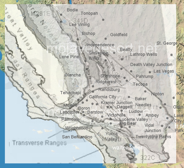
Basin and Range Region
The province is characterized by interior drainage with lakes and playas, and the typical ...
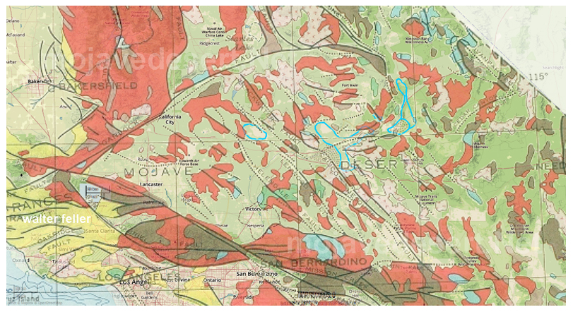
Mojave Block
The Mojave is a broad interior region of isolated mountain ranges separated by expanses of ...
Defining Faults
San Andreas Fault
The presence of the San Andreas fault was brought dramatically to world attention on April 18, 1906, when sudden ...
Garlock Fault
The Garlock Fault is the defining fault between the Mojave Desert and Sierra Nevada, Basin and Range geomorphic provinces. ..
What is a fault?
A fault is a fracture in the crust of the earth along which rocks on one side have moved relative to those on the other side. Most faults are the result of repeated displacements over a long period of time. A fault trace is the line on the earth's surface defining the fault. An active fault is one that has ruptured in the last 11,000 years.
Types of Faults
The three fundamental fault types are normal, reverse, and strike-slip. Normal faults involve a ...
What is "surface rupture" in an earthquake?
Surface rupture occurs when movement on a fault deep within the earth breaks through to the surface. Surface ruptures associated with the 1992 Landers Earthquake, in San Bernardino County, extended for 50 miles with displacements of an inch to 20 feet. Not all earthquakes result in surface rupture. The Loma Prieta Earthquake of 1989 caused major damage in the San Francisco Bay Area but the movement deep in the earth did not break through to the surface.
Fault rupture almost always follows preexisting faults, which are zones of weakness. Rupture may occur suddenly during an earthquake or slowly in the form of fault creep. Sudden displacements are more damaging to structures because they are accompanied by shaking.
Fault creep is the slow rupture of the earth's crust. Examples of creep are well known along the Hayward Fault where it crosses highly developed areas in Contra Costa and Alameda Counties. Although the Hayward Fault ruptured suddenly in the 1868 earthquake, it also exhibits slow surface creep which offsets and deforms curbs, streets, buildings, and other structures that lie on top of the fault.