Hole-in-the-Wall
Hidden violence
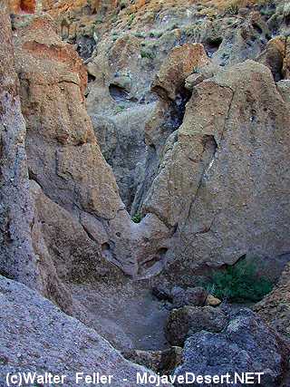
Visitors to Mojave National Preserve are fascinated by the brightly colored, fantastically sculpted rocks at Hole in the Wall. Little do they know that these intricate forms hold the key to a devastating and violent episode in Mojave's geological past.About 18.5 million years ago, a powerful volcanic eruption blasted outward from the nearby Woods Mountains. Propelled by the force of rapidly rising and expanding gasses, a ground-hugging cloud of ash and rock fragments spread out at near super-sonic speeds across the countryside. Some of the rocks thrown out by the blast are 14-20 meters (60 feet) across - the largest ever documented!
Hot, suffocating ash buried every living thing in the path of the blast. An area of over 600 km2 was covered with ash and rock fragments so hot that they welded together after they reached the ground. The toasted and fossilized remains of birds, mammals, and plants lie entombed beneath the volcanic tuff that forms the colorful cliffs of Hole in the Wall.
Woods Mountains volcanic center sputters to life
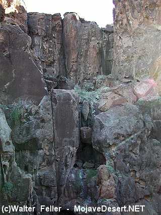
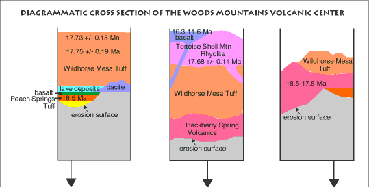
Layer upon layer of volcanic tuff and ash make up the mesas that surround Hole in the Wall.The intriguing volcanic rock formations of Hole in the Wall are but a small remnant of the devastating volcanic episode that began in this region about 18.5 million years ago. Geologist Mike McCurry and others have pieced together evidence that tells the story of this exciting period in Mojave National Preserve.
The first hint of what was to come may have been earth-shaking tremors. As magma made its way from deep in the crust toward the surface it nudges the rock, creating earthquakes. The first magma to reach the surface exploded from several vents. Initial eruptions blanketed the region with up to 200 meters of volcanic flows and tuff. Great masses of sticky (viscous) rhyolite lava oozed up and solidified to form volcanic domes and flows (Hackberry Spring volcanics).
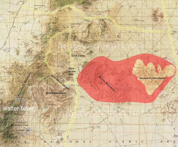
This map shows the first stage of Hole in the Wall volcanic activity. The bright red area shows the original extent of the lava flows and domes that covered the area during this early stage of Hole in the Wall's volcanic history. Much of the rhyolite and tuff have since eroded away, but you can still see rocks of this event in the brown-colored areas shown on the map. Geologists call the entire area within the blast zone, including Hole in the Wall, the Woods Mountains volcanic center.
Although these thick volcanic deposits would have wiped out virtually all life beneath them, they had relatively mild effects compared with what was to come next...
Trapped beneath the surface
By about 17.8 million years ago, the formation of rhyolite domes and flows that marked the first stage of volcanism had ended and the most dramatic and unusual phase of Hole in the Wall's eruptive history was just about to begin. While we usually think of eruptions issuing from a cone-shaped volcano, at Hole in the Wall, the story is quite different.After a brief lull, the intensity of eruptions suddenly escalated. Three major eruptive episodes devastated the region during this second phase. Hidden not far beneath the surface, a mass of magma, crystals, and explosive gasses lay trapped. Over time, pressure within the gas-rich mass steadily increased. Finally the enclosing rock could not withstand the stress and the ground gave way in a horrendous eruptive explosion. Molten lava and huge fragments of rock were hurled upwards. Blocks of the enclosing rock up to 20 meters across were tossed into the air. Hot blocks, globs of lava and glowing ash littered the countryside, falling in thick layers that welded together as they reached the ground.
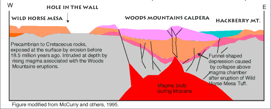
A slice through the Earth at Hole in the Wall. The black lines show where the caldera collapsed along faults. The gray rock represents older Mojave rocks that formed the landscape prior to the eruptions at Hole in the Wall. The brightly colored layers on top are volcanic rocks that flowed across the landscape or fell from the air as a thick blanket of volcanic debris (tephra).
At the site of the eruption, the ground collapsed along numerous faults, forming a huge ring-shaped pit called a caldera. After the collapse lava and volcanic debris (tephra) partially filled the caldera.
It's hard to imagine the intensity of this event. No living thing could have survived within the blast zone. No eruption of comparable violence has occurred in recorded human history.
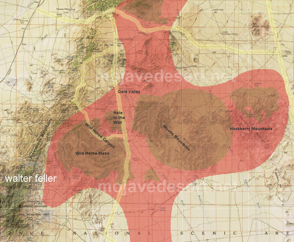
This map shows the most violent stage of Hole in the Wall volcanic activity. The bright red area shows the wide swath of land smothered by lava flows and welded volcanic debris during the second phase of volcanism at Hole in the Wall. Even 17 million years later, much of the original rock produced by this event remains in the brown-colored areas shown on the map. Adapted from McCurry, 1995.
Then, for just a brief time, things quieted down on the surface. Below ground, however, pressure began to build again as more gas and magma collected beneath the caldera.
Twice more, when pressure built up to the point where the ground could no longer contain it, tremendous eruptions, only slightly smaller than the first, rocked the Mojave. Each time, thick layers of glowing volcanic debris decimated the landscape and the original caldera collapsed further.
Woods Mountains volcanic center: The last gasp
The final phase of the volcanic activity that created Hole in the Wall lasted from 17.7 to 17.6 million years ago. Even though this eruptive phase was much more tranquil than the preceding one, its fiery volcanic products once again layed waste to the region.Rhyolite lava flows and thick deposits of solid volcanic debris (tephra) were extruded from the caldera soon after the last phase ended. Rhyolite lava flowed out of vents within the caldera, eventually overflowing the rim. Slow-moving lava lobes spread out out over 3 kilometers beyond the caldera.
During Hole in the Wall's last volcanic gasp, sticky, viscous, masses of rhyolite lava oozed up from the magma chamber below, bowing up the caldera floor. Some of the viscous lava found its way through vents to the surface, where it squeezed up, toothpaste-like, to form bulbous plugs and domes in and near the caldera rim.
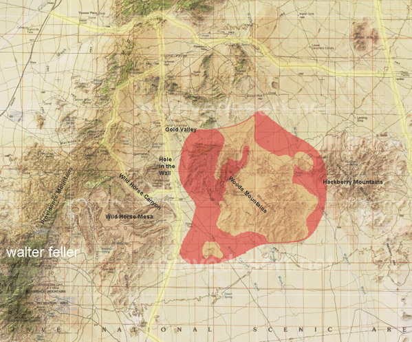
This map shows the phase of volcanic activity at Hole in the Wall. While most of the volcanic tuff you see at this field trip stop was produced by the previous stage of volcanism, right across the road from the National Park Service visitor center you can see the remains of this final eruptive episode. The bright red area shows the original extent of rock produced by the final phase of volcanism at Hole in the Wall. The brown-colored areas shown on the map represent places where rock from this stage remains. Adapted from McCurry, 1995.
Finally, magma that fed Hole in the Wall's eruptions cooled and solidified, plugging its plumbing for good.
Although Hole in the Wall was silenced, just a few million years later a different kind of lava began to make its mark on the Mojave National Preserve landscape at Cinder Cones National Natural Landmark.
source - National Park Service