1604 – Juan de Onate meets the Mohave while seeking a route to the Southern Sea.
1772 – Deserting soldiers from San Diego Mission cross along the north foot of the San Gabriel Mountains; Capt. Pedro Fages pursues.
1776 (March) – Father Francisco Garces travels west along the Mojave River, passing the future Camp Cady site, bound for San Gabriel Mission.
1776 – Spanish explorers pass through what is now southern Nevada.
1810 (May 20) – Padre Francisco Dumetz names the San Bernardino Valley for St. Bernardine of Siena; Politana asistencia established.
1812 – Earthquakes damage Alta California missions; Serrano destroy the Politana chapel.
1819 – Fr. Joaquin Pasqual Nuez with Gabriel Moraga leads punitive expedition; Moraga camps at future Camp Cady.
1826 – Jedediah Smith crosses from the Colorado River to San Bernardino via the Mojave.
1827 – Smith attacked by Mohave on return; ten men killed. Ewing Young’s trappers trouble Mohave villages.
1829 – Rafael Rivera scouts Las Vegas Valley; Antonio Armijo leads caravan to California via Mojave River and Cajon Pass. San Bernardino asistencia rebuilt. Ewing Young and Kit Carson use the trail and camping sites.
1830 (Jan 28) – Armijo’s caravan descends Mojave River to Cajon Pass, fixing the first regular Old Spanish Trail.
1831 – William Wolfskill and George Yount travel the trail.
1832–1834 – Trade expands; missions suffer livestock thefts; caravans increase.
1837 – William Pope and Isaac Slover enter via the North Branch.
1838 – Lorenzo Trujillo and others settle near San Bernardino.
1839–1841 – New Mexican settlers arrive in California; John Rowland and William Workman lead immigrant parties.
1842 – Agua Mansa and Politana communities form.
1843 – Rancho Muscupiabe granted to Michael White (Miguel Blanco).
1844 – Fremont and Kit Carson cross Mojave; Carson and Godey avenge Resting Springs massacre.
1845 – Benjamin Wilson leads posse into San Bernardino Mountains, names Big Bear Valley.
1846 (May 13) – Mexican-American War begins; Californios defeat Kearny at San Pasqual in December.
1847 (Jan 13) – Capitulation of Cahuenga ends fighting in California.
1848 (Jan 24) – Gold discovered at Sutter’s Mill.
1848 (Feb 2) – Treaty of Guadalupe Hidalgo; U.S. acquires California.
1848 – Salt Spring, first recorded gold discovery in San Bernardino County.
1849 – Lost 49ers cross Death Valley. Capt. Jefferson Hunt leads Mormon Battalion members across the Mojave Road.
1850 – California becomes a state. Early gold reported in San Bernardino Mountains.
1851 (June 11) – Mormon colonists arrive in San Bernardino; Hunt brings first Mormon immigrant train. Hunt begins mail service from Mojave River base, lasting three years.
1852 – Mormon lumber road built toward Crestline.
1853 – Lt. Williamson surveys Mojave River; San Bernardino County petitioned.
1854 – Fort Tejon established.
1855 – First gold at Big Bear; Oasis of Mara noted. Mormon missionaries establish Las Vegas fort.
1857 (Jan 9) – Fort Tejon earthquake; San Bernardino disincorporated. Edward F. Beale notes Camp Cady site.
1858 (Jan) – Beale, Mercer, and 45 dragoons march toward the Colorado, passing site of future Camp Cady. Butterfield Overland stages begin service.
1859 (Jan) – Companies B and K, First Dragoons, scout Mojave River. Sept 29, dragoons return to Fort Tejon. Oct 21, Capt. Hancock sends wagon train of supplies via Mojave Road. Oct 29, J. Winston establishes depot at future Camp Cady.
1859 – Bodie, California, discovered by Wakeman S. Bodey.
1860 (Feb 11) – Lt. Col. B. L. Beall sends dragoons from Tejon in search of Indians. (Mar 31) Los Angeles Star calls for military post. (Apr 14) Maj. James Carleton establishes Camp Cady, named for Col. Albemarle Cady. (Apr–Jul) Patrols build redoubts at Soda and Bitter Springs; Carleton recalled to Tejon.
1860 – Coso discovered by Dr. E. Darwin French. Tecopa and Cerro Gordo ores found.
1861 (Jan 29) – Supply train sent to Fort Mojave via Camp Cady. (Apr) Civil War begins.
1861 – White Mountain City established; mining begins in New York Mountains; Sage Land District discovered.
1862 (Jan–Feb) – Floods damage Mojave roads. (Apr 14) Lt. Nathaniel Pierce and detachment briefly garrison Camp Cady.
1862 – Cerro Gordo worked by Mexican miners; Turtle Mountains, Whipple Mountains, and Copper Basin mined.
1863 – Camp not permanently garrisoned; visited by Federal troops.
1863 – Freeman District organized; Irataba copper district formed; Rock Spring silver discovered.
1864 (Jul–Sep) – Capt. John Cremony and Company B, 2nd California Cavalry, patrol Mojave Road from Cady to Rock Springs.
1864 – El Paso Mining District active.
1865 (Apr 23) – Official establishment date of Camp Cady. Rotations of California Infantry and Cavalry serve. Pvt. Somerindyke dies by accident; Elliot Coues visits in November.
1865 – Cerro Gordo revived by Coso miners; Tecopa developed; Bullion Mine in Ivanpah discovered.
1866 (Jan) – Capt. Benjamin West commended for building work. (Jul 29) Skirmish near Mojave kills several soldiers.
1866 – Anthony Mill Ruins noted.
1867 (Feb–Aug) – Lt. Manuel Eyre commands Camp Cady; Indian fights at Marl Springs and Pahute Springs. Store at camp burned; Eyre dismissed in 1866.
1868 (Oct 6) – Old site abandoned; new Camp Cady built half a mile west with permanent adobe buildings.
1868 – Clark Mountain copper discovery.
1870 (Oct 19) – Gen. Stoneman designates Camp Cady a military reservation.
1870 – Darwin rediscovered; Avawatz area named.
1871 (Mar) – Camp Cady abandoned; property turned over to local stockmen.
1871 – Chloride Cliff ore discovered.
1872 – Oro Grande/Silver Mountain district organized.
1873 – Old Woman Mountains discovery; Twentynine Palms finds; Panamint boom.
1874 – Darwin silver-lead bodies located.
1874–76 – Southern Pacific completes Tehachapi Loop, connecting San Francisco to Los Angeles.
1875 – Savahia Peak, Exchequer, Waterman, and Riggs mines discovered.
1876 – Ord and Fry Mountains claims located; Lookout district silver-lead discovered.
1877 – Wildrose kilns operate; Beveridge district mined.
1879 – George G. Lee dies, linked to Calico discovery.
1880 – Providence Bonanza King silver discovered; Nantan mine located.
1881 – SP builds Mojave to Calico Station. Harmony Borax Works founded; Calico camp grows; Alvord Mine consolidated.
1882–83 – SP extends track to Needles.
1882 – Providence Mountains gold-iron ores.
1883 – Atlantic & Pacific builds to Kingman; Carson & Colorado reaches Keeler. Needles Reduction Works opens; Ballarat’s Panamint Valley Mine located.
1883 (Aug 21) – Machinery for Alvord Mill delivered to Camp Cady.
1884 – A&P crosses Colorado River and acquires SP line Waterman Junction to Needles. Kramer siding established.
1884 (Jul 5) – President Arthur declares Camp Cady useless for military purposes.
1888 – Paradise Mine discovered.
1890 – Vanderbilt gold discovered by Bob Black.
1893 – Nevada Southern links Goffs to Manvel/Barnwell. Lost Horse Mine established in Joshua Tree region.
1895 – California Eastern begins service.
1897 – Stone Hammer and Orange Blossom mines discovered.
1898 – Randsburg Railway opens. Bagdad-Chase gold discovered; Copper City and Goldstone developed.
1899 – Rosalie post office moved from Ivanpah.
1900 – Coolgardie placers found.
1902 – Ludlow & Southern and Barnwell & Searchlight railroads built. Halloran Spring mines recorded.
1903 – Keane Wonder Mine discovered.
1904 – Tonopah & Tidewater Railroad opens. Rhyolite, Nevada founded.
1905 – San Pedro, Los Angeles & Salt Lake Railroad completed; Tonopah & Goldfield Railroad opens. Inyo Mine developed; Leadfield begins; turquoise discovered at Halloran Spring.
1906 – Las Vegas & Tonopah Railroad built. Skidoo founded; Goldbend and Death Valley Mine discovered. Albert Johnson and Walter Scott make first trip to Death Valley.
1906–1922 – Johnson and Scotty visit Death Valley intermittently.
1907 – Bullfrog Goldfield connects Nevada camps. Garvanza Mine; Hart boomtown founded; Gold Belt discovered.
1908–10 – Arizona & California line links Cadiz, Rice, and Parker. 1908 – Gold Valley discovery.
1909 – Gypsite discovered at Koehn Dry Lake.
1910 – Slocum and Opal camps founded.
1911 – Silver Lake talc mines opened; Saltdale noted.
1912 – Southern Pacific builds Jawbone Branch to Owens Valley.
1913 – Trona Railway opens. Clipper Mountains discovery.
1915–16 – California Southern (II) built between Rice and Ripley. Crutts mining camp appears.
1915–1917 – Johnson acquires ranches in Grapevine Canyon, names them Death Valley Ranch.
1921 – Johnson plans permanent structures. Eichbaum opens Towne Pass toll road.
1922 – Johnson hires Frederick Kropf as superintendent.
1922–1924 – Garage, main house, cookhouse built.
1924–1925 – Stables, chicken coop, workshop built.
1925 – Matt Roy Thompson hired.
1925–1926 – Commissary constructed.
1926–1931 – Architect MacNeilledge designs Spanish-style complex, replaced by de Dubovay in 1931.
1927 – U.S. Borax opens Furnace Creek Inn.
1929 – Dewey Kruckeberg landscapes Death Valley Ranch.
1930 – Hoover withdraws land for study; Johnson learns surveys flawed. Eichbaum completes road to Grapevine Canyon. Tourist traffic increases.
1930–1931 – Daily visitors range from 40 to 100 during construction.
1931 – Johnson halts construction over title issues.
1933 (Feb 11) – Hoover proclaims Death Valley National Monument. Johnsons move to Hollywood, visit monthly.
1934 – Johnson opens informal public tours; Burton Frasher postcards produced.
1935 (Aug 22) – Roosevelt allows Johnson to repurchase Grapevine Canyon land.
1936–1937 – Formal tours begin, $1 admission. Bessie Johnson manages.
1937 (Nov 17) – Johnson receives land patent.
1938 (Mar) – Flood washes away last traces of Camp Cady.
1941 (Oct) – Bessie Johnson publishes 10,000 castle guidebooks.
1942–1945 – WWII rationing reduces castle visitation.
1943 (Apr 22) – Bessie Johnson dies in auto accident on Towne Pass.
1946 – Johnson creates the Gospel Foundation.
1947 (May 19) – Johnson wills property to Gospel Foundation.
1948 (Jan 7) – Johnson dies; Foundation continues operating castle as “museum-hotel.”
1970 (Jul) – NPS purchases Grapevine ranches and castle for $850,000; furnishings donated.
1970–1973 – National Parks Concessions administers castle tours and upkeep.
1973 – NPS assumes full responsibility for Scotty’s Castle.
Month: September 2025
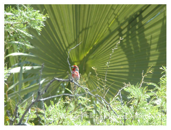
House Finches Living Outside
Something you can explain to a 7-year-old
A long time ago, house finches lived only in the western United States and Mexico. They were small, cheerful birds. The males wore bright red feathers, while the females blended in with soft browns. People loved hearing their songs in backyards and towns.
In the 1940s, some sellers decided to trap these birds and bring them east. They thought people in New York would buy them as pets if they gave them a fancy name. So, they called them “Hollywood finches,” as if the birds were little movie stars from California.
At first, people did buy them. However, a new law soon made it illegal to sell wild birds. The sellers didn’t want to get in trouble, so they opened the cages and let the finches go free in the East.
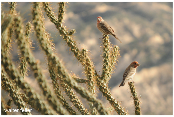
The birds didn’t just survive—they thrived. They built nests on porches and rooftops, sang their songs in city parks, and raised families. Over time, they spread across the East and eventually met up with their western cousins. Today, house finches live almost everywhere in the United States.
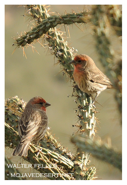
So the next time you hear a happy chirp in your neighborhood, remember: that little bird might be the great-great-grandchild of one of those “Hollywood finches” who escaped their cages and made a brand-new life.
They’re called house finches because they like to live near people and their homes.
Unlike some shy birds that stay deep in the forest, house finches are very comfortable around neighborhoods. They often build their nests on porches, in hanging flowerpots, or in the nooks and crannies of houses and buildings. People would see them perched on rooftops or windowsills, singing their cheerful songs, and so the name “house finch” stuck.
So the name really means “a finch that likes living around houses.”
Where Lizards Live
Something for a Seven-Year-Old
a straight, clear explanation for a 7-year-old:
So, a lizard’s home isn’t a building—
Lizards in the desert have some clever ways of finding homes. They don’t live in houses like people do, but they find spots that keep them safe from the hot sun and from hungry animals. Many lizards dig little burrows in the sand or dirt where it’s cooler. Others hide under rocks, inside cracks, or even in bushes.

During the hottest part of the day, they often stay hidden in these safe spots. When it’s cooler in the morning or evening, they come out to run around, eat bugs, or warm up by lying on sunny rocks.
So, a desert lizard’s “house” could be a hole in the ground, a shady bush, or even a crack in a boulder—it’s wherever they can stay safe and comfortable.
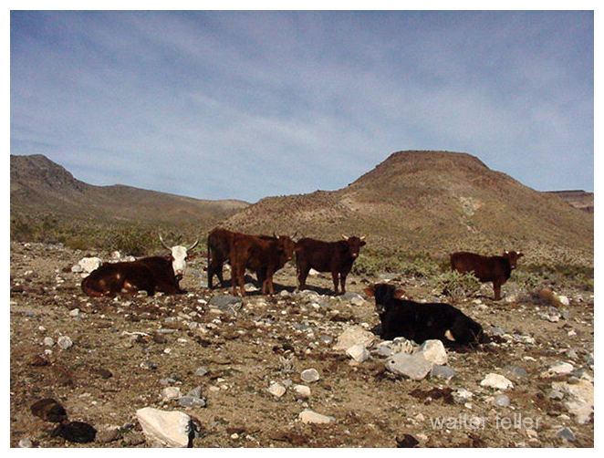
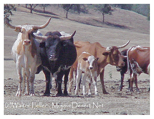
Men, Cattle & Cattlemen
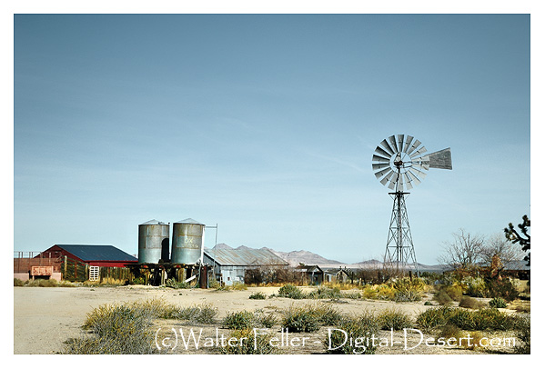
Raising cattle in the Mojave National Preserve comes with unique challenges and a long history. The area has been home to cattle ranching since the late 19th century, with ranchers taking advantage of the sparse but hardy desert vegetation and natural springs.
Historical Perspective
Cattle ranching in the Mojave Preserve dates back to the late 1800s, with ranchers establishing homesteads and using the land for grazing. Ranches like Rock Spring Ranch, Valley View Ranch, and the OX Ranch were some of the key operations. Water was always the limiting factor, so early ranchers developed wells, windmills, and water troughs to sustain their herds.
During the 20th century, ranching continued despite the harsh environment. The Bureau of Land Management (BLM) and later the National Park Service (NPS) managed grazing leases. Still, conflicts arose over land use, conservation, and the impact of cattle on fragile desert ecosystems.
Modern Challenges
After the creation of the Mojave National Preserve in 1994, the National Park Service began phasing out cattle ranching through voluntary buyouts of grazing rights. Some ranchers chose to sell, while others held on under special agreements. Today, very few cattle operations remain in the preserve, and grazing is largely restricted.
Key challenges include:
- Water Scarcity: Natural springs and wells are limited, making it difficult to maintain large herds.
- Harsh Climate: Extreme temperatures and unpredictable rainfall mean cattle must be resilient to drought conditions.
- Regulatory Restrictions: The National Park Service enforces conservation policies, restricting new grazing leases and limiting herd sizes.
- Predation and Disease: Coyotes and mountain lions pose risks to cattle, and disease can spread in remote conditions with limited veterinary care.
Legacy and Conservation
Though large-scale ranching has faded chiefly, remnants of the cattle industry remain in the form of historic ranch sites, windmills, and abandoned corrals scattered throughout the preserve. Some former ranching areas have become part of conservation efforts to restore native plant life and protect desert ecosystems.
Ranching played a significant role in shaping the human history of the Mojave, but in many areas, the land is slowly returning to a more natural state.
Mojave Preserve
Ranches in the Preserve
Desert Ranches
Trona
Trona: The Mineral and the Lake That Made It Famous
When people hear the word “Trona,” they might think first of the tiny desert town in California’s Searles Valley. But long before there was a town, there was a mineral—trona itself—and long before that, there was a great Ice Age lake that left behind an astonishing chemical treasure chest. This is the story of the mineral, the lake, and the wider desert world it belongs to.
The Mineral Trona
Trona is a sodium carbonate mineral with the chemical formula Na3(CO3)(HCO3)·2H2O. At first glance, it doesn’t look impressive—grayish, sometimes yellowish, dull and earthy in texture. You can scratch it with a fingernail, since it ranks only 2.5 on the Mohs scale. But appearances deceive. Trona is the raw material that fuels the soda ash industry, and soda ash in turn is essential for making glass, detergents, paper, and countless industrial products.
Trona forms in dry, alkaline lakes where evaporation pulls water away and leaves dissolved salts behind. In crystal form, it can be fibrous, granular, or massive, and it’s often found alongside related salts like nahcolite, gaylussite, and halite. It belongs to the evaporite family—minerals that crystallize in the desert sun as lakes vanish.
Trona’s Desert Cousins
To understand trona, you have to meet its “cousins.” Borax, another evaporite mineral, forms in highly alkaline, boron-rich lakes. Borax is white and powdery, long known for its role in glassmaking and cleaning products, and it gained fame during the “20 Mule Team” borax days of Death Valley. Hanksite, a rare mineral found almost exclusively in Searles Lake, is more exotic. With its strange mix of carbonate, sulfate, and chloride, it grows in large hexagonal crystals prized by collectors. Thenardite, a sodium sulfate, appears later in the drying sequence, often after trona has already crystallized. And halite—plain rock salt—is the final curtain call in the evaporation process, forming thick beds of common salt.
Together, these minerals tell the chemical story of ancient lakes. Each one signals a different stage in the drying cycle: carbonates like trona first, then borates, then sulfates, then chlorides, with rare mixes like hanksite reserved for the most concentrated brines.
The Evaporation Sequence
Picture a great lake in the desert slowly drying under the sun. As water disappears, minerals crystallize out in a sequence. First come the carbonates—trona and nahcolite—as the lake becomes alkaline. If boron is present, borax forms next. With more evaporation, sodium sulfate minerals like thenardite precipitate. Finally, halite—rock salt—deposits in massive beds, and in the last brine stages, unusual combinations like hanksite grow. It’s nature’s chemistry experiment written on the desert floor.
Searles Lake: A Desert Laboratory
Searles Lake in the Mojave Desert is one of the best examples of this process. During the Ice Age, between 30,000 and 12,000 years ago, Searles Lake was a deep freshwater body. Fed by the Mojave River, it was part of a chain of lakes stretching across the desert. When the climate dried, Searles Lake shrank and minerals built up, cycle after cycle, until its bed became one of the richest evaporite deposits on earth.
Today, companies mine Searles Lake for trona, borax, soda ash, sodium sulfate, and halite. They use solution-mining, pumping brines from beneath the playa into evaporation ponds, then refining the salts. The nearby town of Trona, California, owes its name and existence to this mineral wealth. Each October, the community hosts “Gem-O-Rama,” when collectors from around the world flock to dig crystals of hanksite, borax, and halite fresh from the brines.
The Mojave River Lake Chain
Searles Lake didn’t exist in isolation. It was one link in a chain of Ice Age lakes connected by the Mojave River. The river began in the San Bernardino Mountains, flowed through the Victor Valley, and filled Lake Manix near Barstow. When Lake Manix spilled north through Afton Canyon, water reached Soda and Silver Lakes, forming Lake Mojave. In the wettest periods, Lake Mojave overflowed into Searles Lake. From there, water sometimes spilled farther into Panamint Valley, filling Panamint Lake. In the very wettest times, the chain reached all the way to Death Valley, where Lake Manly stretched 80 miles long and hundreds of feet deep.
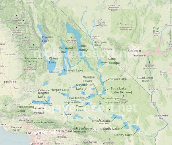
This chain acted like a conveyor belt for water and minerals. Each basin concentrated dissolved salts, but Searles Lake, being closed and rarely flushed, became a perfect trap. That is why its sediments are so rich in trona and other evaporites.
From Ice Age to Industry
When the Ice Age ended, about 12,000 years ago, the climate warmed, and the Mojave River carried far less water. Searles Lake dried into a playa, but its mineral layers remained. By the 1800s, prospectors discovered borax there. In 1873, John and Dennis Searles began mining borax with mule teams, one of the earliest borax operations in California. By the early 1900s, large-scale industrial mining was underway, and the town of Trona was established to house workers. Throughout the 20th century, operations expanded with new methods, and today the lake continues to support a thriving industry and a small desert community.
A Legacy Written in Salt
Searles Lake is more than a dry playa; it is a book of climate history, a record of ancient rivers, and a living source of industrial minerals. The mineral trona, dull to look at but essential to modern life, is both its namesake and its most important product. In the larger story of the desert, Searles Lake shows how geology, chemistry, and human enterprise meet in one stark basin. From Ice Age waters to the shelves of today’s stores, trona’s journey is a desert tale written in crystal layers.
–
Not Rattlesnakes
Out in the desert, most folks listen for the rattle-rattle warning of a rattlesnake. But did you know many other snakes are sharing the sand and rocks?
One day, a little Gopher Snake slithered by a farmer’s field. “Don’t worry,” it said, “I don’t bite like a rattler. I eat the mice sneaking into your grain.” And with that, it slipped into a hole and came out with a squeaking snack.
“Eeep, eeep, eep,” the vulnerable little mouse cried as it was manipulated headfirst into the snake’s mouth. Its cries muffled as the swallowing began. I have heard it said that going with the nap of the fur aids more efficient digestion.
A shiny Kingsnake stretched out in the sun. “Guess what I like to eat?” it grinned. “Other snakes—even rattlesnakes! Their venom doesn’t bother me one bit.” The rattler kept its distance.
Old Kingsnake had plenty of holes in his head and along his body to prove that he was immune to the rattlesnake bites.
Meanwhile, a Coachwhip zipped across the desert floor, faster than a kid on a bike, chasing lizards like a ribbon in the wind. And deep in the rocks, a Rosy Boa curled up, soft and calm, looking more like a coiled rope than a wild snake.
Every snake has its place, and while rattlesnakes warn with a rattle, the others work quietly to keep the desert in balance. So remember: not all snakes are scary—some are helpers too.
Lizard Stuff
Something for a Seven-Year-Old
Out in the desert, you might see a lizard on a rock doing tiny push-ups. It looks funny, but for lizards it is very serious.
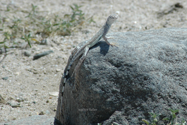
One reason is to warn other lizards: “This is my spot—stay away!” The push-ups are like flexing muscles, showing strength without actually fighting. If another male sees it, he knows the rock is already claimed.
Another reason is to attract attention. When a female lizard comes around, the male does even more push-ups, faster and stronger. Sometimes he flashes bright colors on his throat or belly while he moves. It is his way of saying, “Look how tough and healthy I am. Don’t you want to pick me?”
And there is a bonus reason: on cool desert mornings, push-ups help a lizard wake up and get his blood moving, almost like warm-up exercises before the day begins.
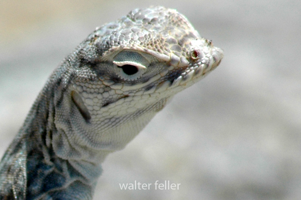
So those little desert push-ups are not just exercise. They are lizard language—part warning, part love song, and part morning workout.
The Archive and the Conversation
A Living Record
The Mojave Desert is the central thread, but the archive is more than just a storehouse of facts about the land. It’s a layered record, part historical survey, part natural history guide, and part personal journal. The archive contains thousands of entries, ranging from carefully produced histories of ghost towns to quick, almost casual notes about desert wildflowers. It also includes the memory of conversations, some technical, some reflective, all contributing to a living body of knowledge.
The current archive carries these notes forward. They do not simply add new entries; they revisit and renew older ones. When you ask about Scotty’s Castle, it’s not only a summary of a landmark in Death Valley but also a chance to look again at Walter Scott’s fabricated gold mine, his staged shootout at Wingate Pass, and the way his friendship with Albert Johnson turned into one of the strangest desert partnerships. That reflects the way your archive works: history is never sealed off, but constantly connected to other stories. Scotty’s fake mine ties to mining history, con men, railroad investors, and the enduring myths of the desert.
Other chats anchor themselves in place. Marl Springs, for example, appears not just as a dot along the Mojave Road but as a critical water source, garrisoned by soldiers in 1867 and attacked in the same year. The description in your archive emphasizes its clay-like soil and its dependable, if limited, water supply. The chat adds motion to that entry by pulling the soldiers into view, by describing how isolated Marl Springs was from Soda Springs to the west, and by noting how wildlife still depend on its water. Here, the archive preserves detail, while the conversation reanimates it.
Afton Canyon is another recurring subject. The archive refers to it as the Grand Canyon of the Mojave, formed approximately 15,000 years ago when Lake Manix drained catastrophically. The chats bring it alive with more than geology. They highlight the Mojave River flowing above ground, the slot canyons and caves, the risks of flash floods, and the chance to hike and watch wildlife. The personal tone slips in here: Afton is not just an entry on a map; it is a place walked, seen, and photographed. This blend of technical and personal is one of the hallmarks of your work.
Rainbow Basin provides another good example. In the archive, it is a geologic site featuring badlands and folded rock, as well as paleontological finds and fragile soils. In conversation, it becomes a vivid picture of color bands, rattlesnakes, and the eerie feel of hiking through formations shaped by time and water. The description is simplified for younger readers when needed, but the detail remains. It is both a science lesson and a story about walking through the basin yourself.
The archive also gives weight to local communities and their histories. Cajon Pass, for instance, is not simply a route. It is a crossroads layered with stories: Rancho Muscupiabe, Mormon pioneers, the Santa Fe and Southern Pacific railroads, the old wagon roads, the geology of Lost Lake and Blue Cut. Chats about Cajon Pass often focus on its function as a gateway, a place where history, geology, and transportation come together. They show how the archive not only stores information but also draws connections, creating a network of meaning.
The same goes for Old Woman Springs. The archive notes its name, given by surveyors who saw Indian women there. It records Albert Swarthout’s ranching operation, the cattle drives through Rattlesnake Canyon, and the later disputes with J. Dale Gentry. In chat, the place becomes more than history. It becomes a story of how ranching shaped the Mojave, how land ownership shifted, and how the desert landscape still carries those traces.
Other places appear again and again, sometimes as historical notes, sometimes as subjects for simplified explanations. Shea’s Castle in the Antelope Valley, built by Richard Shea in hopes of curing his wife’s illness, ruined by the stock market crash, later a film set. Hotel Beale in Kingman is tied to Andy Devine, the actor whose name became linked to Route 66. Oasis of Mara in Twentynine Palms is a site of Native planting, early settlement, and eventual park development. Each of these places carries weight in the archive, but they come alive in conversation, as the details are retold, refined, and made accessible.
Ecology is just as present as history. Pinyon pines and junipers, Fremont cottonwoods, brittlebush, desert sunflowers, bees sleeping in flowers, and ‘horny toads’ explained to children — all of these details show how the archive ranges across subjects. A glossary entry on igneous rocks can sit beside a playful description of bees tucked into golden blossoms for the night. A technical note on pinyon-juniper woodland succession can be followed by a casual story about antelope ground squirrels darting through camp. These shifts in tone are part of the richness of the record.
The archive also holds larger arcs. The history of Owens Valley runs through it: the water conflicts with Los Angeles, the aqueduct, the treaties with Native peoples, the battles fought during the Owens Valley Indian War. Panamint City and Greenwater appear as examples of boom and bust, with detailed accounts of stagecoach robbers, Nevada senators, mining camps, and the short-lived hopes of investors. The Tonopah and Tidewater Railroad, Remi Nadeau’s freight road, and the Atlantic and Pacific’s push across the Mojave all weave together into the bigger story of transportation. These arcs show how your archive is not just about single places but about the way places link into broader regional histories.
The present chats extend these arcs. A question about Owenyo might focus on its railroad history, but in doing so, it links back into Owens Valley and forward into the decline of rail in the desert. A question about Llano del Rio touches both the socialist dreams of Job Harriman and the modern ruin that still draws visitors. Each chat is both a piece in itself and a way of extending the larger web.
Throughout, there is an awareness of presentation. The archive is not simply a private notebook. It is shaped to be shared: titles, descriptions, metadata, glossaries, indexes. Chats often focus on how best to present this material to readers, whether as timelines, simplified summaries, or relational indexes. The act of shaping the material for public use is part of the archive itself.
The combination of archive and chat also reflects a deeper concern: preservation. The desert is full of forgotten places, and people who once told their stories are no longer around. By recording these histories, revisiting them, and reshaping them for new audiences, the archive resists that loss. The chats show the urgency of this work, as you reflect on volunteers thinning out, museums struggling, and the need to keep the desert’s stories alive.
The archive is a landscape in itself. Its mesas are the long, detailed histories. Its washes are the short, playful notes. Its valleys are the connections between subjects. The chats are the weather moving across that landscape, stirring it, reshaping it, sometimes eroding, sometimes depositing. Over time, the whole thing grows richer, more interconnected, more alive.
This is why the archive and chats cannot be separated. The archive preserves. The chats enliven. Together they form a record of both the desert and of the act of remembering. The Mojave is the subject, but the deeper theme is persistence: the persistence of asking, recording, and shaping knowledge into something that lasts.
–
Beale Hotel, Kingman, AZ.
Tales from the front desk at the Beale
The Hotel Beale opened in 1899 in Kingman, Arizona, after an earlier wooden inn on the site burned down. For a growing railroad town on the edge of the desert, the Beale was a symbol of permanence: solid brick walls, rooms for travelers, and a touch of style on Front Street.
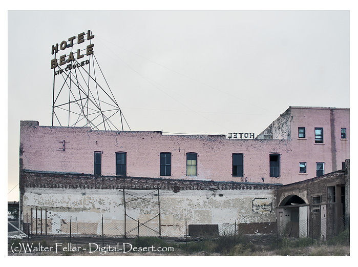
In 1906, Tom Devine, an Irish immigrant and businessman, bought the hotel. He expanded and remodeled it about a decade later, turning it into the finest lodging in Kingman. Travelers arriving by train or, later, by automobile along the developing Route 66 found the Beale a natural stop. It was a place where deals were made, stories were traded, and the town’s social life often centered.
Tom’s son, Andy Devine, grew up right there in the hotel. Born in 1905, Andy spent his childhood surrounded by railroad workers, cowboys, ranchers, and wanderers who drifted through Kingman. Living in that atmosphere of tall tales and wide-open West likely planted the seeds for his later career. Andy eventually headed west to Hollywood, where he became a beloved actor. With his trademark raspy voice and big-hearted, comic presence, he starred in hundreds of films, often as the sidekick in Westerns with John Wayne and Roy Rogers. He also became a fixture on radio and television, hosting shows that made him a household name. Despite his fame, Andy’s roots in Kingman were never forgotten. Locals proudly remembered him as the boy from the Beale.
For decades, the hotel thrived. It welcomed railroad passengers, Route 66 travelers, and even celebrities. But when Interstate 40 bypassed downtown Kingman, business declined. Modern motels popped up along the new highway, leaving the old Beale behind. The once-grand building eventually closed its doors and slipped into disrepair.
Today, the Hotel Beale stands boarded up and weathered, a tarnished landmark on Route 66. Yet it still carries the weight of history: the vision of Tom Devine, the laughter of guests who passed through, and the childhood of Andy Devine, who carried the spirit of Kingman all the way to Hollywood. Restoration groups and investors have shown interest in reviving it, seeing not just a crumbling building but a chance to honor both the town’s history and its most famous son.
The Hotel Beale’s story is one of boom, bust, and memory. It rose with the railroad, declined with the highway, and lives on in the legend of Andy Devine.
Kingman, Az.
Route 66
Santa Fe
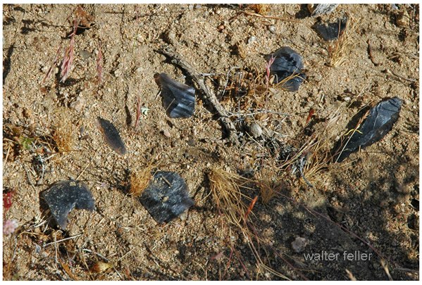
Lithic Scatters, Debitage and Flakes
Here is the difference in plain terms:
- Lithic scatters
These are the sites you see on the ground: clusters or spreads of stone fragments left behind from stone toolmaking. A lithic scatter could include flakes, cores, broken tools, or other debris. It is the visible archaeological footprint of tool production or use. - Debitage
This is the waste material created when someone was shaping stone into tools. Think of the wood shavings on the floor after whittling. Debitage includes flakes, chips, and fragments that were not intended to be used as finished tools. Archaeologists study debitage to determine what kind of tools were being made, the techniques used, and sometimes even who was doing the knapping. - Flakes
These are specific pieces of stone struck off from a larger stone (a core) during toolmaking. Some flakes are just waste (part of debitage), but others can be shaped further into tools themselves (like scrapers or blades). So, flakes can be both by-products and usable tools, depending on how they were treated afterward.
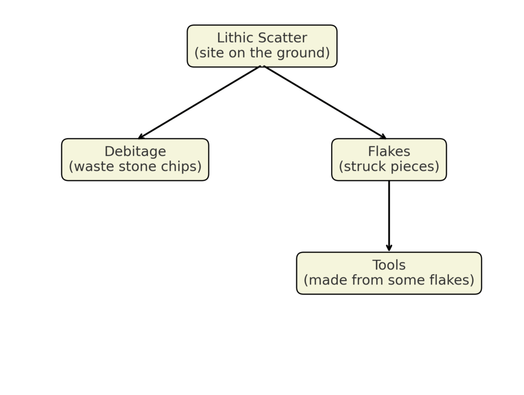
To put it together:
A lithic scatter is the overall archaeological site, which contains debitage (waste pieces) and sometimes flakes (which may be either waste or turned into tools).