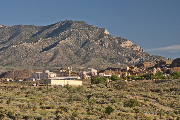
Mountain Pass, California, is an unincorporated community in San Bernardino County near the Nevada border along Interstate 15. It lies on the south flank of the Clark Mountain Range at about 4,730 feet in elevation. Before its transformation into a rare earth mining hub, Mountain Pass was part of a high desert rangeland used for cattle grazing and seasonal travel.
In the late 1800s, ranchers from Ivanpah and the Mojave River region grazed cattle along the area’s sparse grasslands and natural springs. By the early 1900s, a few homesteads, corrals, and line camps appeared, but permanent settlement was limited due to aridity and isolation. The nearest centers of activity were Cima and Ivanpah, tied to the Union Pacific line.
During the 1920s and 1930s, open-range ranching declined as highway construction and mineral exploration expanded. U.S. Highway 91, built through Mountain Pass in the 1930s, connected Barstow and Las Vegas and reshaped movement across the desert. Prospectors began testing local outcrops for copper, fluorspar, and uranium.
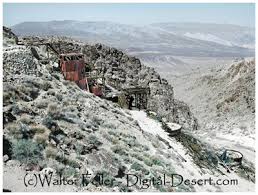
In 1949, while searching for uranium, geologists discovered bastnasite—a mineral rich in rare earth elements. By 1952, Mountain Pass Mine was in production, marking the shift from ranching to mineral extraction. The mine’s bastnasite ore, containing about 7% rare-earth oxides, proved exceptionally rich. Throughout the 1960s, 1970s, and 1980s, Mountain Pass supplied most of the world’s rare earth elements, which are critical for electronics and defense.
Environmental concerns and global competition, particularly from China, led to a decline in the 1990s. A series of wastewater pipeline spills and stricter regulations led to the closure in 2002. Molycorp reopened the site in 2010 but went bankrupt in 2015. MP Materials acquired it in 2017 and restarted production, now emphasizing on-site recycling and domestic refining. Mountain Pass currently produces 10–15 percent of global rare earth supply and remains the only major U.S. operation of its kind.
Timeline:
Late 1800s – Early cattle grazing begins between the Clark and Mescal Ranges. 1890s–1910s – Small ranchers and homesteaders establish corrals and wells near Cima and Ivanpah. 1920s – Ranching continues; U.S. Highway 91 construction increases access. 1930s–1940s – Grazing declines; mineral prospecting grows. 1949 – Bastnasite discovered while prospecting for uranium. 1952 – Mountain Pass Mine begins rare earth production. 1960s–1980s – Peak years; mine supplies most of the world’s rare earth elements. 1980s–1990s – Environmental issues and foreign competition led to a decline. 2002 – Mine ceases operations. 2010 – Molycorp reopens the mine. 2015 – Molycorp declares bankruptcy. 2017 – MP Materials resumes production. 2020s – Expansion of domestic processing and magnet manufacturing.
Mountain Pass stands as a symbol of changing desert economies—from open-range cattle country to strategic mineral industry—each era leaving its own traces: windmills, corrals, and open pits scattered across the Mojave’s high desert plain.
Big Bear, California, began as Yuhaaviatam homeland, later drawing gold seekers, ranchers, and dam builders. From Holcomb Valley’s 1860 rush to a four-season resort, its story blends natural beauty, resource ingenuity, and mountain tradition.
Prehistory • The Big Bear Valley has been inhabited for thousands of years by the Yuhaaviatam (Serrano) people, who live in seasonal villages and call the area “Yuhaaviat,” meaning “Pine Place.”
1845 • Benjamin Davis Wilson leads a posse into the San Bernardino Mountains in pursuit of raiders. The group encounters numerous grizzly bears and kills several, naming the area “Big Bear Valley.”
1850s • Early trappers and cattlemen moved through the San Bernardino Mountains. The valley remains largely remote and unsettled.
1860 • William F. “Bill” Holcomb discovers gold in Holcomb Valley, triggering a rush that brings hundreds of miners and creates mining camps such as Belleville, Union Town, and Clapboard Town.
1861–1862 • The Holcomb Valley boom peaks; San Bernardino County’s population surges. Belleville nearly becomes the county seat but loses to San Bernardino by two votes.
1863–1865 • Decline of the first gold boom as surface gold plays out. Miners leave, and the valley returns to quiet ranching and logging activity.
1870s • Elias J. “Lucky” Baldwin acquires mining claims around Baldwin Lake and forms the Gold Mountain Mining Company. A second wave of mining begins, centered on the Baldwin Mine.
1884 • Frank Elwood Brown, a Redlands citrus grower, constructs the first Bear Valley Dam, a single-arch granite structure. The reservoir created by this dam was named Big Bear Lake.
1890s • Big Bear’s role shifts from mining to recreation. Hunters, anglers, and early tourists begin to visit the mountain lake area. Lodges and cabins start to appear.
1903 • Lower-valley growers formed the Bear Valley Mutual Water Company to manage the reservoir and water rights.
1910–1912 • A new multiple-arch dam, designed by John S. Eastwood, replaces Brown’s dam, raising the lake level by about 20 feet and greatly expanding its capacity.
1920s • Roads improve, and the automobile brings increased tourism. The town of Pineknot develops on the lake’s south shore with lodges, stores, and resorts.
1930s • Winter recreation grows. Early ski runs are cut, and lodges cater to both summer and winter visitors. • 1938 – Pineknot officially changes its name to Big Bear Lake.
1940s • Big Bear becomes a year-round resort. During World War II, mountain roads were used for military transport training, but the area remained largely a recreation destination.
1950s • Big Bear Alpine Zoo opens as a rehabilitation center for injured wildlife (1959). • Ski development accelerates with lifts at Snow Summit.
1960s • Tourism and second-home construction expand rapidly. • The Big Bear Valley Historical Society was founded in 1967.
1970s • The community continues to grow, balancing tourism with environmental concerns.
1980 • The City of Big Bear Lake was incorporated on November 28.
1980s • Alpine Slide at Magic Mountain opens (1983). • Ongoing improvements in highways and infrastructure make Big Bear a popular four-season resort.
1990s • Big Bear becomes known for altitude training by professional athletes, including world-class boxers.
2000s–Present • Tourism, recreation, and environmental stewardship define the region. • The old 1884 dam remains a historical landmark, sometimes visible during low water levels. • Big Bear preserves its mountain-resort heritage while serving as a gateway to the San Bernardino National Forest.
Big Bear and the Digital Desert are closely related through geography, ecology, history, and human development. The Digital Desert’s broader Mojave focus naturally overlaps with Big Bear’s transitional mountain-desert setting in several key ways:
Geographic Connection Big Bear sits at the top of the Santa Ana River watershed, where mountain snowmelt begins the river’s underground journey to Southern California hills and valleys.
Ecological Transition Zone The region bridges montane and desert biomes. Pinyon-juniper woodlands, chaparral, and Joshua tree habitats meet higher-elevation conifer forests. This gradation provides examples of how altitude, temperature, and moisture shape plant and animal communities—central themes within the Digital Desert’s ecological framework.
Historical Ties Figures like William Holcomb and Lucky Baldwin tie Big Bear’s mining story to other desert mineral ventures, including Holcomb Valley’s influence on later Mojave mining booms. Trails from Big Bear connected to routes leading toward Lucerne Valley, Johnson Valley, and beyond—pathways that also appear throughout Mojave Desert exploration and settlement history.
Water and Infrastructure The Bear Valley dams (1884 and 1912) represent early Southern California water engineering that parallels other Digital Desert themes such as aqueducts, irrigation systems, and the transformation of desert hydrology. Big Bear’s water storage directly supported the agricultural valleys below, tying mountain runoff to desert life.
Cultural and Recreational Link Both Big Bear and the Mojave represent frontier landscapes turned into recreation destinations. The same pioneer spirit that shaped desert communities like Apple Valley or Hesperia carried over into Big Bear’s tourism development—cabins, roads, and storytelling built around rugged independence and mountain allure.
Interpretive Relationship Within the Digital Desert framework, Big Bear serves as a high-elevation counterpart—a living case study for water origins, ecological transition, and cultural continuity. It connects the snow-fed headwaters to the dry basins below, showing the mountain-desert system as one continuous, interdependent landscape.
Ecological Description
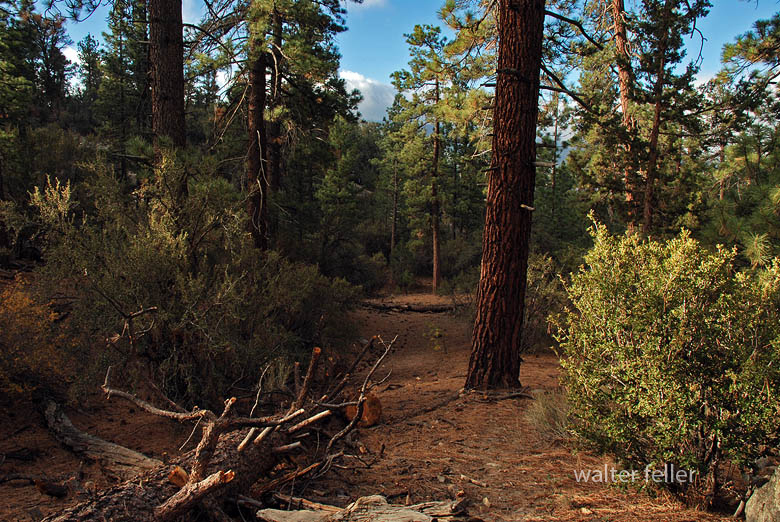
Big Bear Valley lies high in the San Bernardino Mountains, about 6,700 to 7,000 feet above sea level, forming a broad mountain basin surrounded by rugged granite peaks and forested ridges. The valley stretches roughly east–west, framed by Butler Peak and Delamar Mountain to the north, and Sugarloaf Mountain, Gold Mountain, and the San Gorgonio massif to the south and east.
The valley floor is relatively flat, a remnant of ancient glacial and erosional processes, with Big Bear Lake occupying its central depression. Originally a meadowed valley with creeks and marshes, it became a permanent lake after the Bear Valley Dams were built. The soils are derived from decomposed granite, supporting open forests and meadows interspersed with boulder-strewn slopes.
Ponderosa pine, Jeffrey pine, white fir, and incense cedar dominate the higher slopes. At the same time, black oak, manzanita, and chaparral fill the lower edges in sheltered meadows and along streams, willows and alders grow, creating rare wetland habitats for species such as the mountain yellow-legged frog and bald eagle.
The climate is alpine-mediterranean—cold, snowy winters and warm, dry summers—marked by dramatic seasonal shifts. Snowmelt feeds Big Bear Creek and Baldwin Lake, the latter a seasonal alkali flat on the eastern edge of the valley.
Ecologically, Big Bear Valley forms the upper boundary of the Mojave Desert drainage system. It captures mountain precipitation that ultimately seeps underground toward Lucerne and the Mojave River basin, linking the high forest to the desert below.
Timeline References
Big Bear Valley Historical Museum. “History of Big Bear Valley.” Big Bear Valley Historical Society, Big Bear City, CA.
BigBear.com. “Dam: The Creation of Big Bear Lake.” Big Bear Visitors Bureau.
BigBearCabins.com. “About Big Bear: A History.” Big Bear Cabins Travel Guide.
BigBearVacations.com. “A History of Big Bear.” Big Bear Vacations Blog.
San Bernardino County Museum Archives. “Mining and Settlement in the San Bernardino Mountains.”
Eastwood, John S. “The Multiple-Arch Dam of Bear Valley.” Engineering Record, 1912.
U.S. Forest Service. “San Bernardino National Forest: Ecological Subsections and Watershed Overview.”
Bear Valley Mutual Water Company. “Early Development and Water Rights History.”
Langenheim, Jean H., and P. H. Osman. “Vegetation and Ecology of the San Bernardino Mountains.” University of California Publications in Botany, 1959.
California Department of Fish and Wildlife. “Baldwin Lake Ecological Reserve Management Plan.”
San Bernardino Valley Water District. “Hydrologic History of the Bear Valley and Mojave River System.”
Wikipedia contributors. “Big Bear Lake, California.” Wikipedia, The Free Encyclopedia.
Wikipedia contributors. “Big Bear Valley Historical Museum.” Wikipedia, The Free Encyclopedia.
Brown, F. E. “The First Bear Valley Dam and the Redlands Water System.” Redlands Historical Society Papers, 1884–1905.
U.S. Geological Survey. “Geology and Hydrology of the Big Bear Lake Region, San Bernardino County, California.” Professional Paper Series.
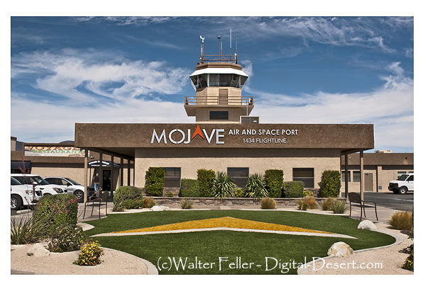
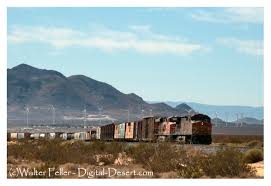
The Mojave Air and Space Port, located in Mojave, California, is a unique and significant facility that plays a crucial role in the aerospace industry. Here’s an expanded look at what makes it a popular attraction and an important center for aerospace activities:
History and Significance
Establishment: Originally established in 1935 as a small rural airfield, the Mojave Air and Space Port has become a major center for aerospace research and development.
Spaceport License: In 2004, it became the first facility in the United States to be licensed as a spaceport, allowing it to conduct spaceflight activities.
Key Features and Attractions
Virgin Galactic’s second SpaceShipTwo vehicle, VSS Unity, soars on its first-ever glide flight on Dec. 3, 2016. (Image credit: Virgin Galactic)
Aerospace Innovation and Companies:
Scaled Composites: the first privately funded spacecraft to reach space, is known for developing innovative aircraft, including SpaceShipOne.
Virgin Galactic: Developing commercial spaceflight services with its SpaceShipTwo spacecraft, aiming to offer suborbital space tourism.
Masten Space Systems: Working on vertical takeoff, landing rockets, and lunar lander technology.
Public Tours and Educational Opportunities:
Guided Tours: The Mojave Air and Space Port offers guided tours that provide insights into the operations of various aerospace companies, the facility’s history, and ongoing projects.
Visitor Center: This center features exhibits on the history of aviation and space exploration, including models and displays of historic and modern aircraft and spacecraft.
Aircraft Storage and Boneyard:
Aircraft Boneyard: The air and spaceport is home to a large aircraft boneyard where retired commercial and military aircraft are stored, maintained, or dismantled for parts. This is a fascinating area for aviation enthusiasts to see a variety of aircraft up close.
Flight Testing and Demonstrations:
Test Flights: The air and spaceport is a premier location for flight testing, with companies conducting regular test flights of new aircraft and spacecraft. Visitors can often witness these test flights, adding to the excitement of the visit.
Air Shows and Events: Periodic air and aerospace events showcase cutting-edge technology and historic aircraft, allowing the public to engage with the aerospace community.
Space Launches and Rocket Testing:
Rocket Engines: Various companies conduct rocket engine testing at the facility, and on occasion, space launches are performed, offering a rare chance to see rocket technology in action.
Experimental Spacecraft: The development and testing of experimental spacecraft, such as those by Virgin Galactic, offer a glimpse into the future of space travel.
Mojave Transportation Museum Foundation:
Historical Exhibits: Dedicated to preserving the rich history of transportation in the Mojave Desert, the museum features exhibits on aviation, railroads, and automotive history in the region.
Educational Programs: The foundation offers educational programs and events to inspire the next generation of engineers, pilots, and aerospace professionals.
Unique Aspects
Climate and Location: The Mojave Desert’s desert climate and wide-open spaces are ideal for aerospace testing and development.
Innovation Hub: The air and space port fosters a culture of innovation, attracting various aerospace companies and startups pushing the boundaries of technology.
Visitor Information
Accessibility: Located just off the main highways, the Mojave Air and Space Port is easily accessible for visitors traveling by car.
Amenities: The facility offers amenities such as a visitor center, dining options, and ample parking.
Future Developments
Expansion Plans: Ongoing expansion and development projects aim to enhance the air and space port’s capabilities, including new hangars, testing facilities, and infrastructure to support increased spaceflight activities.
Commercial Space Travel: As companies like Virgin Galactic move closer to offering commercial space travel, the Mojave Air and Space Port will continue to play a pivotal role in making space tourism a reality.
The Mojave Air and Space Port is not only a hub of aerospace innovation but also a fascinating destination for anyone interested in aviation, space exploration, and cutting-edge technology. Its combination of historical significance, active testing and development, and public accessibility make it a unique and exciting place to visit.
In the Spring of 1925, William M. Dowsing and J. L. Hannan discovered a huge deposit 120 feet (37 m) thick just 1 1/2 miles west of Suckow’s shaft, which they …
3) Go west on State Route 58 through Boron, Mojave, or California City and up to Tehachapi and over the Southern Sierra. 4) Go east to Barstow. There is …
The Copper World Mine, discovered in 1869, was systematically mined in 1898. Ore was smelted west of the mine at Valley Wells. After reduction at the …
This valley is one of nine in California with the same name. This valley sweeps across the western Mojave high desert and includes the communities of Lancaster, …
Sep 27, 2023 … Chemical Composition: Borax is an inorganic compound comprising sodium, boron, oxygen, and water molecules. Its chemical formula is Na2B4O7· …
The population was 3,836 at the 2000 census. The town is located at the northwestern corner of the Mojave Desert, below the Oak Creek Pass. Mojave, Ca …
Boron California. [19][20] The first post office at Boron opened in 1938. History of Borax Mining in … The Twenty Mule Teams hauled more than 20 million …
Desert Fever – Kern County: Kramer District. This district, located some 30 miles east of Mojave, contains the most important source of borax and borate …
State Highway 58 (SR 58) in California, which traverses the Mojave Desert, passes through a range of interesting and diverse points of interest. Here’s a look …
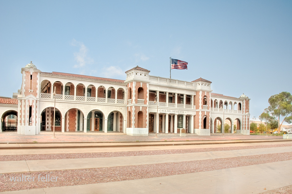
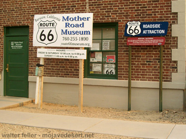
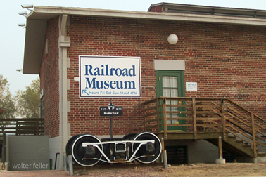
History of Casa del Desierto, Harvey House, Barstow, California
Casa del Desierto
The Casa del Desierto in Barstow, California, is a significant landmark with a rich history, symbolizing the Harvey Houses’ bygone era. In partnership with the Santa Fe Railway, Fred Harvey established a chain of Harvey Houses along the railroad in the late 19th and early 20th centuries. These establishments provided high-quality food and lodging to travelers, revolutionizing railway dining and accommodation in the United States.
The Casa del Desierto, meaning “House of the Desert,” was built in 1911 and is one of the finest examples of the Harvey House establishments. Designed in the Spanish Colonial Revival style, it reflects the architectural elegance and grandeur intended to attract and serve passengers of the Santa Fe Railway. This particular Harvey House played a crucial role in the development of the American Southwest by providing a luxurious stopover for travelers traversing the vast and arid Mojave Desert.
Throughout its operational years, the Casa del Desierto served as a restaurant and hotel and housed the Barstow railroad depot, a Harvey Company retail store, and a telegraph office. It was a vital part of the community and a hub of activity, embodying the spirit of hospitality and the cultural exchange between the East and West.
However, with the decline of railway travel and the rise of automobile transportation, the demand for Harvey House services diminished. The Casa del Desierto closed its doors in the late 20th century and fell into disrepair. Recognizing its historical and architectural significance, efforts were made to preserve and restore the building.
Today, the Casa del Desierto has been repurposed and houses the Barstow Area Chamber of Commerce, the Western America Railroad Museum, and the Route 66 “Mother Road” Museum. It stands as a testament to the vision of Fred Harvey and the importance of the Harvey Houses in American history. It is listed on the National Register of Historic Places, ensuring its preservation for future generations to appreciate the legacy of the Harvey Houses and their impact on travel and culture in the American Southwest.
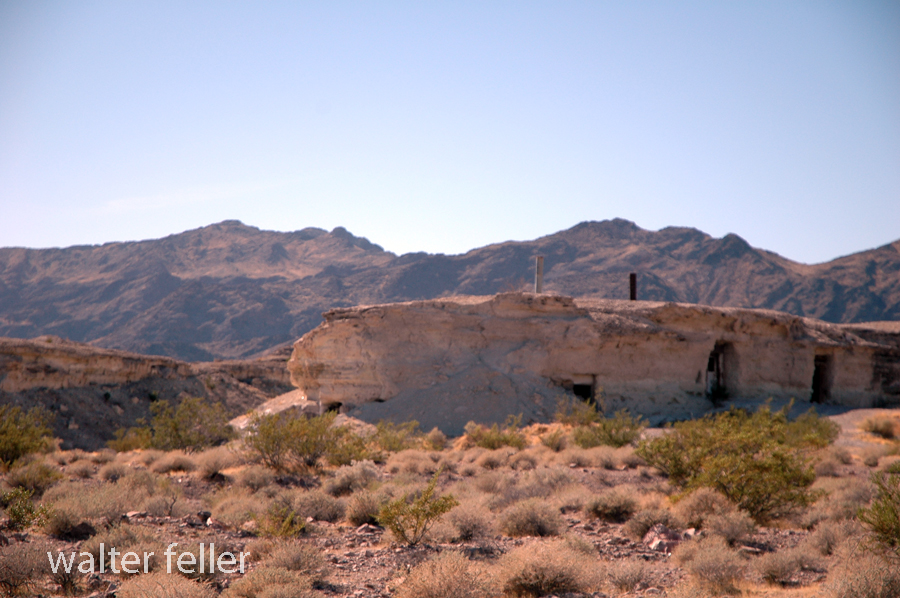
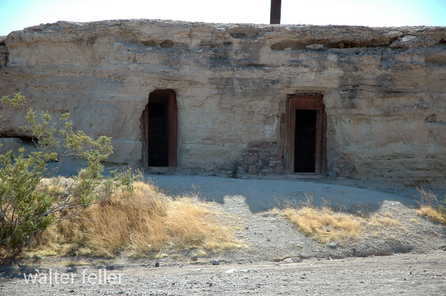
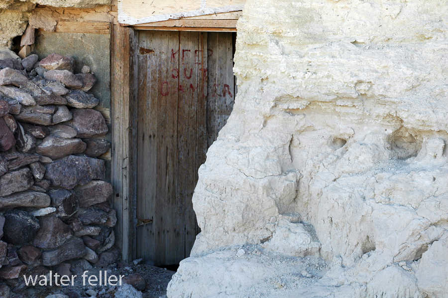
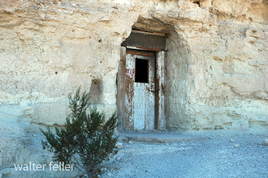
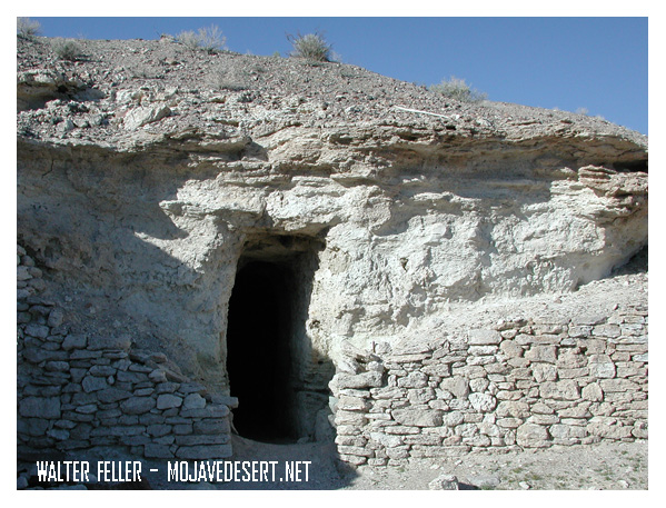
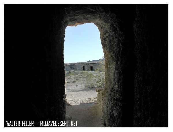
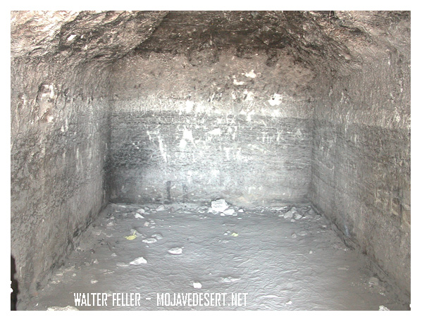
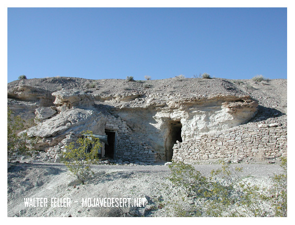
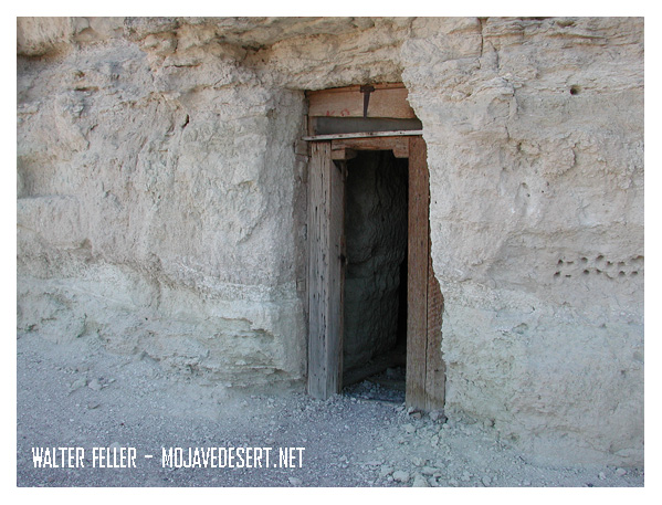
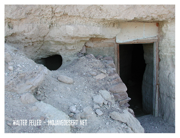
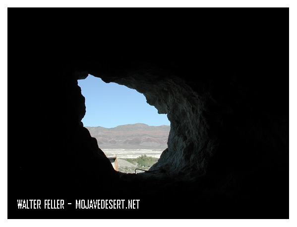
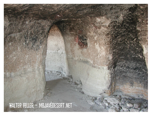
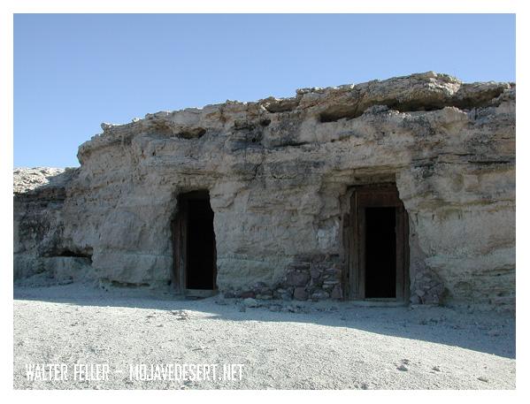
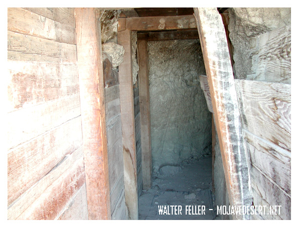
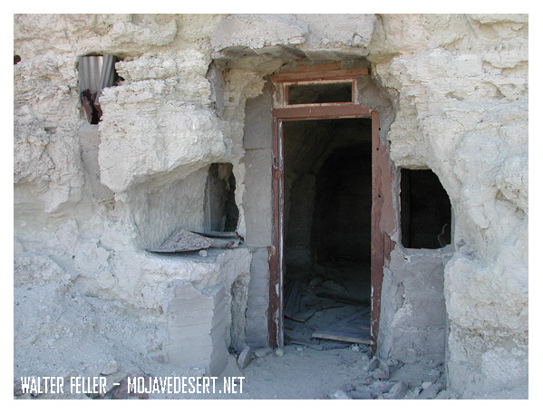
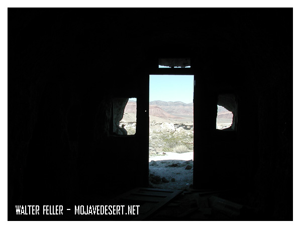
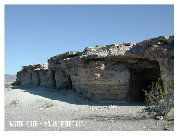
Dublin Gulch in Shoshone, California, is a rich historical site filled with the remains of unique cave dwellings. In the early 1900s, miners and other early settlers dug the caves into soft volcanic ash cliffs. The makeshift shelters protected them against harsh desert weather conditions and extreme temperatures.
These caves were the dwelling place for miners in nearby mines during the early 20th century. Over a certain period, it did take on a kind of community presence. Some of the dwellings even had windows, doors, and chimneys added to them, making them rather homely. Today, Dublin Gulch is a quirky historic site where, among other things, one can see the cave homes and feel what life in the desert must have been like over a century ago.
Dublin Gulch is situated near the small town of Shoshone, one of the important points that both travelers and miners had to pass through in the early 1900s. It lies close to Death Valley and several mining areas. A small piece of history, it offers a glimpse into the rugged, resourceful lives that were lived early on.