Butterfield Overland Stage Mail Route

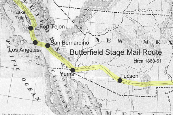
The Butterfield Overland Mail Route was a historic transportation route in the mid-19th century that played a crucial role in connecting the eastern and western parts of the United States.
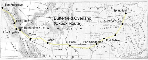
Butterfield Overland Stage Route
(Oxbow Route)

Here are some key points about the Butterfield Overland Mail Route:

  1. Establishment: The Butterfield Overland Mail Company was awarded a government contract in 1857 to establish and operate a stagecoach and mail route between St. Louis, Missouri, and San Francisco, California. The purpose of the route was to improve communication and transportation between the two coasts, especially in light of the California Gold Rush.
  2. Route: The route covered approximately 2,800 miles and passed through eight present-day states: Missouri, Arkansas, Oklahoma, Texas, New Mexico, Arizona, California, and Oregon. It traversed various terrains, including deserts, mountains, and plains.
  3. Frequency and Duration: The Butterfield Overland Mail Company operated its stagecoaches twice a week in each direction, and the journey took about 25 days to complete. This significantly improved travel time compared to other methods available at the time.
  4. Stations and Stops: The company established a series of stations along the route to facilitate the long and arduous journey, spaced about 20-30 miles apart. These stations provided fresh horses, food, and accommodations for passengers and drivers. Some of these stations eventually became important settlements in their own right.
  5. Challenges: The route faced numerous challenges, including harsh weather conditions, difficult terrain, and the threat of attacks from Native American tribes. The company had to implement security measures to protect passengers and mail.
  6. End of Operations: The Butterfield Overland Mail Route faced financial difficulties exacerbated by the onset of the Civil War. 1861, the service was suspended, and the stagecoaches and stations were abandoned. The route became less relevant as the transcontinental railroad was completed after the Civil War, offering faster and more reliable transportation.
  7. Legacy: While the Butterfield Overland Mail Route was relatively short-lived, its legacy persists. The route contributed to the United States’s westward expansion and shaped the development of communities along its path. Some old stations have been preserved as historic sites, and portions of the route have been designated the “Butterfield Overland Mail Route.”

The Butterfield Overland Mail Route remains an important chapter in the history of westward expansion and transportation in the United States during the mid-19th century.

https://mojavedesert.net/stagecoaches/

https://mojavedesert.net/mojave-desert-indians/

https://digital-desert.com/historic-roads/

  1. Butterfield Overland Mail (or Oxbow Route):
    • The Butterfield Overland Mail was a stagecoach and mail delivery service that operated from 1857 to 1861. It was a vital communication and transportation link between the eastern and western United States.
    • The route covered approximately 2,800 miles, connecting St. Louis, Missouri, and San Francisco, California. It passed through several states, including Missouri, Arkansas, Texas, New Mexico, Arizona, and California.
    • The term “Oxbow” might not be directly associated with the Butterfield Overland Mail but could be a local or regional name for a section of the route or a specific location along the way.
  2. Overland Stage Route:
    • The Overland Stage Route, on the other hand, generally refers to the network of stagecoach routes that existed in the western United States during the 19th century. These routes were crucial for mail delivery, transportation of passengers, and freight.
    • The most famous of these stagecoach lines was the Butterfield Overland Mail, but there were other stage lines as well, such as the Central Overland California and Pikes Peak Express Company (C.O.C. & P.P.), which operated a route known as the “Pony Express.”
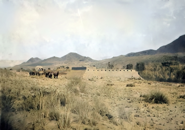
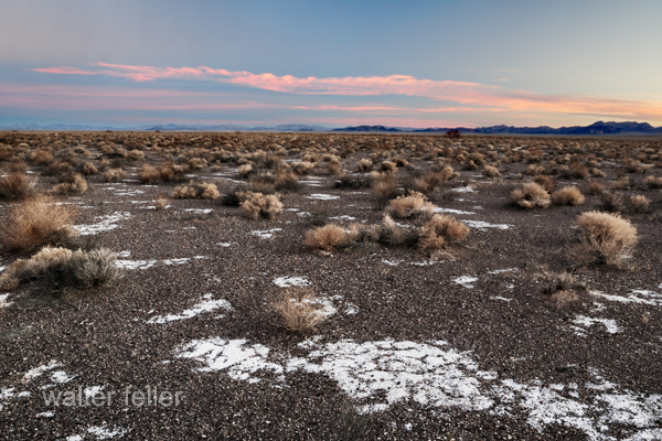
19th Century Military

https://mojavedesert.net/military/

Camp Cady – 1863, Rudolph D’Heureuse

The 19th century was a period of significant expansion and change in the United States, and the military played a crucial role in securing and maintaining control over newly acquired territories. The Mojave Desert was part of this expansion in the southwestern United States. Here are some key points about the military in the Mojave Desert during the 19th century:

  1. Mexican-American War (1846-1848): The Treaty of Guadalupe Hidalgo 1848 ended the Mexican-American War and ceded a large portion of territory, including the Mojave Desert, to the United States. The U.S. Army played a central role in the conquest and occupation of these new territories.
  2. California Gold Rush (1848-1855): The discovery of gold in California in 1848 led to a massive influx of settlers and prospectors. This increased population in the region and the military was tasked with maintaining order, protecting settlers from Native American resistance, and resolving conflicts among different groups.
  3. Mormon Pioneer Expeditions: In the mid-19th century, Mormon pioneers, led by Brigham Young, established a series of settlements in what is now Utah and the surrounding areas, including parts of the Mojave Desert. The military presence was important for maintaining peace and resolving disputes between the settlers and other groups.
  4. Butterfield Overland Mail Route: In the late 1850s, the Butterfield Overland Mail Company established a stagecoach route through the Mojave Desert, connecting the eastern and western coasts. The U.S. Army protected the mail coaches and stations along the route.
  5. Civil War (1861-1865): During the Civil War, many military forces were withdrawn from the western frontier to participate in the conflict. This temporarily reduced the military presence in the Mojave Desert. Additionally, the Confederate Army briefly invaded Arizona and New Mexico territories, which included parts of the Mojave Desert.
  6. Indian Wars: The 19th century saw conflicts between the U.S. military and various Native American tribes in the Mojave Desert region. The military was involved in efforts to control and relocate Native American populations.
  7. Fort Mojave: Established in 1859, Fort Mojave played a significant role in the military’s presence in the Mojave Desert. It served as a base for operations against local Native American tribes and protected settlers and travelers.
  8. Railroad Construction: The late 19th century also saw the construction of railroads through the Mojave Desert. The military played a role in ensuring the security of railroad workers and the transportation of goods.

Overall, the military presence in the Mojave Desert during the 19th century was shaped by the expansion of the United States, the Gold Rush, conflicts with Native American tribes, and the development of transportation routes across the region.

Randsburg Railway

https://mojavedesert.net/railroads/randsburg-railway/

Randsburg Railway refers to a historic narrow-gauge railway that once operated in and around the town of Randsburg, California, in the United States. Randsburg is a small mining town located in the Mojave Desert, and the railway played a significant role in the transportation of minerals and people in the late 19th and early 20th centuries.

The Randsburg Railway was primarily built to serve the mining industry, carrying gold, silver, and other valuable minerals from the mines in the area to nearby processing facilities. The railway also provided a means of transportation for the town’s residents and visitors.

The railway was initially constructed in 1896, connecting Randsburg with the Southern Pacific Railroad at Kramer Junction. The tracks covered about 12 miles and used narrow-gauge equipment. The Southern Pacific Railroad acquired the Randsburg Railway in 1897, and it became part of their system. This connection with the Southern Pacific allowed for the efficient transportation of ore and other goods to wider markets.

Over the years, the mining industry in Randsburg declined, and as a result, the railway’s importance diminished. The line was eventually abandoned in the mid-1930s. Today, Randsburg is a small, historic town that attracts tourists interested in its mining heritage and the remnants of the railway, which can still be seen in the area.

The Randsburg Railway is a part of the rich history of mining and transportation in the American West. It serves as a reminder of the challenges and opportunities that existed in the region during the late 19th and early 20th centuries.

Amargosa Desert

/amargosa/

The Amargosa Desert is a desert in the southwestern United States, primarily in southeastern California and southwestern Nevada. It is part of the larger Mojave Desert region. The term “Amargosa” is Spanish for “bitter,” it may refer to the bitter water found in the area.

One notable feature of the Amargosa Desert is the Amargosa River, which flows through the region. The river is intermittent and often runs underground for significant portions of its course. Sparse vegetation, dunes, and rocky terrain characterize the desert landscape.

The Amargosa Desert is near Death Valley, one of North America’s hottest and driest places. It is a harsh environment with extreme temperatures, especially during summer. Despite its arid nature, the desert supports a variety of plant and animal life adapted to the challenging conditions.

The region is known for its scenic beauty, unique geological formations, and desert landscapes. The Amargosa Opera House and Hotel, located in the town of Death Valley Junction in the Amargosa Desert, is a historic and cultural landmark in the area. Overall, the Amargosa Desert is an interesting and remote part of the desert landscape in the American Southwest.

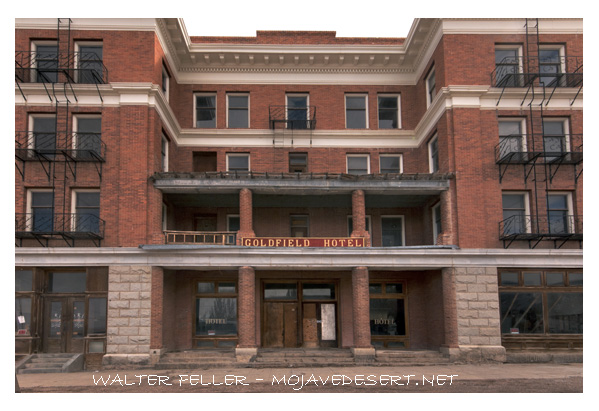
Goldfield Hotel

/goldfield-nv/

The Goldfield Hotel is a historic hotel located in Goldfield, Nevada, USA. Goldfield was a boomtown in the early 20th century, fueled by the discovery of gold in the area in 1902. The Goldfield Hotel was one of the many grand buildings constructed during this time, and it opened its doors in 1908.

The hotel was designed by architect George E. Holesworth and was known for its luxurious accommodations and modern amenities at the time. It boasted features such as an elevator, electric lights, and steam heat. The Goldfield Hotel quickly became a symbol of the prosperity and wealth associated with the gold mining industry.

However, the prosperity of Goldfield was short-lived, as the gold production in the area declined, leading to a population decrease and economic downturn. The hotel closed in 1945, and since then, it has gained a reputation for being haunted. Over the years, various paranormal experiences and stories have been associated with the Goldfield Hotel, contributing to its mystique.

In recent years, efforts have been made to restore and renovate the Goldfield Hotel. The building is a historic landmark and reminds us of the town’s vibrant past. It has also attracted the attention of those interested in paranormal activity and ghost hunting due to its rumored haunted history. The Goldfield Hotel remains an intriguing piece of Nevada’s history and architecture.

Furnace Creek, Death Valley

/furnace-creek-ca/history.html

Furnace Creek is a well-known location in Death Valley National Park in eastern California, USA. It is a popular tourist destination and serves as the primary visitor center for the park. Here are some key points about Furnace Creek:

Location: Furnace Creek is in the heart of Death Valley, one of North America’s hottest and driest places. It’s approximately 190 feet (58 meters) below sea level, making it one of the lowest points in North America.

Visitor Center: The Furnace Creek Visitor Center is a central hub for visitors to the national park. It provides information about the park’s geology, history, and natural features. It’s a starting point for exploring the various attractions within Death Valley.

Climate: Furnace Creek is known for its extreme desert climate, with scorching summer temperatures exceeding 120°F (49°C). Winters are milder but still relatively warm compared to many other regions.

Attractions: Nearby attractions in the Furnace Creek area include Badwater Basin, the lowest point in North America; Zabriskie Point, known for its unique erosional landscape; Artist’s Palette, an area with colorful mineral deposits; and more.

Lodging and Services: Furnace Creek offers lodging options such as the Furnace Creek Inn and Ranch Resort, campgrounds, and restaurants, making it a convenient base for exploring the park.

History: The name “Furnace Creek” reflects the region’s extreme heat. This area has a human settlement and mining history; some historic structures can still be seen nearby.

Furnace Creek is a popular starting point for exploring the natural wonders and unique features of Death Valley National Park. Its striking desert landscapes, geological formations, and harsh conditions make it a remarkable destination for adventurous travelers.

Mormon Fort, Las Vegas, Nevada

https://digital-desert.com/mormon-fort/

The Mormon Fort in Las Vegas, Nevada, is a historic site that holds significance in the region’s history. It is also known as the Old Mormon Fort State Historic Park. The fort represents the birthplace of Las Vegas and is considered the first permanent, non-native settlement in the Las Vegas Valley.

Here are some key points about the Mormon Fort:

  1. Establishment: The fort was established by a group of Mormon missionaries led by William Bringhurst in 1855. They were sent to the area to establish a way station along the Old Spanish Trail.
  2. Purpose: The Mormons built the fort to provide a place for travelers and settlers to rest and replenish supplies as they journeyed through the region. It served as a crucial stop for those traveling between Salt Lake City and Southern California.
  3. Abandonment: Due to conflicts with local Native American tribes and other challenges, the Mormons abandoned the fort in 1857.
  4. Later History: The fort had various uses over the years, including serving as a ranch and a military post. In the early 20th century, efforts were made to preserve and restore the site.
  5. State Historic Park: Today, the Old Mormon Fort is a state historic park managed by the Nevada Division of State Parks. It offers visitors a glimpse into the area’s past, featuring reconstructed adobe buildings and interpretive exhibits.
  6. Location: The Mormon Fort is located in downtown Las Vegas, near the intersection of Las Vegas Boulevard and Washington Avenue.

Visitors to the Mormon Fort can explore the historic structures, learn about the early pioneers who settled in the area, and gain insights into the challenges faced by the original inhabitants. The site provides a contrast to the modern development of Las Vegas and highlights its historical roots.

Old Spanish Trail and Las Vegas

/las-vegas-springs/

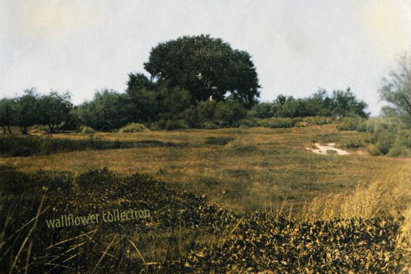
Meadow at Las Vegas Springs


Las Vegas has historical connections to the Old Spanish Trail, which was crucial in developing and expanding trade routes in the American Southwest during the 19th century.

  1. Trade Route Influence: The Old Spanish Trail passed through the general vicinity of what is now Las Vegas. This trail served as a trade route between Santa Fe, New Mexico, and the coastal areas of California. It was used by traders, trappers, and others involved in commerce.
  2. Water Source: Las Vegas, which means “The Meadows” in Spanish, was named after the natural artesian springs in the area. These springs provided a reliable water source for travelers along the Old Spanish Trail, making Las Vegas an important stop for those traversing the harsh desert landscape.
  3. Stopping Point: The springs in the Las Vegas Valley made it a natural stopping point for travelers, providing a place to rest, replenish water supplies, and allow livestock to graze. This contributed to the area’s significance along the Old Spanish Trail.
  4. Connection to Mexican Trade: The Old Spanish Trail was part of the larger system of trade routes that connected Mexico with the western regions of North America. It facilitated the exchange of goods and helped integrate the economies of different regions.
  5. Transition to Modern Era: While the Old Spanish Trail fell out of use with the advent of more direct transportation routes, the presence of reliable water sources continued to make Las Vegas a notable location in the arid landscape of the Southwest.

Today, the historical significance of the Old Spanish Trail is recognized in the region. Efforts have been made to preserve and commemorate parts of the trail, and there is ongoing interest in its history. Having grown from a small oasis in the desert, Las Vegas has transformed into a major metropolitan area. Still, its history as a stopping point along the Old Spanish Trail remains an important part of the region’s heritage.

Travelers and history enthusiasts can explore this connection by visiting historical sites in and around Las Vegas, learning about the Old Spanish Trail’s impact on the area, and appreciating the city’s unique role in the broader context of Western exploration and trade.

Points of Interest in the Mojave

The Mojave Desert, located in the southwestern United States, is known for its unique landscapes and interesting points of interest. Here are some notable places to visit in the Mojave Desert:

  1. Joshua Tree National Park: Famous for its otherworldly Joshua trees, it offers stunning rock formations, hiking trails, and stargazing opportunities. Key attractions include Skull Rock, Hidden Valley, and Keys View.
  2. Death Valley National Park: While part of Death Valley extends into the Mojave Desert, this park is worth mentioning. It’s the hottest and driest national park in the United States. Highlights include Badwater Basin (the lowest point in North America), Dante’s View, and Artist’s Palette.
  3. Red Rock Canyon State Park: Located in the El Paso Mountains, this park features dramatic red rock formations, cliffs, and canyons. It’s a great place for hiking, rock climbing, and photography.
  4. Kelso Dunes: These are large dunes located in the Mojave National Preserve. The dunes can reach heights of up to 650 feet and are known for “singing” or booming when the sand is disturbed.
  5. Mojave National Preserve: This vast area encompasses diverse landscapes, including cinder cone volcanoes, Joshua tree forests, and the Kelso Depot Visitor Center. The preserve offers opportunities for hiking, camping, and exploring old mines.
  6. Calico Ghost Town: A former silver mining town, Calico is now a ghost town restored for tourists. Visitors can explore historic buildings, learn about the town’s history, and experience a taste of the Old West.
  7. Amboy Crater: A volcanic cinder cone in the Mojave Desert, Amboy Crater is a unique geological formation. Visitors can hike to the top for panoramic views of the surrounding desert.
  8. Hole-in-the-Wall: Located in the Mojave National Preserve, Hole-in-the-Wall is known for its unique rock formations, including natural arches and tunnels. There are hiking trails that lead to these formations, providing a chance to explore the area.
  9. Mitchell Caverns: In Providence Mountains State Recreation Area, Mitchell Caverns offers guided tours of limestone caves. The caverns feature stalactites, stalagmites, and other interesting formations.
  10. Lake Mead National Recreation Area: While primarily known for its lakes and water-based activities, it extends into the Mojave Desert. It offers opportunities for boating, fishing, and exploring the desert landscape.

When visiting these places, be sure to check for any updates on accessibility, weather conditions, and park regulations. Additionally, always practice Leave No Trace principles to help preserve the beauty of the desert environment.

Roads West

Mojave Road and Beale’s Wagon Road are historic routes in the southwestern United States, particularly in the Mojave Desert region. Here’s some information about each:

  1. Mojave Road:
    • The Mojave Road is a historic trail that traverses California’s Mojave Desert. It was a significant route used by Native Americans, Spanish missionaries, and later by American pioneers and traders.
    • The trail is approximately 138 miles long and extends from the Colorado River near present-day Needles, California, to the Mojave River near present-day Barstow, California.
    • It was primarily used for transportation and trade between the Colorado River and the coastal settlements in California. The trail passes through varied desert landscapes, including sandy stretches, rocky terrain, and mountainous areas.
  2. Beale’s Wagon Road:
    • Beale’s Wagon Road, named after Edward F. Beale, a military officer and explorer, was a trail developed in the 19th century for the U.S. Army to improve communication and transportation across the arid lands of the American Southwest.
    • Edward F. Beale surveyed and established the road in the late 1850s. The road ran from Fort Defiance in Arizona to the Colorado River, passing through present-day Arizona and California.
    • Beale’s Wagon Road was designed to be more reliable and accessible than other trails, facilitating military movement and communication between California and the western territories.

Mojave Road and Beale’s Wagon Road were important in the United States’ westward expansion. Today, these routes attract history enthusiasts, adventurers, and off-road enthusiasts who explore them to experience the challenges faced by those who traveled these paths in the past. Keep in mind that conditions and accessibility of these trails may vary, so it’s important to check for current information and any regulations before embarking on a journey along these historic routes.