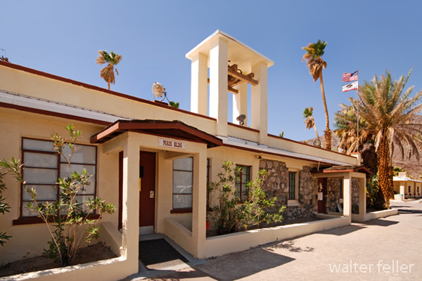
Desert Studies Center – Zzyzx

/zzyzx/

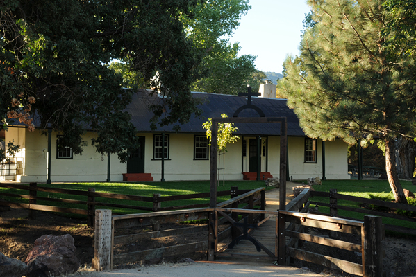
Main Building – Desert Studies Center

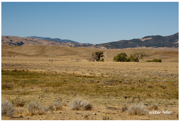
Zzyzx, pronounced “zy-zicks,” is a unique and intriguing place in the Mojave Desert of Southern California, USA. Specifically, it is home to the Desert Studies Center, operated by the California State University (CSU) system. The center serves as a field station for research and education focused on the desert ecosystem.

Here are some key points about Zzyzx and the Desert Studies Center:

  1. Location: Zzyzx is approximately 100 miles northeast of Los Angeles, near Baker, California. The Desert Studies Center is part of the larger California State University system and is used for academic and research purposes.
  2. History: The name “Zzyzx” was given to the area by Curtis Howe Springer, a self-proclaimed medical doctor and radio evangelist who established the Zzyzx Mineral Springs and Health Spa in the 1940s. The name was created to be the last word in English, and Springer intended to use it for marketing purposes. However, in 1974, the Bureau of Land Management (BLM) reclaimed the land, and it became the site for the Desert Studies Center.
  3. Desert Studies Center: The Desert Studies Center is a research and educational facility jointly operated by the California State University system. It provides a base for researchers, students, and educators interested in studying the unique ecology and geology of the Mojave Desert. The center offers facilities for field courses, workshops, and research projects related to desert studies.
  4. Facilities: The Desert Studies Center has dormitories, classrooms, laboratories, and other amenities to support researchers and students. It serves as a hub for scientific exploration and learning about the challenges and adaptations of life in desert environments.
  5. Research: Researchers at the Desert Studies Center focus on various topics, including desert ecology, geology, climate, and biodiversity. The unique characteristics of the Mojave Desert make it an ideal location for studying desert ecosystems and understanding how plants, animals, and microorganisms have adapted to this arid environment.

Visitors to the Desert Studies Center can explore the surrounding Mojave Desert, learn about its flora and fauna, and gain insights into the challenges and opportunities presented by desert ecosystems. It’s a valuable resource for those interested in environmental science, ecology, and desert studies.
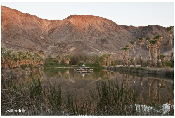
Lake Tuendae

Tejon Ranch

/beale-adobe/

The Tejon Ranch, located in California, has a rich and varied history that spans centuries.

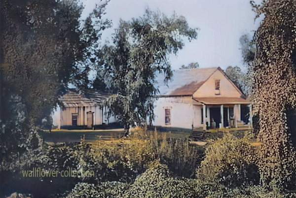
Tejon Ranch Headquarters

Here is an overview of its history:

  1. Native American Presence: The area around Tejon Ranch was originally inhabited by Native American communities, including the Kitanemuk people. These indigenous groups had a deep connection with the land, relying on its resources for their sustenance.
  2. Spanish Era: With the arrival of Spanish explorers and missionaries in the 18th century, the Tejon Ranch area became part of the vast landholdings of the Spanish missions and the California missions system. The land was used for cattle ranching and agriculture to support the missions.
  3. Mexican Land Grants: Following Mexico’s independence from Spain in 1821, the Mexican government began granting large tracts of land, including the Tejon Ranch, to private individuals. The Rancho El Tejon was granted to José Antonio Aguirre in 1843.
  4. Gold Rush and Transition: The California Gold Rush of 1848-1855 brought significant changes to the region. The influx of people seeking gold and the economic and political shifts associated with the U.S.-Mexican War led to the end of Mexican land grants. 1852, the U.S. government affirmed the land grant, and Benjamin and James Roberts acquired the Rancho El Tejon.
  5. Ranching and Agriculture: The Tejon Ranch became a center for ranching and agriculture. Cattle ranching, farming, and other activities flourished on the vast expanse of land. The ranch was crucial in supplying beef and other products to growing communities in Southern California.
  6. Treaty of Fort Tejon: In 1854, the U.S. government negotiated the Treaty of Fort Tejon with various Native American tribes, including the Kitanemuk. However, the treaty was not fully implemented, leading to conflicts and struggles for the indigenous people.
  7. Railroad Development: The Southern Pacific Railroad played a significant role in developing the Tejon Ranch. In the late 19th century, the railroad bypassed the Tehachapi Mountains, where the ranch is located, favoring a route through the nearby Tehachapi Pass. This decision affected the economic growth of the Tejon Ranch region.
  8. 20th Century and Beyond: The Tejon Ranch underwent various ownership and land use changes. In the 20th century, it evolved into a diversified operation involving agriculture, ranching, and commercial activities. The Tejon Ranch Company, established in the early 1900s, was key in managing and developing the property.

Today, the Tejon Ranch remains one of the largest privately-owned ranches in California, known for its conservation efforts, including partnerships with environmental organizations to preserve significant portions of the land as open space. The ranch’s history reflects the broader historical and cultural shifts in California, from indigenous habitation to Spanish colonization, Mexican land grants, and the economic transformations of the 19th and 20th centuries.

E.F. Beale and the Tejon Ranch

Edward Fitzgerald Beale, often referred to as E.F. Beale, played a significant role in the history of the Tejon Ranch.

Tejon Ranch – La Liebre Rancho

Here’s an overview of his connection to the ranch:

  1. Military Career: E.F. Beale was born in 1822 and had a distinguished military career. He served as a lieutenant in the U.S. Navy and later became Superintendent of Indian Affairs in California and Nevada.
  2. Surveyor and Explorer: In the 1850s, Beale was appointed by the U.S. government to survey and explore a wagon road along the 35th parallel from Fort Defiance in Arizona to the Colorado River. This expedition, known as the Beale Wagon Road, aimed to improve transportation and communication between the East and the newly acquired territories in the West.
  3. Tejon Ranch and the Wagon Road: The Beale Wagon Road passed through the Tejon Ranch, linking Fort Tejon to the Colorado River. Beale recognized the strategic importance of the Tejon Pass for transportation routes and recommended it as a route for the railroad.
  4. Land Acquisition: In 1861, Beale purchased the Rancho El Tejon, which included the Tejon Ranch. He acquired the property from the prominent rancher General Edward Beale Tracy. E.F. Beale engaged in various agricultural and ranching activities on the land.
  5. Conservation and Agriculture: Beale was not only interested in ranching but also in conservation. He introduced various agricultural improvements to the ranch, including cultivating wheat and vineyards. Beale also advocated for land conservation and recognized the need to protect natural resources.
  6. Tejon Ranch Company: In the early 20th century, the Tejon Ranch changed ownership and management. The Tejon Ranch Company was established in 1936, and E.F. Beale’s descendants were involved in the company’s operations.
  7. Legacy: E.F. Beale’s legacy is intertwined with the history of the Tejon Ranch. His contributions to the development of transportation routes, his role in the acquisition of the ranch, and his efforts in both ranching and conservation have left a lasting impact on the region.
Tejon Ranch winter quarters

Today, the Tejon Ranch remains a significant property in California, known for its historical, cultural, and environmental importance. The Tejon Ranch Company continues to manage the property, balancing agricultural activities with conservation initiatives and partnerships to preserve large portions of the land as open space.

Desert Rockhounding

Desert rockhounding is a popular recreational activity that involves searching for, collecting, and identifying rocks, minerals, gemstones, and fossils in arid regions. Deserts often have unique geological formations and a diverse range of minerals, making them interesting and rewarding for rockhounding enthusiasts. Here are some tips for desert rockhounding:

  1. Research the Area: Before heading out, research the desert area you plan to explore. Learn about the geology, rock formations, and the types of minerals or gemstones commonly found in that region. Geological maps and online resources can be valuable tools.
  2. Check Regulations: Be aware of any regulations or restrictions in the area you plan to visit. Some areas may have rules about collecting rocks, and respecting these regulations is important to preserve the environment.
  3. Safety First: Deserts can be challenging environments with extreme temperatures. Wear appropriate clothing, including a hat, sunscreen, and sturdy footwear. Carry plenty of water and be mindful of your surroundings to ensure a safe and enjoyable rockhounding experience.
  4. Use the Right Tools: Bring the necessary rock-hounding tools, such as rock hammers, chisels, safety glasses, gloves, and a backpack to carry your finds. A field guide to rocks and minerals can help you identify your discoveries.
  5. Explore Washes and Dry Creek Beds: Water action in desert washes can concentrate rocks and minerals, making these areas fruitful for rockhounding. Explore dry creek beds, washes, and areas where water has flowed in the past.
  6. Look for Indicator Minerals: Certain minerals may indicate the presence of valuable gemstones or other interesting specimens. Learn to recognize indicator minerals and follow their trail to potential collecting sites.
  7. Be Respectful: Leave no trace and practice ethical rockhounding. Avoid damaging plants, disturb the environment as little as possible, and fill in any holes you may dig. Remember that some areas may be protected, and it’s important to respect these conservation efforts.
  8. Join Rockhounding Clubs: Consider joining local rockhounding clubs or groups. These organizations often have experienced members who can share knowledge about the best collecting sites and provide guidance on responsible rockhounding practices.
  9. Time Your Visit: The best time for desert rockhounding is during the cooler months, as summer temperatures can be extremely high. Early morning and late afternoon are generally more comfortable and offer better lighting for observing and collecting.
  10. Learn to Identify Rocks: Familiarize yourself with the characteristics of rocks and minerals commonly found in the desert. Understanding the properties, colors, and formations of different specimens will enhance your rockhounding experience.

Always be aware of your impact on the environment and prioritize conservation while enjoying the excitement of discovering rocks and minerals in the desert.

Rockhound

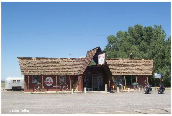
Bagdad Cafe

/route-66/

Sidewinder Cafe - Bagdad Cafe, Newberry Springs, Route 66
Bagdad Cafe (formerly Sidewinder Cafe) Newberry Springs, Ca.


“Bagdad Cafe” refers to a 1987 film and a subsequent television series. The film, originally titled “Out of Rosenheim,” was directed by Percy Adlon. The story revolves around a German tourist named Jasmin Münchgstettner, played by Marianne Sägebrecht, who finds herself stranded in the Mojave Desert. She ends up at a run-down motel and café called the Bagdad Cafe, where she forms an unlikely friendship with the cafe’s owner, played by CCH Pounder.

The film explores themes of isolation, friendship, and cultural differences, and it gained acclaim for its unique characters and quirky charm. The original German title, “Out of Rosenheim,” refers to the character’s departure from her mundane life in Rosenheim, Germany.

The film’s success led to creating a television series titled “Bagdad Cafe,” which aired from 1990 to 1991. The TV series continued the film’s story, featuring some original characters and expanding on the adventures at the Bagdad Cafe.

The film and the TV series have garnered a cult following for their offbeat and heartwarming storytelling. The Bagdad Cafe, located in Newberry Springs, California, along Historic Route 66, has become a popular tourist attraction.

/newberry-springs-ca/

The Captivity of Olive Oatman

A Harrowing Tale of Survival and Resilience

Introduction

The story of Olive Oatman, a young girl who endured unimaginable hardships during her captivity among Native American tribes in the mid-19th century, has become an emblem of resilience and survival. This blog post delves into the gripping account of Olive Oatman’s captivity, shedding light on the challenges she faced and the strength she exhibited throughout her ordeal.

The Oatman Family’s Journey

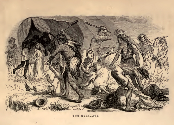
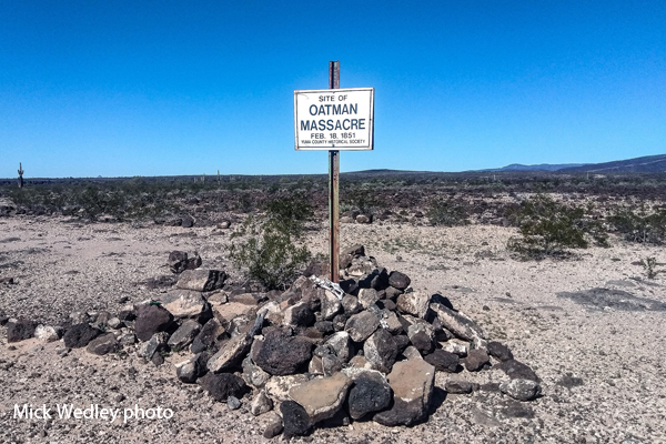
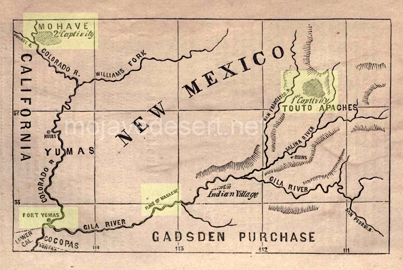
In 1850, the Oatman family embarked on a treacherous journey from Illinois to California, seeking a better life in the West. Unfortunately, their dreams were shattered when they encountered a Native American tribe, the Yavapai, along the Gila River in present-day Arizona. The tribe, driven by desperation and a history of violence against settlers, attacked the Oatman family. All but Olive and Mary Ann were brutally killed. Brother Lorenzo also survived but was left for dead listening to his mothers cries as she held her infant in the rocks where they were thrown.

Oatman family massacre site – Mick Wedley photo

Captivity Among the Yavapai

The Yavapai tribe took Olive, and her younger sister, Mary Ann, captive, subjecting them to constant fear and uncertainty. A year after their capture, they were traded to the Mohave tribe.

Life Among the Mohave

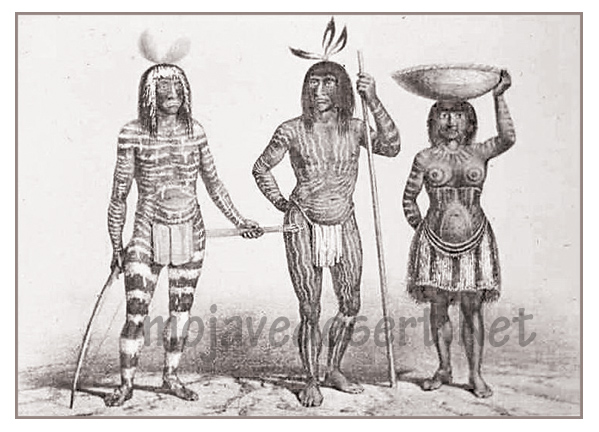
Mohave Indians

Under the care of the Mohave tribe, Olive and Mary Ann were gradually integrated into their new community. The Mohave people treated them with relative kindness, adopting them as members of their tribe and providing them with food and shelter. Olive even received facial tattoos, which were traditional among the Mohave, symbolizing her assimilation into their culture.

Rescue and Reintegration

After five years of captivity, Olive’s story took a dramatic turn when her younger sister, Mary Ann, tragically passed away due to starvation. Determined to return to her white heritage, Olive caught the attention of American authorities, urged by Lorenzo, and eventually negotiated her release. Upon her return to white society, Olive faced challenges in readjusting to her former life. Her facial tattoos, a constant reminder of her captivity, presented a unique hurdle in her reintegration.

Legacy and Impact

The story of Olive Oatman’s captivity quickly captivated the public’s imagination, symbolizing resilience and endurance in the face of adversity. Her tale was widely publicized, and she became somewhat of a celebrity during her lifetime. Olive’s memoir, “Captivity of the Oatman Girls,” published in 1857, further immortalized her experiences and shed light on the often misunderstood dynamics between Native American tribes and settlers during that era.

Conclusion

The captivity of Olive Oatman stands as a testament to the indomitable spirit of human will. Her story serves as a reminder of the strength and resilience of the human spirit in the face of unimaginable hardship. Olive Oatman’s legacy endures, inspiring generations to overcome adversity and find courage even in the darkest of times.

(c)Walter Feller

The Captivity of the Oatman Girls

Olive Oatman

Mojave River: A Lifeline in the Desert

Introduction:

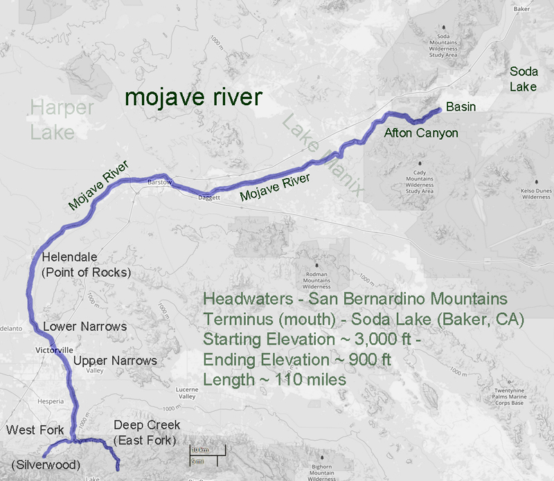
The Mojave River, a hidden gem in the arid landscapes of California, serves as a vital lifeline in the Mojave Desert. This remarkable river spans approximately 110 miles and offers a diverse ecosystem, historical significance, and recreational opportunities for nature enthusiasts and history buffs.

Geography and Formation:

The Mojave River originates in the San Bernardino Mountains and meanders through the Mojave Desert, eventually dissipating into Soda Lake. Its path encompasses various landscapes, including rugged canyons, barren deserts, and lush riparian habitats. The river’s formation can be traced back thousands of years ago when geological processes and the ever-changing climate of the region shaped its course.

Ecological Importance:

Despite the harsh Mojave Desert conditions, the Mojave River sustains a surprising array of flora and fauna. The river’s riparian zones provide an ideal habitat for a variety of plant species, such as willows, cottonwoods, and mesquite trees. These lush areas attract diverse wildlife, including birds, reptiles, and mammals, seeking refuge in this desert oasis.

Historical Significance:

The Mojave River holds a significant place in the history of California. Native American tribes, such as the Mojave, Serrano, and Chemehuevi, once relied on the river’s resources for sustenance and survival. European explorers, including Spanish missionaries and fur trappers, ventured along its banks, leaving behind a legacy of cultural exchange and exploration.

Moreover, during the mid-1800s, the Mojave River played a crucial role in the development of the Old Spanish Trail and the Mojave Road. These historic trade routes linked the Spanish colonies of California with the eastern United States, facilitating trade and migration.

Recreational Opportunities:

For outdoor enthusiasts, the Mojave River offers a plethora of recreational activities. Hiking trails, such as the Mojave Riverwalk Trail, provide opportunities for exploration, allowing visitors to immerse themselves in desert scenery. Camping facilities and picnic areas along the river’s banks provide the most idyllic setting for a peaceful getaway amidst nature’s tranquility.

Conservation Efforts:

Recognizing the importance of preserving this vibrant ecosystem, numerous conservation organizations and government agencies have worked to protect and restore the Mojave River. These initiatives focus on sustaining river water quality and preserving riparian habitats.

Conclusion:

The Mojave River stands as a testament to the resilience of nature in the face of adversity. Its meandering path through the Mojave Desert provides a lifeline for both wildlife and humans, offering a sanctuary amidst the arid landscapes. Whether you are a nature lover, history enthusiast, or adventure seeker, the Mojave River is a destination that promises a unique and memorable experience. So, embark on a journey to this desert oasis, and let the Mojave River captivate you with its beauty and allure.

Indifference of the Desert: Gateway to Eternity

The desert, a vast expanse of arid land, holds an enigmatic allure that has captivated explorers, writers, and artists for centuries. In its barrenness lies a certain indifference, an apathy that transcends the human realm. It is a world of endless silence, where life struggles to survive, and time appears to stand still. This place, looking into the indifferent nature of the desert, exploring its striking beauty, unforgiving climate, and ability to evoke a sense of insignificance in the face of its vastness.

The desert’s indifference is paradoxically intertwined with its mesmerizing beauty. Stretching as far as the eye can see, the landscape is dominated by sand dunes, rocky outcrops, and expansive plains. The desert’s neutral color palette, comprising earthy tones of beige, ochre, and rust, creates a harmonious symphony of hues. Its vastness and emptiness instill a sense of awe as if gazing upon an infinite canvas that has been left untouched by human hands.

The desert’s indifference is most apparent in its extreme climate. The desert’s temperatures fluctuate dramatically from scorching heat during the day to bone-chilling cold at night. The barrenness of the landscape exacerbates these conditions, as there are no obstacles to provide shade or shelter. Survival in such an environment requires adaptation and resilience, as even the hardiest of creatures struggle to endure the harshness of the desert’s indifference.

In the desert, time seems to lose its relevance. The shifting sands, sculpted by the wind, erase any trace of human presence, leaving behind a blank canvas for nature to paint anew. The desert’s indifference to the passage of time can be both humbling and disorienting. It serves as a reminder of the transience of human existence, as the footprints we leave behind are quickly swallowed by the relentless sands, making us feel insignificant in the face of eternity.

While the desert’s indifference may seem daunting, it offers valuable lessons for those who are willing to listen. It teaches us to embrace solitude and find solace in our own company. It encourages us to adapt and persevere in the face of adversity. It reminds us of the impermanence of life and the importance of cherishing the present moment. The desert’s indifference serves as a gentle yet profound reminder of our place in the grand tapestry of the universe.

The indifference of the desert is a captivating paradox. Its silent beauty, harsh climate, and timeless sands evoke a sense of insignificance in the face of its vastness. Yet, within its indifference lies wisdom and resilience. The desert beckons us to embrace solitude, adapt to change, and appreciate the fleeting nature of existence. Let us heed its call and find solace in the indifference of the desert, for within its silence lies a profound understanding of the human condition.

(c)Walter Feller

Battle at Chimney Rock

History of San Bernardino and Riverside counties
Brown, John & Boyd, James – 1922

 Typical of the troubles of the times is the following article from a local newspaper of February 1867: “For several years past, our citizens have been greatly annoyed by roving bands of Indians who come into the valley and steal all the horses and cattle they find unguarded. Nor do they hesitate to attack stockmen and travelers if an opportunity offers. Already Messrs. Parish, Bemus and Whiteside, and a dozen others have fallen victim to their bloodthirstiness within the past four years. Growing bolder by impunity, on the 29th of January, they attacked the sawmill of Mr. James upon the mountain, a few miles east of this place, having previously robbed the house of Mr. Cain, carrying off five horses and burned down the house. The party at the mill, consisting of Messrs. Armstrong, Richardson, Cain, and Talmadge, sallied out to meet them. A brisk fight followed when the party, finding that most of the Indians had guns and fearful of being overpowered, retreated to the mill. The next morning the party, having been reinforced, went out and was attacked again, the fight lasting for more than an hour. Two of the white men were wounded, two Indians were killed, and three wounded. A party was made up to pursue these Indians, and after following them, found the Indians encamped in the desert at Rabbit Springs. The company made an attack, the men having to climb up the steep mountains and over the rocks on all fours, and the skirmishing lasted until dark. The skirmishing lasted for two days longer when the whites were compelled to withdraw because supplies were exhausted. Four Indians were killed and two of the white party wounded.” The Mojave region came under the protection of Camp Cady, which was established as a regular military post in 1868 on the road between Wilmington and Northern Arizona territory, and about 100 troops under Colonel Ayers remained here until about 1870.

Alfalfa

This article was written circa 1904

The cultivation of alfalfa has become an important industry in this
state and throughout the West. As San Bernardino County can claim the
first successful culture of this plant in the United States, a brief outline of
its history may not be out of place.

Lucerne Valley, Ca.

Alfalfa is the oldest grass known, having been introduced into Greece
from Media, 500 years before Christ. The Romans, finding its qualities good, cultivated it extensively and carried it into France when Caesar reduced Gaul. It has always been extensively cultivated in Europe under the name of lucerne, supposed to be derived from the province of Lucerne in Switzerland. The name alfalfa was given to the plant in Chili, where it grows spontaneously in the Andes as well as on the pampas of that country and of the Argentine Republic.

Oro Grande, Ca.

It was introduced into the United States as early as 1835—and probably
earlier—and attempts at cultivation in New York and other Eastern states
were unsuccessful.

In the United States Agricultural Report for 1872, Mr. N. Wyckoff, of
Yolo, Napa County, Cal, reports: “In the winter of 1854. I sowed four acres
with alfalfa, or lucerne, as it was then called, seed brought from Chili. As
far as I know, it was a part of the first parcel of seed brought into this
country. My sowing proved so foul with weeds that I plowed it up and
did not re-sow until 1864.” The United States Agricultural Report of
1878, a considerable production of alfalfa is reported from some of the
northern counties of the state.

In the winter of 1852-3, a party of Mormons arrived in San Bernardino from Australia. At least one of the party, Mr. John Metcalf, brought with him some alfalfa seed. This was sown on his place, now the Metcalf place on Mount Vernon Avenue, near First street. It was irrigated from Lytle Creek and did well, and the plant was soon cultivated by others. The seed was at first sold for $1.00 per pound and was distributed from San Bernardino to other points in Southern California. The early supply of seeds for Los Angeles was obtained from San Bernardino and the seed was taken from here to Salt Lake thus the alfalfa industry, one of the most important in Utah, was started. The alfalfa crop is now one of the most important of the county and San Bernardino County had, in 1900, more than six thousand acres seeded to this plant.

INGERSOLL’S CENTURY ANNALS OF
San Bernardino County
1769 to 1904 (201)

Wrong-Way River

by walter feller

Mojave River

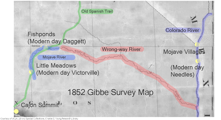
In 1852 a survey was made of the southwestern edge of the Mojave Desert. The Old Spanish Trail # had become a wagon road bringing thousands of pioneers to the west and developed as a supply route between Los Angeles and Salt Lake City. The survey was as accurate as any at that time and followed the trail from near the top of the Cajon Pass to a point where the trail leaves the Mojave River near Fishponds. The trail to Salt Lake continues north as we know it, but the river flowing east on this map bears southeast and empties into the Colorado River. At the time it was thought the Mojave (spelled Mohahve on the map) River followed this course. It did not. There was no Mojave Road in 1852 and not many Americans had traversed that portion of the desert. As we now know the Mojave River cuts through Afton Canyon and then disappears into the sink of the Mojave before it reaches Soda Lake.

The Williamson survey the next year in 1853 begins to correct the true ancient course of the river as it would have found its way to converge with the Amargosa River and empty into Death Valley’s Lake Manly via Soda Lake, Silver Lake, Silurian Lake, and Salt Springs.

-End –