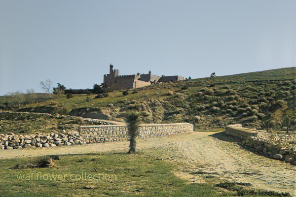
“Shea Desert Castle Sold,” Los Angeles Times, 25 Mar 1935 (colorized)
Richard Peter Shea built Shea’s Castle in 1924, also known as Sky Castle or Castle Ranch.
1929’s stock market crash bankrupted Shea. Shea’s wife died, the bank took over the castle, and Shea committed suicide.
Over the years, the property has changed hands and been used as a filming location.
Trigger, Roy Rogers’ horse, was trained on the property.
It is now a private residence.
The massive granite structure, built by R. P. Shea, was sold to three Beverly Hills women in 1935. The “castle” boasts many unique design elements that remain untouched after the purchase. This photograph appears with the article, “Shea Desert Castle Sold,” Los Angeles Times, 25 Mar 1935: 19.CAPTIONText from negative sleeve: Shae’s [sic] Castle nitrates
Handwritten on negative: Shae’s [sic] Castle 3-16-35 Text from newspaper caption: “Dream Home” in Mojave Desert Passes Into New Hands; A massive granite structure in the Mojave Desert, built ten years ago as a “dream home” of R. P. Shea, yesterday, passed into the hands of new owners. So incongruous is its setting that many believe they are beholding a mirage when they see the $175,000 castle.
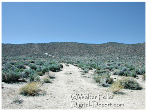
Skidoo came to life because of fog. When Harry Ramsey and a man called One-eye Thompson lost their way on a road leading to the new boom camp of Harrisburg, they stopped to rest near a log lying against an outcropping of rock. When the fog lifted, the rock turned out to be gold. This was back in 1905. In deciding upon a name for the town that sprung up, a numerologist associated a popular expression of the day, 23-Skidoo, with the fact that a Rhyolite man named Bob Montgomery had successfully piped water from Telescope Peak 23 miles away and suggested the name Skidoo. So it became.
Downtown Skidoo. Death Valley National Park
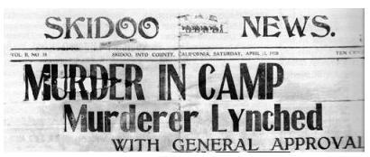
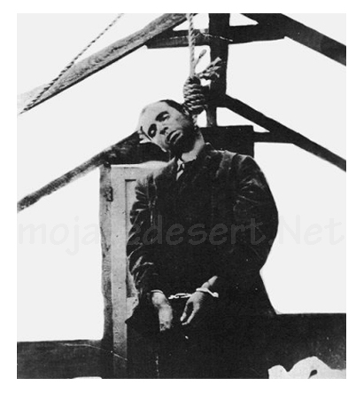
Old-timers say the camp produced over a million dollars worth of gold ore between its discovery and its demise some 20 years later. Skidoo’s chief claim to fame, however, was not its riches. Rather, it was an infamous lynching of a scoundrel named Joe Simpson in 1908.
On a tour to the ghost town of Skidoo in 1962, we were privileged to be accompanied by an 87-year-old gentleman named George Cook. The interesting thing about Mr. Cook was that it was he who pulled on the rope at the lynching. His participation had only recently been divulged to a few intimate friends—after all others involved had passed on to their rewards, or whatever.
Joe “Hooch” Simpson
“Joe Simpson,” Mr. Cook told us, ‘was a would-be villain who had killed a man at Keeler after shooting-up Jack Gun’s Saloon in Independence the preceding year. He’d somehow gotten off and drifted to Skidoo where he became a partner with Fred Oakes in the Gold Seal Saloon. Across the street was Jim Arnold’s Skidoo Trading Company.
“Arnold was a friendly, well-liked man and had always been on good terms with Simpson, but Simpson became drunk and abusive one April morning and decided to hold up a bank situated in part of Arnold’s Skidoo Trading Company. Apprehended, his gun was taken away and hidden by the deputy sheriff, but a little later Simpson found his weapon and returned to the store to shoot Jim Arnold. He then turned on two other men who had come to the rescue, but his aim was poor and both escaped. Eventually, Simpson was overpowered and placed under guard in the deputy sheriff’s cabin. Unfortunately,” Mr. Cook lamented, “the popular Jim Arnold died that night.”
Skidoo went wild with indignation. After Arnold’s funeral, which the entire camp attended, a group went to the improvised jail, led the prisoner out at the end of a rope, and hanged him to the nearest telephone pole. When Sheriff Nailor from Independence arrived, after a hazardous trip over rough roads via Tonopah and Rhyolite, he made the now famous statement, “It’s the best thing that ever happened to Inyo County; it saved us $25,000!”
But this wasn’t the end. Several spectators had forgotten their cameras and wanted pictures of the hanging. So, Joe Simpson’s body was obligingly strung up again, this time from the ridgepole of the tent where he was “laid out.” News of this gruesome encore spread and the lynching won everlasting fame. In his private narrative of the event, George Cook added a factor never before related: “Joe was dead before we got the rope around his neck; he died of a heart attack (from fright) and was already gone when dragged to the telephone pole scaffold.”
It was also he, George Cook confessed, who assisted Dr. MacDonald in removing the head from Simpson’s corpse. The doctor, it seems, had once performed an operation on Simpson s nose and wanted to make a further medical study of the case. Going at night, they performed the severance at the lonely prospect hole where Simpson’s body had been tossed. (No one in Skidoo would give him a decent burial, so great was the indignation at his senseless crime). The skull was exhibited for a period in a showcase at Wildrose, but later disappeared.
The remainder of the skeleton resisted oblivion, however. Years later when George Cook returned to Skidoo to work in the mill, an agitated prospector appeared one day to report a headless skeleton of a man who’d evidently been murdered. Because Cook was the only old-timer around at the time, he was consulted. Indeed a crime had been committed sometime, he agreed, but of the details, he had conveniently forgotten.
Last year George Cook passed away. Small in stature, religious, mild-tempered, and given to writing sentimental verse, he was the antithesis of our Western idea of a vigilante. The role forced upon him by his acute anger over the murder of a friend bothered this good man to the end of his days. His belief that Simpson did not expire at his hand appeared to be a real comfort. And, perhaps he was right. We cannot disagree, for George Cook was there.
Much interesting history is connected with the now-defunct Skidoo. Following its early boom, the town was deserted for a period, then, under new management, the mine and mill reopened during the 1930s and a period of production occurred. The old wild days never returned, however, and its fame as a mining camp still rests upon the lynching incident —to which we add, “Joe Simpson did not die because of a rope and a telephone pole. He died of a heart attack!”
by Myrtle Nyles – November 1964 – Desert Magazine
Editor’s Note: This is but one version of this story, and it is worth saying that it has generated many other versions and stories through its telling.
In January 1906 two wandering prospectors, John Ramsey and John (One-Eye) Thompson were headed towards the new gold strike at Harrisburg. Along the way a blinding fog came in and the two camped near Emigrant Spring for fear of getting lost. …More …
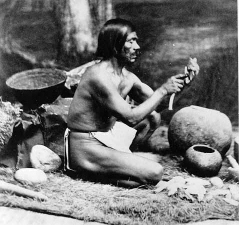
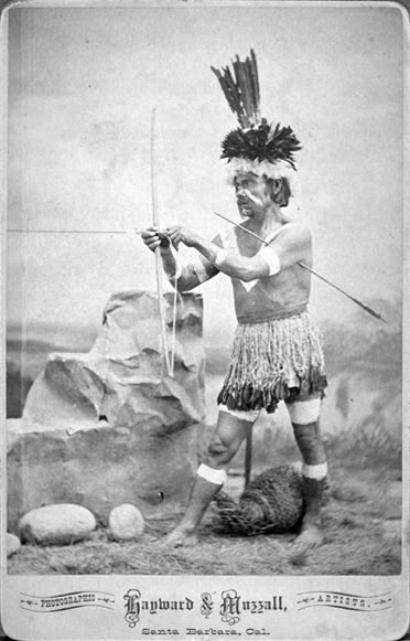
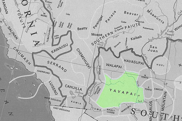
The Chumash are a Native American people who historically inhabited the coastal and inland regions of California, particularly the Central and Southern California coastal areas. Their traditional territory includes areas from the Santa Barbara Channel to Malibu. The Chumash are considered part of the Hokan language family.
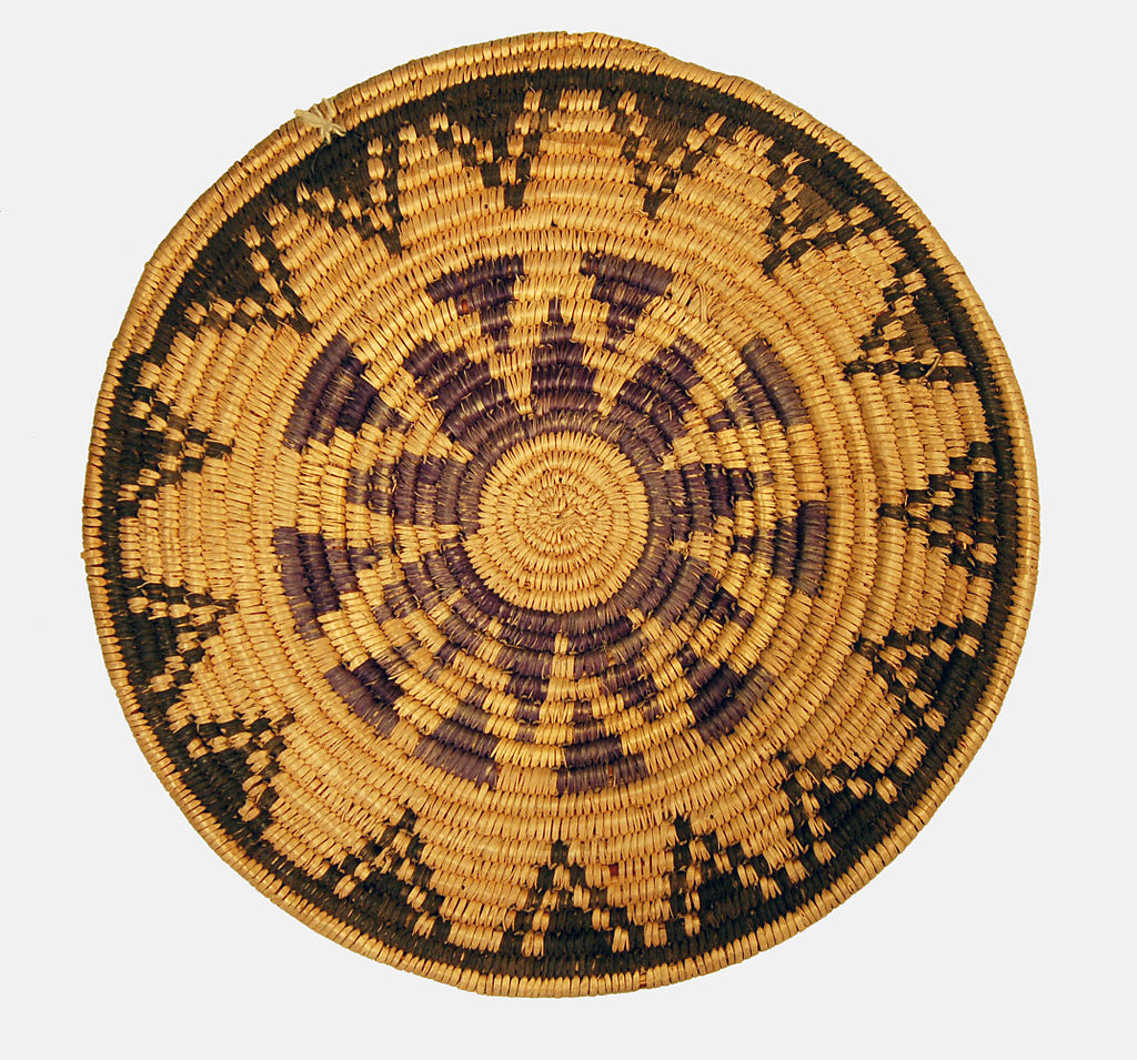
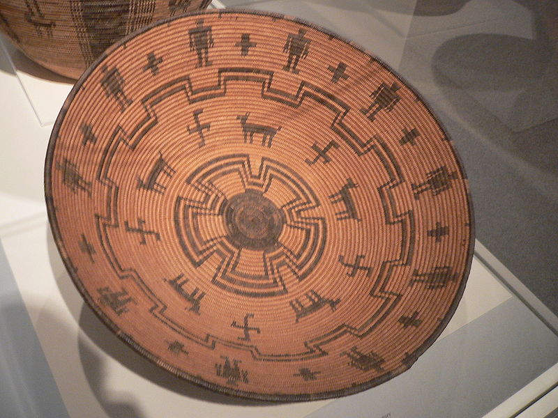
The Chumash people are known for their complex social organization, advanced maritime technology, and well-developed basketry and rock art. They were skilled fishermen, hunters, and gatherers, relying on the rich marine resources of the Pacific Ocean as well as the diverse plant and animal life in their environment.
The Chumash were organized into chiefdoms, each with its leader, and they lived in villages with plank-built houses. Their society had a sophisticated economic and political structure and traded with neighboring tribes.
With the arrival of Spanish explorers in the 18th century, the Chumash were profoundly affected by European colonization. Spanish missions were established in Chumash territory, leading to changes in their way of life, the introduction of new diseases, and the disruption of their social structures.
Today, Chumash people continue to maintain and revitalize their cultural traditions. Ongoing efforts are to preserve Chumash languages, arts, and traditional knowledge. Some Chumash individuals and communities are also involved in cultural and educational initiatives, including managing tribal museums and interpretive centers that showcase Chumash history and heritage.
The Chumash are recognized as a sovereign tribal nation, and contemporary issues include discussions about tribal governance, land rights, and the broader acknowledgment of indigenous rights in the United States.
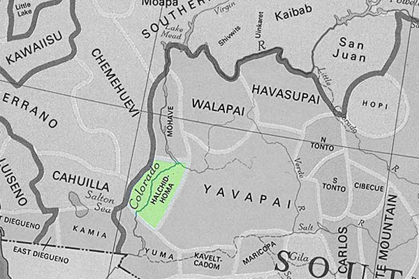
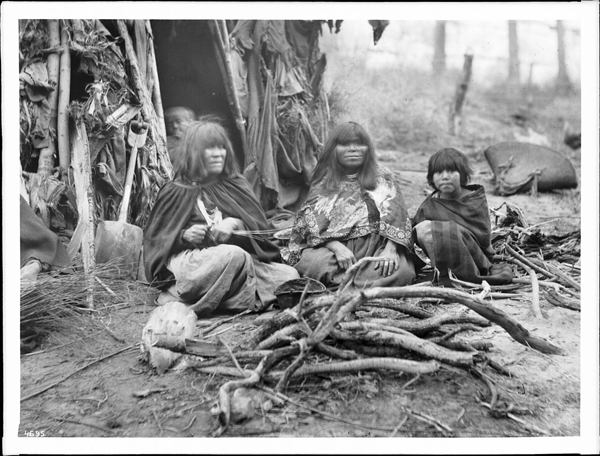
The Halchidhoma (also spelled Halchidoma or Haltchidhoma) was a Native American tribe historically inhabiting the southwestern United States. They were part of the Yuman language-speaking people and lived in the lower Colorado River region, particularly in what is now Arizona and California. The Halchidhoma were closely related to other Yuman-speaking groups, such as the Mojave, Quechan, and Cocopah.
The Halchidhoma people were known for adapting to the desert environment and were skilled at fishing, hunting, and gathering resources in the arid landscape. They utilized the Colorado River for sustenance, catching fish, and utilizing plants for food, medicine, and other purposes.
However, the Halchidhoma tribe faced significant challenges with the arrival of European colonizers and the subsequent westward expansion of the United States. The disruption caused by the influx of settlers, diseases, and conflicts with other Native American groups and European colonists contributed to the decline of the Halchidhoma population.
Over time, the Halchidhoma people faced displacement, and their distinct tribal identity gradually faded. Today, the Halchidhoma are considered one of the many Native American groups whose historical presence has diminished, and their cultural heritage is often studied through archaeological and historical records.
It’s important to note that the history of Native American tribes is complex, and various factors, including interactions with European settlers, government policies, and environmental changes, have shaped their experiences.
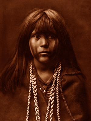
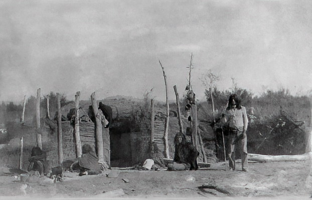
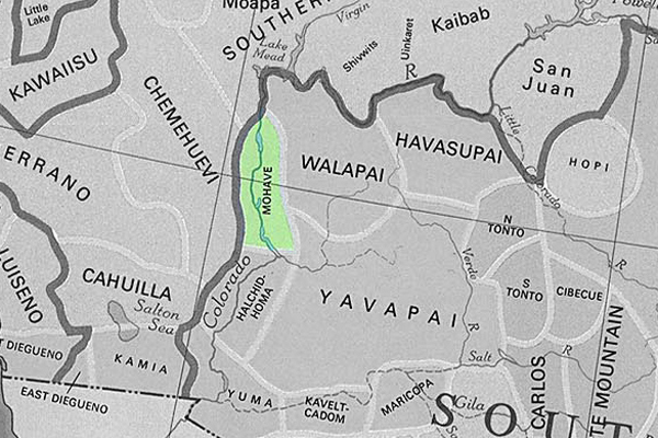
The Mojave are Native American people who traditionally inhabited the Mojave Desert, which spans parts of California, Arizona, Nevada, and Utah in the United States. The Mojave people are part of the larger Yuman language family.
The Mojave are known for their adaptation to the harsh desert environment and their traditional lifestyle as hunter-gatherers. They relied on the diverse resources of the desert, including native plants, seeds, and the hunting of small game. The Colorado River, which flows through their territory, played a significant role in their lives.
Historically, the Mojave people lived in small family groups and had a strong sense of community. They built dome-shaped houses known as “kish,” their social organization included tribal leaders and spiritual figures.
With European settlers’ arrival and the United States’s expansion in the 19th century, the Mojave, like many other Native American groups, faced significant challenges. European diseases, conflicts over land, and changes in their traditional way of life profoundly affected their population and culture.
Today, the Mojave people continue to maintain their cultural traditions and have a presence on the Fort Mojave Indian Reservation, which spans parts of California, Arizona, and Nevada. Efforts are underway to preserve the Mojave language, arts, and traditional knowledge. Additionally, like other Native American groups, the Mojave is engaged in discussions about tribal sovereignty, land rights, and broader issues related to recognizing indigenous rights.
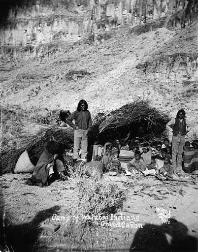
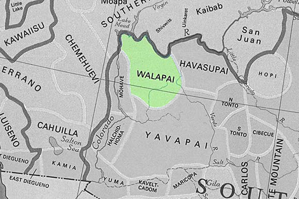
The Hualapai, also spelled Walapai, are a Native American people who traditionally lived in the western part of the United States, primarily in the Hualapai Indian Reservation in northwestern Arizona. They are part of the larger Yuman language family.
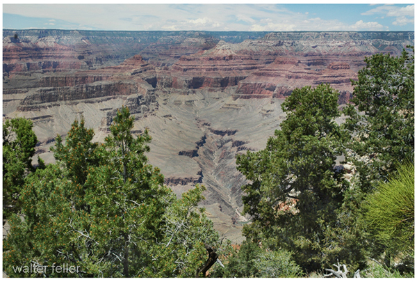
The Hualapai people are known for their strong connection to the Grand Canyon, as a significant portion of their reservation includes parts of the Grand Canyon and the Colorado River. The term “Hualapai” translates to “People of the Tall Pines” in their language, reflecting the importance of the pine forests in their traditional territory.
Historically, the Hualapai were hunter-gatherers, relying on the resources of their diverse environment, including the Grand Canyon, plateaus, and mountainous regions. They hunted game, gathered plants, and engaged in cultural practices that reflected their close relationship with the land.
With the arrival of European settlers and the expansion of the United States, the Hualapai faced challenges such as the loss of traditional lands, conflicts over resources, and changes in their way of life. In the late 19th century, the Hualapai Reservation was established, providing a designated area for the tribe.
Today, the Hualapai people continue to preserve their cultural heritage. The Hualapai Reservation is a popular destination for tourists interested in experiencing the Grand Canyon from the perspective of the Hualapai people. The Hualapai Tribe is also known for managing the Grand Canyon Skywalk, a glass bridge that extends over the Grand Canyon.
Efforts are ongoing to maintain and revitalize the Hualapai language, arts, and traditional knowledge. Like many other Native American groups, the Hualapai are actively engaged in issues related to tribal sovereignty, land rights, and the broader recognition of indigenous rights.
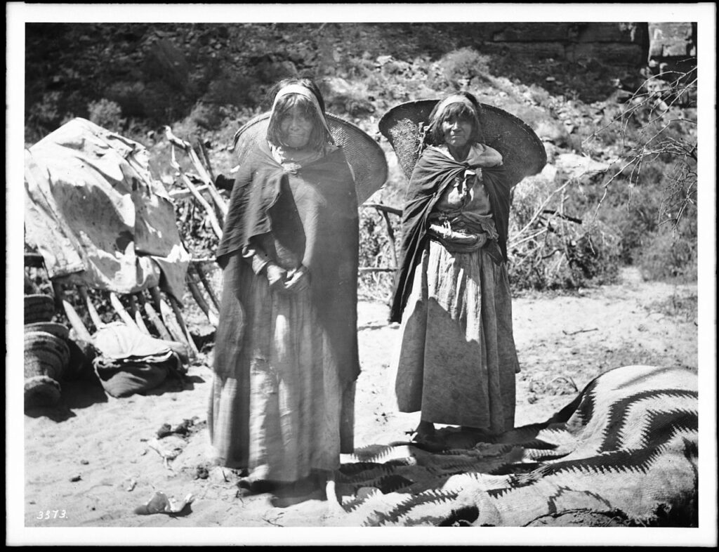
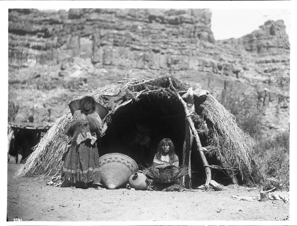
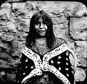
The Havasupai, or Havasu ‘Baaja, are a Native American people who have traditionally lived in the Grand Canyon region of Arizona, particularly in Havasu Canyon. “Havasupai” means “people of the blue-green water,” which reflects the turquoise color of the Havasu Creek that flows through their ancestral lands.
Havasupai’s history and culture include their deep connection to the Grand Canyon, reliance on the area’s natural resources, and their traditional practices as hunter-gatherers. Havasupai people historically hunted game, gathered plants, and engaged in trade with neighboring tribes.
In 1882, the U.S. government established the Havasupai Indian Reservation, which encompasses about 188,077 acres and includes the Havasu Canyon. The reservation is situated within the larger Grand Canyon National Park.
Some notable features of Havasupai land are the Havasu Falls, Mooney Falls, and other waterfalls along Havasu Creek. These natural wonders, known for their striking blue-green waters, attract visitors worldwide.
The Havasupai people maintain cultural traditions, including traditional ceremonies, crafts, and storytelling. The Havasupai language is also preserved within the community.
Tourism plays a significant role in the Havasupai economy, as visitors are allowed to experience the beauty of Havasu Canyon, including its waterfalls and hiking trails. However, the community also faces challenges in maintaining the delicate balance between tourism and preserving cultural and natural resources.
Like other Native American groups, the Havasupai are actively engaged in issues related to tribal sovereignty, land rights, and the broader recognition of indigenous rights.
The Cocopah, or Cocopah Tribe, are a Native American people who traditionally lived along the lower Colorado River in the southwestern United States and northern Mexico. Their homeland includes areas in Arizona and California, as well as the Baja California region of Mexico. The Cocopah are part of the larger Yuman language family.
Historically, the key aspects of Cocopah culture included fishing, hunting, and gathering in the desert and riverine environments. They were skilled in constructing traditional houses called “káak” or “mat káak” made from arrowweed and brush. The Cocopah people have a rich cultural heritage, including traditional songs, dances, and ceremonies.
With the arrival of European settlers, the Cocopah, like many other Native American groups, faced challenges such as changes in their way of life, conflicts, and the loss of traditional lands. The Cocopah Reservation, established in the United States, is located near Somerton in southwestern Arizona.
Today, the Cocopah Tribe is engaged in cultural preservation efforts, including revitalizing the Cocopah language, traditional arts, and ceremonies. The tribe is also involved in economic development initiatives, education, and healthcare programs to benefit its community members.
The Cocopah people maintain a connection to their ancestral lands and the Colorado River, an important aspect of their cultural identity. Issues related to tribal sovereignty, water rights, and the broader recognition of indigenous rights are significant considerations for the Cocopah Tribe.
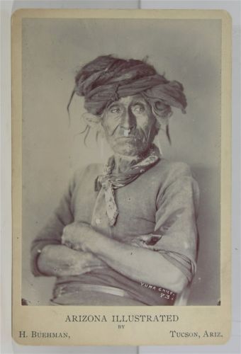
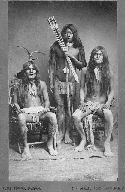
The Quechan also spelled Kwtsaan or Kwtsan, are a Native American people who traditionally inhabited the lower Colorado River Valley, including parts of present-day Arizona and California. The Quechan are part of the larger Yuman language family.
The Quechan people have a rich cultural heritage, including traditional ceremonies, dances, and crafts. They historically relied on the resources of the region, such as fish from the Colorado River, wild plants, and small game.
One of the well-known groups within the Quechan people is the Fort Yuma Quechan Tribe, which is based on the Fort Yuma Indian Reservation. The Fort Yuma Indian Reservation is near the present-day city of Yuma, Arizona, along the Colorado River. The Quechan people have a long history in the region, and their reservation is an important center for preserving and promoting their cultural traditions.
With the arrival of European settlers and the establishment of the United States, the Quechan, like many Native American groups, faced challenges such as the loss of traditional lands, conflicts, and changes in their way of life. However, they have persisted in maintaining their cultural identity and practices.
Today, the Quechan Tribe is actively involved in issues related to tribal sovereignty, land rights, and the broader recognition of indigenous rights. The Fort Yuma Quechan Tribe engages in various cultural and educational initiatives to preserve and revitalize their language, arts, and traditions, ensuring their heritage is passed on to future generations.
The Yavapai are a Native American people who traditionally inhabited Arizona’s central and western regions in the southwestern United States. Their name is derived from the Yavapai word “Enyaeva,” meaning “people of the sun.” The Yavapai are closely related to the Havasupai, Hualapai, and Apache peoples and share linguistic and cultural ties.
Historically, the Yavapai were semi-nomadic, engaging in hunting, gathering, and some agriculture. They hunted game, gathered plants and seeds, and cultivated crops in the riparian areas along rivers.
With European settlers’ arrival and the United States’ westward expansion, the Yavapai, like many other Native American groups, faced significant challenges. They experienced conflicts with European settlers and the loss of their traditional lands.
The Yavapai people were forcibly removed from their ancestral lands and faced forced marches and resettlements in the late 19th century. This period was marked by hardship and suffering, and many Yavapai people were relocated to the San Carlos Apache Reservation.
Today, the Yavapai-Apache Nation is a federally recognized tribe that represents the descendants of the Yavapai and Apache people. The Yavapai-Apache Nation has reservations near Camp Verde and Clarkdale in Arizona. The tribe is actively involved in cultural preservation, education, and economic development initiatives to ensure the continuation of their heritage.
Efforts are made to revitalize the Yavapai language, traditional arts, and cultural practices. Like many Native American groups, the Yavapai-Apache Nation engages in discussions related to tribal sovereignty, land rights, and the broader recognition of indigenous rights.