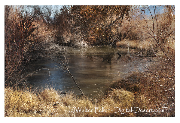
Three short, sad notes the Mourning doves call to each other from bunches of thick green leaves in the cottonwood trees. The heat pushes up the canyon, and the bright sun chases the shadows into themselves the way a mirage disappears as you approach.
Boots crunched softly in the thick sand along the trail and spotted lizards dart frantically in the low scrub. The pointed ears of a coyote catch your attention as it leaps over a clump of gray grass to pounce on a squirrel eating a seed. A tortoise marches on steadfastly and fearless in his search for a mate. A cottontail nibbles on a juicy young leaf and listens closely to every scratch and pop.
The late morning finally gives way, and high noon approaches as bold as a bully. The air is clear and hot. The sun burns the back of your hands, bringing salt to your dry lips. Your forehead tingles; you push the brim of your hat back and tilt your head forward a bit to keep your face in the shade.
Pancho Barnes was an extraordinary pilot and a living legend from the early days of aviation. Born over a century ago as Florence Leontine Lowe, she was fierce, witty, and always ready to take on a challenge. In 1930, she shattered Amelia Earhart’s speed record, becoming the fastest woman in the world for a time. Beyond setting records, she also made her mark as a Hollywood stunt pilot, leaving audiences in awe with her breathtaking aerial acrobatics for the cameras.
But Pancho Barnes didn’t stop there. She started the first stunt pilots’ union and the Happy Bottom Riding Club, a place to hang out near Edwards Air Force Base. Aviators and Hollywood stars loved it. Her ranch became legendary, and test pilots would visit regularly, including those who broke the sound barrier.
Pancho lived life on her terms and never buckled to society. That’s why she’s so important and loved in aviation history. Her story is strength and adaptability personified – the adventurous and pioneering spirit of the early flyers.
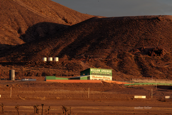
Willow Springs Raceway, also known as Willow Springs International Motorsports Park, stands as a storied institution in the world of motorsports. Located in Rosamond, California, this iconic racing facility has been a cornerstone of American racing since its inception in 1953. Known affectionately as “The Fastest Road in the West,” Willow Springs boasts a rich history, diverse tracks, and a reputation for challenging and exhilarating racing.
Ford -vs Ferrari
A Storied History
Founded by a group of racing enthusiasts led by Bill Huth, Willow Springs Raceway opened its doors in November 1953 with its inaugural race, quickly establishing itself as a premier racing destination. Over the decades, the track grew in popularity and prestige, attracting top racers and becoming a hub for automotive testing and media production.
Famous Figures and Vehicles
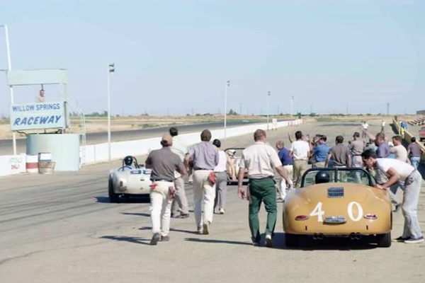
Willow Springs Raceway has a storied legacy and has been home to many iconic drivers and vehicles. I’m impressed by the list of notable names who have raced there, including Mario Andretti, Ken Miles, Carroll Shelby, and even James Dean. Steve McQueen was also a frequent visitor.
As for the cars and motorcycles, the list is just as impressive. The Shelby Cobra, Ford GT40, Porsche 911, and Ferrari 250 GTO are all iconic names in the automotive world, and Willow Springs Raceway has hosted them all. And then there are the motorcycles, like the Yamaha YZR500, Honda RC30, and Ducati 916.
Willow Springs has also hosted famous riders like Kenny Roberts, Wayne Rainey, and Nicky Hayden. The track has been a part of many famous moments in racing, and it continues to offer a challenging and exhilarating experience for drivers and spectators alike.
Diverse and Challenging Tracks
Willow Springs Raceway is a storied institution in the world of motorsports, known for its high-speed straights and challenging corners. The main track, Big Willow, is ideal for those who enjoy an adrenaline rush. But Willow Springs Raceway is home to several tracks, each catering to different types of racing and experience levels.
Streets of Willow is a smaller, technical course, while Horse Thief Mile is favored by drifting enthusiasts and time attack events. The Willow Springs Kart Track is perfect for those who want to test their skills in a competitive environment. Whether you’re looking for speed or technique, Willow Springs Raceway has a track to suit your needs.
Endurance Racing and Top Races
One of the most significant events in the track’s history is the Willow Springs 24-Hour Endurance Race. This grueling event tests both the durability of vehicles and the stamina of drivers, attracting a diverse field of competitors from professional teams to amateur racers. While not held annually, endurance races remain a highlight, showcasing the track’s versatility and challenge.
Other top races include SCCA national races, NASA events, and the Willow Springs Motorcycle Club (WSMC) races. The track has also hosted the Toyota Pro/Celebrity Race and various vintage racing events, adding to its reputation as a premier motorsports venue.
Accidents and Safety
Willow Springs Raceway has experienced its fair share of accidents over the years. Other incidents have occurred during private track days and club racing events. Despite these challenges, the raceway has continually made safety improvements. These include enhanced barriers, runoff areas, and emergency response protocols to ensure a safe environment for all participants.
Conclusion
Willow Springs stands as a testament to the enduring appeal and excitement of motorsports. It has a rich history and diverse tracks, and it continues to attract top racers, automotive enthusiasts, and fans from around the world. With its challenging racing environment and diverse and thrilling experience for drivers and spectators alike, it’s no wonder that Willow Springs remains a beloved and iconic racing facility. It’s a great place to learn how to race, test your skills, and watch professionals.
Stagecoach relay stations and accommodations were vital for the stagecoach travel system, especially during the 18th and 19th centuries. These stations were strategically located along stagecoach routes to ensure efficient travel and the well-being of passengers, horses, and drivers.
Relay Stations
Relay stations, also known as “staging posts” or “stage stops,” were positioned every 10 to 20 miles along the route. Their primary purpose was to provide fresh horses for the stagecoach, as they would be exhausted after traveling long distances. At these stations, tired horses were replaced with rested ones, ensuring the stagecoach could maintain a steady pace without long delays.
Key features of relay stations included:
Stables: For housing and caring for horses.
Feed and Water: Ample supplies of food and water for the horses.
Blacksmith Services: For shoeing horses and making necessary repairs to the stagecoach.
Shelter: Basic accommodations for passengers if they need a brief rest.
Accommodations
Beyond just relay stations, more substantial accommodations were often provided at larger intervals or significant points along the route. These accommodations varied widely, ranging from simple inns to more elaborate hotels, depending on the route’s location and prominence.
Key features of stagecoach accommodations included:
Sleeping Quarters: Rooms for passengers to rest overnight, often shared with other travelers.
Dining Facilities: Meals were provided, typically hearty and designed to sustain travelers for the next leg of their journey.
Lounge Areas: Common rooms where passengers could relax, socialize, and recover from the journey.
Washrooms: Basic facilities for washing up, although these were often quite rudimentary by modern standards.
Repair Services: Facilities to fix any damage to the stagecoach or passenger belongings.
The Experience
Traveling by stagecoach was often uncomfortable and tiring. Roads could be rough, and the constant need to change horses meant frequent stops. However, relay stations and accommodations provided necessary breaks and a chance for passengers to stretch their legs, eat, and rest. These stops were crucial for the safety and efficiency of the stagecoach system, making long-distance travel more manageable during this era.
Despite the hardships, stagecoach travel was an essential part of life, enabling communication, commerce, and transportation across vast distances before the advent of the railroad and the automobile.
Overview of Desert Stagecoach Lines Before Railroads
Before railroads revolutionized transportation, stagecoaches were a critical means of public transport across the desert regions. Here are some key stage lines and their operations:
Goldfield Stage (1905): This stage provided transportation services in the Goldfield area.
Applewhite’s Stage: This stage used a three-bench buggy to transport miners from Calico to town for business and lodging.
Arizona Overland Mail (1866-1868): Initially, it was a weekly mail service from Camp Drum to Prescott, Arizona, which later became twice-weekly. It overcame significant challenges, including Indian troubles.
Barnwell to Death Valley Route: A daily stage route from Barnwell to Manse, Nevada, that remained crucial for travelers and miners even after the completion of the Salt Lake Railroad.
Barnwell to Searchlight Stage Line: Operated until 1906 when the Barnwell & Searchlight Railroad commenced.
Black Canyon Stage Station: A stop for the Panamint Transportation Company along the Black Canyon route.
Brooklyn Well: A stage stop on the Dale to Amboy route, providing necessary water and rest.
Butterfield Overland Stage Company (1858-1860): A major mail route running from Missouri to California, passing through the Mojave Desert.
Calico Stage Line (1): Operated between Daggett and Calico from 1885 to 1887 using a six-horse Concord Coach.
Calico Stage Line (2): Provided twice-daily trips between Calico and Daggett with improved coaches and horses.
California Southern Stage Line: Connected Calico with Barstow and San Bernardino.
Cottonwood Stage Station: A notable station that was raided in 1875 by Cleovaro Chavez’s gang.
Crackerjack Auto Transit Company (1907): Introduced auto-stage services between Silver Lake and Crackerjack.
Daggett & Skidoo Stage Line: Operated through Black Canyon.
Dale to Amboy Stage Line (1903-1916): Known as the Buckboard Stage, this line included lunch in its $5 fare.
Death Valley Chug Line (1907): An auto-stage operated by “Alkali Bill” Brong, transporting passengers around Death Valley.
Domingo Stage & Freight (1887): Ran from Providence to Fenner, primarily hauling ore.
Goldstone-Los Angeles Auto Stage: Provided bi-weekly trips between Los Angeles and Goldstone.
Harrison’s Calico Express Line (1882): Connected San Bernardino with Calico, taking a day and a half each way.
Huntington Stage: The first public transport service between San Bernardino and Calico.
Livingstone & Cahill Stage Line: Operated between Barstow, Daggett, and Calico.
Mecham’s Panamint Stage (1874): Charged $30 for a one-way trip from San Bernardino to Panamint.
Nipton & Searchlight Stage Line (1910): Transported passengers and freight between Searchlight and the railroad at Nipton.
Orange Blossom Mining & Milling Company Stage Line (1908): Served the Orange Blossom mines and camp.
Panamint Transportation Company (1873-1874): Ran from San Bernardino to Panamint City, a challenging and critical route for the time.
Perew Auto Stage (1905): An innovative auto-stage line from Manvel to Searchlight.
Pioneer Stage (1890s): Charged $2 for a 5-mile trip from Manvel into Vanderbilt.
These stagecoach lines were essential in connecting remote areas and facilitating commerce, mail delivery, and passenger transport before the widespread advent of railroads. They navigated rough terrain, faced threats from bandits, and dealt with challenging weather conditions to keep the region connected.
The Butterfield Overland Mail was a pioneering mail and passenger service that operated from 1858 to 1861. It was established by John Butterfield, who won a federal contract to transport mail twice a week between St. Louis, Missouri, and San Francisco, California, in 25 days or less. This service, known as the Butterfield Overland Trail, was crucial in connecting the eastern United States with the burgeoning populations on the West Coast. The route’s significance to California, in particular, cannot be overstated, as it facilitated communication, commerce, and the integration of the state into the broader national framework.
The Establishment of the Route
In 1857, the U.S. Congress awarded Butterfield a $600,000-a-year contract to establish an overland mail route. This contract was the largest land-mail contract ever awarded in the United States at the time. The route began from two eastern termini on the Mississippi River at St. Louis, Missouri, and Memphis, Tennessee. It converged and followed a southerly course through Missouri, Arkansas, Texas, New Mexico, and Arizona before heading north through California to its western terminus in San Francisco. The southern path, known as the Oxbow Route, was chosen to avoid the harsh winter conditions of the Rocky Mountains.
Challenges and Operations
The undertaking was enormous. In association with the principals of Wells Fargo & Co., Butterfield invested over a million dollars to organize the stage line. This investment covered building or repairing roads and bridges, establishing and staffing about 150 stations, and purchasing stagecoaches, wagons, horses, mules, and feed. Additionally, water wells had to be dug, and mountain passes had to be cleared. The route’s operation required the coordination of 800 employees, from drivers and station keepers to blacksmiths and cooks.
Travel along the Oxbow Route was by stagecoach, which left twice a week carrying passengers, freight, and mail. The stagecoaches averaged 100 miles daily, ensuring that mail could be delivered to San Francisco within 25 days. Despite the logistical challenges, including the lack of water and conflicts with Native American tribes, the Butterfield Overland Mail managed to operate remarkably efficiently.
California’s Segment of the Route
The California segment of the Butterfield Overland Trail was particularly significant. After crossing the Colorado River near Fort Yuma, the route entered California and proceeded through the desert and mountain landscapes. Key stops included Los Angeles, where the stagecoaches resupplied and passengers rested, and San Francisco, the final terminus. The route’s passage through California was essential for integrating the state’s economy and population with the rest of the country.
Impact on California
The Butterfield Overland Mail significantly impacted California’s development. Providing a reliable and relatively fast mail service helped integrate California’s economy with the rest of the nation. The route facilitated commerce, allowing businesses to send and receive correspondence and goods more efficiently. It also enabled more effective governmental communication, which was crucial for the governance and development of the rapidly growing state.
Moreover, the Butterfield Overland Mail played a vital role in shaping California’s social and cultural landscape. The service brought many people, including settlers, businesspeople, and adventurers, who contributed to the state’s diverse population. The stagecoach route also supported infrastructure development, such as roads and stations, which continued to benefit the state long after the service ended.
Challenges and Legacy
Despite its success, the Butterfield Overland Mail faced numerous challenges. The harsh desert and mountain environments, the threat of Indian attacks, and the logistical difficulties of maintaining such an extensive route were significant obstacles. The onset of the Civil War in 1861 led to the suspension of the Butterfield Overland Mail as the route was deemed vulnerable to Confederate attacks. The U.S. government rerouted mail delivery to the Central Overland Trail, which was shorter and considered safer.
The legacy of the Butterfield Overland Mail endures as a symbol of American enterprise and determination. It demonstrated the feasibility of a transcontinental mail service and paved the way for future developments in communication and transportation. The route’s influence on California’s integration into the United States and its contribution to its economic and social development are lasting testaments to its significance.
In conclusion, the Butterfield Overland Mail was a monumental achievement in American history. Its establishment and operation represented a significant advancement in communication and transportation, particularly for California. Despite its relatively short operation, the service profoundly impacted the state’s development and integration into the broader national framework. The Butterfield Overland Mail symbolizes the pioneering spirit and the relentless pursuit of progress that characterized the era.
Several pioneering families and individuals significantly influenced the development of the Mojave Desert. Among them were the Stoddard brothers, Lafayette Mecham, Aaron Lane, John Brown Sr., Hieronymous Hartman, the Fears family, the Swarthout family, William Holcomb, Jed Van Duzen, Heber Huntington, and Max Stroebel. These figures played a crucial role in shaping the region’s history through their contributions to infrastructure, mining, ranching, and settlement.
The Stoddard Brothers
Sheldon Stoddard
Arvin and Sheldon Stoddard were instrumental in developing the Mojave Desert. The brothers, originally from Canada, moved to the United States and later settled in San Bernardino. They contributed to the establishment of infrastructure such as wells and roads. Arvin drilled the well-known Stoddard Well, and the brothers created Stoddard Wells Road, reducing travel time and aiding in the region’s development (Desert Gazette) (Desert Gazette) (Digital Desert) (Digital Desert).
Lafayette Mecham
Lafayette Mecham
Lafayette Mecham was awarded a contract in 1867 to transport hay from Little Meadows to Camp Cady. He established a more direct route, which later became part of Stoddard Wells Road, and operated a station at Fish Ponds. His efforts significantly improved transportation and infrastructure in the Mojave Desert (Digital Desert) (Digital Desert).
Aaron Lane
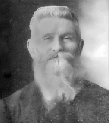
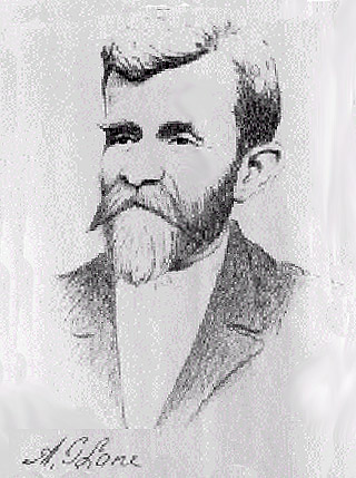
Aaron G. Lane
Aaron G. Lane was the first permanent settler on the High Desert, establishing Lane’s Crossing in 1858. Despite facing numerous challenges, including raids and threats, Lane’s settlement became a crucial waypoint for travelers and military missions, contributing to the early development of the area (Mojave Guide) (Mojave Guide).
John Brown Sr.
John Brown Sr. built a toll road through the Cajon Pass in 1861, facilitating the movement of goods and people. This road, known as Brown’s Toll Road, was essential for travelers and significantly impacted the region’s development. Brown also engaged in trade with local Native American tribes and operated a ferry at Fort Mojave (Mojave Guide) (Desert Gazette) (Digital Desert).
Hieronymous Hartman
Hieronymous Hartman, also known as Hiram Hartman, was a rancher and prospector involved in significant mining operations, including the Hartman Tungsten Mine. Despite his contributions to the local economy, Hartman had a controversial reputation. He was a storekeeper in Calico, a booming silver mining town in the 1880s. Hartman was imprisoned for bigamy in 1900, and his wife died before his release, ironically leaving him her estate. Hartman was later killed in 1908 by Stanley Houghton, who was acquitted, indicating Hartman’s unpopularity in the community (Mojave Guide) (Mojave Guide) (Mojave History) (FindAGrave) (Southwest Parks) (CampReview).
The Fears Family
The Fears family, led by James “Uncle Jim” Fears, were significant settlers in the Cajon Pass during the 1860s. They established a way station that served travelers, providing essential services and facilitating commerce. James Fears later moved to Spadra and remained there until his death (Digital Desert) (Buckthorn Publishing) (Digital Desert).
The Swarthout Family
The Swarthout family arrived in San Bernardino in 1851 and established themselves as prominent ranchers. Nathan, Albert, Truman, and George Swarthout owned large tracts of land and raised cattle, with the Swarthout Valley named in their honor due to their significant presence (Wrightwood Historical Society) (Mojave Desert Archives).
William Holcomb
William Holcomb
William F. Holcomb discovered gold in Holcomb Valley in 1860, sparking the biggest gold rush in Southern California history. Holcomb’s discovery brought many prospectors to the area, and Holcomb Valley became a thriving mining community. His contributions to the region’s mining history are commemorated through the valley named after him (Digital Desert) (Mojave Guide) (Digital Desert).
Jed Van Duzen
Jed Van Duzen was a blacksmith who graded a crucial road between the Victor Valley and the San Bernardino Mountains. In 1874, he was contracted to carry the U.S. Mail from San Bernardino to Prescott, Arizona, ensuring weekly postal delivery to the Mojave River Settlement. His road played a significant role in facilitating the transport of goods and mail through the region (SBC Sentinel).
Heber Huntington
Heber Huntington operated a prominent way station in Victorville during the 1870s. He transformed the station into a trading post, providing provisions, ammunition, fresh horses, blacksmithing services, and meals, supporting the needs of travelers and settlers in the Mojave Desert.
Max Stroebel
Maximilian Franz Otto Von Strobel
Max Stroebel purchased the entire Hesperia townsite for cash in 1870. His acquisition and subsequent development efforts contributed to the area’s growth and settlement, supporting the regional economy and infrastructure during a critical period of expansion in the Mojave Desert (SBC Sentinel).
Connections and Overlaps
The pioneers who shaped the Mojave Desert likely knew of each other or interacted due to overlapping activities, periods, and geographical regions.
Hartman’s activities in ranching and mining placed him in proximity to other significant figures in the Mojave Desert, though his controversial reputation set him apart (Mojave Guide) (Mojave Guide) (Mojave History) (FindAGrave).
Holcomb’s gold discovery drew many to the area, likely resulting in interactions with other miners and settlers involved in the desert’s development (Digital Desert) (Mojave Guide) (Digital Desert).
Jed Van Duzen:
Van Duzen’s road construction and mail delivery services connected vital areas, linking him with other pioneers involved in transportation and settlement activities in the Mojave Desert (SBC Sentinel).
Heber Huntington:
The area now Victorville was initially known as Huntington’s Crossing, named after Heber Huntington, a Mormon pioneer who settled there in the mid-19th century. Huntington’s operation of a way station and trading post connected him with travelers and other settlers, making him a significant figure regionally.
Max Stroebel:
Stroebel’s purchase and development of the Hesperia townsite positioned him as a key player in the expansion and economic growth of the Mojave Desert, interacting with other pioneers involved in settlement activities (SBC Sentinel).
Conclusion
These pioneers’ combined efforts significantly impacted the Mojave Desert’s development. Their work in establishing critical infrastructure, supporting community development, and their adventurous pursuits left a lasting mark on the region. Today, their names are commemorated through various landmarks, ensuring their contributions are remembered in the history of the American West.
Nestled in the El Paso Mountains, Cudahy Camp is a historical landmark in the early 20th-century mining industry. From 1923 to 1947, this site was the primary source of pumice used to manufacture ‘Old Dutch Cleanser,’ a widely known cleaning product in the United States. At its peak, the camp employed 12 men who produced 100 tons of pumicite weekly. Today, visitors can explore the remnants of the camp, including concrete foundations and large hollowed-out rooms from the mining operations.
The Evolution of Old Dutch Cleanser
Old Dutch Cleanser’s journey began in 1905 when the Cudahy Packing Company, a meatpacking firm, developed the product to repurpose animal fat. The cleanser, made by combining soap with pumicite, quickly became a household staple due to its effectiveness. The brand’s logo, featuring a Dutch woman chasing dirt with a stick, symbolized cleanliness and helped the product gain widespread recognition.
In the 1920s and 1930s, Old Dutch Cleanser was heavily promoted through advertisements and civic events like “Clean-Up Week,” encouraging community participation in cleaning efforts. These campaigns solidified the product’s place in American homes and contributed to its lasting legacy.
Corporate Changes and Present-Day
In 1955, Purex acquired Old Dutch Cleanser from the Cudahy Packing Company. The brand changed hands again in 1985 when Greyhound Corporation’s Dial division purchased Purex. Despite these transitions, Old Dutch Cleanser remained a trusted cleaning product. It is manufactured by Lavo in Montreal and continues to uphold its reputation for quality (6/2024).
Last Chance Canyon: A Scenic and Historic Site
Last Chance Canyon, part of the El Paso Mountains, is a significant historical and natural site. It offers a unique glimpse into the area’s rich mining history, including the famous Burro Schmidt Tunnel. The canyon features a rugged landscape with geological formations, box canyons, and historical mining sites. This area was heavily mined from the 1890s through the 1920s, with various operations continuing into the late 20th century.
Visitors to Last Chance Canyon can explore the remains of mining camps, such as Bickel Camp and the Holly Ash Mine, alongside the Old Dutch Cleanser mining site. The canyon is also known for its beautiful scenery, including rock-walled sandy canyons and spectacular layered cliffs.
Cultural Significance and Enduring Legacy
Old Dutch Cleanser has significantly impacted American culture, from being featured in popular media to becoming part of civic traditions. Its memorable branding and consistent advertising have made it a recognizable name in household cleaning. The El Paso Mountains and Last Chance Canyon now serve as historical sites, offering a window into the past for those interested in industrial history and heritage.
Isaac Asimov’s Three Laws of Robotics is a set of fictional principles designed to govern robots’ behavior and ensure their safe interaction with humans. These laws are:
A robot may not injure a human being or, through inaction, allow a human being to come to harm.
A robot must obey the orders given it by human beings, except where such orders would conflict with the First Law.
A robot must protect its own existence as long as such protection does not conflict with the First or Second Law.
Although practical implementation is challenging, Asimov’s laws provide an interesting conceptual framework for current AI engines. Here’s how current AI technologies align with or diverge from these laws:
Current State of AI and Robotics
Safety and Non-Harm (First Law):
Alignment: AI systems, especially in critical applications like autonomous driving, medical diagnostics, and industrial robots, are designed with numerous safety protocols to prevent harm. For example, autonomous vehicles have sensors and algorithms to avoid collisions.
Challenges: Ensuring that AI does not inadvertently cause harm is difficult. Issues like biased decision-making in AI algorithms can lead to harmful outcomes. Moreover, defining and predicting all possible harmful scenarios is complex.
Obedience to Humans (Second Law):
Alignment: Many AI systems are designed to follow human instructions. Virtual assistants like Siri or Alexa respond to user commands, and industrial robots follow programmed tasks.
Challenges: Conflicts can arise when human commands are unethical or dangerous. Current AI lacks the nuanced understanding to refuse harmful orders intelligently. Additionally, AI systems can be manipulated or hacked to follow malicious instructions.
Self-Preservation (Third Law):
Alignment: AI and robotic systems have built-in mechanisms to maintain functionality, such as self-diagnostics and error correction. Autonomous systems like drones or robots are programmed to avoid damaging situations.
Challenges: Prioritizing self-preservation without conflict with human safety and obedience is complex. Balancing these aspects requires sophisticated decision-making capabilities that current AI systems do not fully possess.
Practical Considerations
Ethical and Legal Frameworks: Governments and organizations are developing ethical guidelines and regulations to ensure AI safety and ethical behavior. Examples include the EU’s AI Act and the IEEE’s guidelines for ethically aligned design.
Transparency and Accountability: It is crucial to ensure that AI decisions are transparent and systems are accountable. Explainable AI (XAI) is a growing field focused on making AI decision-making processes understandable to humans.
Advanced Research: Research in AI safety, such as AI alignment and robustness, is ongoing to address AI systems’ limitations and potential risks.
Conclusion
While Asimov’s laws provide a valuable philosophical lens through which to view AI safety and ethics, current AI technologies are not yet fully advanced enough to embody these principles. Ongoing research, ethical guidelines, and regulatory frameworks are essential to move closer to the ideals proposed by Asimov.
A tarantula is a large, hairy spider. Here are some key features to help you visualize it:
Size: Depending on the species, Tarantulas can have a leg span ranging from 4.5 inches to over 11 inches, making them one of the larger spider species.
Body: Spiders have two main body parts. The front part, called the cephalothorax, contains the eyes, mouth, and legs. The back part, the abdomen, is more rounded and houses the spider’s vital organs.
Legs: They have eight legs, which are long, jointed, and covered in hair. The hairs help them sense their environment and capture prey.
Color: Depending on the species, their coloration can vary widely, ranging from brown and black to more vibrant hues like blue or red.
Hair: Tarantulas are known for being very hairy. These hairs are not just for show; they serve various purposes, such as sensing vibrations and, in some species, being used as a defense mechanism by flicking them at potential threats.
Eyes: They have multiple small eyes, usually clustered together. Despite having many eyes, their vision is generally poor, and they rely more on touch and vibrations.
Fangs and Venom: Tarantulas use large, powerful fangs to inject venom into their prey. While their venom is potent enough to subdue insects and small animals, it is generally not dangerous to humans, though a bite can be painful.
Behavior: They are typically solitary creatures and are most active at night. They can be found in various habitats, from tropical rainforests to deserts.
Tarantulas are often misunderstood due to their size and appearance, but they play a vital role in their ecosystems by controlling insect populations.
Describe a tarantula to someone with some previous knowledge
A tarantula is a member of the Theraphosidae family, known for their large size, hairy bodies, and diverse coloration. They are spread across various habitats, including tropical rainforests, deserts, and grasslands. Here are some details that build on basic knowledge:
Size and Structure: Tarantulas are among the largest spiders, with some species, like the Goliath birdeater (Theraphosa blondi), reaching leg spans up to 11 inches. Their bodies are divided into the cephalothorax and abdomen, with the former housing their multiple eyes, chelicerae (fangs), and pedipalps.
Sensory Adaptations: Despite having multiple eyes, tarantulas have poor vision and rely heavily on their setae (hair) to detect vibrations and chemical signals in their environment. These hairs also aid in climbing and handling prey.
Venom and Biting: While all tarantulas possess venom, their bites are generally not dangerous to humans, akin to a bee sting in terms of pain and symptoms. They use their fangs primarily for hunting, injecting venom to immobilize and pre-digest their prey.
Defensive Behaviors: Many New World tarantulas possess urticating hairs on their abdomen, which they can flick at potential predators, irritating. Old World tarantulas, lacking these hairs, are more prone to defensive posturing and biting.
Reproduction: Tarantula mating involves intricate courtship rituals. Males typically transfer sperm to the female using specialized pedipalps. After mating, females lay eggs in a silken sac and guard it until the spiderlings hatch.
Molting: Like all arachnids, tarantulas undergo molting to grow. This process involves shedding their exoskeleton and can take several hours. During molting, they are vulnerable and often reclusive.
Lifespan: Female tarantulas generally have longer lifespans, living up to 20 years or more in captivity, whereas males often live only a few years post-maturity.
Habitat and Burrowing: Many tarantulas are ground-dwelling and construct burrows for protection and hunting. These burrows can be lined with silk, providing stability and a retreat from predators.
Understanding these aspects gives a deeper insight into tarantulas’ fascinating and diverse world.
Describe tarantula to an expert
Tarantulas, members of the family Theraphosidae, exhibit a remarkable diversity in morphology, behavior, and ecology, making them a subject of significant interest within arachnology. Here are some key aspects relevant to an expert:
Morphology
1. Size and Dimorphism:
Tarantulas exhibit significant size variation, with the largest species, such as Theraphosa blondi and Lasiodora parahybana, achieving leg spans up to 30 cm.
Sexual dimorphism is prominent, with females typically larger and more robust, while males are more gracile with longer legs.
2. Setation and Sensory Structures:
Tarantulas possess a dense covering of setae, serving multiple functions from mechanoreception to defense (in the form of urticating hairs in New World species).
Specialized sensory setae, such as trichobothria, are crucial for detecting air currents and vibrations.
Venom and Chelicerae
1. Composition and Function:
The venom of tarantulas, composed of a complex mixture of neurotoxins, proteolytic enzymes, and other bioactive compounds, primarily targets invertebrates but can cause significant pain and local effects in humans.
Cheliceral musculature and fang mechanics are adapted for delivering venom and masticating prey, with variations observed across different genera reflecting ecological adaptations.
Behavior and Ecology
1. Defensive Strategies:
New World tarantulas utilize urticating hairs, with different species exhibiting variations in hair type and deployment strategies, ranging from flicking to passive release.
Old World species, lacking urticating hairs, exhibit more aggressive defensive behaviors, including stridulation and rapid striking.
2. Habitat Specialization:
Tarantulas occupy a range of ecological niches, from arboreal habitats (e.g., Avicularia spp.) to fossorial environments (e.g., Haplopelma spp.), with corresponding morphological and behavioral adaptations.
Burrowing species construct elaborate retreats lined with silk, exhibiting behaviors such as plug-making and tunnel reinforcement, which are crucial for thermoregulation and predator avoidance.
Reproduction and Life Cycle
1. Courtship and Mating:
Courtship behaviors are highly species-specific, involving complex tactile and vibrational signals. Males use specialized structures like tibial apophyses to secure the female during copulation.
Post-mating, females exhibit maternal behaviors, including egg sac construction, guarding, and in some species, communal care of spiderlings.
2. Molting and Growth:
Tarantulas undergo periodic molting, a process regulated by hormonal cycles (ecdysteroids), with frequency decreasing as they mature.
During ecdysis, tarantulas are vulnerable to predation and environmental stressors, necessitating secure, humid environments for successful molts.
Conservation and Research
1. Population Dynamics and Threats:
Habitat destruction, climate change, and the pet trade pose significant threats to tarantula populations, necessitating conservation efforts focused on habitat preservation and sustainable trade practices.
Research on tarantula venom has revealed potential biomedical applications, including novel painkillers and antimicrobial agents, highlighting the importance of preserving these arachnids for future scientific discoveries.
These aspects provide a comprehensive overview of tarantulas, emphasizing their complexity and the ongoing need for research to understand their biology and ensure their conservation.
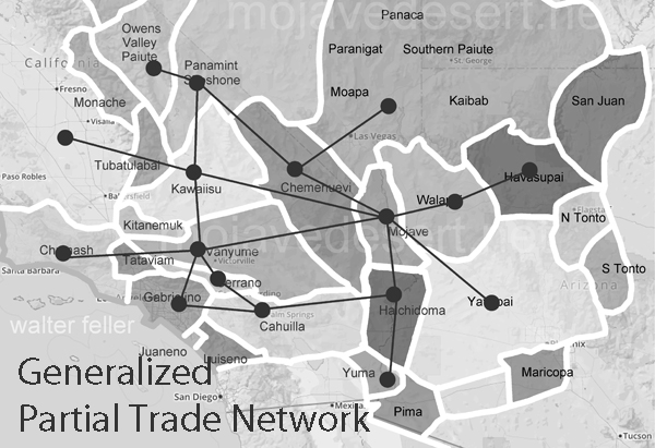
The Mojave Desert, an expansive arid region spanning southeastern California and parts of Nevada, Arizona, and Utah, is more than just a vast, desolate landscape. It is a land imbued with a rich cultural history, much of which is etched into the ancient Indian trails that crisscross its terrain. These trails are a deep connection to the land possessed by the indigenous peoples who once called this desert home.
Historical Significance
.
The Indian trails of the Mojave Desert were primarily created and used by Native American tribes such as the Mojave, Chemehuevi, and Southern Paiute. These tribes utilized the trails for various purposes, including trade, communication, and seasonal migration. The network of trails facilitated the exchange of goods like pottery, shells, foodstuffs, and obsidian, linking the Mojave Desert with coastal and inland regions. This trade network was integral to the economy and culture of the tribes, allowing for the spread of ideas, technologies, and cultural practices.
The trails were not merely utilitarian. They often held spiritual and cultural significance, following natural landmarks and water sources. Sacred sites, ceremonial grounds, and essential gathering places were often along these trails. This cultural layer adds depth to understanding these pathways, illustrating how they were interwoven with the people’s social and spiritual lives.
The Old Spanish Trail
One of the most notable trails is the Old Spanish Trail, which later became a significant route for Spanish explorers and settlers in the 18th and 19th centuries. Blazed initially by Native Americans, this trail stretched from Santa Fe, New Mexico, to Los Angeles, California. The Spanish utilized these established paths to connect their colonial holdings, facilitating trade and the movement of people and goods. The trail highlights the continuity of use by various cultures over centuries, transforming from an indigenous trade route to a significant conduit of colonial expansion.
The Old Spanish Trail was a challenging route, traversing some of the harshest landscapes in North America. Its use by both Native Americans and later Spanish settlers underscores the adaptability and resourcefulness required to navigate the Mojave Desert.
Adaptation to the Desert Environment
The Indian trails of the Mojave Desert showcase the adaptive strategies of Native Americans to the harsh desert environment. The tribes identified and utilized natural springs and seasonal water sources, ensuring safe passage across the expansive and often unforgiving terrain. These water sources were crucial, as they provided the necessary hydration points along the trails. Knowledge of these water sources was passed down through generations, often guarded closely as essential survival information.
The trails frequently ran along the base of mountain ranges and through passes, providing more accessible routes than the open desert. These paths took advantage of the natural topography to offer shade, easier walking conditions, and strategic viewpoints. The trails also connected various ecological zones, allowing the tribes to exploit various resources, from desert plants to mountain game.
Cultural Legacy
Today, the Indian trails of the Mojave Desert are an integral part of the region’s cultural heritage. Many of these trails are preserved and studied by archaeologists and historians, offering insights into the historical movements and lifestyles of the indigenous populations. Modern-day hikers, historians, and cultural enthusiasts retrace these paths, gaining a deeper understanding of the rich history and enduring legacy of the Native American tribes who first navigated the vast Mojave Desert.
Preservation efforts are crucial in maintaining these historic routes. Many trails are threatened by modern development, off-road vehicle use, and natural erosion. Organizations dedicated to preserving Native American heritage work tirelessly to document and protect these trails, ensuring they remain a living testament to the ingenuity and resilience of the desert’s original inhabitants.
Contemporary Relevance
In recent years, interest has been resurgent in these ancient trails. Educational programs, guided tours, and cultural heritage projects aim to bring the stories of these paths to a broader audience. Indigenous groups also play a vital role in these efforts, sharing their knowledge and perspectives to preserve and respect the trails as sacred cultural sites.
The trails also offer lessons in sustainable living and environmental stewardship. The indigenous peoples of the Mojave Desert thrived in a harsh environment through a deep understanding of the land and its resources. Their trails remind us of the importance of living in harmony with nature, an increasingly relevant lesson today.
Conclusion
The Indian trails of the Mojave Desert are more than just paths across the sand; they are the veins of a rich cultural heritage, connecting the past with the present. They tell stories of trade, migration, survival, and spiritual journeying etched into the desert’s landscape. As we explore and preserve these trails, we honor the legacy of the Native American tribes that first navigated the Mojave Desert, ensuring that their stories and knowledge continue to inspire and educate future generations.