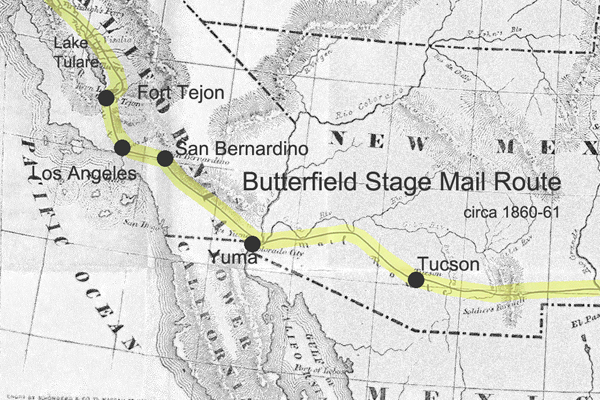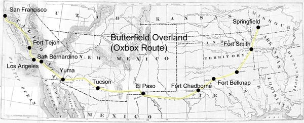
The Butterfield Overland Mail Route was a historic transportation route in the mid-19th century that played a crucial role in connecting the eastern and western parts of the United States.

Here are some key points about the Butterfield Overland Mail Route:
- Establishment: The Butterfield Overland Mail Company was awarded a government contract in 1857 to establish and operate a stagecoach and mail route between St. Louis, Missouri, and San Francisco, California. The purpose of the route was to improve communication and transportation between the two coasts, especially in light of the California Gold Rush.
- Route: The route covered approximately 2,800 miles and passed through eight present-day states: Missouri, Arkansas, Oklahoma, Texas, New Mexico, Arizona, California, and Oregon. It traversed various terrains, including deserts, mountains, and plains.
- Frequency and Duration: The Butterfield Overland Mail Company operated its stagecoaches twice a week in each direction, and the journey took about 25 days to complete. This significantly improved travel time compared to other methods available at the time.
- Stations and Stops: The company established a series of stations along the route to facilitate the long and arduous journey, spaced about 20-30 miles apart. These stations provided fresh horses, food, and accommodations for passengers and drivers. Some of these stations eventually became important settlements in their own right.
- Challenges: The route faced numerous challenges, including harsh weather conditions, difficult terrain, and the threat of attacks from Native American tribes. The company had to implement security measures to protect passengers and mail.
- End of Operations: The Butterfield Overland Mail Route faced financial difficulties exacerbated by the onset of the Civil War. 1861, the service was suspended, and the stagecoaches and stations were abandoned. The route became less relevant as the transcontinental railroad was completed after the Civil War, offering faster and more reliable transportation.
- Legacy: While the Butterfield Overland Mail Route was relatively short-lived, its legacy persists. The route contributed to the United States’s westward expansion and shaped the development of communities along its path. Some old stations have been preserved as historic sites, and portions of the route have been designated the “Butterfield Overland Mail Route.”
The Butterfield Overland Mail Route remains an important chapter in the history of westward expansion and transportation in the United States during the mid-19th century.
https://mojavedesert.net/stagecoaches/
https://mojavedesert.net/mojave-desert-indians/
https://digital-desert.com/historic-roads/
- Butterfield Overland Mail (or Oxbow Route):
- The Butterfield Overland Mail was a stagecoach and mail delivery service that operated from 1857 to 1861. It was a vital communication and transportation link between the eastern and western United States.
- The route covered approximately 2,800 miles, connecting St. Louis, Missouri, and San Francisco, California. It passed through several states, including Missouri, Arkansas, Texas, New Mexico, Arizona, and California.
- The term “Oxbow” might not be directly associated with the Butterfield Overland Mail but could be a local or regional name for a section of the route or a specific location along the way.
- Overland Stage Route:
- The Overland Stage Route, on the other hand, generally refers to the network of stagecoach routes that existed in the western United States during the 19th century. These routes were crucial for mail delivery, transportation of passengers, and freight.
- The most famous of these stagecoach lines was the Butterfield Overland Mail, but there were other stage lines as well, such as the Central Overland California and Pikes Peak Express Company (C.O.C. & P.P.), which operated a route known as the “Pony Express.”
