Wrong-Way River

by walter feller

Mojave River

In 1852 a survey was made of the southwestern edge of the Mojave Desert. The Old Spanish Trail # had become a wagon road bringing thousands of pioneers to the west and developed as a supply route between Los Angeles and Salt Lake City. The survey was as accurate as any at that time and followed the trail from near the top of the Cajon Pass to a point where the trail leaves the Mojave River near Fishponds. The trail to Salt Lake continues north as we know it, but the river flowing east on this map bears southeast and empties into the Colorado River. At the time it was thought the Mojave (spelled Mohahve on the map) River followed this course. It did not. There was no Mojave Road in 1852 and not many Americans had traversed that portion of the desert. As we now know the Mojave River cuts through Afton Canyon and then disappears into the sink of the Mojave before it reaches Soda Lake.

The Williamson survey the next year in 1853 begins to correct the true ancient course of the river as it would have found its way to converge with the Amargosa River and empty into Death Valley’s Lake Manly via Soda Lake, Silver Lake, Silurian Lake, and Salt Springs.

-End –

Indian Queho.

Standing second from the left is Frank Waite, chief of police in Las Vegas for many years. Waite was a member of the posse that initially searched for Queho.

Subject: – – Mummified remains of an Indian renegade known as Queho. Many years previous to when this photo was taken in the early 1940s, Queho is said to have killed and robbed a number of individuals in the Searchlight, Nevada area. Unsuccessful efforts were made to apprehend Queho.

In the early 1940s, the men pictured here on the left and right were exploring an area along the Colorado River when they saw a cave in the cliffs above the river. they climbed up to the cave and Queho’s remains were found. Research had established that the remains were Queho’s because several of the artifacts he had stolen from people in Searchlight accompanied the remains.

Queho’s remains were turned over to the Palm Mortuary in Las Vegas when a question arose as to who would pay for the expenses of keeping Queho there and his burial. Roland Wiley, district attorney for Clark County, Nevada, at the time, suggested that the remains be turned over to the Elks Lodge, where for a number of years they were exhibited on the Heldorado grounds during Heldorado days in a glass display case with some of the stolen artifacts.

Queho’s remains were stolen from the Elks on 2 occasions, and each time they were recovered. Jim Cashman, head of the Las Vegas Elks at the time, grew tired of worrying about the theft of Queho’s remains so they were moved to a building belonging to Dobie Doc Caudil near the Tropicana Hotel.

Subject: A view of the suspension bridge and the statue of Christ at Cathedral Canyon, Pahrump Valley, Nevada, in the late 1980s. The statue, carved of rock, is a small replica of the Christ of the Andes installed in the Andes Mountains on the border between Argentina and Chile in the early part of the 20th century. The replica was made by an artist from Ajijic, a small town south of Guadalajara, Mexico. Wiley constructed the suspension bridge about 1973. In 1989, approximately 1,000 people a month visited Cathedral Canyon. Roland Wiley is seated in the picture; the man standing in the white shirt is unidentified.

Roland Wiley purchased Queho’s remains from Dobie Doc for $100 and buried them near Cathedral Canyon, located on Wiley’s ranch in Pahrump Valley overlooking his Hidden Hills airstrip, in concrete and steel so they could not be easily stolen again. Wiley believed the Indian deserved a decent burial and buried popcorn with the remains to accompany Queho on his journey.

The Renegade

On February 21, 1940, the banner headline in the Las Vegas Review-Journal— BODY OF INDIAN FOUND— recalled for many in the town memories of the first murder the dead Indian had committed, thirty years earlier at Timber Mountain, just a few miles from Searchlight in the McCullough Range. . . .

Pete Harmon

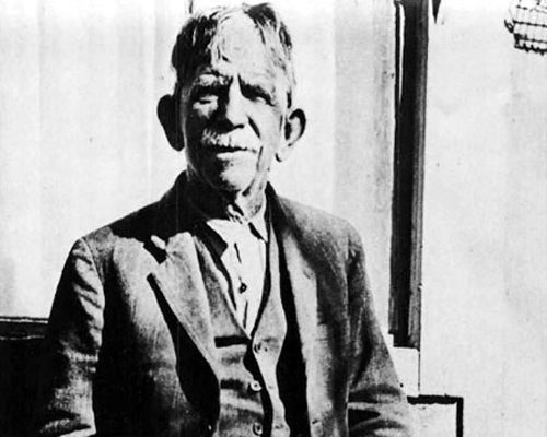
Keep on Steppin’ — The man who walked 481 miles to see a sick friend

. . . At our home he [Shorty Harris] lay on his back for weeks, fed with a spoon. Always talking of putting another town on the map. Always losing a million dollars a day. He was miraculously but slowly recovering when an Associated Press dispatch bearing a Lone Pine date made front page headlines with an announcement of his death.

Though the report was quickly corrected, his presence at our house brought reporters, photographers, old friends, and the merely curious. At the time the Pacific Coast Borax Company’s N.B.C. program was featuring stories based on his experiences over a nation-wide hook-up. Among the callers also were moguls of mining and tycoons of industry who had stopped at the Ballarat cabin to fall under the spell of his ever ready yarns.

Pete Harmon

Among these guests, one stands out.

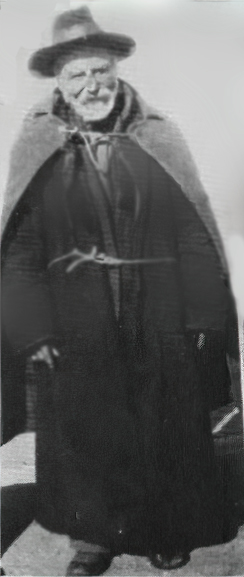
It was a hot summer day when I saw on the lawn what appeared to be a big bear, because the squat, bulky figure was enclosed in fur. Answering the door bell I looked into twinkling eyes and an ingratiating smile. “They told me in Ballarat that Shorty Harris was here.” I invited him in.

“I’ll just shed this coat,” he said, stripping off the bearskin garment. “… sorta heavy for a man going on 80.” He laid it aside. “It’s double lined. Fur inside and out. You see, I sleep in it. Crossed three mountain ranges in that coat before I got here. May as well take this other one off too.” He removed another heavy overcoat, revealing a cord around his waist. “Keep this one tied close. Less bulky….”

Under a shorter coat was a heavy woolen shirt and his overalls concealed two pairs of pants. He went on: “I was with Shorty at Leadville. My name’s Pete Harmon. We ought to be rich—both of us. Why, I sold a hole for $2500 in 1878. Thought I was smart. They’ve got over $100,000,000 outa that hole. I was at Bridgeport when I heard Shorty was sick, so I says, ‘I’ll just step down to Ballarat and see him.’ (The ‘step’ was 298 miles.) When I got there Bob Warnack tells me he’s in Los Angeles. When I get there they tell me he’s with you. So I just stepped out here.”

He had “stepped” 481 miles to see his friend.

Shorty Harris

I ushered him in and left them alone. After an hour I noticed Pete outside, smoking. I went out and urged him to return and smoke inside, but he refused. “It’s not manners,” he insisted.

Later I happened to look out the window and saw him empty the contents of a small canvas sack into his hand. There were a few dimes and nickels and two bills. He unfolded the currency. One was a twenty. The other, a one. He put the coins in the sack and came inside. A few moments later, from an adjacent room I heard his soft, lowered voice: “Shorty, I’m eatin’ reg’lar now and got a little besides. I reckon you’re kinda shy. You take this.”

“No—no, Pete. I’m getting along fine….”

I fancy there was a scurry among the angels to make that credit for Pete Harmon.

Late in the afternoon, Pete donned his coats. “I’d better be going. I’ve got a lotta things on hand. A claim in the Argus. When the money comes in, well—I always said I was going to build a scenic railroad right on the crest of Panamint Range. Best view of Death Valley. It’ll pay. How far is it to San Diego?”

“A hundred and forty miles….”

“Well, since I’m this far along I’ll just step down and see my old partner. Take care of Shorty….” And down the road, he went.

With humility I watched his passage, hoping that the good God would go with him and somehow I felt that of all those with fame and wealth or of high degree who had gone from that house, none had left so much in my heart as Pete.

Adapted from;
Chapter XVII
Shorty Frank Harris
Title: Loafing Along Death Valley Trails
       A Personal Narrative of People and Places

Author: William Caruthers

Protecting the Mojave in 1974

Los Angeles Herald Examiner Photo Collection
Howell, E. Bruce – 1974

Photograph caption dated April 3, 1974 reads, “Shy desert tortoise curls up inside his shell on top of a groove left in desert sand by motorcycle on the Stoddard Valley off-road vehicle racing area of Barstow. Already legally protected as an endangered species, environmentalists and scientists say the threat is heightened along with other desert life by off-road vehicle activities.”

Photograph caption dated April 3, 1974 reads, “Environmentalist group that recently toured the Mojave Desert to show evidence of damage done by indiscriminate use of off-road vehicle say they believe holes on this live desert tortoise shell were caused by bullets.”

Photograph caption dated April 3, 1974 reads, “Tiny marker planted in Mojave Desert at Stoddard Valley, marks U.S. Bureau of Land Management boundary separating approved off-road vehicle race course from a restricted area. Heavy tire tracks on both sides of marker indicate that such markers are virtually ignored, except by desert visitors with guns, who have riddled them with bullets.”

Photograph caption dated April 3, 1974 reads, “Stoddard Valley on Mojave Desert near Barstow, despite its vast openness is a continuous maze of off-road vehicle tire tracks. Federal plan for managing off-road vehicle use on desert has left it open for off-road vehicle races and closed other areas. But environmentalists and scientists say regulations for restricted areas are too vague and open to this kind of damage.”

Photograph caption dated April 3, 1974 reads, “These people seek to defend the vast Mojave Desert from a federal program that regulates off-road vehicles. They claim regulations are vague, unenforceable, and could open the desert to extensive off-road vehicle damage. From left are UC Riverside professors Bill Mayhew, zoology; Sylvia Broadbent, anthropology; and Richard E. Gutting, Jr., attorney for Environmental Defense Fund.”

Photograph caption dated April 3, 1974 reads, “Judith Winder, staffer for Environmental Defense Fund, sketches petroglyph of longhorn sheep from rock in Inscription Canyon.”

Photograph caption dated April 3, 1974 reads, “Hand of UC Riverside anthropology professor, Sylvia Broadbent, points out recent chisel mark at bottom of a chipped out section of volcanic rock which had an ancient Indian carving on it. Such damage to antiquities, which is widespread in the Mojave Desert is illegal. This damage was in Inscription Canyon near Barstow.”

Photograph caption dated April 3, 1974 reads, “Richard E. Gutting, Jr., kneeling, attorney for Environmental Defense Fund, and UC Riverside anthropology professor Sylvia Broadbent, examine off-road vehicle dislocation of ‘desert pavement,’ a dark, rocky covering on desert floor which takes thousands of years to form but is important to the natural balance of desert life. Light swath was made by off-road vehicle race.”

Photograph caption dated April 3, 1974 reads, “Off-road vehicle race course touring party gathers at scene of ancient Indian sleeping circle (foreground), a circular formation of larger rocks in midst of small ones, which anthropologists say were foundations for shelters built by prehistoric Indians. All such sites, they assert, should be protected.”

Photograph caption dated April 3, 1974 reads, “Not just ordinary boulders, these, according to Dr. Sylvia Broadbent, UC Riverside anthropology professor, who said there is no question that the slightly concave rock in the upper half of photo was worn that way by ancient Indians grinding grain and marks on the surface of the rock in the lower photo were also made by the same Indians.”

Photograph caption dated April 3, 1974 reads, “Petroglyphs, ancient Indian rock art, abound on the walls of Inscription Canyon near Barstow. Archaeologists look upon them as valuable keys to unlocking the secrets of prehistoric peoples who inhabited the vast Mojave Desert, but complain they are being destroyed by desert visitors at an alarming rate.”

Photograph caption dated April 3, 1974 reads, “He calls the Mojave Desert ‘home.’ Desert lizard suns itself on dark, porous volcanic rock in Inscription Canyon. Same rocks are covered with ancient Indian petroglyphs, and rock art carvings, indicating the canyon may have been where Indians trapped and captured longhorn sheep and other desert game. The entire canyon is falling victim to vandals and souvenir hunters.”


High Desert Small Atlas

Cajon Pass/Victor Valley Roads

Working copy – not all roads included

1 – Old Spanish Trail/Indian trail (1827)
2 – Cajon Pass (Lower) – Indian trail
3 – Lone Pine Canyon – Indian trail
4 – Sheep Creek – Indian trail
5 – Sanford Pass (c.1854-57)
6 – Fort Tejon – Indian trail
7 – to Mojave River – Indian trail
8 – to Daggett (c.1855)
9 – Lucerne/Cushenbury Lumber road
10 – Van Dusen/Holcomb Valley Road – (1862)
11 – Mojave Indian trail (c.1776, 1826)

Freighting

10-horse freight outfit – R. & J. Reynolds collection

“Freighting” became an important occupation. The man who wished to engage in it must be a considerable capitalist, for the heavy wagons, constructed especially for the purpose, were expensive, and strong, well-broken mules were required. Eight, ten, twelve, and sometimes eighteen or twenty mules or horses were used as motive power for the “outfit.” The wagons were carefully packed, and often carried thousands of dollars worth of merchandise. The driving of one of these “freighters” over the mountains and deserts required forethought, prompt action, and good judgment. There was always danger from the Utes. Apaches and other Indians. The heat and the cold, the alkali dust, the blinding glare of the sun upon the desert sands, thirst and hunger—all of these tested to the uttermost the physical and mental powers of the teamsters.

Ingersoll’s century annals of San Bernadino County, 1769-1904