Comparative Geomorphology

Here’s a comparison between the geomorphology of the Funeral Mountains – Greenwater Valley subsection and the second geomorphological description:

Geomorphology
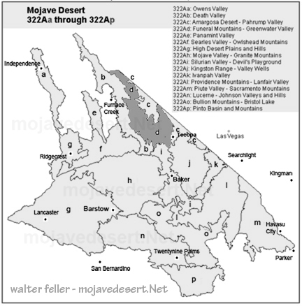
Funeral Mountains and Greenwater Valley

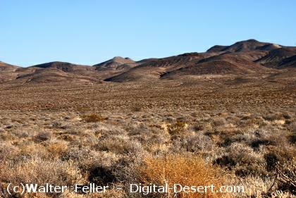
  • Landforms: Steep to very steep mountains and valleys, with very gently to moderately sloping alluvial fans, nearly level basin floors, and dry lake beds.
  • Orientation: Mountains align north-south or north-northwest.
  • Elevation Range: About 1,000 feet to 6,703 feet on Pyramid Peak, with many peaks over 5,000 feet.
  • Geomorphic Processes: Mass wasting, fluvial erosion and deposition, and eolian deflation and deposition.

Geomorphology

Geomorphology is the scientific study of landforms and the processes that shape them, including their origin, evolution, and spatial distribution.

Geomorphology
Lucerne and Johnson Valleys

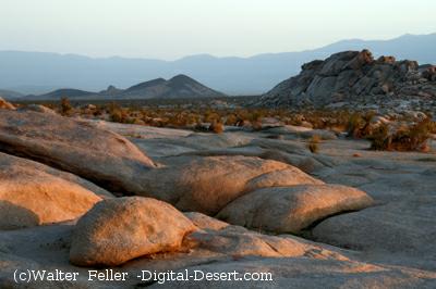
  • Landforms: Steep mountains, moderately steep hills, gently to moderately sloping pediments and alluvial fans, nearly level basin floors, and dry lake beds. Presence of “badlands” on eroded Miocene nonmarine sedimentary rocks.
  • Orientation: The hills’ general orientation is less straightforward than the major faults, which trend northwest.
  • Elevation Range: About 1,600 feet up to 4,873 feet in the Granite Mountains, 5,525 feet in the West Ord Mountains, 6,309 feet in the East Ord Mountains, and 5,878 feet in the Rodman Mountains.
  • Dry Lake Beds: Includes Lucerne, Soggy, Melville, Galway, Emerson, and Deadman Lake.
  • Geomorphic Processes: Mass wasting, fluvial erosion and deposition, and eolian deflation and deposition.
Greenwater Valley, Death Valley National Park

Comparison

  • Landforms: Both regions feature steep mountains and valleys, alluvial fans, basin floors, and dry lake beds. However, the second description includes pediments and mentions “badlands,” which are not noted in the Funeral Mountains – Greenwater Valley description.
  • Orientation: The Funeral Mountains – Greenwater Valley mountains align north-south or north-northwest, while the hills in the second description have a less clear orientation than the major northwest-trending faults.
  • Elevation Range: The Funeral Mountains – Greenwater Valley has a broader elevation range, reaching higher peaks (up to 6,703 feet), whereas the second area reaches 6,309 feet in the East Ord Mountains.
  • Dry Lake Beds: The second description specifies several large dry lake beds by name, which are not mentioned in the Funeral Mountains – Greenwater Valley description.
  • Geomorphic Processes: Both regions experience similar geomorphic processes, including mass wasting, fluvial erosion and deposition, and eolian deflation and deposition.

In summary, while both regions share common geomorphic features and processes, they differ in specific landform characteristics, elevation ranges, and the presence of features such as “badlands” and named dry lake beds.

Geologic Diversity

When someone mentions they are a geologist, it’s easy to assume that all geologists do the same thing. However, geology is a diverse and multifaceted field, encompassing a wide range of specialties. Each geologist may focus on different aspects of the Earth’s structure, materials, processes, and history. Here’s a more detailed look at the various types of geology and the distinct roles that geologists might have:

Types of Geology

  1. Structural Geology: Geologists in this field study the architecture and processes responsible for the deformation of the Earth’s crust. They analyze faults, folds, and rock formations to understand tectonic movements and stress patterns.
  2. Petrology: Petrologists examine the origin, composition, and structure of rocks. They specialize in:
    • Igneous Petrology: Focuses on rocks formed from magma or lava.
    • Sedimentary Petrology: Studies rocks formed by the accumulation of sediments.
    • Metamorphic Petrology: Investigates rocks transformed by heat and pressure.
  3. Mineralogy: Mineralogists study minerals, including their structure, properties, classification, and distribution. They identify and analyze mineral compositions in various geological contexts.
  4. Geochemistry: Geochemists explore the chemical composition of Earth materials and the chemical processes occurring within and on the Earth’s surface. They study element cycles and mineral interactions.
  5. Geomorphology: Geomorphologists study landforms and the processes that shape them. They analyze erosion, weathering, and sediment deposition to understand landscape evolution.
  6. Sedimentology: Sedimentologists focus on sediments and sedimentary rocks, including their formation, transport, and deposition. They study sedimentary environments like rivers, lakes, and oceans.
  7. Paleontology: Paleontologists study fossils and ancient life forms to understand the history of life on Earth. They analyze fossil records to reconstruct past ecosystems and evolutionary trends.
  8. Volcanology: Volcanologists study volcanoes, volcanic processes, and volcanic rocks. They monitor volcanic activity and assess eruption risks.
  9. Seismology: Seismologists study earthquakes and the propagation of seismic waves through the Earth. They analyze seismic data to understand earthquake mechanics and predict future events.
  10. Geophysics: Geophysicists use physical methods to study the Earth’s interior and its physical properties. They specialize in:
    • Seismic Geophysics: Uses seismic waves to map the Earth’s interior.
    • Magnetic Geophysics: Studies the Earth’s magnetic field and anomalies.
    • Gravitational Geophysics: Examines variations in the Earth’s gravitational field.
  11. Hydrogeology: Hydrogeologists study groundwater, its distribution, movement, and quality. They analyze aquifers and manage water resources.
  12. Engineering Geology: Engineering geologists apply geological knowledge to construction and environmental management engineering practices. They assess ground stability and risks for infrastructure projects.
  13. Environmental Geology: Environmental geologists focus on human interaction and the geological environment. They address natural hazards and resource management to mitigate environmental impacts.
  14. Economic Geology: Economic geologists study materials for financial and industrial purposes, such as minerals, oil, and gas. They explore and develop natural resources.
  15. Planetary Geology: Planetary geologists study the geology of other celestial bodies, such as moons, planets, and asteroids. They analyze surface features and geological processes beyond Earth.

Each type of geologist brings unique expertise to their field, contributing to a comprehensive understanding of the Earth’s dynamic systems. Understanding these distinctions helps us appreciate geologists’ specialized skills and knowledge of various challenges and projects.

Summary

Geology is a diverse field with various specialties. Structural geologists study Earth’s crust deformation, while petrologists focus on rock origins and types. Mineralogists analyze minerals, and geochemists explore Earth’s chemical processes. Geomorphologists study landforms, sedimentologists examine sediments, and paleontologists investigate fossils. Volcanologists monitor volcanic activity, seismologists study earthquakes, and geophysicists use physical methods to probe Earth’s interior. Hydrogeologists focus on groundwater, engineering geologists apply geology to construction, and environmental geologists manage natural hazards. Economic geologists explore resources like minerals and oil, and planetary geologists study celestial bodies. Each specialty offers unique insights into Earth’s processes and history.

Parietal Eye

The parietal eye, also known as the third eye, is a part of the pineal gland and is found in some species of reptiles and amphibians. It is a photosensitive organ located on the top of the head and is capable of detecting light and dark. Here are some key points about the parietal eye:

  1. Location and Structure: The parietal eye is situated in the parietal area of the brain, on the top of the head, and it is visible as a small, light-sensitive spot in some reptiles and amphibians.
  2. Function: The parietal eye’s primary function is to detect changes in light intensity, helping the animal regulate its circadian rhythms and hormone production. It can also influence basking, thermoregulation, and seasonal reproduction.
  3. Presence in Species: The parietal eye is found in various species of reptiles, such as some lizards (like iguanas) and tuataras, as well as some species of amphibians and fish. It is not present in birds or mammals.
  4. Evolutionary Aspect: The parietal eye is considered an ancient feature in vertebrate evolution, reflecting an early adaptation to environmental light changes.
  5. Comparison with Pineal Gland: While the parietal eye is light-sensitive, the pineal gland in other vertebrates (including humans) receives light information indirectly through the eyes and the brain. Both structures are involved in regulating circadian rhythms and reproductive cycles.

In summary, the parietal eye is an intriguing evolutionary feature that aids certain reptiles and amphibians in detecting environmental light and regulating physiological functions.

The Parietal Eye: Nature’s Light Sensor

The parietal eye, often called the third eye, is a fascinating feature found in some reptiles and amphibians. This photosensitive organ, located on the top of the head, plays a crucial role in detecting light and dark and aids in regulating various physiological processes.

Structure and Location

The parietal eye is situated in the parietal area of the brain and is visible as a small, light-sensitive spot. Unlike the primary eyes, which detect images, it acts as a direct light sensor. This organ is found in certain lizards (including iguanas), tuataras, and some amphibians and fish. Birds and mammals, however, do not possess this feature.

Function and Role

The primary function of the parietal eye is to detect changes in light intensity, helping the animal maintain its circadian rhythms and regulate hormone production. This detection influences behaviors such as basking, thermoregulation, and seasonal reproduction. By sensing light, the parietal eye helps these animals adapt to their environment, optimizing their physiological and behavioral responses.

Evolutionary Significance

The presence of the parietal eye is an ancient adaptation, reflecting early vertebrate evolution. It showcases how animals have developed specialized organs to respond to environmental changes. While the parietal eye is a direct light sensor, other vertebrates, including humans, rely on the pineal gland for similar functions. The pineal gland receives light information indirectly through the eyes and brain, playing a key role in regulating circadian rhythms and reproductive cycles.

Conclusion

The parietal eye is a remarkable evolutionary feature that underscores the diversity of adaptations in the animal kingdom. By detecting light and dark, it enables reptiles and amphibians to finely tune their behaviors and physiological processes to their environments, ensuring their survival and reproductive success.

Summary

The parietal eye, or third eye, is a light-sensitive organ found in some reptiles and amphibians, situated on the top of the head. It detects changes in light intensity, aiding in regulating circadian rhythms, hormone production, and behaviors like basking and thermoregulation. Present in species such as lizards, tuataras, and some amphibians, this ancient adaptation highlights early vertebrate evolution. Unlike the parietal eye, the pineal gland in other vertebrates receives light information indirectly through the eyes and brain. This unique feature helps these animals optimize their responses to environmental changes, ensuring survival and reproductive success.

Dune Saltation

Dune saltation is a key process in the formation and movement of dunes. It involves the hopping or bouncing movement of sand grains across the surface, driven by wind. Here’s a detailed explanation:

Dune Saltation Process

  1. Initiation: Wind speeds reach a threshold where they can lift sand grains from the ground. This threshold varies depending on the size and weight of the grains, as well as the wind speed and direction.
  2. Lift-off: Sand grains are lifted into the air by the wind. The initial lift is usually caused by the impact of other grains, which creates a chain reaction.
  3. Transport: Once airborne, the grains are carried by the wind. They travel a short distance before falling back to the ground due to gravity.
  4. Impact: When the grains land, they can dislodge other grains, causing them to lift off and continue the saltation process. This impact also leads to the erosion and smoothening of the surface.
  5. Repetition: The cycle of lift-off, transport, and impact continues, causing the sand grains to move in a series of short hops or bounces.

Factors Influencing Saltation

  • Wind Speed: Higher wind speeds increase the distance and height of saltation.
  • Grain Size: Smaller grains are more easily lifted and carried by the wind, while larger grains require stronger winds.
  • Surface Conditions: Smooth surfaces allow for easier saltation, while rough surfaces can trap grains and reduce movement.
  • Moisture: Moisture in the sand can cause grains to stick together, inhibiting saltation.

Impact on Dune Formation

  • Dune Shape: Saltation contributes to the growth and movement of dunes. The continuous movement of sand grains causes dunes to migrate toward the prevailing wind.
  • Sorting of Grains: Saltation can lead to sorting grains by size, transporting finer grains further than coarser ones.
  • Erosion and Deposition: Saltation causes erosion and deposition, shaping the landscape and forming various dune structures, such as crescent-shaped barchan and linear dunes.

Understanding dune saltation is crucial for studying desert geomorphology and predicting changes in dune landscapes.

Dune saltation is the wind-driven process where sand grains are lifted, transported, and deposited in a series of hops. Wind lifts grains into the air, which then travel short distances before falling back, dislodging other grains upon impact. This cycle causes sand to move and shapes dunes. Wind speed, grain size, surface conditions, and moisture influence saltation. Higher wind speeds and smaller grains increase movement, while moisture and rough surfaces reduce it. Saltation contributes to dune formation, migration, and sorting of grains by size, playing a crucial role in desert geomorphology.

Difference between standard and narrow gauge railroads

https://mojavedesert.net/railroads

SP Standard Gauge Engine No. 3203 and Narrow Gauge Engine No. 18 at Owenyo in 1951 – OwensValleyHistory.com

The primary difference between standard gauge and narrow gauge railroads lies in the distance between the two rails, known as the gauge.

Standard Gauge

  1. Definition: Standard gauge is a rail gauge with a distance of 4 feet 8.5 inches (1,435 mm) between the inside edges of the rails.
  2. Prevalence: It is the most widely used rail gauge worldwide, found in approximately 60% of all railway lines.
  3. Advantages:
    • Interchangeability: Standard gauge allows for seamless interchange of rolling stock and locomotives across different regions and countries using the same gauge.
    • Stability and Speed: Standard gauge tracks provide a stable and smooth ride, making them suitable for high-speed trains.
    • Infrastructure: Standard gauge railways often have more extensive infrastructure and better connectivity due to their widespread use.

Narrow Gauge

  1. Definition: Narrow gauge railroads have a rail distance smaller than the standard gauge. Common narrow gauges include 3 feet 6 inches (1,067 mm), 3 feet (914 mm), and 2 feet (610 mm).
  2. Prevalence: Narrow gauge railroads are less common globally but are often used in specific regions, industries, or for particular purposes.
  3. Advantages:
    • Cost-Effective: Narrow-gauge railways are generally cheaper to construct and maintain, making them ideal for regions with challenging terrain or lower traffic volumes.
    • Tighter Curves: Narrow gauge tracks can handle tighter curves and steeper gradients, making them suitable for mountainous or rugged areas.
    • Flexibility: They are often used in industries such as mining, logging, or agriculture, where flexibility and lower costs are more critical than speed and capacity.

Applications

  • Standard Gauge: Used in most major rail networks, including passenger services, high-speed rail, and heavy freight operations.
  • Narrow Gauge: Found in specialized environments such as mountain railways, industrial railways, heritage railways, and some regional lines.

Examples

  • Standard Gauge: Most North American rail networks.
  • Narrow Gauge: The Carson Colorado Railroad (3 feet gauge)

In summary, while standard gauge railroads offer advantages in interoperability, stability, and infrastructure development, narrow gauge railroads provide cost-effective solutions and greater flexibility in challenging terrains or specialized applications.

https://mojavedesert.net/railroads/carson-and-colorado