Palmenthal

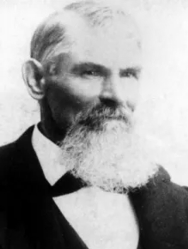
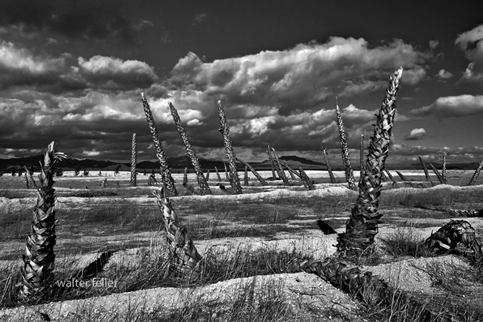
Johann George Ecker led a group of German and Swiss immigrants who settled in the Antelope Valley in 1886, founding a small colony they called Palmenthal—named for the nearby Joshua trees, which they mistook for palms. These settlers sought to establish a self-sufficient farming community on the high desert plain. Drawing from their European roots, they introduced cooperative labor, community organization, and dry-farming methods suited to the arid conditions. Early crops included barley, wheat, and fruit orchards, with irrigation ditches dug by hand to capture scarce water. Despite their determination, drought and isolation made survival difficult, and by the early 1890s, many settlers left. Still, their legacy endured in the renamed settlement of Palmdale, marking the valley’s first organized agricultural community.

Palmenthal was the original German-Swiss settlement that became Palmdale, California. Founded in 1886 by Johann George Ecker and a group of immigrant families from Germany and Switzerland, the colony was located near present-day 20th Street East and Avenue Q. The settlers named it Palmenthal, or “Palm Valley,” after mistaking the native Joshua trees for palms.

They arrived with hopes of building a cooperative farming community, bringing European agricultural practices and traditions with them. Using dry-farming methods, they planted barley, wheat, and fruit orchards, and attempted small-scale irrigation projects to make the desert productive. The settlers built simple homes, a school, and community facilities, establishing the first structured settlement in the Antelope Valley.

Life in Palmenthal was harsh. Repeated droughts, crop failures, and the isolation of the high desert took their toll. Within a few years, many families abandoned the colony, some moving closer to the Southern Pacific Railroad line near Harold, where water and transport were more reliable. By the early 1890s, Palmenthal was largely deserted, but its spirit persisted in the nearby settlement that would evolve into modern Palmdale.

The story of Palmenthal represents the first organized effort to colonize and cultivate the Antelope Valley—an experiment in community and endurance that laid the groundwork for future growth in the region.

Timeline

1886 – Johann George Ecker and a group of German and Swiss immigrants establish the settlement of Palmenthal in the Antelope Valley, naming it for the Joshua trees they mistake for palms.

1887 – The settlers begin dry farming and plant wheat, barley, and fruit orchards. A small schoolhouse and community hall are built.

1888 – Severe drought conditions make farming difficult. Wells yield limited water, forcing the settlers to haul water from distant springs.

1889 – Some families leave the settlement due to crop failures and the isolation of the high desert.

1890 – Remaining settlers attempt to improve irrigation by digging ditches and small reservoirs, but lack of rainfall continues to hinder success.

1891 – The Southern Pacific Railroad establishes a station several miles west, prompting some settlers to relocate closer to the line for better access to supplies and transport.

1892 – Palmenthal is largely abandoned. The remaining residents consolidate around the new rail siding area that becomes known as Palmdale.

1893 – The name Palmdale replaces Palmenthal, marking the transition from the failed colony to the town that would endure.

Arvin Stoddard

Arvin Mitchell Stoddard (1825–1914)

Arvin Stoddard

Born in 1825 in Bastard Township, Leeds County, Upper Canada (now Ontario). He was the son of Nathaniel and Jane Stoddard and brother to Sheldon, Albert, and Rufus. The family later converted to Mormonism and joined the westward migration.

Traveled with a Mormon emigrant company under Charles C. Rich around 1852 to 1853. Reached the Salt Lake Valley in Utah, then continued west into California by the mid-1850s, likely entering through Cajon Pass. Settled in the San Bernardino area with other early pioneers.

Moved into the Mojave region during the late 1850s or early 1860s. Established or drilled Stoddard Well, which became a vital water source for travelers. Helped develop the Stoddard Wells Road, an important freight and emigrant route between Victorville and Barstow. Supported freighting operations and ranching efforts in the Victor Valley. Worked closely with his brother Sheldon, who was also active in transportation and settlement.

Stoddard Wells became a lasting geographic landmark and stop along desert routes. The road provided improved access for mining, settlement, and commerce. His work reflected the hands-on pioneer ethic of building essential infrastructure in difficult terrain. Remembered locally as one of the Stoddard brothers, among the earliest trailblazers of the Mojave Desert.

Remained in Southern California into the late 19th century. Died in 1914. His name endures through landmarks like Stoddard Wells, which commemorate his role in opening the Mojave to travel and settlement.

Arvin’s story illustrates the shift from Mormon settlement to broader regional development across Southern California. His contributions supported the growing network of trails, roads, and water sources that made desert travel possible. He stands as an example of the practical, industrious pioneers who built the foundation for future desert communities.

Sheldon Stoddard
Early pioneer and Mormon settler who helped establish routes, wells, and communities along the Mojave River during California’s frontier expansion.

Upper Mojave River Trail
Historic travel corridor following the upper Mojave River, connecting early settlements, ranches, and stage stops between Cajon Pass and Barstow.

Stoddard Wells Road
Historic wagon route branching from the Mojave River Trail, used by settlers and freighters linking San Bernardino with desert mining districts.

Stoddard Well
A vital water source established by the Stoddard brothers and later maintained by Hiram Hartman, serving travelers and stockmen crossing the high desert.

Pioneers
Early settlers who braved the Mojave frontier, building wells, trails, and communities that shaped the foundation of inland Southern California.

San Bernardino
Regional center and supply hub for Mormon settlers and desert pioneers, serving as gateway to the Mojave and points east during westward expansion.

Fish Ponds
Artificial ponds along the Mojave River near Stoddard Wells, providing food and water resources for ranchers and travelers in the arid landscape.

Mormon Crossing
Historic Mojave River ford near present-day Victorville, used by Mormon pioneers and freighters traveling between San Bernardino and Salt Lake City.

Mojave River
An intermittent desert river flowing underground much of its course, sustaining life, travel, and settlement along California’s inland frontier.

Rancho Lucerne

In the early 1990s, Rancho Lucerne was introduced as an ambitious master-planned development for Lucerne Valley. The proposal covered nearly 1,400 acres and envisioned 4,257 homes, a 27-hole golf course, and commercial amenities. A Draft Environmental Impact Report was released in 1993, and early grading even took place near the high school. To its backers, Rancho Lucerne promised to transform the valley from a quiet agricultural community into a suburban center.

But the project unraveled almost as quickly as it appeared. The financier behind Rancho Lucerne was charged with embezzlement, money dried up, and by 2001 the plan was abandoned. What remained was a scar of disrupted desert soil, a reminder of what might have been.

At first glance, this collapse may have seemed like a failed opportunity for growth. In reality, it became a turning point that preserved Lucerne Valley’s traditional identity. Without Rancho Lucerne, the valley avoided the massive shift toward suburban sprawl. Instead, it stayed closer to its roots—scattered ranch homes, small farms, alfalfa fields, and open desert stretching to the horizon. Growth continued on a modest, individual scale, with new homes built one lot at a time rather than through sweeping developments.

The deeper reason for resistance lay in water. Lucerne Valley relies on its underground aquifer, a fragile supply that has always been stretched between farms, families, and the desert ecosystem. A project of Rancho Lucerne’s scale—thousands of houses and a golf course—would have drawn heavily from this source. For many locals, that alone made the project unsustainable. By failing, Rancho Lucerne spared the valley from a major new demand on its water, leaving space for the slower pace of development that better fits the desert.

Even today, when the project resurfaces in planning discussions, conservation groups such as the Morongo Basin Conservation Association push back, citing water, wastewater, air quality, traffic, cultural resources, and environmental justice. The mood of the community leans strongly against large-scale development. Rancho Lucerne has become a kind of cautionary tale: a reminder that the valley’s future is best secured by honoring its agricultural heritage and protecting its limited resources.

Looking back, the unbuilt project didn’t just fade into history—it helped define the community’s values. By collapsing, Rancho Lucerne reinforced the belief that Lucerne Valley’s strength lies not in suburban expansion but in its rural heart, where water, land, and tradition are treated as treasures too rare to gamble away.

Lucerne Valley