Butterfield Overland Stage Mail Route

The Butterfield Overland Mail Route was a historic transportation route in the mid-19th century that played a crucial role in connecting the eastern and western parts of the United States.

Butterfield Overland Stage Route
(Oxbow Route)

Here are some key points about the Butterfield Overland Mail Route:

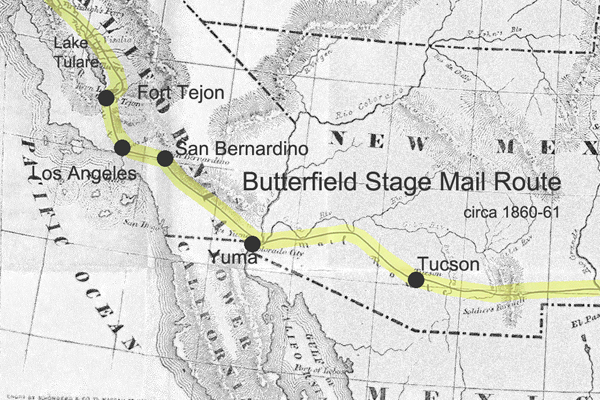
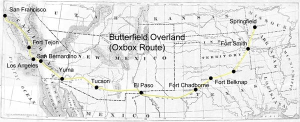
  1. Establishment: The Butterfield Overland Mail Company was awarded a government contract in 1857 to establish and operate a stagecoach and mail route between St. Louis, Missouri, and San Francisco, California. The purpose of the route was to improve communication and transportation between the two coasts, especially in light of the California Gold Rush.
  2. Route: The route covered approximately 2,800 miles and passed through eight present-day states: Missouri, Arkansas, Oklahoma, Texas, New Mexico, Arizona, California, and Oregon. It traversed various terrains, including deserts, mountains, and plains.
  3. Frequency and Duration: The Butterfield Overland Mail Company operated its stagecoaches twice a week in each direction, and the journey took about 25 days to complete. This significantly improved travel time compared to other methods available at the time.
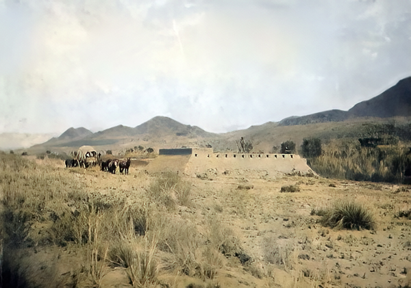
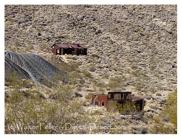
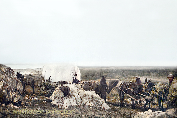
  4. Stations and Stops: The company established a series of stations along the route to facilitate the long and arduous journey, spaced about 20-30 miles apart. These stations provided fresh horses, food, and accommodations for passengers and drivers. Some of these stations eventually became important settlements in their own right.
  5. Challenges: The route faced numerous challenges, including harsh weather conditions, difficult terrain, and the threat of attacks from Native American tribes. The company had to implement security measures to protect passengers and mail.
  6. End of Operations: The Butterfield Overland Mail Route faced financial difficulties exacerbated by the onset of the Civil War. 1861, the service was suspended, and the stagecoaches and stations were abandoned. The route became less relevant as the transcontinental railroad was completed after the Civil War, offering faster and more reliable transportation.
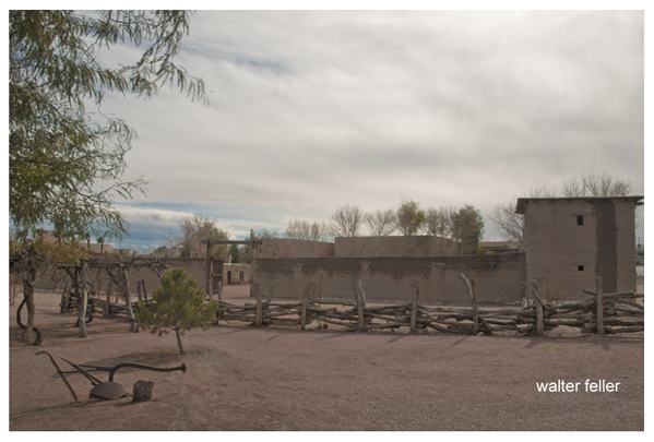
  7. Legacy: While the Butterfield Overland Mail Route was relatively short-lived, its legacy persists. The route contributed to the United States’s westward expansion and shaped the development of communities along its path. Some old stations have been preserved as historic sites, and portions of the route have been designated the “Butterfield Overland Mail Route.”

The Butterfield Overland Mail Route remains an important chapter in the history of westward expansion and transportation in the United States during the mid-19th century.

https://mojavedesert.net/stagecoaches/

https://mojavedesert.net/mojave-desert-indians/

https://digital-desert.com/historic-roads/

  1. Butterfield Overland Mail (or Oxbow Route):
    • The Butterfield Overland Mail was a stagecoach and mail delivery service that operated from 1857 to 1861. It was a vital communication and transportation link between the eastern and western United States.
    • The route covered approximately 2,800 miles, connecting St. Louis, Missouri, and San Francisco, California. It passed through several states, including Missouri, Arkansas, Texas, New Mexico, Arizona, and California.
    • The term “Oxbow” might not be directly associated with the Butterfield Overland Mail but could be a local or regional name for a section of the route or a specific location along the way.
  2. Overland Stage Route:
    • The Overland Stage Route, on the other hand, generally refers to the network of stagecoach routes that existed in the western United States during the 19th century. These routes were crucial for mail delivery, transportation of passengers, and freight.
    • The most famous of these stagecoach lines was the Butterfield Overland Mail, but there were other stage lines as well, such as the Central Overland California and Pikes Peak Express Company (C.O.C. & P.P.), which operated a route known as the “Pony Express.”

19th Century Military

https://mojavedesert.net/military/

Camp Cady – 1863, Rudolph D’Heureuse

The 19th century was a period of significant expansion and change in the United States, and the military played a crucial role in securing and maintaining control over newly acquired territories. The Mojave Desert was part of this expansion in the southwestern United States. Here are some key points about the military in the Mojave Desert during the 19th century:

  1. Mexican-American War (1846-1848): The Treaty of Guadalupe Hidalgo 1848 ended the Mexican-American War and ceded a large portion of territory, including the Mojave Desert, to the United States. The U.S. Army played a central role in the conquest and occupation of these new territories.
  2. California Gold Rush (1848-1855): The discovery of gold in California in 1848 led to a massive influx of settlers and prospectors. This increased population in the region and the military was tasked with maintaining order, protecting settlers from Native American resistance, and resolving conflicts among different groups.
  3. Mormon Pioneer Expeditions: In the mid-19th century, Mormon pioneers, led by Brigham Young, established a series of settlements in what is now Utah and the surrounding areas, including parts of the Mojave Desert. The military presence was important for maintaining peace and resolving disputes between the settlers and other groups.
  4. Butterfield Overland Mail Route: In the late 1850s, the Butterfield Overland Mail Company established a stagecoach route through the Mojave Desert, connecting the eastern and western coasts. The U.S. Army protected the mail coaches and stations along the route.
  5. Civil War (1861-1865): During the Civil War, many military forces were withdrawn from the western frontier to participate in the conflict. This temporarily reduced the military presence in the Mojave Desert. Additionally, the Confederate Army briefly invaded Arizona and New Mexico territories, which included parts of the Mojave Desert.
  6. Indian Wars: The 19th century saw conflicts between the U.S. military and various Native American tribes in the Mojave Desert region. The military was involved in efforts to control and relocate Native American populations.
  7. Fort Mojave: Established in 1859, Fort Mojave played a significant role in the military’s presence in the Mojave Desert. It served as a base for operations against local Native American tribes and protected settlers and travelers.
  8. Railroad Construction: The late 19th century also saw the construction of railroads through the Mojave Desert. The military played a role in ensuring the security of railroad workers and the transportation of goods.

Overall, the military presence in the Mojave Desert during the 19th century was shaped by the expansion of the United States, the Gold Rush, conflicts with Native American tribes, and the development of transportation routes across the region.

Randsburg Railway

https://mojavedesert.net/railroads/randsburg-railway/

Randsburg Railway refers to a historic narrow-gauge railway that once operated in and around the town of Randsburg, California, in the United States. Randsburg is a small mining town located in the Mojave Desert, and the railway played a significant role in the transportation of minerals and people in the late 19th and early 20th centuries.

The Randsburg Railway was primarily built to serve the mining industry, carrying gold, silver, and other valuable minerals from the mines in the area to nearby processing facilities. The railway also provided a means of transportation for the town’s residents and visitors.

The railway was initially constructed in 1896, connecting Randsburg with the Southern Pacific Railroad at Kramer Junction. The tracks covered about 12 miles and used narrow-gauge equipment. The Southern Pacific Railroad acquired the Randsburg Railway in 1897, and it became part of their system. This connection with the Southern Pacific allowed for the efficient transportation of ore and other goods to wider markets.

Over the years, the mining industry in Randsburg declined, and as a result, the railway’s importance diminished. The line was eventually abandoned in the mid-1930s. Today, Randsburg is a small, historic town that attracts tourists interested in its mining heritage and the remnants of the railway, which can still be seen in the area.

The Randsburg Railway is a part of the rich history of mining and transportation in the American West. It serves as a reminder of the challenges and opportunities that existed in the region during the late 19th and early 20th centuries.

Mormon Fort, Las Vegas, Nevada

https://digital-desert.com/mormon-fort/

The Mormon Fort in Las Vegas, Nevada, is a historic site that holds significance in the region’s history. It is also known as the Old Mormon Fort State Historic Park. The fort represents the birthplace of Las Vegas and is considered the first permanent, non-native settlement in the Las Vegas Valley.

Here are some key points about the Mormon Fort:

  1. Establishment: The fort was established by a group of Mormon missionaries led by William Bringhurst in 1855. They were sent to the area to establish a way station along the Old Spanish Trail.
  2. Purpose: The Mormons built the fort to provide a place for travelers and settlers to rest and replenish supplies as they journeyed through the region. It served as a crucial stop for those traveling between Salt Lake City and Southern California.
  3. Abandonment: Due to conflicts with local Native American tribes and other challenges, the Mormons abandoned the fort in 1857.
  4. Later History: The fort had various uses over the years, including serving as a ranch and a military post. In the early 20th century, efforts were made to preserve and restore the site.
  5. State Historic Park: Today, the Old Mormon Fort is a state historic park managed by the Nevada Division of State Parks. It offers visitors a glimpse into the area’s past, featuring reconstructed adobe buildings and interpretive exhibits.
  6. Location: The Mormon Fort is located in downtown Las Vegas, near the intersection of Las Vegas Boulevard and Washington Avenue.

Visitors to the Mormon Fort can explore the historic structures, learn about the early pioneers who settled in the area, and gain insights into the challenges faced by the original inhabitants. The site provides a contrast to the modern development of Las Vegas and highlights its historical roots.

Roads West

Mojave Road and Beale’s Wagon Road are historic routes in the southwestern United States, particularly in the Mojave Desert region. Here’s some information about each:

  1. Mojave Road:
    • The Mojave Road is a historic trail that traverses California’s Mojave Desert. It was a significant route used by Native Americans, Spanish missionaries, and later by American pioneers and traders.
    • The trail is approximately 138 miles long and extends from the Colorado River near present-day Needles, California, to the Mojave River near present-day Barstow, California.
    • It was primarily used for transportation and trade between the Colorado River and the coastal settlements in California. The trail passes through varied desert landscapes, including sandy stretches, rocky terrain, and mountainous areas.
  2. Beale’s Wagon Road:
    • Beale’s Wagon Road, named after Edward F. Beale, a military officer and explorer, was a trail developed in the 19th century for the U.S. Army to improve communication and transportation across the arid lands of the American Southwest.
    • Edward F. Beale surveyed and established the road in the late 1850s. The road ran from Fort Defiance in Arizona to the Colorado River, passing through present-day Arizona and California.
    • Beale’s Wagon Road was designed to be more reliable and accessible than other trails, facilitating military movement and communication between California and the western territories.

Mojave Road and Beale’s Wagon Road were important in the United States’ westward expansion. Today, these routes attract history enthusiasts, adventurers, and off-road enthusiasts who explore them to experience the challenges faced by those who traveled these paths in the past. Keep in mind that conditions and accessibility of these trails may vary, so it’s important to check for current information and any regulations before embarking on a journey along these historic routes.

Scotty

“Death Valley” Scotty, whose full name was Walter E. Scott, was a colorful and legendary figure associated with Death Valley, a desert valley located in Eastern California. Scotty gained fame in the early 20th century for his claims of owning a gold mine in Death Valley and for his flamboyant personality.

Scotty’s story is closely tied to his relationship with wealthy Chicago businessman Albert Johnson. In the early 1900s, Scotty convinced Johnson to invest in his supposed gold mine, even though there was little evidence to support the existence of significant gold deposits. Despite the skepticism of others, Johnson continued to finance Scotty’s ventures, and the two became unlikely friends.

With his charismatic and theatrical personality, Scotty became a well-known character, and his antics and stories helped attract attention to Death Valley. He was known for his cowboy attire, tall tales, and his ability to charm people.

Scotty’s gold mine claims were largely exaggerated, and there is little evidence that he ever discovered a significant amount of gold. The financial arrangement between Scotty and Johnson remained a subject of speculation and mystery.

After Johnson died in 1948, it was revealed that much of the financing had come from Johnson himself, and Scotty had not been as successful in the mining business as he claimed. Despite the deceptive aspects of his story, Scotty remained a beloved figure in Death Valley folklore, and his former home, Scotty’s Castle, is a popular tourist attraction in Death Valley National Park.

The legacy of “Death Valley” Scotty is a mix of fact and fiction, blending the mystique of the Old West with a touch of showmanship and exaggeration.

Boomtown Historical Context and Characteristics

Rush to Claim Wealth: The news of these discoveries led to a rush of people trying to claim their share of the newfound wealth. Prospectors and miners flocked to the region in search of fortunes.

Randsburg c. 1897 – C.W. Tucker – photo

Discovery of Gold and Silver: These booms were triggered by the chance discovery of large deposits of gold and silver in the respective areas. The presence of valuable minerals was the catalyst for the rapid development of these towns.

Leadfield (2003)

Explosive Growth of Boomtowns: The growth of these towns was explosive and often chaotic. They quickly developed into rowdy boomtowns characterized by a fast-paced, often disorderly expansion.

Promoters and Flimflam Men: Alongside serious promoters who saw the economic potential of these towns, there were also flashy con artists and tricksters looking to take advantage of the mining boom for their gain.

Arrival of Various Groups: As these towns grew, they attracted a diverse group of people, including merchants, teamsters, camp followers, schoolteachers, wives, and children. The influx of residents and services accompanied the rapid development.

Development of Farms and Ranches: The growth of these mining towns also led to the development of nearby farms and ranches. These agricultural activities provided food and resources to sustain the booming population.

Hope for Quick Riches: Many who flocked to these mining towns were motivated by the hope of striking it rich quickly. The prospect of finding valuable minerals and becoming wealthy was a powerful draw.

Values of the Old West: The people who settled in these towns held traditional values associated with the Old West, including a strong emphasis on personal freedom, independence, hard work, and the ability to endure the harsh conditions and challenges of the natural environment.

Cook Bank – Rhyolite, Nevada

Like many others in the Old West, these mining booms followed a pattern of rapid growth, economic opportunity, and social change, often accompanied by a degree of lawlessness and volatility. Over time, these towns could thrive or decline depending on the success of mining operations and economic factors, and their histories reflect the larger story of the American frontier and the pursuit of wealth and opportunity.

Mojave Road

/mojave-road/

Soda Springs – 1863

The Mojave Road, also known as the Old Mojave Road or the Mojave Trail, is a historic trade route and wagon road that traverses the Mojave Desert in the southwestern United States. Native American tribes originally used it for trade, and it later became an important transportation route for European settlers and traders during the 19th century.

Here are some key points about the Mojave Road:

Location: The Mojave Road runs through the Mojave Desert, primarily in what is now California and Nevada. It stretches from the Colorado River in the east to the San Bernardino Mountains in the west, covering approximately 140 miles (225 kilometers).

History: The road has a long history, with Native American tribes using it for centuries for trade and travel. In the 19th century, it became an essential route for early explorers, settlers, and traders moving through the desert.

Water Sources: One of the challenges of traveling the Mojave Road was the scarcity of water sources. Travelers had to rely on natural springs and wells, many of which were marked along the route to aid navigation.

Military Use: During the 19th century, the U.S. Army used the Mojave Road as a military supply route and for communication between the southern California coast and the interior of the Southwest. The road played a role in the U.S. government’s efforts to control the region.

Historic Sites: Along the Mojave Road, there are several historic sites and landmarks, including the Mojave National Preserve, the Mojave River, the Kelso Depot, and the Fort Piute ruins.

Recreation: Today, the Mojave Road is a popular route for off-road enthusiasts, hikers, and history buffs. Travelers can explore the historic route and experience the natural beauty of the Mojave Desert.

Preservation: Efforts have been made to preserve and maintain the Mojave Road as a historic and recreational route. The Mojave Road Guide, written by historian Dennis G. Casebier, is a valuable resource for those interested in traveling the road.

Please note that road conditions and accessibility may vary, so if you plan to explore the Mojave Road, it’s essential to do thorough research and be well-prepared for the journey. Always check for current information and obtain any necessary permits if required.

Leadfield – Summary

https://mojavedesert.net/mining-history/leadfield/index.html

Leadfield, located in Titus Canyon, was promoted by a man who could have sold ice to an Eskimo. He blasted some tunnels and liberally salted them with lead ore and drew up some enticing maps of the area, which lured Eastern promoters into investing money.

The true story of Leadfield is somewhat different from the usual tale of a stock swindle and a dying town.

During the early days of the Bullfrog boom, W. H. Seaman and Curtis Durnford staked nine lead and copper claims in Titus Canyon and came into Rhyolite with ore samples that assayed as high as $40 to the ton. The Death Valley Consolidated Mining Company was incorporated and immediately began a development and promotional campaign.

The Death Valley Consolidated Mining Company ceased operations in 1906 after realizing that the long and arduous trip between its mine and Rhyolite made the shipment of its ore absolutely unprofitable.

In 1924, three prospectors staked out numerous claims on some lead deposits in Titus Canyon. A local promoter named John Salsberry purchased twelve claims from the three prospectors and formed the Western Lead Mines Company.

The young camp was entering the boom stage, and by January 30th, half a dozen mining companies were in operation. The stock of Western Lead Mines Company soared to $1.57 per share.

Eastern California, and especially Inyo County, was long overdue for a mining boom. With the backing of a successful and skilled promoter, Leadfield seemed assured of obtaining the necessary financial support to take it from a prospecting boom camp into a producing mine town.

The Inyo Independent greeted Julian with a glowing description of his character and abilities, but a different endorsement would be printed in later years.

The boom was now on in earnest, with the Western Lead Company employing 140 men and the Titus Canyon Road being completed. The Western Lead Mine produced 8% to 30% lead and seven ounces of silver per ton.

The California State Corporation Commission was not so impressed with the company and raised the righteous indignation of local folk. The local attitude was well summed up by the Owens Valley Herald: “The Commission is using its every endeavor to try and prejudice the people against this latest promotion of Julian’s.”

The paper pointed out that Julian was not trying to swindle anyone and that he had publicly invited any reputable mining engineer worldwide to visit the Leadfield District. The paper concluded that the future of Leadfield seemed very bright.

Julian was not the only promoter singing the praises of the Leadfield District, for numerous other companies were also trying to cash in on the boom. The Western Lead Mines Company, Julian’s pet, led the pack, with one of its tunnels six hundred feet inside the mountain.

The town of Leadfield was trying to keep pace with the boom and announced that a large hotel would soon be built. On March 15th, the first of Julian’s promotional excursions pulled into Beatty, and 340 passengers were served a sumptuous outdoor feast by the proprietor of the local Ole’s Inn.

Lieutenant-Governor Gover of Nevada gave the keynote speech, and Julian gave a speech praising Julian for overcoming the numerous obstacles that modern governmental bureaucracies put in a man’s path. The trip was a big success, and Western Lead stock advanced 25 on the San Francisco market the next day.

Western Lead stock had soared to $3.30 a share by the end of March, and several ore-buying and smelting concerns sent representatives to the district to discuss reduction and smelting rates.

Leadfield continued to develop in the months following the great train excursion. New mining companies opened for business, and the Tonopah & Tidewater Railroad replied that definite plans for a railroad spur into Leadfield had not been made as the present business does not warrant its construction.

The townsite of Leadfield was officially surveyed on April 30th, and the town’s plat was submitted to Inyo County officials for approval. The town was platted on land donated by the Western Lead Company.

The State of California was breathing hard upon Julian’s neck, and the Corporation Commission hauled a brokerage company into court for selling Western Lead stock without a state permit. Expert witnesses testified that the Western Lead Mine was a quite legitimate proposition.

The continued investigations by the state of California hurt the sales of Western Lead stock, and another factor began to take a toll. Julian’s credibility began to shrink, and the company never recovered from the panic that set in.

Julian bought into the New Roads Mining Company, which gave him control of the two largest mines of Leadfield and announced plans to construct a large milling plant at Leadfield.

As summer approached, the Leadfield boom showed no signs of peaking. The California Corporation Commission ordered that sales of Julian’s personal stock in the Western Lead Mines must immediately cease on the Los Angeles stock exchange due to evidence introduced at a hearing.

Despite the heavy blow to Julian’s financial fortunes, developments at Leadfield proceeded, and the Mining Journal printed a long, detailed report on the Leadfield District in July, which helped to restore public confidence.

The mines agreed with the independent experts and continued to work, and the Boundary Cone Mining Company ordered a new 25-horsepower hoist and headframe and increased its workforce to twelve miners.

In late July, the Western Lead Mining Company brought a $350,000 damage suit against the Los Angeles Times and the California Corporation Commission. Still, the suit was quickly thrown out of court for insufficient cause. In August, a new mining company, the Pacific Lead Mines No. 2, was incorporated.

During September and October, drilling and tunneling continued in Leadfield’s mines, but in late October, two events took place that spelled the end of Leadfield. The main tunnel of the Western Lead Mine finally penetrated the ledge but found almost nothing.

At almost the same time, the California Corporation Commission dealt Julian another blow when it halted stock sales in the Julian Merger Mines, Inc. Julian’s empire fell apart. The other mines slowly closed, one after the other, and Leadfield became a ghost town in a matter of months.

The failure of a mining district led to a flurry of lawsuits. In February of 1927, the Western Lead Company removed its heavy machinery and the pipeline to a mine that the company owned in Arizona.

Julian went on to organize the Julian Oil and Royalties Company and was indicted for fraud, but jumped bail and committed suicide.

Leadfield was a ghost town created by C. C. Julian. Still, the existence of lead ore in the district had been known as far back as the Bullfrog boom days of 1905, and the California Corporation Commission allowed companies other than Julian’s to sell their stock.

Julian did not start the Leadfield boom and had plenty of help in supporting the boom once it had started. The citizens of Inyo County, California, and Nye County, Nevada, also supported the mines.

The collapse of Julian’s financial structure came at the worst possible time for Leadfield. Although it seems doubtful that Leadfield had enough ore to support more than a small mining company or two, indications are that without the sudden panic of the fall of 1926, that mine or two could have survived.

The Titus Canyon Road, an engineering marvel, was built by Julian and cost an estimated $60,000 to build. Without Julian, the road would not have been finished, and today presents one of the most spectacular routes in Death Valley National Park.

ONE TUNNEL . . . ONE LIFETIME

By Paul Hubbard, Randsburg Times    

High in the El Paso Range, in the upper reaches of Mesquite Canyon, twelve miles west of Randsburg, in the living exponent of persistence, William Schmidt, better known to desert folks in that area as “Burro” Schmidt, 80-year-old recluse, “Burro” spent forty years of his life accomplishing one thing—hand-drilling a half-mile tunnel entirely through a mountain.

 Over that period, he worked on farms in the Kern River Valley, accumulating “beans” for the winter at his mine. Regularly, he appeared in Johannesburg with his burros and loaded up supplies at the Teagle’s Store each fall. 1937, his tunnel was finished, and the accomplishment received national publicity. Photographs of the tunnel, his burrow, and “Burro” Schmidt appeared in daily press and international mining journals. Single jack and drill steel and “Burro” Schmidt were the combination that did the job — no compressed air or gasoline motors.

As he nears the end of the trail, happy to have completed a lifetime undertaking, he proposes offering his tunnel and the story of mineralogy it tells to a California university. It will be a natural laboratory for the new generations who want to know the story of the rocks. It is a noble gesture from a nobleman of the desert hills.

https://digital-desert.com/burro-schmidt-tunnel/

https://digital-desert.com/burro-schmidt-cabin/

https://mojavedesert.net/people/schmidt.html

https://digital-desert.com/burro-schmidt-cabin/memorial.html