#8 – Amboy Crater: A Volcanic Landmark in the Mojave Desert

/amboy-crater/

Amboy Crater – Outside looking in.

Amboy Crater is a remarkable natural feature in the Mojave Desert, offering visitors a unique opportunity to explore a dormant volcanic cinder cone and its surrounding landscape. Here’s an expanded look at what makes Amboy Crater a popular attraction:

Geological Significance

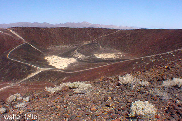
  • Formation: Amboy Crater is a cinder cone volcano that formed during an eruption approximately 79,000 years ago. The eruption produced the cone and extensive lava fields that stretch across the desert floor.
  • Volcanic Structure: The crater stands about 250 feet above the surrounding landscape and has a diameter of about 1,500 feet—the crater’s interior features a flat floor and a breached rim, indicative of past volcanic activity.

Attractions and Activities

  1. Hiking to the Crater:
    • Trail Information: The hike to the summit of Amboy Crater is a moderately challenging trek of about 3 miles round trip. The trailhead is equipped with interpretive signs that provide information about the volcanic history and the local ecology.
    • Trail Experience: The trail leads through lava fields and desert terrain, offering a chance to see various volcanic features up close. The ascent to the crater rim provides stunning views of the surrounding desert.
  2. Exploring the Crater:
    • Crater Interior: Once at the top, hikers can descend into the crater’s interior, which features a flat floor covered with volcanic ash and small rocks. It’s a unique landscape that feels almost otherworldly.
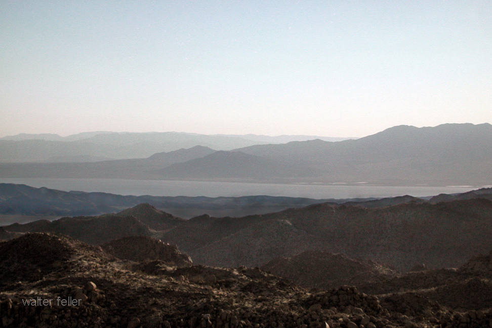
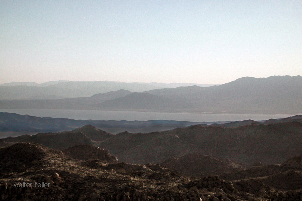
    • Scenic Views: The crater’s rim offers panoramic views of the Mojave Desert, including the vast lava fields and distant mountain ranges. The view is particularly striking at sunrise and sunset.
  3. Wildlife and Flora:
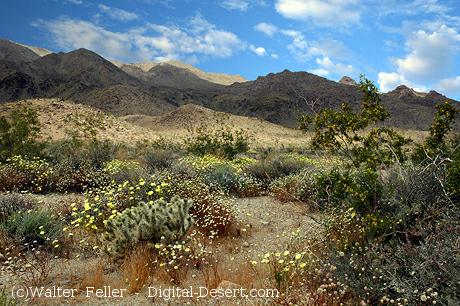
    • Desert Plants: The area around Amboy Crater is home to various desert plants, including creosote bushes, cacti, and wildflowers. During spring, the landscape can be dotted with colorful blooms.
    • Wildlife: Visitors might spot desert wildlife like lizards, snakes, and birds. Despite the harsh conditions, the area’s natural habitat supports a diverse ecosystem.
  4. Photography Opportunities:
    • Landscape Photography: The stark contrast between the black lava fields and the sandy desert creates dramatic photo opportunities. The crater’s unique geological features make it a favorite subject for photographers.
    • Astrophotography: Amboy Crater’s remote location and lack of light pollution make It an excellent spot for stargazing and astrophotography. The clear desert skies provide breathtaking views of the night sky.

Visitor Information

  • Location and Access: Amboy Crater is located off historic Route 66, near the town of Amboy. The site is accessible via a well-maintained dirt road and a parking area at the trailhead.
  • Facilities: The trailhead features shaded picnic tables, informational kiosks, and restroom facilities. There is also a viewing platform for those who prefer not to hike but still want to enjoy the scenery.

Historical and Cultural Context

  • Route 66: Amboy Crater is situated along the iconic Route 66, adding a layer of historical significance. The nearby town of Amboy and the famous Roy’s Motel and Café provide a nostalgic glimpse into the heyday of America’s Mother Road.
  • Cultural Significance: The crater and its surroundings have been a significant landmark for indigenous peoples, early travelers, and modern explorers. It has been a navigation point and a source of fascination for centuries.

Safety and Preparation

  • Hiking Precautions: Due to the harsh desert environment, hikers should come prepared with plenty of water, sun protection, and appropriate footwear. The trail can be challenging, especially in hot weather.
  • Weather Considerations: The best times to visit are during the cooler months of fall, winter, and early spring. Summer temperatures can be extreme, making hiking hazardous.

Conservation Efforts

  • Protected Area: Amboy Crater is designated a National Natural Landmark, recognizing its geological significance and ensuring its protection for future generations.
  • Responsible Tourism: Visitors are encouraged to practice Leave No Trace principles, respecting the delicate desert environment and preserving the area’s natural beauty.

Amboy Crater offers a unique blend of geological wonder, natural beauty, and historical intrigue. Whether you’re an avid hiker, a photography enthusiast, or simply curious about the natural world, Amboy Crater provides a memorable and enriching experience in the heart of the Mojave Desert.

Pinto Basin and Mountains

The Pinto Basin and Mountains, located in Joshua Tree National Park in southern California, are notable for their rugged terrain, diverse geology, and rich history. Here’s an overview of the key aspects of this region:

Geography and Geology

Pinto Basin

  • Location: The Pinto Basin is in the southeastern part of Joshua Tree National Park.
  • Terrain: The basin is characterized by broad, sandy expanses interspersed with rocky outcrops and occasional washes.
  • Geology: The basin’s geology is diverse, with ancient Precambrian rocks, including gneiss and schist, and recent sedimentary deposits. The basin’s alluvial fans are made of materials eroded from the surrounding mountains.

Pinto Mountains

  • Location: The Pinto Mountains lie to the south of the Pinto Basin.
  • Elevation: The mountains vary in elevation, with some peaks rising over 3,000 feet above sea level.
  • Geology: The mountain range comprises various rock types, including granitic and metamorphic rocks, indicative of a complex geological history involving volcanic activity and tectonic movements.

History

Prehistoric and Native American Presence

  • Pinto Culture: The region is named after the Pinto Culture, an early Native American group that inhabited the area around 8,000 to 10,000 years ago. Artifacts such as stone tools and points have been found, suggesting a hunter-gatherer lifestyle.
  • Native American Tribes: Various tribes, including the Chemehuevi and Cahuilla, lived in the region, relying on its resources for sustenance.

Historic Era

  • Mining: In the late 19th and early 20th centuries, the Pinto Basin and Mountains saw sporadic mining activity, primarily for gold and other minerals. Remnants of old mines and mining equipment can still be found in the area.
  • Homesteading: In the early 20th century, homesteaders attempted to settle in the region, though the harsh desert environment made it challenging.

Flora and Fauna

  • Flora: The Pinto Basin is home to various desert plant species, including creosote bush, Joshua trees, and ocotillo. The area’s unique ecosystem supports common and rare plant species adapted to the arid conditions.
  • Fauna: The Pinto Basin’s wildlife includes desert bighorn sheep, coyotes, jackrabbits, and numerous bird species. Reptiles such as lizards and snakes inhabit the area.

Recreation and Attractions

  • Hiking: The Pinto Basin offers several hiking opportunities, with trails ranging from easy walks to challenging backcountry routes. Popular trails include the Lost Palms Oasis and the Arch Rock Nature Trail.
  • Scenic Drives: The Pinto Basin Road provides a scenic drive through the basin, offering stunning landscape views and access to various trailheads and viewpoints.
  • Stargazing: The remote location and minimal light pollution make the Pinto Basin an excellent spot for stargazing and astrophotography.

The Pinto Basin and Mountains are a fascinating area within Joshua Tree National Park, offering visitors a glimpse into the natural and cultural history of the Mojave Desert.

/ecosections/322ap.htm

History of the Salton Sea

Salton Sea view from Mastodon Peak

The Salton Sea, located in the Colorado Desert of Southern California, is a fascinating and complex body of water with a rich history shaped by both natural and human influences. Here’s an overview of its history:

Prehistoric and Early History

  1. Ancient Lake Cahuilla:
    • The Salton Sea’s basin has intermittently held water for thousands of years. The area was once part of Lake Cahuilla, a massive freshwater lake that existed during prehistoric times and was periodically filled by the Colorado River.
    • Native American tribes, such as the Cahuilla and Kumeyaay, lived around the lake and utilized its resources.

Formation of the Modern Salton Sea

  1. 1905-1907: Creation:
    • The modern Salton Sea was created by accident in 1905 when engineers working on irrigation canals for the Imperial Valley inadvertently diverted the entire flow of the Colorado River into the Salton Sink.
    • For nearly two years, the river flowed unchecked into the basin, filling it and creating the Salton Sea.

20th Century Development

  1. Agricultural Hub:
    • The region around the Salton Sea became a vital agricultural area due to the fertile soil and irrigation from the Colorado River.
    • Runoff from these agricultural activities has been a major source of water for the Sea.
  2. Mid-20th Century: Recreation Boom:
    • In the 1950s and 1960s, the Salton Sea became a popular recreational destination, often referred to as a “miracle in the desert.”
    • Resorts, marinas, and yacht clubs flourished, attracting celebrities and tourists for boating, fishing, and other water activities.

Environmental Challenges

  1. Rising Salinity and Pollution:
    • Over time, the Salton Sea’s salinity increased due to evaporation and lack of freshwater inflow: agricultural runoff containing fertilizers and pesticides further degraded water quality.
    • The increasing salinity began to harm fish populations, leading to mass die-offs and the collapse of the once-thriving fishing industry.
  2. Health and Environmental Concerns:
    • The drying of the Salton Sea has exposed toxic dust from the lakebed, posing health risks to surrounding communities.
    • The ecosystem has been severely impacted, with significant losses of fish and bird populations that once thrived in the area.

Modern Efforts and Challenges

  1. Restoration Efforts:
    • Numerous efforts have been proposed and some initiated to address the Salton Sea’s environmental issues. These include water management projects, habitat restoration, and dust suppression measures.
    • California state agencies and environmental groups continue to work on strategies to mitigate the ecological and health impacts.
  2. Ongoing Challenges:
    • Despite these efforts, the Salton Sea remains a critical environmental challenge. Balancing agricultural needs, wildlife conservation, and public health concerns continues to be a complex and contentious issue.

The history of the Salton Sea is a testament to the intricate interplay between human activities and natural processes. It serves as a poignant reminder of the consequences of environmental mismanagement and the ongoing need for sustainable solutions.

The Needles, Mohave Mountains, Arizona

The Needles in the Mohave Mountains of Arizona present a unique geological character.

Here’s an overview of the geology of this area:

Location and Formation

The Chemehuevi Mountains are located in southeastern California and extend into the Mohave Mountains in Arizona. This range is part of the Basin and Range Province and is characterized by its dramatic elongated mountain ranges separated by flat valleys or basins.

Erosional Features

The Needles within the Mohave Mountains are likely a result of extensive erosional processes that have sculpted the landscape over millions of years. Weathering and erosion, driven by temperature fluctuations, water action, and wind, have exposed the harder, more resistant rock formations. These processes create the sharp, needle-like spires and rugged terrain typical of the area.

Ecological and Environmental Significance

The Mohave Mountains’ geological diversity supports various habitats and is significant for biodiversity. The area’s unique geology affects soil composition, water availability, and vegetation types, all of which contribute to the ecological complexity of the region.

These geological and erosional processes have given the Mohave Mountains their distinctive rugged appearance, making them a notable example of the dynamic Earth processes at work in the desert environments of the American Southwest.

Cat Dune – Hanging Dune


A “hanging dune” is a specific type of sand dune that forms on the leeward side of a hill or mountain, typically above the general level of the surrounding terrain. These dunes are essentially perched above other landforms, often appearing as though they are hanging on the slopes.

Here’s how they develop and some characteristics:

Formation

Hanging dunes primarily form in areas with significant wind activity where the topography causes the wind to deposit sand on steep slopes rather than just along flat surfaces. This process involves:

  • Wind Patterns: Strong, consistent winds carry sand from lower areas.
  • Obstacle Impact: When these winds encounter steep slopes or cliffs, their upward deflection causes a reduction in wind speed, dropping the sand and forming a dune.
  • Accumulation: Over time, more sand accumulates, stabilizing despite the steep slopes due to vegetation or moisture, further building the dune.

Characteristics

  • Location: They are typically found on the sides of hills, cliffs, or within mountain ranges where wind patterns are disrupted by the topography.
  • Stability: These dunes can be quite stable if vegetation anchors the sand, or they can be transient and shift with changes in wind patterns.
  • Ecological Impact: Hanging dunes can create unique microenvironments that support specialized plants and animals adapted to these specific conditions.

Geologic and Ecological Significance

  • Indicator of Wind History: The presence and orientation of hanging dunes can provide clues about historical wind directions and strengths.
  • Biodiversity: These dunes can host unique species that have adapted to the niche environments created by the unusual moisture and temperature conditions on the slopes.
  • Conservation: Due to their unique nature and the specialized ecosystems they support, hanging dunes can be important areas for ecological studies and conservation efforts.

Hanging dunes are less common than other dune types and require a unique set of environmental conditions to form and persist, making them particularly interesting for geologists and ecologists studying aeolian (wind-driven) processes and desert ecosystems.

The Mojave River Fan

https://digital-desert.com/natural-mojave-river/basin.html

https://digital-desert.com/mojave-river/geology.html

https://digital-desert.com/mojave-river/index.html

The Mojave River Fan, located in the Mojave Desert of California, is an extensive alluvial fan formed by the deposition of sediments from the Mojave River. This geological formation is significant due to its role in shaping the landscape and hydrology of the region. Here are some key aspects of its geology:

  1. Formation and Composition:
    • The fan comprises sediments such as sand, gravel, and finer materials from the surrounding mountains carried down by the Mojave River and its tributaries. These sediments are deposited primarily during periods of high water flow, typically associated with rainfall events.
    • The materials are sorted by size, with coarser materials settling closer to the mountains and finer materials spreading further onto the fan.
  2. Geological Features:
    • The Mojave River Fan is characterized by its radial pattern, spreading from where the river emerges from the mountains onto the flatter desert plain. This spreading creates a broad, gently sloping surface.
    • The fan is divided into different lobes or segments, each representing periods of active deposition under varying climatic and hydrologic conditions.
  3. Hydrology and Erosion:
    • The fan plays a critical role in the desert’s hydrology, influencing groundwater recharge and the distribution of aquifers. Water percolates through the porous sediments, replenishing groundwater reserves.
    • Erosional processes also shape the fan, as water channels carve out new paths during floods, redistributing the sediments.
  4. Environmental and Climatic Influences:
    • The formation and evolution of the fan are closely linked to climatic changes over geological time scales. Periods of wetter climate have led to increased sediment load and fan expansion, while drier periods have seen reduced activity.
  5. Human Impact and Studies:
    • The area has been the subject of various geological and environmental studies, especially concerning water resource management and hazard assessment due to its proximity to populated areas and infrastructure.

Understanding the geology of the Mojave River Fan is crucial for managing natural resources and mitigating natural hazards in this part of the Mojave Desert.

Sierra Nevada Batholith

The Sierra Nevada Batholith is a large, composite body of igneous rock in the Sierra Nevada range of California. This batholith, mainly composed of granitic rock, was formed during the Mesozoic era, particularly from the Late Jurassic to the Late Cretaceous period. It extends over a vast area and is exposed over approximately 400 miles along the western slopes of the Sierra Nevada.

Sierra Nevada Batholith

The formation of the Sierra Nevada Batholith is tied to the subduction of the oceanic Farallon Plate beneath the North American Plate. As the plate subducted, it generated magmas that rose and solidified to form the granite that characterizes this batholith. The emplacement and cooling of these granitic magmas over millions of years have significantly influenced the region’s geology and topography.

Geologically significant and visually striking, the Sierra Nevada Batholith is a major feature underlying the rugged landscapes of Yosemite Valley and other parts of the Sierra Nevada. It is important not only for shaping the physical landscape but also for contributing to understanding the geological processes of mountain building and magmatic intrusions.

The information about the Sierra Nevada Batholith is based on well-established geological knowledge and does not come from a specific source.

For in-depth information about the Sierra Nevada Batholith, the following sources are highly recommended:

  1. “Geology of the Sierra Nevada” by Mary Hill – This book provides a comprehensive overview of the geological history of the Sierra Nevada, including detailed discussions on the formation of the Sierra Nevada Batholith.
  2. “Roadside Geology of Northern and Central California” by David Alt and Donald W. Hyndman – This guidebook includes accessible explanations and descriptions of geological features along various routes, including those that expose parts of the Sierra Nevada Batholith.
  3. “The Geologic Story of Yosemite National Park” by N. King Huber—While focused on Yosemite, this publication offers valuable insights into the granitic formations making up the Sierra Nevada Batholith and their significance in the park’s natural history.
  4. Scholarly articles such as the Journal of Geophysical Research or Geological Society of America Bulletin often publish research on the Sierra Nevada Batholith, discussing its formation, composition, and role in regional geology.

These sources will provide a detailed and accurate understanding of the Sierra Nevada Batholith, suitable for educational and research purposes.

Lake Manix

/lake-manix/

Pleistocene Ancient Mojave River System

Lake Manix is an ancient lake in what is now the Mojave Desert of California, USA. It was part of the ancient Mojave River system, which flowed through the area during periods of the Pleistocene epoch when the climate was wetter than it is today. The presence of this lake is a testament to the dramatically different environmental conditions that prevailed in the region thousands of years ago.

Lake Manix

In its ancient course, the Mojave River fed into Lake Manix, creating a significant water body supporting diverse flora and fauna. This ancient river system was vital for migrating and sustaining animals and possibly early human populations. Over time, Lake Manix eventually dried as the climate became warmer, and the Mojave River’s flow diminished significantly. The remnants of this ancient river system can still be traced in the modern landscape of the Mojave Desert, with the Mojave River now flowing intermittently and largely underground.

Archaeological and geological evidence from the Lake Manix area provides valuable insights into the climatic changes that have occurred over millennia in the Mojave Desert. Studies of sediment deposits, fossil records, and other geological features around the former lake site help scientists reconstruct the paleoenvironmental conditions, offering clues about water availability, vegetation types, and the animals that once inhabited the region.

The transition from a wetter, lake-dominant landscape to the arid desert environment of today highlights the dynamic nature of Earth’s climate and ecosystems. Understanding the history of Lake Manix and the ancient Mojave River system contributes to our knowledge of past climatic shifts. It helps inform current and future conservation efforts in desert ecosystems.

Coyote Arm of Lake Manix

The Coyote arm of Lake Manix refers to a specific portion or segment of ancient Lake Manix, which existed during the Pleistocene epoch in what is now the Mojave Desert of California. This area is particularly interesting to geologists and archaeologists because it provides evidence of the extent of the lake and the environmental conditions that prevailed in the region.

Lake Manix covered a large area and had multiple “arms” or extensions, with the Coyote arm being one of them. These arms were parts of the lake that extended into different valleys or low-lying areas, filled by the ancient Mojave River and its tributaries. The existence of these arms indicates that the lake’s water levels and boundaries changed over time, influenced by climatic fluctuations, precipitation patterns, and river flow dynamics.

Studying the Coyote arm and other parts of Lake Manix helps scientists reconstruct the paleohydrology of the region. By examining sediment layers, fossil remains, and other geological features, researchers can infer past water levels, the timing of lake expansion and contraction, and the habitats around the lake. This information is crucial for understanding how ancient ecosystems responded to climate change and how they supported early human populations and other species.

Evidence from the Coyote arm and similar areas around the former Lake Manix also contributes to our understanding of the broader paleoclimatic patterns in North America. Such studies are part of a larger effort to piece together the history of Earth’s climate and how it has shaped the development of landscapes and ecosystems over geological time scales.

Troy Lake arm of Lake Manix

The Troy Lake arm of Lake Manix represents another significant segment of the ancient Lake Manix, which was a part of the extensive Pleistocene-age lake system in the Mojave Desert, California. Like the Coyote arm, the Troy Lake arm was one of the various extensions or branches of Lake Manix, fed by the ancient Mojave River and its tributaries during a time when the climate was considerably wetter than it is today.

The presence of the Troy Lake arm and other arms like the Coyote arm indicate the region’s complex hydrology and varied topography during the Pleistocene. These arms were essentially the lake’s extensions into surrounding valleys, creating diverse habitats for various plant and animal life. These lake arms’ fluctuating boundaries and water levels, driven by climatic variations, offer valuable insights into past environmental conditions.

Researchers study the Troy Lake arm and focus on sediment deposits, fossilized remains, and other geological indicators to understand the lake’s hydrology, such as water depth, extent, and changes over time. These studies contribute to a broader understanding of how ancient lake systems like Lake Manix responded to glacial and interglacial cycles, influencing precipitation patterns, temperature, and, ultimately, the region’s hydrography.

The research on the Troy Lake arm, alongside other parts of Lake Manix, is crucial for reconstructing past climates and ecosystems. It helps in understanding the challenges faced by early human settlers and the strategies they employed for survival. Moreover, it provides context for current environmental changes and aids in predicting future climatic shifts, especially in desert regions like the Mojave, which are sensitive indicators of broader environmental transformations.

Afton Canyon

/afton-canyon/

Afton Canyon, often called the “Grand Canyon of the Mojave,” is a striking geological feature in California’s Mojave Desert. It is renowned for its dramatic landscape, including steep canyon walls, rare desert waterways, and various wildlife. The formation of Afton Canyon is closely tied to the history of Lake Manix and the ancient Mojave River system.

During the Pleistocene epoch, when Lake Manix existed, it was a significant water body fed by the Mojave River, which carried meltwater from glaciers in the mountains to the north. Over time, the climate became drier, and the lake levels fluctuated. Eventually, Lake Manix breached its natural dam, leading to a catastrophic water outflow. This event was a pivotal moment in the formation of Afton Canyon.

The breach of Lake Manix’s dam caused a massive release of water that carved through the landscape, creating Afton Canyon. Rapid erosion cut deeply into the sediment and rock, forming the canyon’s distinctive steep walls. The force of the water was so powerful that it removed vast amounts of material, shaping the canyon into its present form.

Today, Afton Canyon remains one of the few places in the Mojave Desert where the Mojave River flows above ground, offering a rare glimpse into the water’s erosive power that shaped the landscape. The canyon’s formation is a testament to the dynamic geological processes that have occurred over millennia, driven by climatic shifts and water movement.

The role of Lake Manix in forming Afton Canyon highlights the interconnectedness of geological features within the Mojave Desert. It illustrates how ancient lakes, rivers, and climatic conditions have sculpted the region’s unique landscapes. Afton Canyon’s creation is a prime example of how water, even in arid environments, can be a powerful change agent, carving through the earth to create spectacular natural features.

Mojave River & Associated Lakes

Lake Cahuilla

Ancient Lake Cahuilla, or Lake LeConte, was a prehistoric lake in California and northern Mexico. This lake was significantly larger than the current Salton Sea in the same region. It existed in the Salton Basin, a low-lying area of the Colorado Desert.

Salton Sea

The formation of Lake Cahuilla was due to the Colorado River changing its course at various times in history. The river flowed into the Salton Basin, creating a large freshwater lake. The size and existence of the lake fluctuated over centuries, depending on the river’s course and the climate.

Lake Cahuilla was significant in several ways:

  1. Ecological Impact: As a large freshwater lake, it supported a diverse ecosystem and was an important habitat for various species.
  2. Human History: The lake significantly influenced the indigenous peoples of the region. Tribes such as the Cahuilla, Quechan, Mohave, and others lived around its shores and relied on its resources for survival. The lake’s presence and subsequent disappearance influenced their cultural narratives and settlement patterns.
  3. Geological Interest: The rise and fall of Lake Cahuilla have been of interest to geologists and other scientists in understanding the region’s geological history and the behavior of the Colorado River.
  4. Archaeological Significance: The areas that were once under the lake have been rich in archaeological findings, providing insights into the life of the indigenous peoples who lived there.
  5. Influence on Modern Issues: The history of Lake Cahuilla has been studied in the context of understanding modern issues related to the Salton Sea, such as environmental and water management challenges.

The remnants of Lake Cahuilla, like beach ridges and other geological features, are still visible in the landscape, providing a glimpse into this prehistoric body of water’s vastness and significance.

Timeline for Lake Cahuilla

The timeline of Lake Cahuilla’s existence spans several thousand years, with filling and drying periods corresponding to changes in the course of the Colorado River and regional climate conditions. Here’s a general overview of its timeline:

  1. Early Formation (Prehistoric Times): The formation of Lake Cahuilla dates back to prehistoric times. It is believed to have formed and disappeared multiple times over several thousand years. The exact dates of these cycles are subject to ongoing research and interpretation.
  2. Evidence of Multiple Cycles (Several Thousand Years Ago): Geological and archaeological evidence suggests that Lake Cahuilla filled and dried up multiple times. These cycles were driven by the Colorado River’s changing course, alternating between flowing into the Gulf of California and the Salton Basin.
  3. Last High Stand (About 1300-1600 AD): One of Lake Cahuilla’s most recent and well-documented high stands occurred between 1300 and 1600 AD. This period is particularly interesting to archaeologists and historians as it coincides with the flourishing of indigenous cultures in the region.
  4. Final Drying (Around 1600 AD): The lake is believed to have dried up completely around 1600 AD, following the Colorado River reverting its course away from the Salton Basin and back towards the Gulf of California. The desert environment of the Salton Sea area as we know it today began to take shape after this event.
  5. Modern Times (20th Century Onwards): The current Salton Sea was created in the early 20th century due to accidental flooding from the Colorado River in part of ancient Lake Cahuilla’s basin. This event is unrelated to the natural cycles that created and dried up Lake Cahuilla but occurs in the same geographic region.

The timeline of Lake Cahuilla is a subject of ongoing scientific study, with new research continually refining our understanding of its history and the factors that influenced its formation and disappearance.

The Mastodon Mine

/mastodon-mine/

The Mastodon Mine in Joshua Tree National Park has history dates back to the early 20th century. In southeastern California, Joshua Tree National Park is renowned for its stunning desert landscapes, unique vegetation, and geological features.

Mastodon Mine

The Mastodon Mine was primarily a gold mine, reflecting the broader gold mining activity of the California Gold Rush era. However, it occurred later than the initial rush of 1849. Mining in this region was fueled by the discovery of gold and the potential for profitable mining operations.

The mine was established in the early 1900s. The Mastodon Mine was not one of the region’s largest or most productive mines during its operational years. Still, it was significant enough to draw workers and contribute to the local mining history. The miners would have used traditional hard-rock mining techniques to extract gold from the quartz veins in the area.

Over the years, the mine changed hands and eventually ceased operations. Like many abandoned mines, it was left with remnants of its mining past, including shafts, tunnels, and debris. These remnants are historical artifacts, providing insight into the mining techniques and life during that period.

In 1994, the area encompassing the Mastodon Mine became part of Joshua Tree National Park, established to protect the region’s unique desert ecosystem and cultural heritage. The National Park Service manages the site, balancing preserving historical resources with protecting the natural environment.

Today, the Mastodon Mine is a point of interest for Joshua Tree National Park visitors. It offers a glimpse into the area’s mining history, with trails leading to the mine site and interpretive signs providing information about its history and impact on the region.

As with many historical sites, the information about the Mastodon Mine is based on historical records, archaeological evidence, and ongoing research. The National Park Service and historians continue to study such sites to understand the region’s past better.

Joshua Tree National Park

Mines & Mills