Landers, California

Landers is a small community in the Mojave Desert of California. It is noted for its desert vistas, unique landmarks, and significant historical events.

Giant Rock is a giant boulder. It is sometimes believed to be the world’s largest freestanding rock. It has connections with UFO enthusiasts and desert spirituality.

The Integratron is a dome-shaped structure built by George Van Tassel. Sacred shapes and Nikola Tesla inspired it. Today, people visit for sound baths and meditation.

1992 Landers Earthquake: A 7.3 magnitude earthquake brought widespread attention and damage to the area. Desert Lifestyle: Landers is remote, attracting artists, nature enthusiasts, and stargazers.

/landers-ca/

Green Book

The Negro Motorist “Green Book” is commonly referred to as simply the Green Book. This book was an annual travel guide published from 1936 to 1966. Its founder conceived it to help African Americans navigate the difficulties of traveling during the era of segregation and Jim Crow laws.

Travelers, postal workers, and business owners helped create the listings, which made them trustworthy and extensive. The guide was organized by state and city, so finding safe places to stop while traveling was simple. It often included helpful tips for handling car problems or police encounters.

The Green Book was indispensable to Black travelers who wanted to visit their families, go on vacation, and conduct business safely and confidently. It also instilled a sense of community by mapping Black-owned businesses and furthering economic independence.

As the Civil Rights Movement grew stronger, the Green Book began promoting its goals through articles and ads encouraging people to be active and aware. When segregation laws were abolished by the Civil Rights Act of 1964, the guide was no longer needed; thus, its last edition came out in 1966.

The Green Book has been remembered today as evidence of the strength and ingenuity of African Americans who refused to let systemic racism get in the way of their travels and aspirations. It inspired books, documentaries, and movies, including the 2018 movie Green Book. Copies of the guide are now historical artifacts in archives and museums, preserving for future generations evidence of the barriers of the past and the determination of those who broke them down to create a better, more inclusive future.

Link Structure Diagram

Here’s a breakdown of the categories listed:

  • Intro: Likely provides an overview or introduction to the Mojave Desert.
  • Nature: Focuses on the flora, fauna, and ecosystems within the Mojave Desert.
  • Map: Offers maps of the region for navigation and exploration.
  • Parks: Highlights national and state parks in the Mojave Desert, such as Joshua Tree and Death Valley.
  • Points of Interest: Details significant landmarks, attractions, and natural features.
  • Ghosts & Gold: Likely focuses on ghost towns, mining history, and legends tied to the Mojave Desert’s past.
  • Communities: Covers towns and settlements within or around the Mojave Desert.
  • Roads & Trails: Features routes for driving, hiking, or exploring the area.
  • People & History: Discusses historical figures, indigenous communities, and the desert’s role in human history.
  • BLOG: Includes articles, stories, or updates about the Mojave Desert.
  • Weather: Provides information on the climate and current conditions in the desert.
  • πŸ˜•: Unclear purpose; could be a placeholder or mystery section.
  • Glossary: Defines terms or concepts related to the Mojave Desert.

Home
β”‚
β”œβ”€β”€ Intro
β”‚ β”œβ”€β”€ Overview
β”‚ β”œβ”€β”€ Importance of the Mojave
β”‚ └── Quick Facts
β”‚
β”œβ”€β”€ Nature
β”‚ β”œβ”€β”€ Flora
β”‚ β”œβ”€β”€ Fauna
β”‚ β”œβ”€β”€ Ecosystems
β”‚ └── Conservation Efforts
β”‚
β”œβ”€β”€ Map
β”‚ β”œβ”€β”€ Interactive Map
β”‚ β”œβ”€β”€ Topographical Map
β”‚ └── Downloadable Maps
β”‚
β”œβ”€β”€ Parks
β”‚ β”œβ”€β”€ Joshua Tree National Park
β”‚ β”œβ”€β”€ Death Valley National Park
β”‚ β”œβ”€β”€ Mojave National Preserve
β”‚ └── Regional Parks
β”‚
β”œβ”€β”€ Points of Interest
β”‚ β”œβ”€β”€ Natural Landmarks
β”‚ β”œβ”€β”€ Historical Sites
β”‚ β”œβ”€β”€ Recreational Spots
β”‚ └── Scenic Views
β”‚
β”œβ”€β”€ Ghosts & Gold
β”‚ β”œβ”€β”€ Ghost Towns
β”‚ β”œβ”€β”€ Mining History
β”‚ β”œβ”€β”€ Legends & Stories
β”‚ └── Famous Mines
β”‚
β”œβ”€β”€ Communities
β”‚ β”œβ”€β”€ Major Towns
β”‚ β”œβ”€β”€ Historical Settlements
β”‚ β”œβ”€β”€ Indigenous Tribes
β”‚ └── Current Demographics
β”‚
β”œβ”€β”€ Roads & Trails
β”‚ β”œβ”€β”€ Historic Routes
β”‚ β”œβ”€β”€ Driving Tours
β”‚ β”œβ”€β”€ Hiking Trails
β”‚ └── Off-Road Adventures
β”‚
β”œβ”€β”€ People & History
β”‚ β”œβ”€β”€ Indigenous History
β”‚ β”œβ”€β”€ Pioneers & Settlers
β”‚ β”œβ”€β”€ Military & Exploration
β”‚ └── Modern Developments
β”‚
β”œβ”€β”€ BLOG
β”‚ β”œβ”€β”€ Featured Articles
β”‚ β”œβ”€β”€ Travel Guides
β”‚ β”œβ”€β”€ Local Stories
β”‚ └── Event Updates
β”‚
β”œβ”€β”€ Weather
β”‚ β”œβ”€β”€ Current Conditions
β”‚ β”œβ”€β”€ Seasonal Trends
β”‚ └── Climate Information
β”‚
└── Glossary
β”œβ”€β”€ Geographical Terms
β”œβ”€β”€ Historical Terms
β”œβ”€β”€ Cultural Terms
└── Natural Terms

A Unified Resource

Bringing together copies of available resource websites and pages into a centralized collection for human and natural history offers several advantages:

### 1. **Consolidated Access** – A unified resource eliminates the need to visit multiple websites, making research faster and more convenient. Users can find related information in one place without having to search across disparate platforms.

### 2. **Cross-Disciplinary Insights** – Combining resources from fields like anthropology, geology, paleontology, and history enables interdisciplinary connections that might not be apparent in isolated resources. This integration fosters a holistic understanding of the subject.

### 3. **Preservation of Information** – Hosting copies ensures that valuable information remains accessible even if the original websites are discontinued or become inaccessible. This acts as a safeguard against data loss.

### 4. **Improved Searchability** – A centralized platform can implement enhanced search tools and indexing, allowing users to locate specific information more efficiently than on individual, unstandardized websites.

### 5. **Standardization of Formats** – Public domain resources often vary in format and presentation. A unified collection can standardize data formats, making it easier to compare and analyze information across different sources.

### 6. **Customization for Specific Audiences** – A central repository can tailor content to suit different audiences, from academics to casual learners, by organizing material in ways that emphasize educational or thematic priorities.

### 7. **Enhanced Collaboration** – Researchers and educators can use a shared platform as a base for collaboration, sharing annotations, insights, and findings, which is harder to do across multiple websites.

### 8. **Resource Integration** – A unified site can integrate supplementary tools like interactive maps, timelines, and multimedia, enriching the learning experience. For instance, combining geological maps with human migration data can reveal new patterns and stories.

### 9. **Accessibility Enhancements** – Centralized resources can include accessibility features, such as translations, audio descriptions, and simplified summaries, making the content available to a broader audience.

### 10. **Contextual Connections** – Centralization makes it easier to present the interplay between natural and human history, such as how geological formations influenced ancient civilizations or migration patterns.

### 11. **Encouragement of Public Use** – With a well-organized and user-friendly interface, centralized collections can encourage public interest and education about topics like local history or environmental conservation.

### 12. **Efficiency for Educators and Students** – Teachers and learners can use a single, curated source for lesson planning, research projects, or presentations, saving time and providing a consistent reference point. In summary, centralizing public domain resources enriches usability, enhances learning, and ensures the preservation of important data, while also fostering an environment for interdisciplinary exploration and public engagement.

Digital-Desert & Mojave Desert .Net

The digital-desert.com and mojavedesert.net sites share the same subject matter and similar structure, dealing with the Mojave Desert and surrounding regions. Both of them provide learning materials, exploration tools, and information on history.

Here are the main parts that make up both sites:

1. Natural History Geology: Rock formations, fissures in the earth (such as the San Andreas Fault), volcanic activity, and desert patterns. Lake systems (e.g., former Lake Manix and dry lakes such as Soda Lake).

Ecology: Plants and animals that live in desert environments include Joshua trees, creosote bushes, desert tortoises, and bighorn sheep. Habitats include sand dunes, salt flats, canyons, and oases.
Climate: Desert weather patterns include very hot temperatures, seasonal rain, and wind events.

2. Human History Native American Culture: Tribes such as the Mojave, Chemehuevi, Serrano and Paiute. Rock art, traditions, and trade routes such as the Old Mojave Trail. Explorers and Pioneers: Tales of explorers like Jedediah Smith, Kit Carson, and Father Garces. Principal routes: Mojave Road, Spanish Trail, and Butterfield Overland Mail. Mining History: Gold, silver, and borax mining expand rapidly. Specific mining towns and operations are Calico, Rhyolite, and Boron. Historic Places and Ghost Towns: Places like Kelso Depot, Ballarat, and Pioneer Town. Old abandoned buildings, stage stops, and rail history.

3. Geography and Exploration Areas and Landmarks: Joshua Tree National Park Death Valley Mojave National Preserve and Rainbow Basin. Special shapes such as the Devil’s Punchbowl, Afton Canyon, and sand hills. Streets and Roads: Route 66, Old Mojave Road, and gorgeous roads. Hiking and driving routes with maps and information. Interactive Maps: Topographic and historical maps depicting routes of exploration and other localities.

4. Cultural Characteristics Towns and Communities: Tales of desert towns such as Barstow, Victorville, Littlerock, and Needles. Key Players: The area called Death Valley housed early settlers and miners, even famous dudes like Roy Rogers. Art and Folklore: Desert-themed art installations, legends (e.g., ghost stories, lost mines) and folklore.

5. Learning and Information Photos and Pictures: Large photo galleries of desert landscapes, animals and abandoned places. Field Guides: Resources for identifying plants and animals. History Timelines: A summary of geological, prehistoric, and modern historical events. Resource Links: References to books, museums and archives for further research.

6. Fun Guides Camping and Hiking: Lists of campgrounds, remote places, and summaries of hiking trails.
Driving Tours: Ideas for a nice road trip with important places to see.
Safety and Preparation: Tips for desert exploration, including hydration, navigation, and safety around wildlife.

While digital-desert.com focuses on exploration and natural beauty through detailed guides and maps, mojavedesert.net often has a more structured historical narrative and cultural focus. Both sites are resources for desert enthusiasts, historians, and educators.

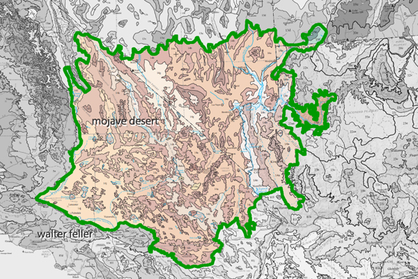
Around the Mojave

Describing areas outside the Mojave Desert is like connecting puzzle pieces to see the bigger picture. Here’s how it helps:

  1. Contextualizing the Mojave
    By comparing the Mojave to nearby regions, you show how it fits into the broader landscape. Whether it’s geology, hydrology, or human history, deserts like the Great Basin, Sonoran, and Colorado are all connected. For example, understanding ancient lake systems or fault lines often requires looking at neighboring regions.
  2. Highlighting Shared Processes
    Forces that shaped the Mojaveβ€”like plate tectonics, erosion, and hydrological changesβ€”didn’t stop at its borders. Studying areas outside the Mojave can reveal patterns and processes that help explain its features. For instance, the formation of Lake Manix makes more sense when compared to similar systems in the Basin and Range.
  3. Tracing Movement and Influence
    Human migration, animal movement, and water flow often cross regional boundaries. Exploring areas beyond the Mojave allows you to tell a more complete story. This is especially helpful for anthropological or archaeological studiesβ€”trade routes, trails, and cultural exchanges didn’t stay confined to one region.
  4. Strengthening Comparisons and Contrasts
    Describing other regions helps highlight what makes the Mojave unique. For example, comparing the Mojave’s dry lakebeds to the wetter remnants of Lake Cahuilla in the Colorado Desert shows the diversity of ancient hydrological systems.
  5. Providing a Broader Audience Appeal
    By linking the Mojave to surrounding areas, your project becomes more relevant to people interested in those neighboring landscapes. This makes the material more engaging and widely accessible.
  6. Holistic Understanding
    Nature doesn’t recognize human-made borders. To truly understand the Mojaveβ€”its past, present, and futureβ€”it’s helpful to look at it as part of a larger ecological, geological, and cultural network.

To really understand the Mojave–its history, what it is now, what might become of itβ€”viewing it in terms of a larger system, embracing nature, land features, and culture, is helpful. Alternatively, exploring areas out of the Mojave helps explain how this desert fits into a much larger story.

Ultimately, stepping beyond the Mojave’s boundaries allows you to provide depth and clarity, showing how this desert is part of a much bigger story.


Old and Local History

Old, local histories offer several benefits, particularly for those interested in understanding their community, heritage, or region in depth. Here are some of the key advantages:

1. Preserving Cultural Heritage

Local histories capture the stories, traditions, and customs of a specific area, ensuring they aren’t lost to time. These records help preserve the unique identity of a community and can be a source of pride for residents.

2. Understanding Historical Context

They provide insight into how a community or region developed, from its earliest days to the present. This context can help explain why things are the way they areβ€”like why a town was built in a particular spot or how its economy evolved.

3. Fostering Connection to Place

Local histories make people feel more connected to their surroundings. Learning about past residents, old landmarks, or forgotten events can create a deeper sense of belonging and appreciation for where you live.

4. Educational Value

These histories are invaluable resources for educators, researchers, and students. They offer specific examples of broader historical trends, such as migration, industrialization, or environmental changes, on a small, relatable scale.

5. Uncovering Hidden Stories

Local histories often highlight lesser-known stories or voices that might not appear in broader historical accountsβ€”such as those of indigenous peoples, women, or minority groups who played crucial roles in shaping the area.

6. Inspiration for Creative Work

Writers, artists, and filmmakers often draw inspiration from local histories to create works that bring these stories to life. They can be a goldmine for unique characters, dramatic events, and compelling narratives.

7. Guiding Modern Decisions

Understanding a region’s past can inform present-day decisions about planning, conservation, and development. Knowing what worked (or didn’t) in the past helps guide future actions.

8. Building Community

Sharing stories from a local history can bring people together, whether through historical societies, reenactments, or simply reminiscing. It strengthens communal ties and fosters intergenerational dialogue.

9. Highlighting Change and Continuity

Local histories show what has changed over time and what has stayed the same. This perspective can be both humbling and inspiring, reminding people of their resilience, adaptability, and enduring values.

10. Personal Connections

If your ancestors lived in a region, exploring its history can help you learn more about their lives and experiences, making genealogy research richer and more meaningful.

In short, old, local histories help us better understand the roots of our communities, connect to the past, and navigate the future. They’re like a treasure chest of lessons, stories, and wisdom waiting to be rediscovered!