Wonderland Ranch

https://digital-desert.com/wall-street-mill

Wonderland Ranch, also known as the Wall Street Mill area, is a historic site within Joshua Tree National Park. This area offers a glimpse into the region’s mining history and transformation into a national park. Here are some key points about its history:

  1. Early History: Before becoming part of Joshua Tree National Park, the area was used by Native American tribes such as the Serrano, the Chemehuevi, and the Cahuilla. The region’s resources were utilized for their livelihoods.
  2. Mining Era: The Wonderland Ranch area became significant during the California gold rush era. Bill Keys, a prominent local figure, owned and operated the Wall Street Mill, one of the area’s best-preserved mills. The mill was primarily used for crushing gold ore, which was essential in gold extraction processes.
  3. Bill Keys: A notable historical figure in the Joshua Tree area, Bill Keys played a pivotal role in local mining and community life. He was known for his resourcefulness and for being a central figure in the community’s development. Keys also had disputes with his neighbor, Worth Bagley, which led to a fatal shootout, adding a notorious chapter to the area’s history.
  4. Conservation and National Park: Joshua Tree’s ecological and geological significance led to its designation as a national monument in 1936 under President Franklin D. Roosevelt. Later, it was elevated to national park status in 1994. This change helped preserve the natural and historical resources, including the remnants of the Wonderland Ranch.

Today, visitors to Joshua Tree National Park can explore the historic sites around Wonderland Ranch, including the remains of the Wall Street Mill, old mining equipment, and the rustic landscapes that tell the stories of a bygone era of ambitious miners and rugged desert life.

The Story of Inyo

https://mojavedesert.net/history/the-story-of-inyo-chalfant/


“The Story of Inyo” by W.A. Chalfant is a comprehensive history of Inyo County, California, first published in 1922. W.A. Chalfant (1865-1943) was a newspaperman and historian who spent much of his life in the Eastern Sierra region of California. His work is considered one of the seminal histories of this part of California, detailing the early exploration, settlement, and development of Inyo County.

The book covers a wide range of topics, including the area’s indigenous peoples, the impact of European settlement, mining, and economic development, and the natural history and geography of the region. Chalfant’s writing is noted for its detailed research, engaging narrative style, and commitment to telling the stories of the Native American inhabitants and the settlers who came to the area.

Inyo County is a region of great diversity and contrast, home to some of the highest and lowest points in the contiguous United States, including Mount Whitney and Death Valley. This geographic and environmental diversity is reflected in the stories Chalfant tells, from tales of survival and adaptation in harsh landscapes to the boom and bust of mining towns and the ongoing challenges and conflicts over land and water use.

Mono Lake
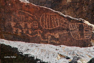
Petroglyphs

“The Story of Inyo” remains an essential resource for historians, geographers, and anyone interested in the American West, offering insights into the complex history of human and environmental interaction in this unique part of California.

https://mojavedesert.net/history/the-story-of-inyo-chalfant/

Paleontology

PALEONTOLOGY – Mojave Desert – Glossary of Terms and Definitions

mojavedesert.net › glossary › paleontology

The study of fossils and their relation to geologic time. … Paleontology Miocene fossils have been found in the cliffs of Red Rock Canyon. Scientists continue …

Mojave Desert Paleontology

The study of fossils and their relation to geologic time.

Paleontology in Red Rock Canyon

Wrightwood, Ca. Mountain Hardware Wrightwood, Ca. Canyon Cartography · DesertLink. Links to Desert Museums, Grizzly Cafe Family Dining …

Geology of the Mojave River

digital-desert.com › mojave-river › geology

The river flows below the surface for much of its length and only intermittently at the surface. The Mojave River, an arid desert lifeline, supplies water and …

Fossils, Rocks, and Time: Fossils and Rocks

digital-desert.com › paleontology › fossils-rocks

Geology : Paleontology. FOSSILS AND ROCKS. To tell the age of most layered rocks, scientists study the fossils these rocks contain. Fossils provide important …

Red Rock Canyon California State Park

digital-desert.com › red-rock-canyon

Red Rock Canyon State Park, Mojave California, Mojave Desert.

Fossils, Rocks, and Time: The Relative Time Scale

digital-desert.com › paleontology › relative

Geology : Paleontology. THE RELATIVE TIME SCALE. Long before geologists had the means to recognize and express time in numbers of years before the present …

Fossils, Rocks, and Time: The Numeric Time Scale

digital-desert.com › paleontology › numeric

Geologic time scale showing both relative and numeric ages. Ages in millions of years are approximate. Nineteenth-century geologists and paleontologists …

Fossils, Rocks, and Time: Fossil Succession

digital-desert.com › paleontology › succession

Geology : Paleontology. FOSSIL SUCCESSION. Three concepts are important in the study and use of fossils: (1) Fossils represent the remains of once-living …

Fossils, Rocks, and Time: Putting Events in Order

digital-desert.com › paleontology › order

Geology : Paleontology. PUTTING EVENTS IN ORDER. Scientists who study the past try to put events in their proper order. When we discuss events that happened …

Fossils, Rocks, and Time: Table of Contents

digital-desert.com › paleontology › index-frt

Geology : Paleontology. FOSSILS, ROCKS, AND TIME. INTRODUCTION. We study our Earth for many reasons: to find water to drink or oil to run our cars or coal …

FOSSIL – Mojave Desert – Glossary of Terms and Definitions

mojavedesert.net › glossary › fossil

The Fossil Canyon Loop Road is an interesting route for vehicle touring. … Mojave Desert Paleontology The study of fossils and their relation to geologic …

Fossils, Rocks, and Time: Rocks and Layers

digital-desert.com › paleontology › rocks-layers

Geology : Paleontology. ROCKS AND LAYERS. We study Earth’s history by studying the record of past events that is preserved in the rocks. The layers of the …

Mojave Desert – Scavenger

mojavedesert.net › glossary › scavenger

Paleontologists are … Raven – Desert Wildlife. Raven – Raven Also see > Bird: Omnivore : Scavenger: Predator: Diurnal Mammals – Predators Mountain Lion · …

Mojave Desert Geology

digital-desert.com › geology

Paleontology. The scientific study of prehistoric plants and animals in their geologic context. Alluvial material in dry wash. Dry Lake – Playa Desert Varnish …

Red Rock Canyon – Mojave California

digital-desert.com › red-rock-canyon › introduction

Located in the southern El Paso Mountains, these colorful cliffs with their stark beauty and unique features have attracted hikers, geologists, paleontologists, …

Cajon Pass Geology

digital-desert.com › cajon-pass › geology

Pliocene and Pleistocene evolution of the Mojave River, and associated tectonic development of the Transverse Ranges and Mojave Desert, based on borehole …

Dr. Joan S. Schneider

mojavedesert.net › people › schneider-joan

Mojave Desert History > Names in History. Dr. Joan S. Schneider. Photo of Dr Joan Schneider at Joshua Tree National Park Joan S. Schneider, Ph.D.

ANTIQUITIES – Mojave Desert – Glossary of Terms and Definitions

mojavedesert.net › glossary › antiquities

ANTIQUITIES – A general term for archaeological or paleontological resources which are at least 100 years of age and which tangibly represent or have the …

Lake Mead

digital-desert.com › lake-mead

Three of America’s four desert ecosystems–the Mojave, the Great Basin, and the Sonoran Deserts–meet in Lake Mead NRA. As a result, this seemingly barren area …

References – Mojave Preserve – California Mojave Desert

digital-desert.com › mojave-preserve › geology

Hewitt, D.F., 1956, Geology and mineral resources of the Ivanpah quadrangle, California and Nevada: U.S. Geological Survey Professional Paper 275, 172 p.

The Grand Canyon

digital-desert.com › grand-canyon

Grand Canyon National Park, a World Heritage Site, encompasses 1,218,375 acres and lies on the Colorado Plateau in northwestern Arizona. The land is semi-arid …

RELATIVE DATING – Mojave Desert – Glossary of Terms and …

mojavedesert.net › glossary › relative-dating

RELATIVE DATING – A method of dating rock layers by their relationships or proximity to each other. Both archaeologists and paleontologists use relative dating.

Elizabeth Campbell

mojavedesert.net › people › campbell-elizabeth

Elizabeth Campbell. Photo of Elizabeth Campbell, Mojave Desert archeologist. NPS photo – colorized. Elizabeth Warder Crozer was born in August of 1893 into a …

Grand Canyon natural environments

digital-desert.com › grand-canyon › natural

Near the Colorado River, riparian vegetation and sandy beaches prevail. Just above the river corridor a desert scrub community exists complete with a wide …

Kokoweef Caves

mojavedesert.net › desert-fever › kokoweef

Kokoweef and the mysterious river of gold in the Mojave Desert.

Cajon Pass Heritage

digital-desert.com › cajon-pass › cajon-fs-heritage

Heritage resources in the Cajon Pass region of the Mojave Desert.

Mojave Desert – Glossary of Terms and Definitions

mojavedesert.net › glossary

Mojave Desert Glossary. The following definitions may be helpful. In most instances, they may not be specific to, or, all-inclusive of, the Mojave Desert.

Kokoweef

digital-desert.com › kokoweef

If there were what may be trillions of dollars in gold lying at the bottom of an ‘unrediscovered’ river running from the Great Basin under the Mojave Desert to …

Rainbow Basin

digital-desert.com › rainbow-basin

Land ownership status can be found on the “Cuddeback Lake” Desert Access Guide. These BLM maps can be purchased from any California Desert District BLM …

Saline Valley Salt Tram

/saline-valley/salt-tram/

Photo of tramway tower in Saline Valley

The Saline Valley Salt Tram, also known as the Saline Valley Tramway, is a historic tramway system used to transport salt from the Saline Valley in California, USA. The Saline Valley is located within the Death Valley National Park.

The tramway was constructed in the early 20th century to facilitate the transportation of salt from the salt flats in the Saline Valley to the Owens Valley. The system consisted of cables and tramcars that carried salt over the Inyo Mountains. The salt was then transported to market via the Owens Valley.

The operation of the Saline Valley Salt Tram ceased in the mid-20th century, and the tramway itself has since fallen into disuse and disrepair. The remnants of the tramway, including some of the infrastructure and cables, can still be found in the Saline Valley. The area attracts historians, hikers, and those interested in exploring the remnants of historical infrastructure.

Desert Photography

Desert photography offers unique challenges and opportunities due to arid regions’ distinctive landscapes and lighting conditions. Whether you’re capturing vast dunes, rocky terrains, or desert flora and fauna, here are some tips to enhance your desert photography:

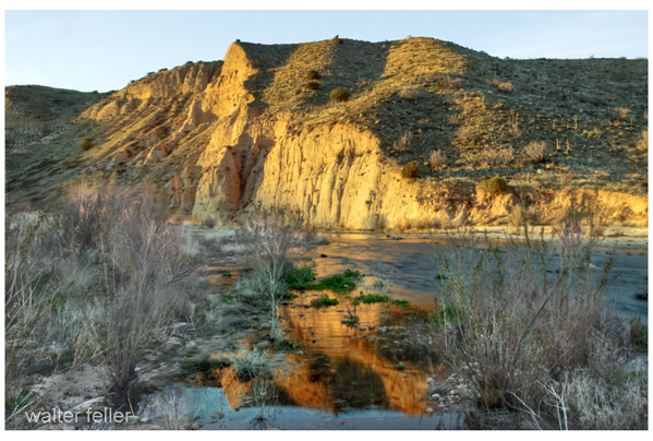
West Fork, Mojave River
  1. Golden Hours: The soft, warm light during the golden hours (shortly after sunrise and before sunset) can add a magical touch to your desert photos. Shadows are longer, and the colors become more vibrant, creating a pleasing atmosphere.
  2. Contrast and Textures: Deserts often feature striking contrasts between sand, rocks, and the sky. Emphasize these contrasts in your compositions to create visually appealing images. Pay attention to the textures of the sand or rocky surfaces.
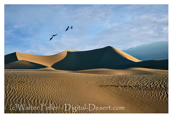
  3. Silhouettes: Use the strong sunlight to create silhouettes of desert features. This technique can be particularly effective when the sky has captivating colors during sunrise or sunset.
  4. Wide Angle for Landscapes: A wide-angle lens is great for capturing the vastness of desert landscapes. It lets you include expansive skies, sweeping dunes, or rocky formations in your frame.
  5. Macro Photography: Explore the smaller details of the desert environment with macro photography. Capture close-up shots of desert flowers, reptiles, or insects to showcase the intricacies of life in arid regions.
  6. Use a Polarizing Filter: A polarizing filter can help reduce glare from the sun on sand or rocks and enhance the colors of the sky. It’s particularly useful when photographing in midday sunlight.
  7. Capture the Night Sky: Deserts often have low light pollution, making them ideal for astrophotography. Consider capturing the night sky, stars, and celestial objects. Use a sturdy tripod and a wide aperture for long exposure shots.
  8. Add a Point of Interest: To give your photos a focal point, include an interesting subject such as a lone tree, a rock formation, or even a person in the vast desert landscape. This helps create a sense of scale and adds visual interest.
  9. Protect Your Gear: Deserts can be harsh with blowing sand and intense sunlight. Keep your camera and lenses protected when not in use, and consider using lens hoods or lens caps to prevent sand from damaging your equipment.
  10. Mind the Temperature: Be mindful of the temperature, especially in hot desert environments. Carry sufficient water, protect yourself from the sun, and take breaks to avoid heat-related issues.
Death Valley, Mesquite Dunes

Remember that each desert is unique, so take the time to explore and discover the specific features that make the desert you photograph special. Experiment with different compositions, lighting conditions, and perspectives to create captivating desert images.

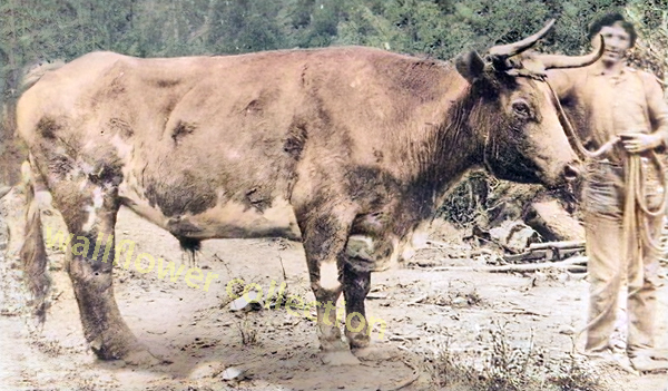
Old Crump

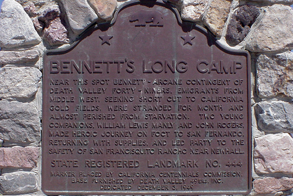
In 1849, a wagon train bound for California split up, with many members opting for a supposed shortcut to the goldfields. The shortcut did not work out, and these intrepid wanderers found themselves stranded, lock, stock, barrel, and four children on the floor of a place called ‘Death Valley.’

Bennett’s Long Camp

Over a month of hardship and waiting had passed while two heroic young men walked to find a way out and return with supplies to bring this band of Lost 49ers to safety. This they did, returning with food, a white horse, and a one-eyed mule. Sadly enough, the white horse had to be abandoned in a dry fall in the Panamint Mountains.

With these heroes returning, they could make their escape. The children were weak, tired, and sick and would not make the trip if they had to walk, so the pioneers sewed several shirts together, making saddlebags to carry them in.

The children were uncomfortable and sick. They cried, but ‘Crump,’ the ox selected to bear this burden, seemed to sense the importance of carrying its cargo as gently as possible, never missing a step, stumbling, or even making a sudden, jarring move.

This ordeal, beginning late in 1849 and finishing up early in 1850, became a distant memory to the party members.

Years later, a much older William Manly, one of the two heroes who saved the emigrants (John Rogers being the other), was walking down a road in the Central Valley. He noticed that over in a shady pasture, there was a fat ox relishing the long, tender blades of grass. Strangely enough, the ox looked vaguely familiar. Sure enough, it was Old Crump, warm and gentle as ever.

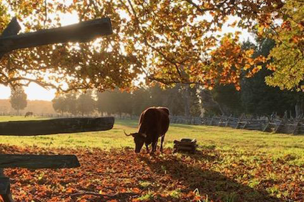
Ox in pasture of green grass
Retired beast of burden – NPS photo

Back in 1850, when things settled after their hardship-fraught journey and arrival at their destination, the owner of the ox retired the creature as a reward for its distinguished service, and Crump never worked another day in his life.

Chapter XI – Death Valley in 49
Wm. Lewis Manly

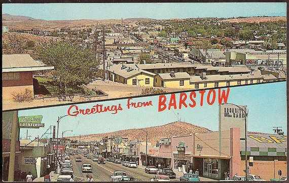
Barstow, California

https://digital-desert.com/barstow-ca/

.

  1. Early Inhabitants: The Barstow area was originally inhabited by Native American tribes, including the Mojave people, for centuries before European settlers arrived.
  2. Railroad History: Barstow’s modern history began with the arrival of the Atchison, Topeka, and Santa Fe Railroad in the late 19th century. The railroad played a significant role in the city’s development, as it was a vital stop on the transcontinental rail line, connecting the eastern United States to the West Coast.
  3. Water Stop and Rail Depot: Barstow served as an important water stop for steam locomotives, providing a place for trains to refill their water tanks in the desert. The city also became a key rail depot and maintenance facility.
  4. Name Change: Originally known as Waterman Junction, the city’s name was changed to Barstow in 1886 in honor of William Barstow Strong, a president of the Santa Fe Railroad.
  5. Route 66: In the early 20th century, Barstow became an integral part of the iconic Route 66, the “Main Street of America,” connecting Chicago to Los Angeles. The city thrived as a popular stopping point for travelers on this historic route.
  6. Military Presence: During World War II, Barstow’s population grew due to the establishment of the Marine Corps Logistics Base Barstow and the nearby Fort Irwin National Training Center, which continue to play significant roles in the local economy.
  7. Modern Times: Barstow remains a transportation center today, situated at the junction of Interstates 15 and 40. It continues to serve as a rest stop for travelers and a transportation and logistics hub for goods moving across the country.
  8. Historical Landmarks: The city has preserved its historical heritage, with several landmarks and museums, including the Route 66 Mother Road Museum and the Western America Railroad Museum, showcasing its rich transportation history.

Barstow’s history is deeply intertwined with the development of transportation networks, from the railroad to Route 66 and modern interstate highways. Today, it remains an essential point of access and commerce for those traveling through the Mojave Desert in Southern California.

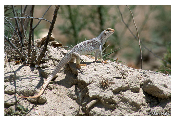
The Fascinating World of the Desert Iguana

Introduction:

The desert iguana, scientifically known as Dipsosaurus dorsalis, is an unusual reptile that thrives in the arid regions of North America. This lizard captures scientists’ and nature enthusiasts’ attention with its remarkable adaptations and intriguing behaviors. In this fascinating world of the desert iguana, explore its appearance, habitat, diet, reproduction, and challenges in its harsh environment.

Appearance:

The desert iguana is a medium-sized lizard, typically measuring 10 to 16 inches long. Its body is covered in rough, grayish-brown scales, which help it blend seamlessly with its surroundings. One of the most distinctive features of the desert iguana is the row of large, spiky scales that run down its back and tail, providing protection and aiding in thermoregulation. These unique scales also contribute to its overall appearance, making it a visually striking creature.

Habitat:

As the name suggests, the desert iguana inhabits arid and semi-arid environments such as deserts, rocky areas, and shrublands. It can be found in regions spanning the southwestern United States, including California, Nevada, Arizona, and parts of Mexico’s Baja California peninsula. These reptiles have evolved to withstand extreme temperatures. They can often be seen basking in the sun to absorb warmth while seeking shelter in burrows or under rocks during the day’s hot hours.

Diet:

The desert iguana is primarily herbivorous, with its diet consisting mainly of fruits, flowers, leaves, and the occasional insect. Despite the scarcity of vegetation in its habitat, this lizard has adapted to efficiently extract moisture from its food, enabling it to survive in arid conditions. By consuming a variety of plants, the desert iguana plays an important ecological role in seed dispersal, contributing to the diversity and regeneration of its habitat.

Reproduction:

Breeding usually occurs during the spring, when temperatures are more favorable for the survival of the hatchlings. Males engage in territorial displays, showcasing their vibrant colors and engaging in push-up contests to establish dominance. Once mating occurs, females lay clutches of eggs in sandy soil, carefully choosing locations that provide suitable conditions for incubation. After an incubation period of approximately 60 to 75 days, the hatchlings emerge, equipped with the instinctual knowledge to navigate their environment.

Challenges and Conservation:

The desert iguana faces several challenges in its harsh habitat. Urban development, habitat fragmentation, and climate change pose significant threats to its survival. These factors, coupled with illegal collection for the pet trade, have led to declining population numbers in certain areas. Conservation efforts, such as protected areas and public awareness campaigns, are crucial in ensuring the long-term survival of this remarkable species.

Conclusion:

The desert iguana, with its unique adaptations and ability to thrive in the arid regions of North America, is a testament to the resilience of nature. As we continue to explore and appreciate the diversity of our planet, it is vital that we work towards preserving and protecting species like the desert iguana. By understanding and respecting these incredible creatures, we can contribute to their conservation and ensure that future generations can also marvel at their fascinating presence in the desert landscapes.