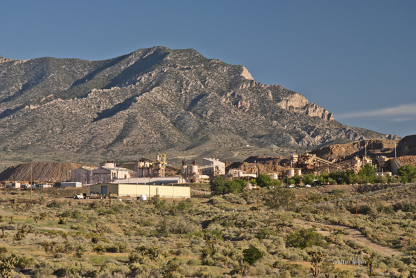
Mountain Pass, California, is an unincorporated community in San Bernardino County near the Nevada border along Interstate 15. It lies on the south flank of the Clark Mountain Range at about 4,730 feet in elevation. Before its transformation into a rare earth mining hub, Mountain Pass was part of a high desert rangeland used for cattle grazing and seasonal travel.
In the late 1800s, ranchers from Ivanpah and the Mojave River region grazed cattle along the area’s sparse grasslands and natural springs. By the early 1900s, a few homesteads, corrals, and line camps appeared, but permanent settlement was limited due to aridity and isolation. The nearest centers of activity were Cima and Ivanpah, tied to the Union Pacific line.
During the 1920s and 1930s, open-range ranching declined as highway construction and mineral exploration expanded. U.S. Highway 91, built through Mountain Pass in the 1930s, connected Barstow and Las Vegas and reshaped movement across the desert. Prospectors began testing local outcrops for copper, fluorspar, and uranium.
In 1949, while searching for uranium, geologists discovered bastnasite—a mineral rich in rare earth elements. By 1952, Mountain Pass Mine was in production, marking the shift from ranching to mineral extraction. The mine’s bastnasite ore, containing about 7% rare-earth oxides, proved exceptionally rich. Throughout the 1960s, 1970s, and 1980s, Mountain Pass supplied most of the world’s rare earth elements, which are critical for electronics and defense.
Environmental concerns and global competition, particularly from China, led to a decline in the 1990s. A series of wastewater pipeline spills and stricter regulations led to the closure in 2002. Molycorp reopened the site in 2010 but went bankrupt in 2015. MP Materials acquired it in 2017 and restarted production, now emphasizing on-site recycling and domestic refining. Mountain Pass currently produces 10–15 percent of global rare earth supply and remains the only major U.S. operation of its kind.
Timeline:
Late 1800s – Early cattle grazing begins between the Clark and Mescal Ranges. 1890s–1910s – Small ranchers and homesteaders establish corrals and wells near Cima and Ivanpah. 1920s – Ranching continues; U.S. Highway 91 construction increases access. 1930s–1940s – Grazing declines; mineral prospecting grows. 1949 – Bastnasite discovered while prospecting for uranium. 1952 – Mountain Pass Mine begins rare earth production. 1960s–1980s – Peak years; mine supplies most of the world’s rare earth elements. 1980s–1990s – Environmental issues and foreign competition led to a decline. 2002 – Mine ceases operations. 2010 – Molycorp reopens the mine. 2015 – Molycorp declares bankruptcy. 2017 – MP Materials resumes production. 2020s – Expansion of domestic processing and magnet manufacturing.
Mountain Pass stands as a symbol of changing desert economies—from open-range cattle country to strategic mineral industry—each era leaving its own traces: windmills, corrals, and open pits scattered across the Mojave’s high desert plain.
Johann George Ecker led a group of German and Swiss immigrants who settled in the Antelope Valley in 1886, founding a small colony they called Palmenthal—named for the nearby Joshua trees, which they mistook for palms. These settlers sought to establish a self-sufficient farming community on the high desert plain. Drawing from their European roots, they introduced cooperative labor, community organization, and dry-farming methods suited to the arid conditions. Early crops included barley, wheat, and fruit orchards, with irrigation ditches dug by hand to capture scarce water. Despite their determination, drought and isolation made survival difficult, and by the early 1890s, many settlers left. Still, their legacy endured in the renamed settlement of Palmdale, marking the valley’s first organized agricultural community.
Palmenthal was the original German-Swiss settlement that became Palmdale, California. Founded in 1886 by Johann George Ecker and a group of immigrant families from Germany and Switzerland, the colony was located near present-day 20th Street East and Avenue Q. The settlers named it Palmenthal, or “Palm Valley,” after mistaking the native Joshua trees for palms.
They arrived with hopes of building a cooperative farming community, bringing European agricultural practices and traditions with them. Using dry-farming methods, they planted barley, wheat, and fruit orchards, and attempted small-scale irrigation projects to make the desert productive. The settlers built simple homes, a school, and community facilities, establishing the first structured settlement in the Antelope Valley.
Life in Palmenthal was harsh. Repeated droughts, crop failures, and the isolation of the high desert took their toll. Within a few years, many families abandoned the colony, some moving closer to the Southern Pacific Railroad line near Harold, where water and transport were more reliable. By the early 1890s, Palmenthal was largely deserted, but its spirit persisted in the nearby settlement that would evolve into modern Palmdale.
The story of Palmenthal represents the first organized effort to colonize and cultivate the Antelope Valley—an experiment in community and endurance that laid the groundwork for future growth in the region.
Timeline
1886 – Johann George Ecker and a group of German and Swiss immigrants establish the settlement of Palmenthal in the Antelope Valley, naming it for the Joshua trees they mistake for palms.
1887 – The settlers begin dry farming and plant wheat, barley, and fruit orchards. A small schoolhouse and community hall are built.
1888 – Severe drought conditions make farming difficult. Wells yield limited water, forcing the settlers to haul water from distant springs.
1889 – Some families leave the settlement due to crop failures and the isolation of the high desert.
1890 – Remaining settlers attempt to improve irrigation by digging ditches and small reservoirs, but lack of rainfall continues to hinder success.
1891 – The Southern Pacific Railroad establishes a station several miles west, prompting some settlers to relocate closer to the line for better access to supplies and transport.
1892 – Palmenthal is largely abandoned. The remaining residents consolidate around the new rail siding area that becomes known as Palmdale.
1893 – The name Palmdale replaces Palmenthal, marking the transition from the failed colony to the town that would endure.
Colonel Albert G. Boyd’s influence on aviation in the Antelope Valley during the 1940s was profound and lasting.
Born in 1906, Boyd joined the Army Air Corps in the 1920s and developed a reputation as both a skilled pilot and a meticulous engineer. When he took command of Muroc Army Air Field in 1945, the base was still a relatively primitive outpost in the Mojave Desert, used primarily for gunnery and bombing practice during World War II. Boyd recognized the potential of the area’s wide, dry lakebeds and clear weather for testing experimental aircraft.
Under his direction, Muroc was reorganized into a formal testing and research facility. Boyd introduced structured engineering methods to flight testing—demanding that pilots follow precise test protocols, record accurate data, and collaborate directly with engineers. This disciplined approach replaced the earlier, more informal trial-and-error methods that had dominated aviation testing.
He personally flew and supervised tests of many of the era’s most advanced aircraft, including the P-80 Shooting Star (the first operational U.S. jet fighter), the XP-84 Thunderjet, and the XP-86 Sabre. Boyd also selected and mentored test pilots who would go on to fame, including Chuck Yeager, who broke the sound barrier in 1947 in the Bell X-1—an event made possible by Boyd’s groundwork in developing a safe, scientific test environment.
By 1949, Muroc had been renamed Edwards Air Force Base, and Boyd became its first commander under the newly formed U.S. Air Force. His influence extended to the creation of the Air Force Test Pilot School, which formalized the training of test pilots and engineers.
Boyd’s leadership established the Antelope Valley as the epicenter of experimental flight, directly shaping America’s Cold War aerospace industry. His legacy earned him induction into the National Aviation Hall of Fame in 1984 and enduring recognition as the “Father of Modern Flight Testing.”
Pearl L. (Allan) Lockheed’s story ties neatly into the larger evolution of aviation in Southern California and the Antelope Valley’s rise as an aerospace center. Here’s a fuller picture of that 1930s connection:
Allan Haines Loughead, who later respelled his name as “Lockheed” to simplify pronunciation, co-founded the original Lockheed Aircraft Company with his brother Malcolm in 1916 in Santa Barbara. Their first successful aircraft, the Model G seaplane, led to several innovative designs before the company went dormant in the 1920s due to financial hardship. In 1926, investor Fred Keeler and engineer Jack Northrop revived the brand as the Lockheed Aircraft Corporation in Hollywood, and by the early 1930s its headquarters had moved to Burbank.
During this period, Lockheed’s engineers were testing high-performance designs that demanded broad, open airfields far from populated areas. The Antelope Valley—with its dry climate, smooth alkali flats, and absence of air traffic—offered perfect conditions. Company pilots, mechanics, and test crews used open tracts near Lancaster and Muroc Dry Lake for proving flights, performance trials, and long-distance endurance runs. Aircraft such as the Lockheed Vega, made famous by pilots like Wiley Post and Amelia Earhart, were occasionally tested in these desert settings to assess handling and engine reliability under extreme heat and dust conditions.
These early desert test flights did more than validate aircraft—they demonstrated the region’s unmatched utility for flight experimentation. Word of the valley’s favorable flying conditions spread quickly through the Southern California aviation community, influencing later government and industry decisions. By the late 1930s, Muroc Dry Lake had been adopted by the Army Air Corps as a training and test site, the foundation of what became Edwards Air Force Base. Lockheed’s early desert work thus helped pave the way—both literally and figuratively—for the Antelope Valley’s transformation into America’s aerospace heartland.
Would you like me to include a short timeline of Lockheed’s Antelope Valley involvement leading up to World War II?
Timeline – Pearl L. (Allan) Lockheed and the Antelope Valley
1916 – Allan and Malcolm Loughead establish the Loughead Aircraft Manufacturing Company in Santa Barbara. They produce innovative seaplanes but struggle financially after World War I.
1926 – The Lockheed Aircraft Corporation is formed in Hollywood by a group of investors who revive the Loughead name and employ engineer Jack Northrop. The company quickly earns a reputation for strong, streamlined aircraft.
1927 – The first Lockheed Vega is built in a small shop in Hollywood. Designed for speed and endurance, it became one of the most successful aircraft of its time.
Late 1920s – Test flights begin taking advantage of Southern California’s wide, dry basins. Open areas north of Los Angeles, including the Antelope Valley, are occasionally used for long-range testing due to their flat terrain and low population density.
1930 – Lockheed relocates to Burbank, expanding production of the Vega, Air Express, and Orion aircraft. Pilots testing these aircraft frequently utilize the high desert for performance runs and navigation trials.
Early 1930s – As aircraft speeds increase and test safety becomes a growing concern, engineers and pilots continue to explore isolated desert fields near Lancaster and Muroc Dry Lake for proving flights. These flights help identify the area’s potential for larger-scale aviation operations.
Mid-1930s – Lockheed’s reputation for precision engineering attracts both private and government attention. The Antelope Valley becomes recognized within aviation circles as an ideal environment for high-speed, high-altitude testing.
1937 – The U.S. Army Air Corps begins using Muroc Dry Lake for training and gunnery practice, laying the foundation for what will become Muroc Army Air Field in 1938. Lockheed’s earlier presence in the area helps establish its suitability for military and industrial testing.
By the end of the 1930s, Lockheed was producing advanced aircraft such as the Model 14 Super Electra, and the Antelope Valley’s airfields were becoming integral to regional aerospace testing. These developments mark the beginning of the desert’s long association with flight research, innovation, and the aerospace industry that would define it in the decades to come.
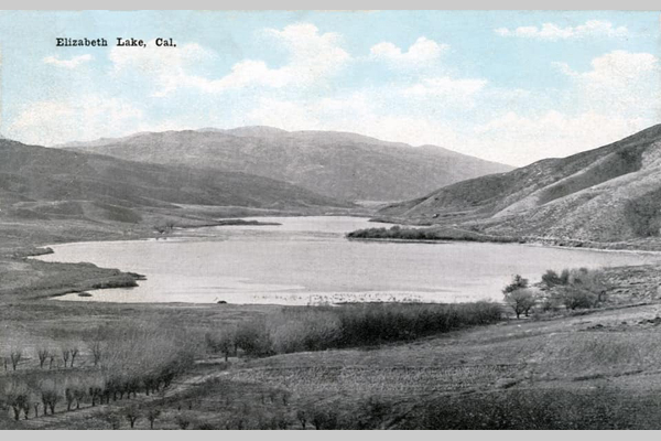
Francisco “Chico” Lopez was an early Californio rancher whose name became attached to what is now Elizabeth Lake, once widely known as La Laguna de Chico Lopez.
He was part of the Lopez family that held long-standing land and grazing rights in the western Antelope Valley during the Mexican and early American periods of California. The Lopez holdings were associated with the Rancho San Francisco grant, centered near present-day Newhall. Still, their herds often ranged north and west into the Sierra Pelona and Antelope Valley foothills.
By the 1840s, Chico Lopez was running sheep and cattle in the region surrounding the lake. Travelers and surveyors used his name to identify the landmark—“Chico Lopez’s Lake” or “La Laguna de Chico Lopez.” The lake served as a watering stop along the early trails crossing the San Andreas rift zone between Soledad Canyon and theAntelope Valley.
Later, as American settlers arrived in the 1860s and 1870s, the Lopez name persisted in maps and local speech until the site was renamed Elizabeth Lake. The renaming is attributed to surveyor Benjamin Davis Wilson (Don Benito Wilson), who supposedly named it for a relative or acquaintance during his expeditions through the area.
Though details of Chico Lopez’s later life are scarce, his legacy survives in the early place-name and in the transition from the Californio ranching era to the American homesteading period in the western Mojave frontier.
Born in 1825 in Bastard Township, Leeds County, Upper Canada (now Ontario). He was the son of Nathaniel and Jane Stoddard and brother to Sheldon, Albert, and Rufus. The family later converted to Mormonism and joined the westward migration.
Traveled with a Mormon emigrant company under Charles C. Rich around 1852 to 1853. Reached the Salt Lake Valley in Utah, then continued west into California by the mid-1850s, likely entering through Cajon Pass. Settled in the San Bernardino area with other early pioneers.
Moved into the Mojave region during the late 1850s or early 1860s. Established or drilled Stoddard Well, which became a vital water source for travelers. Helped develop the Stoddard Wells Road, an important freight and emigrant route between Victorville and Barstow. Supported freighting operations and ranching efforts in the Victor Valley. Worked closely with his brother Sheldon, who was also active in transportation and settlement.
Stoddard Wells became a lasting geographic landmark and stop along desert routes. The road provided improved access for mining, settlement, and commerce. His work reflected the hands-on pioneer ethic of building essential infrastructure in difficult terrain. Remembered locally as one of the Stoddard brothers, among the earliest trailblazers of the Mojave Desert.
Remained in Southern California into the late 19th century. Died in 1914. His name endures through landmarks like Stoddard Wells, which commemorate his role in opening the Mojave to travel and settlement.
Arvin’s story illustrates the shift from Mormon settlement to broader regional development across Southern California. His contributions supported the growing network of trails, roads, and water sources that made desert travel possible. He stands as an example of the practical, industrious pioneers who built the foundation for future desert communities.
Sheldon Stoddard Early pioneer and Mormon settler who helped establish routes, wells, and communities along the Mojave River during California’s frontier expansion.
Upper Mojave River Trail Historic travel corridor following the upper Mojave River, connecting early settlements, ranches, and stage stops between Cajon Pass and Barstow.
Stoddard Wells Road Historic wagon route branching from the Mojave River Trail, used by settlers and freighters linking San Bernardino with desert mining districts.
Stoddard Well A vital water source established by the Stoddard brothers and later maintained by Hiram Hartman, serving travelers and stockmen crossing the high desert.
Pioneers Early settlers who braved the Mojave frontier, building wells, trails, and communities that shaped the foundation of inland Southern California.
San Bernardino Regional center and supply hub for Mormon settlers and desert pioneers, serving as gateway to the Mojave and points east during westward expansion.
Fish Ponds Artificial ponds along the Mojave River near Stoddard Wells, providing food and water resources for ranchers and travelers in the arid landscape.
Mormon Crossing Historic Mojave River ford near present-day Victorville, used by Mormon pioneers and freighters traveling between San Bernardino and Salt Lake City.
Mojave River An intermittent desert river flowing underground much of its course, sustaining life, travel, and settlement along California’s inland frontier.
The “frontier ethos” refers to the cultural attitude and moral outlook shaped by life on a frontier—where civilization meets wilderness, and individuals must rely on toughness, ingenuity, and self-reliance to survive and prosper. It’s both a historical mindset and a national myth, most famously tied to the American West.
Here’s a breakdown of its key traits and origins:
Self-reliance and independence On the frontier, people couldn’t depend on distant authorities or established systems. They had to make their own shelter, find their own food, and solve their own problems. This bred a strong belief in individual responsibility and personal liberty.
Ingenuity and practicality Frontier conditions required resourcefulness. Settlers and pioneers learned to adapt, invent, and repurpose what they had—traits that became central to the American ideal of innovation and “Yankee know-how.”
Courage and endurance The frontier demanded physical and moral toughness. People faced isolation, harsh climates, and conflict, all of which became symbols of endurance and determination.
Optimism and expansionism The frontier ethos was also fueled by the belief that progress and opportunity lay just beyond the horizon. This optimism became tied to Manifest Destiny—the conviction that expansion westward was both inevitable and righteous.
Community and cooperation Despite the focus on rugged individualism, survival often depended on cooperation. Settlers banded together to build towns, schools, and churches, reflecting a balance between independence and mutual reliance.
Moral and religious undertones Many saw the frontier as a proving ground for moral virtue and divine purpose. Hard work, thrift, and faith were often viewed as evidence of good character and divine favor.
Historian Frederick Jackson Turner famously argued in his 1893 “Frontier Thesis” that this ethos defined the American character itself—shaping values of democracy, equality (within limits), and restless ambition. Even after the physical frontier closed, the “frontier spirit” lingered as a national ideal—expressed in space exploration, technology, and the belief that challenges can be overcome through grit and creativity.
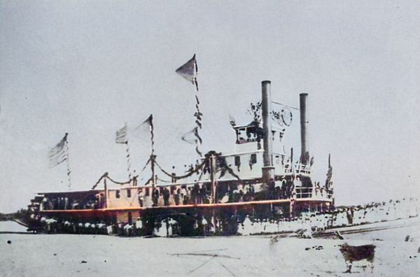
Lingenfelter’s Steamboats on the Colorado River, 1852–1916 provides an implicit social and economic history of every settlement that grew—or faded—along the river’s banks. The book’s narrative threads the growth of these river communities directly to the rise and fall of steamboat commerce.
Yuma and Arizona City
Origins: Fort Yuma (established 1850) was the main reason steamboats came to the river at all. Its chronic supply shortages prompted the launch of the Uncle Sam in 1852—the first river steamer.
Growth: Johnson’s General Jesup and later steamers transformed the isolated post into a trade hub. Yuma Indians, Cocopahs, and early merchants (Louis Jaeger, George Hooper, Mrs. Bowman “the Great Western”) were central to its development.
Outcome: Arizona City (later Yuma) became the permanent entrepot for the Arizona interior, surviving floods that wiped out rival settlements (Jaeger City and Colorado City) in 1862.
Steamboat impact: Yuma existed because of river transport—its food, freight, mail, and even building materials came upriver. The steamboat wharf and wood yards formed its economic heart until the Southern Pacific Railroad bridge was completed in 1877.
Fort Mohave and the Mojave Valley
Military anchor: Established in 1859 after Lt. Col. Hoffman’s expedition. Johnson’s General Jesup and Colorado carried the troops and artillery upriver.
Settlement influence: The fort’s constant freight and troop movements supported a network of wood-cutters, ferrymen, and small traders. Mohave and Chemehuevi Indians interacted with the garrison, at first through hostility, later trade.
Mining connection: Steamboats supplied nearby mining districts such as Eldorado Canyon, which developed into a key upriver port. Freight was landed directly from San Francisco via Johnson’s line, showing how the steamboat system enabled northern Arizona’s first mineral exploitation.
Ehrenberg (originally Mineral City)
Origins: Founded in the 1860s as a wood yard and landing above La Paz.
Growth: When gold was discovered at La Paz (1862), Johnson’s boats (Cocopah, Gila) ran regular trips, and the landing evolved into Mineral City—later renamed Ehrenberg.
Economic role: It became the principal upriver port for western Arizona mining. Merchants, assay offices, and stage connections tied it to Prescott and Wickenburg.
Decline: As river levels shifted and the railroad advanced toward Needles, Ehrenberg’s role diminished; by the 1890s, it had reverted to a small ferry and freight stop.
La Paz
Discovery and boom: Founded after the 1862 placer rush at Laguna de la Paz, fifty miles above Yuma.
Steamboat role: Johnson’s Cocopah and Colorado II made it a thriving port for a few years; millions in gold dust and supplies moved through its landing.
Community effects: Temporary but intense—stores, saloons, and a post office sprang up almost overnight. The town declined after the placers gave out, though it remained a shipping point for freighting routes into central Arizona.
Callville and Eldorado Canyon
Callville: Established in 1864 by Mormons under Anson Call as the uppermost navigable landing on the Colorado. Johnson’s Mojave II and the Gila reached it with supplies for Mormon colonies.
Eldorado Canyon: The river link to Nevada’s silver mines. Steamers delivered ore machinery and carried bullion out. Lower Camp and Hardyville (later Bullhead City) also grew as logistical points for these mines.
Outcome: The decline of mining and the development of railroads at Needles ended their importance, but their brief steamboat era left physical and place-name legacies.
Hardyville, Needles, and the Mojave Crossing
Hardyville: Founded by William Hardy in the 1860s near Fort Mohave as a landing and ferry for freight into northern Arizona and served by Johnson’s and later Polhamus’s boats (Gila, Mohave II).
Needles: Grew later from the same corridor once the railroad bridged the river. For a time, both rail and steamboat freight were interdependent—boats ferried heavy goods to and from the rail terminus.
Cultural tie: These settlements owed their early survival to the steamboat’s ability to deliver goods to otherwise inaccessible desert outposts.
Mexican Delta Settlements
Robinson’s Landing and Port Isabel: Transfer points where sea-going schooners met the river steamers. These landings, although primitive, were the logistical lifeline between San Francisco and Arizona before the rail era.
Cocopah and Yuma labor: River tribes provided the essential wood-cutting and loading labor at these lower landings. The steamboat economy reshaped indigenous life, drawing them into the wage economy.
Later decline: When the Imperial Canal and Laguna Dam diverted the river (1905–1909), most of these delta landings were abandoned or submerged.
Imperial Valley and the Lower Colorado (20th century)
Engineering phase: The Searchlight and St. Vallier were used by the California Development Company and the Reclamation Service to ferry materials during the Imperial Valley flood and Laguna Dam projects (1905–1909).
New communities: Mexicali, Calexico, and Imperial grew directly from these river engineering efforts—the last chapter of the steamboat’s social influence.
Summary of Broader Community Ties
Military Supply: Forts Yuma and Mohave created permanent river commerce.
Civic Formation: Yuma, Ehrenberg, and Hardyville evolved from wharves and woodyards into lasting towns.
Cross-Cultural Exchange: Cocopah, Yuma, and Mohave tribes were drawn into trade and labor systems, profoundly altering their economies.
Transition and Legacy: As railroads and dams replaced steamers, most of these towns either adapted (Yuma, Needles) or faded (La Paz, Callville).
In essence, the steamboats were the architects of civilization along the Colorado River. Every settlement from the Gulf to Callville began as a landing, woodyard, or ferry point tied to the fleets of Johnson, Polhamus, and their successors. When the engines fell silent in 1916, the towns they had spawned remained—the permanent human footprint of the river’s steamboat age.
Timeline of Steamboats and River Communities along the Colorado River, 1539–1916 (based on Richard E. Lingenfelter, Steamboats on the Colorado River, 1852–1916, University of Arizona Press, 1978)
1539 Francisco de Ulloa becomes the first European to sight the mouth of the Colorado River while exploring the Gulf of California for Spain.
1540 Hernando de Alarcón sails into the river delta, establishing it as a navigable waterway in Spanish maps.
1781 Mission San Pedro y San Pablo de Bicuñer is founded near the river and soon destroyed in native uprisings; Spanish efforts to settle the lower Colorado end.
1849 California Gold Rush brings heavy overland migration; Dr. Lincoln establishes a ferry at Yuma Crossing to serve travelers heading to the gold fields.
In 1850, Fort Yuma was founded to protect emigrants; supplies were freighted overland at ruinous cost.
In 1850, Lt. George H. Derby attempted to deliver supplies by sea aboard the schooner Invincible but failed due to Hardy’s erroneous map of the Colorado estuary.
In 1852, Captain James Turnbull launched the Uncle Sam, the first steamboat on the Colorado River, assembled near the mouth. She reaches Fort Yuma in December but later sinks.
In 1853, George A. Johnson, Ben Hartshorne, and Captain Alfred Wilcox established a freight company and began regular steam navigation with the General Jesup in January 1854.
1854 General Jesup proves commercial success; Fort Yuma and nearby settlements (Yuma Crossing, Jaeger’s Ferry) grow rapidly.
1855–1856 Additional woodyards established along the lower river; Johnson expands his business.
In 1857, Lt. Joseph C. Ives is assigned to explore the river’s head of navigation with the steamer Explorer.
In 1858, Ives launches the Explorer and ascends the river to Black Canyon; George Johnson’s General Jesup reaches nearly the same point earlier, demonstrating practical navigation to Pyramid Canyon.
In 1859, Fort Mohave was established at Beale’s Crossing; Johnson’s Colorado and Cocopah transport troops and supplies upriver. The Mohaves subdued after brief hostilities.
1859 Cocopah launched, the largest and most powerful stern-wheeler on the river to date; it began freight runs between the Gulf and upriver forts.
1860 Steamers in regular service to both Fort Yuma and Fort Mohave; landings and wood-yards form the nuclei of new settlements.
1861 Johnny Moss discovers silver in Eldorado Canyon; the first mining boom supported by river transport begins.
1862 Great Colorado River gold rush; La Paz and Mineral City (later Ehrenberg) were established as upriver mining and freight centers. Yuma (Arizona City) grows rapidly.
1863 Arizona Territory created; steamboats supply frontier posts, mines, and settlements along the river corridor.
In 1864, Mormon colonists founded Callville as the uppermost navigable port on the river; Mohave I and Gila reached it with freight and supplies.
1864–1865 Floods destroy Jaeger City and Colorado City; Arizona City (Yuma) survives and becomes the dominant port.
1866 Hardyville (later Bullhead City) founded as river landing and ferry opposite Fort Mohave.
1867–1870 Johnson’s fleet expanded with Cocopah II, Mohave II, Gila, and Colorado II; regular commercial runs between Gulf and Hardyville.
1870s Ehrenberg (formerly Mineral City) and La Paz prosper as supply depots for mining districts. Yuma thrives as regional capital and customs point.
1877 Southern Pacific Railroad reaches Yuma; rail begins to replace river freight to Fort Yuma and interior Arizona.
1880s Decline of Johnson’s monopoly; smaller independent boats like Searchlight and St. Vallier begin service for construction and local trade. Needles develops as rail terminal at Mojave Crossing.
1890s Limited steamboat service continues for miners and settlers between Yuma and Needles; smaller upper-river craft like Undine and Comet work in Green and Glen Canyons.
1905 Catastrophic flooding of the Imperial Valley (Salton Sink) creates major river diversion works. Steamboats carry rock, equipment, and workers to repair the break.
1907–1909 Construction of Laguna Dam; dredges Alpha, Beta, and Delta assist in engineering works. River settlements (Mexicali, Calexico, Imperial) expand.
1910–1916 Final years of commercial operation; the Searchlight and St. Vallier continue limited freight and survey work.
1916 Steamboat era ends; the last operational vessel, Searchlight, retires. The Colorado’s navigation frontier gives way to railroads and irrigation infrastructure.
Summary: The river towns—Yuma, La Paz, Ehrenberg, Hardyville, Callville, and others—each owe their existence to this 64-year steamboat epoch. The boats linked mining, military, and agricultural settlements from the Gulf of California to southern Nevada, and their decline marked the end of the Colorado River as an open commercial highway.
Connectivity along the Colorado River, 1852–1916 (based on Richard E. Lingenfelter’s Steamboats on the Colorado River, 1852–1916, University of Arizona Press, 1978)
The Colorado River functioned as a living transportation spine for the American Southwest. From the Gulf of California to the mouth of the Virgin River, its steamboat era linked ports, mines, forts, and settlements into a single continuous system of movement and exchange. The following summarizes how this connectivity developed—its physical, economic, and cultural dimensions.
1. The River as Transportation Artery
Before railroads, the Colorado was the only practical route through an otherwise impassable desert frontier. Steamboats transformed it from a natural barrier into a corridor of movement:
Vertical Integration: Cargoes from San Francisco and Mexican ports entered at the Gulf of California and were transferred at Robinson’s Landing or Port Isabel to shallow-draft river steamers.
Main Route: Steamers ran 600 miles upriver from the estuary to the head of navigation at Callville, with landings every 25–40 miles at woodyards and supply camps.
Branch Distribution: From these landings, mule and wagon roads carried freight to mining camps—La Paz, Wickenburg, Prescott, Eldorado Canyon, and beyond.
The river linked Pacific maritime trade directly to Arizona’s interior economy, reducing freight costs from $500 a ton (overland) to $75 or less.
2. Economic Connectivity: The Steamboat Network
Each segment of the river supported distinct but interlocking economies:
Lower River (Gulf to Yuma):
Served by General Jesup, Colorado I–II, and Cocopah boats.
Functioned as the supply chain for Fort Yuma, Arizona City, and Cocopah/Yuma tribal labor networks.
Exports: military supplies outbound; imports: grain, hides, and ore from upriver.
Middle River (Yuma to Fort Mohave):
Connected through Gila, Mohave, Cocopah II.
Supported ranching, freighting, and mining from La Paz, Ehrenberg, and Mineral City.
Fort Mohave provided stability and demand; nearby Hardyville became the main transfer point to the northern interior.
Upper River (Fort Mohave to Callville):
Connected through seasonal navigation, reaching Eldorado Canyon and Callville, linking Mormon settlements and Nevada mines.
Steamboats supplied machinery, food, and mail to isolated canyons and hauled bullion downstream.
These tiers formed an interdependent flow of goods and people—San Francisco → Gulf → Yuma → La Paz → Hardyville → Callville—binding together three territories: California, Arizona, and Nevada.
3. Military and Strategic Connectivity
Fort Yuma (1850) and Fort Mohave (1859): Anchored U.S. authority in the region.
Steamboats like the Jesup and Colorado carried troops, cannon, and supplies upriver, allowing rapid response to uprisings.
The river served as a military highway, tying remote garrisons into the national supply chain without the need for overland caravans.
4. Cultural and Indigenous Connectivity
The steamboat economy drew Cocopah, Yuma, Mohave, and Chemehuevi peoples into wage labor as woodcutters, ferrymen, and pilots.
Traditional seasonal migration routes became part of the logistical system for fuel supply—woodyards spaced every 30 miles were typically operated by natives.
Cultural exchange was double-edged: it increased trade and communication, but also displacement and dependency.
5. Intermodal and Regional Connectivity
Overland Links: Freight from landings connected to desert wagon roads—the Ehrenberg–Prescott route, Hardyville–Cerbat road, and Callville–St. George trail.
Rail Integration: The arrival of the Southern Pacific Railroad at Yuma (1877) and the Atlantic and Pacific line at Needles (1883) converted the river into a feeder route.
Steamboats ferried rail cargoes across unfinished bridges.
Yuma and Needles became multimodal junctions, the first in the desert Southwest.
Engineering Connectivity: During the early 1900s, steamboats carried dredge parts, rock, and machinery for the Imperial Canal and Laguna Dam, linking the river’s navigation legacy to the birth of modern irrigation infrastructure.
6. Communication and Settlement Network
Mail and Passenger Routes: Regular boat schedules carried mail and travelers between Yuma, Ehrenberg, and Hardyville—functioning as the desert’s postal road.
Towns and Ferries: Settlements emerged at every refueling stop: Jaeger’s Ferry, Pedrick’s Landing, Ogden’s, Gridiron, Port Famine, Mineral City, Ehrenberg, Hardyville, Callville.
Urban Continuity: The steamboat corridor produced a “string of pearls” settlement pattern—each landing spaced by distance of a single day’s travel.
7. Decline and Legacy
Railroads, motorboats, and dams broke the linear chain of river-based transport.
After 1905, the river was more a site of engineering than navigation.
Yet Yuma, Needles, and Mexicali owe their placement and early prosperity to this 19th-century river connectivity.
Even in decline, the steamboat system laid the geographic framework for later highways, irrigation canals, and border cities.
Summary
From 1852 to 1916, the Colorado River connected the American frontier in a single functional system—military, economic, and human.
The lower river tied the desert to the Pacific.
The middle River opened Arizona’s mines and ranches.
The upper river linked the Mormon, Nevada, and Utah frontiers.
Steamboats were not just transport—they were the connective tissue binding a thousand miles of desert into one coherent region. When they vanished, their routes became the blueprint for roads, railways, and settlements that still follow the river’s course today.
Big Bear, California, began as Yuhaaviatam homeland, later drawing gold seekers, ranchers, and dam builders. From Holcomb Valley’s 1860 rush to a four-season resort, its story blends natural beauty, resource ingenuity, and mountain tradition.
Prehistory • The Big Bear Valley has been inhabited for thousands of years by the Yuhaaviatam (Serrano) people, who live in seasonal villages and call the area “Yuhaaviat,” meaning “Pine Place.”
1845 • Benjamin Davis Wilson leads a posse into the San Bernardino Mountains in pursuit of raiders. The group encounters numerous grizzly bears and kills several, naming the area “Big Bear Valley.”
1850s • Early trappers and cattlemen moved through the San Bernardino Mountains. The valley remains largely remote and unsettled.
1860 • William F. “Bill” Holcomb discovers gold in Holcomb Valley, triggering a rush that brings hundreds of miners and creates mining camps such as Belleville, Union Town, and Clapboard Town.
1861–1862 • The Holcomb Valley boom peaks; San Bernardino County’s population surges. Belleville nearly becomes the county seat but loses to San Bernardino by two votes.
1863–1865 • Decline of the first gold boom as surface gold plays out. Miners leave, and the valley returns to quiet ranching and logging activity.
1870s • Elias J. “Lucky” Baldwin acquires mining claims around Baldwin Lake and forms the Gold Mountain Mining Company. A second wave of mining begins, centered on the Baldwin Mine.
1884 • Frank Elwood Brown, a Redlands citrus grower, constructs the first Bear Valley Dam, a single-arch granite structure. The reservoir created by this dam was named Big Bear Lake.
1890s • Big Bear’s role shifts from mining to recreation. Hunters, anglers, and early tourists begin to visit the mountain lake area. Lodges and cabins start to appear.
1903 • Lower-valley growers formed the Bear Valley Mutual Water Company to manage the reservoir and water rights.
1910–1912 • A new multiple-arch dam, designed by John S. Eastwood, replaces Brown’s dam, raising the lake level by about 20 feet and greatly expanding its capacity.
1920s • Roads improve, and the automobile brings increased tourism. The town of Pineknot develops on the lake’s south shore with lodges, stores, and resorts.
1930s • Winter recreation grows. Early ski runs are cut, and lodges cater to both summer and winter visitors. • 1938 – Pineknot officially changes its name to Big Bear Lake.
1940s • Big Bear becomes a year-round resort. During World War II, mountain roads were used for military transport training, but the area remained largely a recreation destination.
1950s • Big Bear Alpine Zoo opens as a rehabilitation center for injured wildlife (1959). • Ski development accelerates with lifts at Snow Summit.
1960s • Tourism and second-home construction expand rapidly. • The Big Bear Valley Historical Society was founded in 1967.
1970s • The community continues to grow, balancing tourism with environmental concerns.
1980 • The City of Big Bear Lake was incorporated on November 28.
1980s • Alpine Slide at Magic Mountain opens (1983). • Ongoing improvements in highways and infrastructure make Big Bear a popular four-season resort.
1990s • Big Bear becomes known for altitude training by professional athletes, including world-class boxers.
2000s–Present • Tourism, recreation, and environmental stewardship define the region. • The old 1884 dam remains a historical landmark, sometimes visible during low water levels. • Big Bear preserves its mountain-resort heritage while serving as a gateway to the San Bernardino National Forest.
Big Bear and the Digital Desert are closely related through geography, ecology, history, and human development. The Digital Desert’s broader Mojave focus naturally overlaps with Big Bear’s transitional mountain-desert setting in several key ways:
Geographic Connection Big Bear sits at the top of the Santa Ana River watershed, where mountain snowmelt begins the river’s underground journey to Southern California hills and valleys.
Ecological Transition Zone The region bridges montane and desert biomes. Pinyon-juniper woodlands, chaparral, and Joshua tree habitats meet higher-elevation conifer forests. This gradation provides examples of how altitude, temperature, and moisture shape plant and animal communities—central themes within the Digital Desert’s ecological framework.
Historical Ties Figures like William Holcomb and Lucky Baldwin tie Big Bear’s mining story to other desert mineral ventures, including Holcomb Valley’s influence on later Mojave mining booms. Trails from Big Bear connected to routes leading toward Lucerne Valley, Johnson Valley, and beyond—pathways that also appear throughout Mojave Desert exploration and settlement history.
Water and Infrastructure The Bear Valley dams (1884 and 1912) represent early Southern California water engineering that parallels other Digital Desert themes such as aqueducts, irrigation systems, and the transformation of desert hydrology. Big Bear’s water storage directly supported the agricultural valleys below, tying mountain runoff to desert life.
Cultural and Recreational Link Both Big Bear and the Mojave represent frontier landscapes turned into recreation destinations. The same pioneer spirit that shaped desert communities like Apple Valley or Hesperia carried over into Big Bear’s tourism development—cabins, roads, and storytelling built around rugged independence and mountain allure.
Interpretive Relationship Within the Digital Desert framework, Big Bear serves as a high-elevation counterpart—a living case study for water origins, ecological transition, and cultural continuity. It connects the snow-fed headwaters to the dry basins below, showing the mountain-desert system as one continuous, interdependent landscape.
Ecological Description
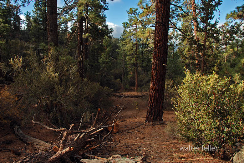
Big Bear Valley lies high in the San Bernardino Mountains, about 6,700 to 7,000 feet above sea level, forming a broad mountain basin surrounded by rugged granite peaks and forested ridges. The valley stretches roughly east–west, framed by Butler Peak and Delamar Mountain to the north, and Sugarloaf Mountain, Gold Mountain, and the San Gorgonio massif to the south and east.
The valley floor is relatively flat, a remnant of ancient glacial and erosional processes, with Big Bear Lake occupying its central depression. Originally a meadowed valley with creeks and marshes, it became a permanent lake after the Bear Valley Dams were built. The soils are derived from decomposed granite, supporting open forests and meadows interspersed with boulder-strewn slopes.
Ponderosa pine, Jeffrey pine, white fir, and incense cedar dominate the higher slopes. At the same time, black oak, manzanita, and chaparral fill the lower edges in sheltered meadows and along streams, willows and alders grow, creating rare wetland habitats for species such as the mountain yellow-legged frog and bald eagle.
The climate is alpine-mediterranean—cold, snowy winters and warm, dry summers—marked by dramatic seasonal shifts. Snowmelt feeds Big Bear Creek and Baldwin Lake, the latter a seasonal alkali flat on the eastern edge of the valley.
Ecologically, Big Bear Valley forms the upper boundary of the Mojave Desert drainage system. It captures mountain precipitation that ultimately seeps underground toward Lucerne and the Mojave River basin, linking the high forest to the desert below.
Timeline References
Big Bear Valley Historical Museum. “History of Big Bear Valley.” Big Bear Valley Historical Society, Big Bear City, CA.
BigBear.com. “Dam: The Creation of Big Bear Lake.” Big Bear Visitors Bureau.
BigBearCabins.com. “About Big Bear: A History.” Big Bear Cabins Travel Guide.
BigBearVacations.com. “A History of Big Bear.” Big Bear Vacations Blog.
San Bernardino County Museum Archives. “Mining and Settlement in the San Bernardino Mountains.”
Eastwood, John S. “The Multiple-Arch Dam of Bear Valley.” Engineering Record, 1912.
U.S. Forest Service. “San Bernardino National Forest: Ecological Subsections and Watershed Overview.”
Bear Valley Mutual Water Company. “Early Development and Water Rights History.”
Langenheim, Jean H., and P. H. Osman. “Vegetation and Ecology of the San Bernardino Mountains.” University of California Publications in Botany, 1959.
California Department of Fish and Wildlife. “Baldwin Lake Ecological Reserve Management Plan.”
San Bernardino Valley Water District. “Hydrologic History of the Bear Valley and Mojave River System.”
Wikipedia contributors. “Big Bear Lake, California.” Wikipedia, The Free Encyclopedia.
Wikipedia contributors. “Big Bear Valley Historical Museum.” Wikipedia, The Free Encyclopedia.
Brown, F. E. “The First Bear Valley Dam and the Redlands Water System.” Redlands Historical Society Papers, 1884–1905.
U.S. Geological Survey. “Geology and Hydrology of the Big Bear Lake Region, San Bernardino County, California.” Professional Paper Series.