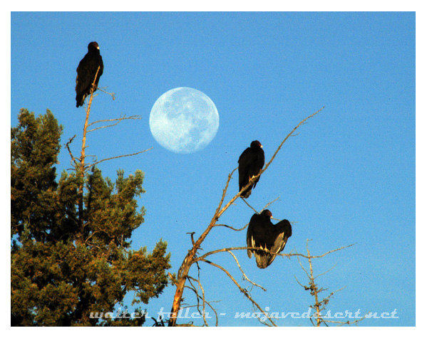
The Gourmet Vulture: A Culinary Journey in the World of Carrion
Vultures might not have Michelin stars, but they sure are the connoisseurs of the animal kingdom when it comes to dining on dead things. These winged gourmands have turned scavenging into a fine art, knowing just when to swoop in for a meal and when to pass on something that’s past its prime—or, ironically, not dead enough yet. Let’s take a peek into the culinary habits of vultures, where the timing of dinner can make all the difference between a gourmet feast and an indigestible disaster.
Scavenging: The Original “Street Food”
Long before humans were raving about food trucks and street vendors, there was scavenging. The word “scavenge” comes from Middle English and was all about cleaning up the streets, which, let’s face it, was probably a job that involved dealing with some pretty gross stuff. Fast forward a few centuries, and vultures have literally taken this concept to new heights. These birds are the ultimate street food critics, cruising the skies for the perfect carrion pile to sample. If Yelp existed in the animal kingdom, vultures would leave reviews like, “Two talons up for the tenderized deer carcass by the highway!”
Fresh Meat? No, Thanks—I Prefer It Aged
You might think vultures would be first in line for a fresh kill, but no, these birds prefer their meat with a bit of age—think of it as nature’s version of dry-aged steak. Freshly dead animals are simply too tough for these guys. They don’t have the tools to tear into a fresh carcass like their more glamorous cousins, the eagles. Vultures are more about finesse. They wait until decomposition does some of the hard work, softening up the meat and releasing those mouth-watering (well, to a vulture) aromas that say, “Dinner is served!”
It’s all about finding that sweet spot where the meat is tender enough to tear into but not so far gone that it’s turned into vulture repellent.
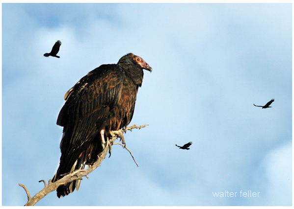
Can Meat Be Too Aged?
While vultures are happy to let nature marinate their meals, they do have standards. Yes, even vultures can find meat that’s too far gone. If a carcass is more maggot than meat, or if it’s dried out like a piece of jerky left in the sun too long, these avian food critics will pass. Sure, vultures are tough, but they’re not immune to the dangers of spoiled food. Even they know when to say, “Nope, not worth the tummy trouble.” They’re picky eaters, in their own way, balancing the need for nutrition with a healthy dose of self-preservation.
The Art of Knowing When to Eat
Vultures might not need reservations or menus, but they’ve mastered the timing of their meals. Their highly tuned senses tell them exactly when a carcass has hit that perfect stage of decay, where it’s not too fresh and not too far gone—just right for a satisfying meal. It’s like they have their own internal clock that says, “Wait for it… wait for it… now!” And in swoops the vulture, ready to feast on a meal that’s neither too tough nor too toxic. They’re not just eating; they’re ensuring the whole ecosystem stays healthy by cleaning up what other animals leave behind.
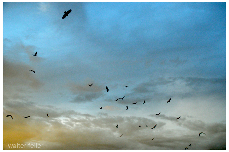
Conclusion: Vultures, The Unsung Culinary Heroes
So, next time you see a vulture circling overhead, don’t think of it as a grim reaper. Instead, imagine a discerning diner waiting for just the right moment to dive into a meal that’s perfectly aged to its taste. Vultures may not be glamorous, but they play a vital role in nature, keeping the environment clean and healthy by knowing exactly when to feast and when to fly on by. They’re the ultimate scavengers, ensuring that in the grand buffet of life, nothing goes to waste—but only if it’s just right.
Hulaville, also known as the Hulaville Forest, was a quirky and iconic roadside attraction along Route 66 near Victorville, California. It was created by artist and former carnival worker Miles Mahan in the mid-20th century. Hulaville was famous for its whimsical sculptures made from junk, like metal, old car parts, and other found objects, all arranged in a makeshift “forest” of oddities. Mahan decorated the site with hula dolls, mannequins, and other eccentric items, giving it a unique, slightly offbeat charm.
The site became a beloved stop for travelers along Route 66, offering a glimpse of the creative spirit and eccentricity that often characterized the American roadside culture of the time. Although Hulaville is no longer standing—most of it was removed or fell into disrepair over the years—it remains a fond memory for those who visited.
Today, Route 66 through Victorville is still a popular path for those exploring the Mother Road, with nearby attractions like the California Route 66 Museum in Victorville, which preserves the history and nostalgia of this famous highway. While Hulaville itself might be gone, its legacy lives on in the stories and memories of the travelers who passed through.
Sunset blushes sweet and delicate as evening primrose open a warm breeze behind you exhausted a darkening road ahead traveling by night and adventure close your eyes a weary splash of a raindrop upon the brow swaying muted light pin-point stars arrival Dawn beyond the horizon. Music.
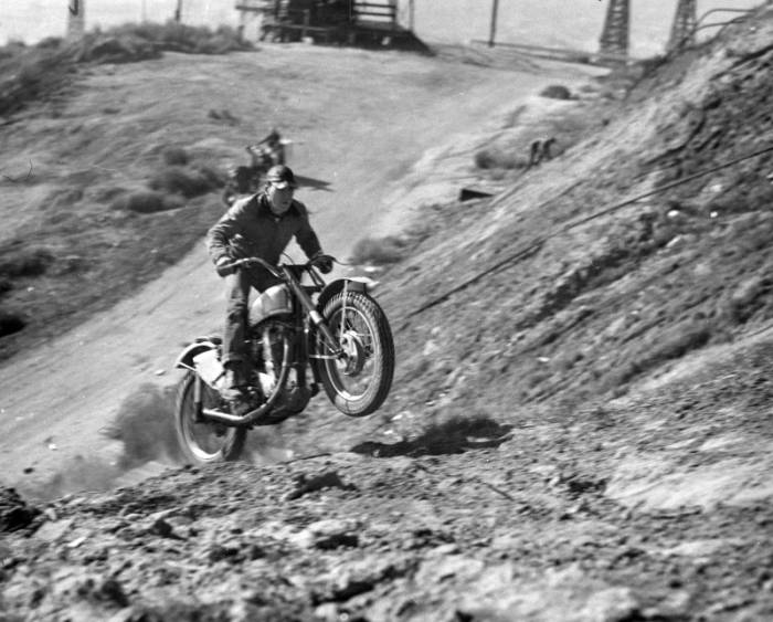
Photograph caption dated March 8, 1958 reads, “Nick Nicholson of North Hollywood is shown doing what doesn’t come easily as he negotiates a rocky and steep hill as many riders will do tomorrow in the national championship Moose Run over hill and dale in the Victorville area. (See Innocent Bystander).”
This project was supported in whole or in part by the U.S. Institute of Museum and Library Services under the provisions of the Library Services and Technology Act, administered in California by the State Librarian.; Made accessible through a grant from the John Randolph Haynes and Dora Haynes Foundation and Photo Friends.
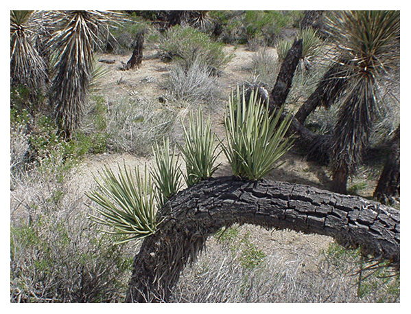
The Joshua tree, scientifically known as Yucca brevifolia, has a unique branching pattern influenced by several factors:
1. Flowering: When a Joshua tree blooms, it pauses the growth of its main stem, forming new branches. Each bloom cycle can produce more branches, contributing to its distinct shape.
2. Damage Response: Trees can branch out in response to physical damage from storms, animals, or human activity. This is a survival mechanism that ensures they continue growing despite injuries.
3. Hormonal Influences: Growth hormones within the tree, like auxins, play a role in branch development. These hormonal changes can trigger the growth of new shoots and branches.
4. Environmental Conditions: Soil quality, water availability, and sunlight can also affect how and when a Joshua tree branches. Trees in optimal conditions may branch more frequently.
These combined factors give the Joshua tree its iconic, spiky silhouette, making it a distinctive feature of the Mojave Desert landscape.
The photo in this post shows branching as a damage response #2
The Intriguing History of Panamint City Introduction Panamint City, nestled in the Panamint Range of Death Valley, California, is a ghost town with a rich and colorful history. Established in 1873, Panamint City rapidly rose to prominence as a mining boomtown, only to face an equally swift decline by the late 1870s. This essay delves into the multifaceted history of Panamint City, exploring its origins, key figures, economic dynamics, and eventual decline. Central to this narrative are the fascinating stories of stagecoach robbers turned miners, the involvement of influential senators, and the resilient spirit of the town’s inhabitants.
The Origins of Panamint City Discovery and Early Development Panamint City’s origins are as unique as they are compelling. Panamint City’s discovery involved notorious stagecoach robbers, unlike many mining towns that sprang up following discoveries by prospectors. William L. Kennedy, Robert L. Stewart, and Richard C. Jacobs hid in Surprise Canyon after successful Wells Fargo stagecoach robberies. During their hideout, they stumbled upon rich silver veins, sparking the establishment of Panamint City.
Kennedy, Stewart, and Jacobs played pivotal roles in the early development of Panamint City. Initially outlaws, these men transitioned into miners after their serendipitous discovery of silver. They cleverly capitalized on their find by contacting influential figures who could provide them with legal protection and financial backing.
The Role of Nevada Senators: John P. Jones and William M. Stewart Investment and Development Two Nevada Senators, John P. Jones and William M. Stewart, were instrumental in the development of Panamint City. Known for their substantial mining investments, these senators saw potential in the rich silver veins Kennedy, Stewart, and Jacobs discovered. They invested heavily in the mining operations, spending over $1 million, a significant sum in the 1870s.
Legal Maneuvering and Amnesty Understanding Kennedy, Stewart, and Jacobs’ legal predicaments, the senators negotiated an amnesty deal. This agreement included purchasing the claims from the outlaws and compensating Wells Fargo for the losses incurred due to previous robberies. This legal maneuvering ensured the continuity of mining operations while providing the outlaws a chance to legitimize their newfound wealth.
Economic Dynamics and Ingenious Solutions Silver Transport and Security Challenges The transport of silver from Panamint City presented significant challenges. The frequent stagecoach robberies made it impractical for Wells Fargo to service the town. The solution devised by the miners was both ingenious and practical: casting the silver into 450-pound cannonballs. These enormous ingots were too heavy for robbers to steal, ensuring the safe transport of silver to Los Angeles.
According to legend, these cannonballs, weighing around 450 pounds, were created to outwit the bandits who plagued the town. The effective solution added a unique chapter to Panamint City’s history.
Mining Operations and Infrastructure At its peak, Panamint City boasted a population of over 2,000 residents. The town developed rapidly, featuring mills, saloons, stores, a red-light district, and a cemetery. Despite its remote location and harsh living conditions, Panamint City thrived due to the rich silver veins and the substantial investments by the Nevada senators.
The Decline of Panamint City Economic Downturn and Environmental Challenges Despite the initial success, Panamint City’s fortunes began to wane by late 1875. Many of the richest silver veins were exhausted, leading to a mass exodus of miners and settlers. The collapse of the Bank of California in August 1875 further exacerbated the economic downturn, affecting the financial stability of the mining operations.
Natural Disasters In addition to economic challenges, Panamint City faced devastating natural disasters. A flash flood in July 1876 washed away much of the town, beginning its decline. Another flood in 1901 further damaged the remaining infrastructure, sealing the town’s fate as a ghost town.
The Role of Post Office Spring Strategic Importance Post Office Spring, located near Panamint City, played a crucial role in the survival of the town’s inhabitants. This spring provided a reliable water source in the arid environment of Death Valley. Its significance extended beyond sustenance, serving as a strategic location for clandestine activities.
Outlaw Mail System In the 1870s, Post Office Spring became an integral part of a secret mail system. A box was wired to one of the mesquite trees at the spring, serving as a clandestine post office. Stage drivers would leave mail addressed to “John Doe” in the box and signal its presence by tying a rag to a nearby tree. Under the cover of darkness, the wanted men of the Panamints would collect and leave their mail, maintaining a line of communication despite their fugitive status. This ingenious system reflects the resourcefulness and adaptability of the town’s inhabitants in a lawless environment.
Key Figures and Their Contributions William L. Kennedy, Robert L. Stewart, and Richard C. Jacobs These three outlaws turned miners are central to Panamint City’s story. Their discovery of silver in Surprise Canyon and subsequent transition to legitimate mining operations underscore the boom’s transformative potential. Their collaboration with influential senators to secure amnesty and investment illustrates the pragmatic alliances formed during this period.
Senators John P. Jones and William M. Stewart The Nevada senators’ involvement was crucial in Panamint City’s development. Their substantial investments and strategic legal maneuvers ensured the town’s initial success. Their innovative solution to transport silver safely reflects their business acumen and understanding of the unique challenges posed by the remote and lawless environment.
Jim Stewart and Bill Ball Jim Stewart and Bill Ball, notorious outlaws, further exemplify Panamint City’s lawlessness. Their criminal activities and resistance to law enforcement highlighted the town’s dangerous reputation. The ingenious countermeasures taken to protect silver shipments from these outlaws underscore the persistent threats the town’s legitimate operations face.
The Environment and Geography of Panamint City Surprise Canyon Surprise Canyon, where Panamint City was located, played a significant role in the town’s development and challenges. The canyon’s narrow, rugged terrain provided both protection and isolation. This geographical feature made it an ideal hideout for outlaws and posed significant challenges for transporting mined silver.
Harsh Living Conditions Panamint City’s remote location and harsh living conditions added to its unique character. The town was in a desert environment with extreme temperatures and limited resources. Despite these challenges, the promise of rich silver veins attracted a diverse population of miners, merchants, and outlaws.
The Economic Impact of Panamint City Investment and Production The significant investments made by the Nevada senators and other financiers led to substantial silver production. Panamint City was a thriving economic hub at its peak, with millions of dollars worth of silver extracted from its mines. The innovative transport solutions and substantial infrastructure development reflect the economic optimism of the time.
Decline and Financial Losses The rapid decline of Panamint City resulted in significant financial losses for the investors. The depletion of rich veins and subsequent natural disasters marked the end of the town’s economic boom. The financial impact extended beyond the immediate investors, affecting the broader economic landscape of the region.
The Social and Cultural Fabric of Panamint City Diverse Population Panamint City’s population was a mix of miners, merchants, and outlaws. This diverse demographic contributed to the town’s dynamic social fabric. The presence of a red-light district, numerous saloons, and various businesses reflect the town’s vibrant and sometimes lawless character.
Lawlessness and Vigilante Justice The lawlessness of Panamint City necessitated unique forms of justice. With limited official law enforcement, vigilante justice was common. This self-regulation shaped the town’s reputation for danger and unpredictability, shaping its historical legacy.
The Legacy of Panamint City Later Attempts and Preservation Despite its decline, Panamint City saw sporadic attempts at revival. Mining activity continued intermittently until the 1980s. Many original buildings and structures, including a prominent smokestack, still stand from the 1950s to the 1970s. These remnants preserve the town’s history, offering a glimpse into its vibrant past.
Cultural and Historical Significance Panamint City’s history reflects the broader themes of resilience and ingenuity characteristic of the American West. The town’s story, marked by discovery, lawlessness, and decline, exemplifies the spirit of those who sought fortune in the harsh desert landscape. The involvement of figures like Kennedy, Stewart, Jacobs, and the Nevada senators adds a rich layer of intrigue to the narrative, highlighting the complex interplay between legality and outlaw behavior.
Conclusion Panamint City’s rich history and unique origin story is a testament to the endurance and tenacity of those who sought fortune in the American West. The town’s narrative is filled with intriguing characters and dramatic events, from its discovery by stagecoach robbers to its rapid development and eventual decline. The involvement of key figures like Kennedy, Stewart, Jacobs, and the Nevada senators highlights the complex interplay between legality and outlaw behavior in the mining boomtowns of the 19th century. Panamint City’s legacy continues to captivate historians and enthusiasts, offering a vivid glimpse into a bygone era of ambition, innovation, and relentless pursuit of wealth.
A poignant and dramatic episode in the history of the American West, Willie Boy captures the complex dynamics between Native Americans and whitemen. Taking place in 1909, this story of love, conflict, and survival transcends its time. Willie Boy’s story depicts the struggle of a Native American man against overwhelming odds as well as broader social and political tensions of the time. In this essay, we explore the historical context, the incident, its representation in media, and its impact on American culture.
The Willie Boy story is a poignant and dramatic episode in the history of the American West, capturing the complex dynamics between Native Americans and the encroaching settlers. Taking place in 1909, this tale of love, conflict, and a relentless manhunt has transcended its time to become a symbol of cultural clash and survival. The story of Willie Boy not only highlights the individual struggle of a Native American man against overwhelming odds but also serves as a reflection of broader socio-political tensions of the era. This essay explores the historical context, the incident, its portrayal in media, and its lasting impact on American cultural narratives. In modern American culture, the story remains a testament to the enduring themes of justice, identity, and resistance against oppression.
Historical Context
The Willie Boy story unfolds in the early 20th century, a period marked by significant transformation and tension in the American West. The region, primarily inhabited by various Native American tribes, was experiencing increasing pressure from expanding settler communities and government policies aimed at assimilation. In particular, the Chemehuevi people, to which Willie Boy belonged, were navigating the challenges of preserving their cultural identity amidst these changes.
The Chemehuevi were traditionally a semi-nomadic people, living in the harsh desert environment of the Mojave. They had deep knowledge of the land, which was crucial for their survival. Their social structure was organized around small, family-based groups, and they had a rich cultural heritage that included oral storytelling, traditional dances, and ceremonies.
During this era, racial prejudices and conflicts between Native Americans and settlers were prevalent. Government policies often marginalized Native populations, stripping them of their lands and resources. The socio-political environment was one of distrust and misunderstanding, setting the stage for tragic confrontations like the one involving Willie Boy. The General Allotment Act of 1887, for example, had already fragmented many Native American communities by breaking up communal lands into individual allotments, leading to significant loss of tribal land and autonomy.
The Incident
In 1900, 19-year-old Willie Boy was living in Victorville with his sister and her family. When two young boys, ages 6 and 8, were orphaned, Willie Boy took care of them, moving them from a nearby reservation. He was known as a quiet, hard-working cowpuncher with a good, sober reputation. Despite his future national notoriety, he never left the Mojave Desert, working at ranches along California 62 in the Morongo and Yucca valleys and Joshua Tree before moving to Twentynine Palms.
There, in 1909, he fell in love with his 16-year-old distant cousin, Carlota Boniface. He had already been married, but that marriage had failed within the previous year. Carlota’s father, nicknamed “Old Mike,” who refused to let his daughter marry a relative, no matter how distant.
Tribal customs also forbade such a marriage, declaring that it would only bring shame and dishonor to their families. Despite her father’s objections, Carlota ran off with Willie Boy, and the two spent the night together before relatives brought them back.
On September 25, 1909, at Gilman Ranch outside Banning, California, Willie Boy asked again then shot and killed Old Mike in confrontation over Carlota. Willie Boy and Carlota escaped hand-in-hand into the night. A posse formed in Banning several hours later, initiating a manhunt. The posse was led by Sheriff Frank Wilson and included Deputy Charles Reche, Ed Curran, Harry Finch, Joseph Gentry, George “Red” Parker, and Ben de Crevecoeur. Both White and Indian citizens of Banning agreed on this point. The outcome was tragic: THREE DEAD AND ONE BADLY WOUNDED.
Willie Boy and Carlota fled into the Mojave Desert, pursued by a posse of local law enforcement and volunteers. The chase was arduous, spanning several days and covering treacherous terrain. Reports of the time detail the relentless pursuit, highlighting the harsh conditions and the determination of both the pursuers and the pursued. Willie Boy’s knowledge of the desert landscape allowed him to evade capture for a significant period, utilizing survival skills that were second nature to him but unfamiliar to his pursuers. His route took him through various parts of the desert, including Twentynine Palms and Old Woman Springs, as he sought to escape his pursuers.
As the chase continued, Carlota’s fate became a point of contention. Initially believed to be held captive, it was later revealed that she died during the escape, though the exact circumstances remain shrouded in mystery. Some accounts suggest she succumbed to exhaustion, while others imply she was shot. One theory posits that Carlota, unable to keep up with the grueling pace, may have been accidentally shot by Willie Boy in a tragic misunderstanding, while another suggests she might have been killed by the posse to hasten the chase.
Interestingly, during this time, President William Howard Taft was visiting Riverside, California, bringing national attention to the region. This high-profile presence, combined with the attention of reporters, likely influenced the actions of the posse. Keen to impress the President and the media, the posse may have been more aggressive and determined in their pursuit of Willie Boy, eager to showcase their commitment to law and order. The added pressure and desire for public recognition could have intensified their efforts, contributing to the relentless nature of the manhunt.
The pursuit culminated in a final standoff in the barren landscape of Ruby Mountain. Willie Boy, now alone and desperate, made his last stand. On October 8, 1909, law enforcement closed in on his location. The exact details of his death are disputed, with some reports claiming he was shot by the posse and others suggesting he took his own life to avoid capture. Regardless of the exact circumstances, Willie Boy’s death marked the end of a tragic and tumultuous chapter. The official account states that Willie Boy’s body was found with a self-inflicted gunshot wound, lying next to his rifle. However, some believe that this version of events was constructed to avoid the appearance of an unjust killing by law enforcement. Many also believe that Willie Boy escaped, lived to a ripe old age near Pahrump in Nevada, and returned every so often to the Reservation.
Media and Public Perception
The Willie Boy incident was widely reported in newspapers across the country, with the media playing a crucial role in shaping public perception. Headlines sensationalized the story, often portraying Willie Boy as a dangerous fugitive and a threat to civilized society. This portrayal fed into existing racial stereotypes and heightened the sense of fear and urgency surrounding the manhunt.
Newspapers of the time had a flair for the dramatic, often blurring the lines between news and entertainment. Some headlines read more like wild west dime novels than factual reporting: “Indian Outlaw on the Loose!”, “Deadly Love Affair Sparks Desert Chase!”, and “Willie Boy’s Last Stand – A Showdown in the Desert!”. One might wonder if the journalists were competing for the most sensational story rather than the most accurate one. Articles often included exaggerated descriptions of Willie Boy’s supposed savagery and the heroism of the posse, appealing to the public’s appetite for thrilling frontier tales.
The media’s depiction of Willie Boy was not merely a recounting of events but a crafted narrative that reflected and reinforced contemporary biases. Sensationalist reporting emphasized the exotic and perilous nature of the chase, painting Willie Boy as a symbol of the untamed wilderness and the perceived lawlessness of Native American life. This narrative served to dehumanize Willie Boy and justify the extreme measures taken to capture him.
Public reaction to the incident was mixed, with some viewing Willie Boy as a villain who deserved his fate, while others saw him as a tragic figure caught in an impossible situation. This dichotomy mirrored the broader societal attitudes towards Native Americans at the time, highlighting deep-seated prejudices and the struggle for justice and recognition. Some local residents, particularly those familiar with the harsh realities faced by Native American communities, expressed sympathy for Willie Boy, recognizing him as a victim of systemic oppression.
Legacy and Impact
The legacy of the Willie Boy story is multifaceted, influencing both local and national cultural narratives. In the immediate aftermath, the incident became a cautionary tale about the dangers of crossing cultural boundaries and the perceived need for law and order in the West. The story was used to reinforce the notion that Native Americans needed to be controlled and assimilated into mainstream society.
Over time, however, the story has been revisited and reinterpreted through various lenses. In literature, film, and popular culture, Willie Boy has been depicted as a complex character, embodying themes of resistance, love, and tragedy. The 1969 film “Tell Them Willie Boy Is Here,” starring Robert Redford and Robert Blake, brought renewed attention to the story, sparking discussions about historical accuracy and the representation of Native Americans in media. The film portrayed Willie Boy not just as a fugitive, but as a symbol of the broader struggles faced by Native Americans, highlighting the injustices they endured.
The Willie Boy story also serves as a reminder of the broader struggles faced by Native American communities during this period. It highlights the tensions between preserving cultural identity and adapting to a rapidly changing world. The incident underscores the need to critically examine historical narratives and consider the perspectives of those who have been marginalized. Contemporary scholars and activists have used the Willie Boy story to shed light on issues of racial discrimination, police violence, and the erasure of Native American history.
In addition, the story has been incorporated into local folklore and history, with annual commemorations and educational programs aimed at preserving the memory of Willie Boy and the events of 1909. These efforts help ensure that future generations understand the complexities of this historical episode and its relevance to ongoing social justice movements.
Critical Analysis
Analyzing the Willie Boy story requires a careful examination of the various perspectives and accounts. The conflicting reports about key details, such as Carlota’s death and Willie Boy’s final moments, illustrate the challenges of separating fact from legend. This ambiguity invites a deeper exploration of the motivations and biases of those who recorded the events. For instance, some accounts suggest that the posse may have fabricated elements of the story to present themselves in a more favorable light, while others argue that Willie Boy’s actions were driven by desperation and a desire for self-preservation.
From a contemporary standpoint, the Willie Boy story raises important questions about race, justice, and historical memory. It prompts us to consider how narratives are constructed and whose voices are prioritized. The story’s enduring relevance lies in its ability to provoke reflection on these issues and its role in shaping our understanding of the past.
The story also highlights the role of media in shaping public perceptions and historical memory. The sensationalist coverage of the incident not only influenced contemporary attitudes but also contributed to the enduring mythologization of Willie Boy. This phenomenon underscores the importance of critically evaluating media sources and seeking out diverse perspectives to gain a more nuanced understanding of historical events.
Conclusion
The Willie Boy story is a compelling and complex narrative that continues to resonate more than a century after the events took place. It encapsulates themes of love, conflict, and survival, set against the backdrop of a turbulent period in American history. By examining the historical context, the incident itself, media portrayal, and lasting impact, we gain a deeper understanding of this poignant chapter in the American West.
Reflecting on the Willie Boy story allows us to recognize the nuances of historical narratives and the importance of considering multiple perspectives. It serves as a reminder of the enduring struggles faced by Native American communities and the need for continued dialogue and understanding. Ultimately, the legacy of Willie Boy highlights the indomitable human spirit and the complexity of our shared history.
Wonderland Ranch, also known as the Wall Street Mill area, is a historic site within Joshua Tree National Park. This area offers a glimpse into the region’s mining history and transformation into a national park. Here are some key points about its history:
Early History: Before becoming part of Joshua Tree National Park, the area was used by Native American tribes such as the Serrano, the Chemehuevi, and the Cahuilla. The region’s resources were utilized for their livelihoods.
Mining Era: The Wonderland Ranch area became significant during the California gold rush era. Bill Keys, a prominent local figure, owned and operated the Wall Street Mill, one of the area’s best-preserved mills. The mill was primarily used for crushing gold ore, which was essential in gold extraction processes.
Bill Keys: A notable historical figure in the Joshua Tree area, Bill Keys played a pivotal role in local mining and community life. He was known for his resourcefulness and for being a central figure in the community’s development. Keys also had disputes with his neighbor, Worth Bagley, which led to a fatal shootout, adding a notorious chapter to the area’s history.
Conservation and National Park: Joshua Tree’s ecological and geological significance led to its designation as a national monument in 1936 under President Franklin D. Roosevelt. Later, it was elevated to national park status in 1994. This change helped preserve the natural and historical resources, including the remnants of the Wonderland Ranch.
Today, visitors to Joshua Tree National Park can explore the historic sites around Wonderland Ranch, including the remains of the Wall Street Mill, old mining equipment, and the rustic landscapes that tell the stories of a bygone era of ambitious miners and rugged desert life.
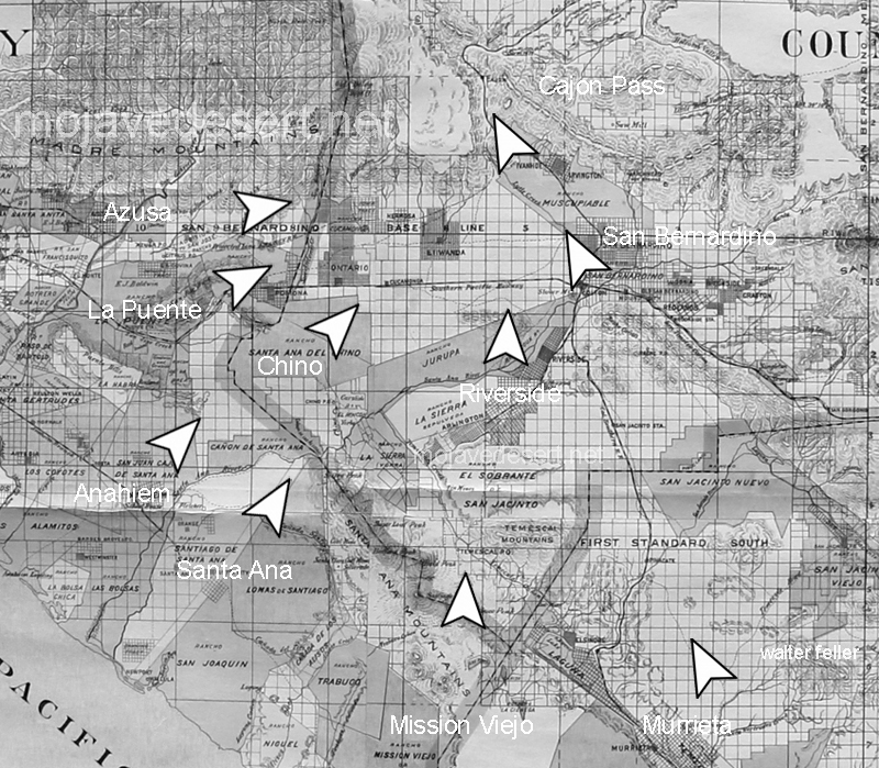
The Old Spanish Trail had become increasingly used as a pack mule trail between New Mexico and California, and with this traffic came the opportunity for those to take advantage of the distance and desperate nature of the land.
Hundreds and sometimes even thousands of stolen horses from the ranchos would burst through Coyote Canyon beginning their ‘journey of death’ across the Mojave.
California horses were beautiful creatures, and the mules were taller and stronger than those in New Mexico and they were easy to steal. The rolling hills and plains presented clear paths to the Cajon where numerous hidden canyons and washes were available to slip into and prepare for the furious run across the desert. Horses would be stolen in herds from many different ranchos at once. Hundreds of horses, even thousands could be commandeered and driven by just a few experienced thieves.
Narrows, Crowder Cyn., Cajon Pass
Chief Walkara, ‘Hawk of the Mountains’ and the greatest horse thief in all of history along with his band of renegade Chaguanosos , and notables such as Jim Beckwourth and Pegleg Smith would work together in this illegal trade. During one raid they were said to have coordinated the theft of 3,000-5,000 horses, driving them to Fort Bridger to trade for more horses to run to New Mexico to trade again. Horses would fall from exhaustion every mile and the local bands of Paiute would feast on the remains.
The rich ranchos of southern California.
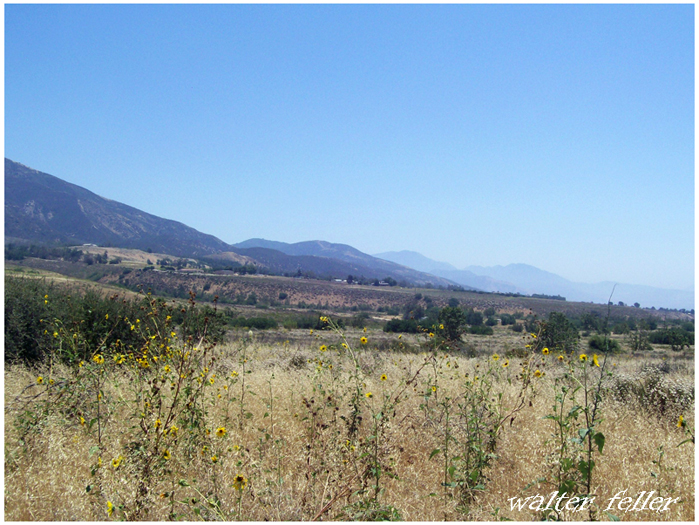
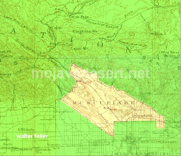
In 1843 Michael White was granted one league of land at the mouth of the Cajon Pass called Rancho Muscupiabe. At a point overlooking the trails leading into and away from the canyon he was expected to thwart the raiders and horse thieves that were plaguing the Southern California ranchos. In theory it was a good plan but in practice it did not work so well.
From the piedmont between Devil and Cable canyons, Miguel Blanco could keep an eye out for the horse thieves entering the Cajon.
He built his home of logs and earth and constructed corrals for his stock. However, the location between Cable and Devil Canyon only served as a closer and more convenient target for the Indian thieves. His family was with him, but after six weeks until it became too dangerous. He left after nine months without any livestock and in debt.
The Old Spanish Trail went down this slope to behind Miguel Blanco’s rough-hewn homestead. Indians would watch from this forest for Miguel to leave and they would slip down and steal everything that could be stolen.
Miguel sold his property, however, Miguel had misread the grant, letting the rancho go for much less than it was worth. The land described on the grant was roughly 5 times larger than Miguel thought. Blanco brought a suit but lost.
Muscupiabe Rancho
As the late 1840s and 1850s rolled by wagon roads were being developed in the canyon minimizing the effectiveness of the maze of box canyons being used to cover the escape of desperadoes on horseback. With California becoming a state frontiersmen such as Beckwourth and Peg Leg Smith would not steal from fellow Americans. Horse-thieving under U.S. law had become a crime where before it was just stealing horses from Mexicans. That was only serious if caught in the act. Americans would never extradite them. For the most part, that was the end of the horse stealing raids.