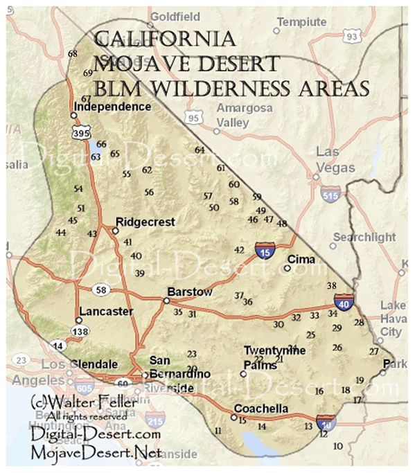
Mojave Desert Wilderness Map
The California desert contains one of the largest networks of protected wildlands in the American West. Centered on the 25-million-acre California Desert Conservation Area, these lands preserve important geological, biological, archaeological, historical, and scenic resources across Southern California. Protection is provided through wilderness areas, national monuments, conservation lands, scenic trails, and Areas of Critical Environmental Concern (ACECs).
ACECs are specially designated public lands managed to protect fragile habitats, cultural sites, unusual geological formations, and other sensitive resources. Notable examples include Fossil Falls, Trona Pinnacles, Last Chance Canyon, Afton Canyon, and Rainbow Basin. Together these areas preserve volcanic landscapes, dry lakes, riparian corridors, fossil beds, mining districts, and evidence of long human occupation.
The broader wilderness system reflects the conservation ideals formalized in the Wilderness Act of 1964, which defined wilderness as land remaining largely untouched by permanent industrial development. Today these protected desert landscapes continue to provide ecological refuge, scientific value, recreation, solitude, and some of the last remaining expanses of open undeveloped land in the American Southwest.
Numeric Index
20. San Gorgonio21. Sheephole Valley
22. Cleghorn Lakes
23. Bighorn Mountain
24. Cadiz Dunes
25. Old Woman Mountains
26. Turtle Mountains
27. Whipple Mountains
28. Chemehuevi Mountains
29. Stepladder Mountains
30. Trilobite
31. Rodman Mountains
32. Clipper Mountain
33. Piute Mountains
34. Bigelow Cholla Garden
35. Newberry Mountains
36. Bristol Mountains
37. Kelso Dunes
38. Dead Mountains
39. Black Mountain
40. Grass Valley
41. Golden Valley
42. Hollow Hills
43. El Paso Mountains
44. Bright Star
45. Kiavah
46. Kingston Range
47. Mesquite
48. Stateline
49. North Mesquite Mountains
50. Saddle Peak Hills
51. Owens Peak
54. Sacatar Trail
55. Argus Range
56. Manly Peak
57. Ibex
58. South Nopah Range
59. Pahrump Valley
60. Nopah Range
61. Resting Springs Range
62. Surprise Canyon
63. Coso Range
64. Funeral Mountains
65. Darwin Falls
66. Malpais Mesa
67. Inyo Mountains
68. Piper Mountain
69. Sylvania Mountains
Alphabetical Index
55. Argus Range34. Bigelow Cholla Garden
23. Bighorn Mountain
39. Black Mountain
44. Bright Star
36. Bristol Mountains
24. Cadiz Dunes
28. Chemehuevi Mountains
22. Cleghorn Lakes
32. Clipper Mountain
63. Coso Range
65. Darwin Falls
38. Dead Mountains
43. El Paso Mountains
64. Funeral Mountains
41. Golden Valley
40. Grass Valley
42. Hollow Hills
57. Ibex
67. Inyo Mountains
37. Kelso Dunes
45. Kiavah
46. Kingston Range 66. Malpais Mesa
56. Manly Peak
47. Mesquite
35. Newberry Mountains
60. Nopah Range
49. North Mesquite Mountains
25. Old Woman Mountains
51. Owens Peak
59. Pahrump Valley
68. Piper Mountain
33. Piute Mountains
61. Resting Springs Range
31. Rodman Mountains
54. Sacatar Trail
50. Saddle Peak Hills
20. San Gorgonio
21. Sheephole Valley
58. South Nopah Range
48. Stateline
29. Stepladder Mountains
62. Surprise Canyon
69. Sylvania Mountains
30. Trilobite
26. Turtle Mountains
27. Whipple Mountains