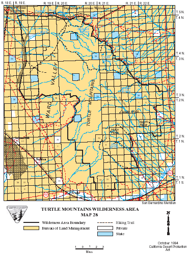
Turtle Mountains >> Map #26
Turtle Mountains Wilderness
SIZE: 144,500 acres
LOCATION: San Bernardino County; 30 miles south of Needles, California
NATURAL RESOURCES: Broad, open bajadas, eroded volcanic peaks, spires and cliffs converge to form the Turtle Mountains Wilderness. The volcanic formations shade the range in colors varying from deep reds, browns, tans and grays to black. The range lies in a horseshoe arrangement, parted by a large flat interior valley cut with numerous shallow washes. Places with names like Mopah Springs, Mohawk Springs, Coffin Springs and Gary Wash invite the dauntless wanderer, but do not rely on mapped springs for water. Always carry a gallon of water per person per day. Desert bighorn sheep, prairie falcon, golden eagle and desert tortoise make this wilderness area home.
| GLOSSARY | > bajada, spring, volcanic, wash |
ACCESS: To access the northern portion of this wilderness, go south on U.S. Highway 95 from Needles for approximately 25 miles to Turtle Mountain Road. Travel about 10 miles west, where the road splits. Take the south fork and follow the road for approximately 3 miles to an area known as Brown's Cabin or Carson's Well. Hike south into the wilderness. Careful driving is required when crossing the sandy Chemehuevi Wash. High clearance or four-wheel drive vehicles are recommended.
Geomorphic Province : Mojave Desert
Ecosection : Mojave Desert
Ecosubsection : Piute Valley - Sacramento Mountains
Native Culture : Mohave, Chemehuevi